Meadville, Pennsylvania
| Meadville | ||
|---|---|---|
| City | ||
| City of Meadville | ||
 Downtown Meadville | ||
| ||
| Etymology: David Mead, founder[1] | ||
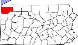
 Location of Meadville in Crawford County, Pennsylvania. | ||
 Location of Pennsylvania in the United States | ||
 Meadville Location of Meadville within Pennsylvania | ||
| Coordinates: 41°39′N 80°9′W / 41.650°N 80.150°WCoordinates: 41°39′N 80°9′W / 41.650°N 80.150°W | ||
| Country | United States | |
| State | Pennsylvania | |
| County | Crawford County | |
| Founded | 1788-05-12 | |
| Government | ||
| • Mayor | H. Leroy Stearns (D) | |
| Area[2] | ||
| • Total | 4.38 sq mi (11.34 km2) | |
| • Land | 4.38 sq mi (11.33 km2) | |
| • Water | 0.00 sq mi (0.01 km2) | |
| Elevation | 1,400 ft (400 m) | |
| Population (2010) | ||
| • Total | 13,388 | |
| • Estimate (2016)[3] | 12,964 | |
| • Density | 2,962.52/sq mi (1,143.96/km2) | |
| Time zone | UTC-5 (EST) | |
| • Summer (DST) | UTC-4 (EDT) | |
| Area code(s) | 814 | |
| FIPS code | 42-48360 | |
| Website | www.cityofmeadville.org | |
| Designated | November 1, 1946[4] | |
Meadville is a city in and the county seat of Crawford County, Pennsylvania, United States.[5] The city is within 40 miles of Erie, Pennsylvania and within 90 miles of Pittsburgh, Pennsylvania. It was the first permanent settlement in northwest Pennsylvania. The population was 13,388 at the 2010 census.[6] The city of Meadville is the principal city of the Meadville, PA Micropolitan Statistical Area. As well as one of two cities, the other being Erie, that make up the larger Erie-Meadville, PA Combined Statistical Area.
History
Meadville was settled on May 12, 1788, by a party of settlers led by David Mead. Its location was chosen well, for it lies at the confluence of Cussewago Creek and French Creek, and was only a day's travel by boat to the safety of Fort Franklin.
Their settlement was in a large meadow, first cleared by Native Americans led by Chief Custaloga, and well suited for growing maize. The village Custaloga built here was known as Cussewago.
The neighboring Iroquois and Lenape befriended the isolated settlement, but their enemies, including the Wyandots, were not so amiable. The threat of their attacks caused the settlement to be evacuated for a time in 1791.
Around 1800, many of the settlers to the Meadville area came after receiving land bounties for service in the Revolutionary War. Meadville became an important transportation center after construction of the French Creek Feeder Canal in 1837 and of the Beaver and Erie Canal it connected to at Conneaut Lake and subsequent railroad development.
In the late 18th and early 19th centuries Meadville played a small part in the Underground Railroad helping escaping slaves to freedom. An event in September 1880 led to the end of segregation by race in the state's public schools. At the South Ward schools, Elias Allen tried unsuccessfully to enroll his two children. He appealed to the Crawford County Court of Common Pleas, and Judge Pearson Church declared unconstitutional the 1854 state law mandating separate schools for Negro children. This law was amended, effective July 4, 1881, to prohibit such segregation.[7]
By the late 19th century, Meadville's economy was also driven by logging, agriculture, and iron production. The Talon Corporation, headquartered in Meadville, played a major role in the development of the zipper. Since the clothing industry was largely unaffected by the Great Depression, the community saw a population boom at that time. During World War II, the nearby Keystone Ordnance plant brought additional jobs to the area.

The high demand for zippers created favorable conditions for the Talon Company, and so became Meadville's most crucial industry. The company encountered significant difficulties after it was absorbed by Textron industries in 1968, eventually ending up bankrupt. Today, nothing remains of Talon in Meadville except for a few run down buildings. However, as a result of the need for close tolerances and tool and die makers, a cottage industry of tool and die shops was established which resulted in Meadville, earning the city the nickname Tool City with more tool shops per capita than any place else in the United States.
In 1886, a blacksmith from Evansburg, Pennsylvania George B. DeArment, a blacksmith from Evansburg, Pennsylvania, began hand-forging farrier's tools and selling them from town to town out of the back of a wagon. The business eventually became known as the Champion Bolt and Clipper Company. In 1904, now named Channellock, the company moved to a 12,000-square-foot (1,100 m2) facility in Meadville and added nippers, pinchers and open-end wrenches to its product line. George B. DeArment’s two sons, Almon W. and J. Howard DeArment, became partners in the company in 1911 and expanded the product line again to include hammers. In 1923, the company moved again to a 33,000-square-foot (3,100 m2) facility at its current location. Four years later, the name of the company was changed to the Champion–DeArment Tool Company.[8]
After World War II, Meadville's industrial growth continued. Talon remained a major employer, along with the Erie Railroad, American Viscose Corporation (later known as Avtex Fibers), Channellock tools, and Dad's Pet Food. In the 1980s, the Great Lakes region saw a decline in heavy industry. By the early 1990s, Channellock and Dad's were the only large companies operating in Meadville. This blow to the local economy was softened by subsequent surge in light industry, mainly tool and die machine shops. The area has seen growth in the 1990s and first decade of the 21st century. The song "Bittersweet Motel" by Vermont jam band, Phish, was inspired when keyboardist Page McConnell left a wedding in Meadville and drove to the Pittsburgh Airport.
In addition to the Meadville Downtown Historic District, several buildings are listed on the National Register of Historic Places: Baldwin-Reynolds House, Bentley Hall (Allegheny College), Independent Congregational Church, Dr. J. R. Mosier Office, Roueche House, Ruter Hall (Allegheny College), and Judge Henry Shippen House.[9]
Education
Colleges
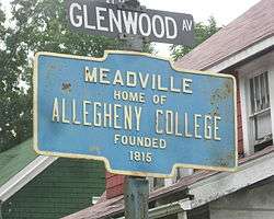
Meadville is the home of Allegheny College, a liberal arts college with approximately 2100 students. Allegheny College, the second oldest college west of the Allegheny Mountains, was founded in Meadville in 1815 and is the oldest college west of the Allegheny Mountains that has kept its original name. Allegheny was founded in April 1815[10][10] by the Reverend Timothy Alden, a graduate of Harvard's School of Divinity. The college was historically affiliated with the United Methodist Church after 1833, although it is currently non-sectarian. The first class, consisting of four male students, began their studies on July 4, 1816, without any formal academic buildings. Within six years, Alden accumulated sufficient funds to begin building a campus. The first building erected, the library, was designed by Alden himself, and is a notable example of early American architecture. Bentley Hall is named in honor of Dr. William Bentley, who donated his private library to the College, a collection of considerable value and significance. In 1824, Thomas Jefferson wrote to Alden, expressing the hope that his University of Virginia could someday possess the richness of Allegheny's library.[11] Alden served as president of the college until 1831, when financial and enrollment difficulties forced his resignation. Ruter Hall was built in 1853.[12]
Meadville Theological School was established in 1844 by a wealthy businessman and Unitarian named Harm Jan Huidekoper. It moved to Chicago in 1926.
Primary and secondary education
List of schools in Meadville, Pennsylvania
- Meadville Area Senior High School (1,025)
- Meadville Middle School (515)
- Neason Hill Elementary School (317)
- First District Elementary School (315)
- Second District Elementary School (245)
- West End Elementary School (100)
- Calvary Baptist Christian Academy (unknown)
- Seton Catholic School (unknown)
Geography
Meadville is located at 41°39′N 80°9′W / 41.650°N 80.150°W (41.642, −80.147).[13]
According to the United States Census Bureau, the city has a total area of 4.4 square miles (11 km2), all of it land.
Demographics
| Historical population | |||
|---|---|---|---|
| Census | Pop. | %± | |
| 1810 | 457 | — | |
| 1820 | 649 | 42.0% | |
| 1830 | 1,076 | 65.8% | |
| 1840 | 1,319 | 22.6% | |
| 1850 | 2,578 | 95.5% | |
| 1860 | 3,702 | 43.6% | |
| 1870 | 7,103 | 91.9% | |
| 1880 | 8,860 | 24.7% | |
| 1890 | 9,520 | 7.4% | |
| 1900 | 10,291 | 8.1% | |
| 1910 | 12,780 | 24.2% | |
| 1920 | 14,568 | 14.0% | |
| 1930 | 16,698 | 14.6% | |
| 1940 | 18,919 | 13.3% | |
| 1950 | 18,972 | 0.3% | |
| 1960 | 16,671 | −12.1% | |
| 1970 | 16,573 | −0.6% | |
| 1980 | 15,544 | −6.2% | |
| 1990 | 14,318 | −7.9% | |
| 2000 | 13,685 | −4.4% | |
| 2010 | 13,388 | −2.2% | |
| Est. 2016 | 12,964 | [3] | −3.2% |
| Sources:[14][15][5][16] | |||
As of the census[5] of 2000, there were 13,685 people, 5,436 households, and 2,891 families residing in the city. The population density was 3,145.2 people per square mile (1,214.7/km²). There were 5,985 housing units at an average density of 1,375.5 per square mile (531.2/km²). The racial makeup of the city was 91.98% White, 5.01% African American, 0.18% Native American, 0.63% Asian, 0.04% Pacific Islander, 0.34% from other races, and 1.83% from two or more races. Hispanic or Latino of any race were 1.11% of the population.
There were 5,436 households, out of which 24.8% had children under the age of 18 living with them, 36.5% were married couples living together, 13.4% had a female householder with no husband present, and 46.8% were non-families. 38.4% of all households were made up of individuals, and 16.4% had someone living alone who was 65 years of age or older. The average household size was 2.18 and the average family size was 2.86.
In the city the population was spread out, with 19.4% under the age of 18, 20.0% from 18 to 24, 22.0% from 25 to 44, 19.9% from 45 to 64, and 18.7% who were 65 years of age or older. The median age was 35 years. For every 100 females, there were 81.7 males. For every 100 females age 18 and over, there were 77.6 males.
The median income for a household in the city was $25,402, and the median income for a family was $38,227. Males had a median income of $32,813 versus $22,579 for females. The per capita income for the city was $17,290. About 13.7% of families and 22.7% of the population were below the poverty line, including 25.3% of those under age 18 and 13.3% of those age 65 or over.
Notable people
- Meghan Allen, Playboy model
- Henry Baldwin, Supreme Court justice, lone dissenter in the Amistad case
- John Joseph Bittner, geneticist and cancer biologist, who studied the genetics of breast cancer
- Cameron Carpenter, Grammy-nominated organist
- Ernestine Cobern Beyer, poet and children's author
- George Washington Cullum U.S. Army general from the civil war
- John Dick, U.S. Congressman from Pennsylvania
- Samuel Bernard Dick, U.S. Congressman from Pennsylvania
- R. Budd Dwyer, former PA State Treasurer
- Todd Erdos, Major League Baseball player
- Eugene Emerson Eubanks, (First African American) Dean, School of Education, University of Missouri Kansas City, President, National Association of Colleges of Teacher Education
- Melvin Lee Eubanks, (among first African American investment bankers to pursue successful career on Wall Street) former CEO, W.R. Lazard Investment Banking Firm
- Randy Fichtner, current Offensive Coordinator of the Pittsburgh Steelers, graduate of Meadville Area Senior High
- Charles Homer Haskins, historian, advisor to President Woodrow Wilson
- Todd Holland, television and film director and producer
- Carl Hovde (1926–2009), professor and dean during the Columbia University protests of 1968[17]
- Henry Shippen Huidekoper, Lieutenant Colonel of the 150th PA Volunteer Infantry Regiment. Awarded Congressional Medal of Honor for meritorious service on July 1, 1863 at the Battle of Gettysburg
- Alison Irwin, reality show competitor
- Lynn Jones, former Major League Baseball player
- Wade Manning, former National Football League player
- Alexander S. McDill, congressman from Wisconsin
- Ross A. McGinnis, US Army soldier who was killed in the Iraq War December 4, 2006, and was posthumously awarded the United States' highest decoration for bravery, the Medal of Honor.
- Tammy Pescatelli, comedian
- Branch Rickey, Baseball executive
- Raymond P. Shafer, former governor of Pennsylvania
- Michael S. Smith, jazz drummer and percussionist
- Sharon Stone (1958-), actress
- Gideon Sundback, member of the National Inventors Hall of Fame for his work on the development of the zipper
- Jay Tessmer, former Major League Baseball player
- Ida Tarbell, social reformer and muckraking journalist
- Vicki Van Meter, record-setting child pilot
- John K. Williams, Wisconsin state legislator
- Andrew J. Yorty, Wisconsin state legislator
- Alana Newhook , Executive vice President Dallas Stars
References
- ↑ Gannett, Henry (1905). The Origin of Certain Place Names in the United States. U.S. Government Printing Office. p. 204.
- ↑ "2016 U.S. Gazetteer Files". United States Census Bureau. Retrieved Aug 13, 2017.
- 1 2 "Population and Housing Unit Estimates". Retrieved June 9, 2017.
- ↑ "PHMC Historical Markers Search" (Searchable database). Pennsylvania Historical and Museum Commission. Commonwealth of Pennsylvania. Retrieved January 25, 2014.
- 1 2 3 "American FactFinder". United States Census Bureau. Retrieved January 31, 2008.
- ↑ "Find a County". National Association of Counties. Retrieved June 7, 2011.
- ↑ HistoricalMarkers.com Retrieved on December 14, 2008.
- ↑ Ward, Logan (May 2009). "Top 50 Important Tools". Popular Mechanics. Archived from the original on 2010-02-11. Retrieved 2010-02-09.
- ↑ National Park Service (2010-07-09). "National Register Information System". National Register of Historic Places. National Park Service.
- 1 2 Stewart, Anne W. (February 7, 2003). "Nothing New Under the Sun". The Wall Street Journal. Retrieved August 26, 2009.
- ↑ Haskins, Charles H.; Hull, William I. (1902). A History of Education in Pennsylvania. Washington Government Printing Office. p. 10.
- ↑ "National Historic Landmarks & National Register of Historic Places in Pennsylvania" (Searchable database). CRGIS: Cultural Resources Geographic Information System. Note: This includes John P. Davis (December 1977). "National Register of Historic Places Inventory Nomination Form: Ruter Hall" (PDF). Archived from the original (PDF) on December 5, 2014. Retrieved June 23, 2013.
- ↑ "US Gazetteer files: 2010, 2000, and 1990". United States Census Bureau. February 12, 2011. Retrieved April 23, 2011.
- ↑ "Number of Inhabitants: Pennsylvania" (PDF). 18th Census of the United States. U.S. Census Bureau. Retrieved November 22, 2013.
- ↑ "Pennsylvania: Population and Housing Unit Counts" (PDF). U.S. Census Bureau. Retrieved November 22, 2013.
- ↑ "Incorporated Places and Minor Civil Divisions Datasets: Subcounty Population Estimates: April 1, 2010 to July 1, 2012". U.S. Census Bureau. Archived from the original on June 17, 2013. Retrieved November 25, 2013.
- ↑ Hevesi, Dennis. "Carl F. Hovde, Former Columbia Dean, Dies at 82", The New York Times, September 10, 2009 Accessed September 11, 2009.
External links
| Wikimedia Commons has media related to Meadville, Pennsylvania. |
- City website
- Alfred Huidekoper's 1850 chronology
- The Crawford County Historical Society

Places adjacent to Meadville, Pennsylvania | ||||||||||
|---|---|---|---|---|---|---|---|---|---|---|
| ||||||||||