Elk Township, Chester County, Pennsylvania
| Elk Township | |
|---|---|
| Township | |
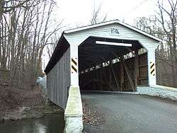 Glen Hope Covered Bridge | |
 Location in Chester County and the U.S. state of Pennsylvania. | |
| Coordinates: 39°43′30″N 75°51′59″W / 39.72500°N 75.86639°WCoordinates: 39°43′30″N 75°51′59″W / 39.72500°N 75.86639°W | |
| Country | United States |
| State | Pennsylvania |
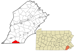
| County | Chester |
| Area[1] | |
| • Total | 10.13 sq mi (26.22 km2) |
| • Land | 10.05 sq mi (26.03 km2) |
| • Water | 0.07 sq mi (0.19 km2) |
| Elevation | 390 ft (120 m) |
| Population (2010) | |
| • Total | 1,681 |
| • Estimate (2016)[2] | 1,694 |
| • Density | 168.52/sq mi (65.07/km2) |
| Time zone | UTC-5 (EST) |
| • Summer (DST) | UTC-4 (EDT) |
| Area code(s) | 610 |
| FIPS code | 42-029-23032 |
| Website |
www |
Elk Township is a township in Chester County, Pennsylvania, United States. The population was 1,681 at the 2010 census.
Geography
According to the United States Census Bureau, the township has a total area of 10.2 square miles (26 km2), all of it land.
History
The Rudolph and Arthur Covered Bridge, Linton Stephens Covered Bridge, and Glen Hope Covered Bridge are listed on the National Register of Historic Places.[3]
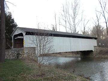 Rudolph and Arthur Covered Bridge
 Little Elk Friends Meeting, built 1826
Demographics
| Historical population | |||
|---|---|---|---|
| Census | Pop. | %± | |
| 1930 | 404 | — | |
| 1940 | 457 | 13.1% | |
| 1950 | 462 | 1.1% | |
| 1960 | 539 | 16.7% | |
| 1970 | 649 | 20.4% | |
| 1980 | 750 | 15.6% | |
| 1990 | 1,129 | 50.5% | |
| 2000 | 1,485 | 31.5% | |
| 2010 | 1,681 | 13.2% | |
| Est. 2016 | 1,694 | [2] | 0.8% |
| [4] | |||
At the 2010 census, the township was 89.9% non-Hispanic White, 1.6% Black or African American, 0.5% Native American, 1.2% Asian, and 1.4% were two or more races. 5.7% of the population were of Hispanic or Latino ancestry.[5]
As of the census[6] of 2000, there were 1,485 people, 515 households, and 410 families residing in the township. The population density was 145.2 people per square mile (56.0/km²). There were 527 housing units at an average density of 51.5 per square mile (19.9/km²). The racial makeup of the township was 96.90% White, 0.81% African American, 0.13% Asian, 0.81% from other races, and 1.35% from two or more races. Hispanic or Latino of any race were 3.64% of the population.
There were 515 households, out of which 40.4% had children under the age of 18 living with them, 68.5% were married couples living together, 7.8% had a female householder with no husband present, and 20.2% were non-families. 16.3% of all households were made up of individuals, and 5.0% had someone living alone who was 65 years of age or older. The average household size was 2.88 and the average family size was 3.26.
In the township the population was spread out, with 29.8% under the age of 18, 5.3% from 18 to 24, 32.6% from 25 to 44, 24.4% from 45 to 64, and 7.9% who were 65 years of age or older. The median age was 36 years. For every 100 females, there were 99.9 males. For every 100 females age 18 and over, there were 99.2 males.
The median income for a household in the township was $60,380, and the median income for a family was $70,104. Males had a median income of $46,635 versus $30,179 for females. The per capita income for the township was $24,604. About 2.8% of families and 3.8% of the population were below the poverty line, including 3.3% of those under age 18 and 3.4% of those age 65 or over.
References
- ↑ "2016 U.S. Gazetteer Files". United States Census Bureau. Retrieved Aug 13, 2017.
- 1 2 "Population and Housing Unit Estimates". Retrieved June 9, 2017.
- ↑ National Park Service (2010-07-09). "National Register Information System". National Register of Historic Places. National Park Service.
- ↑ http://www.dvrpc.org/data/databull/rdb/db82/appedixa.xls
- ↑ https://www.usatoday.com/news/nation/census/profile/PA
- ↑ "American FactFinder". United States Census Bureau. Archived from the original on 2013-09-11. Retrieved 2008-01-31.