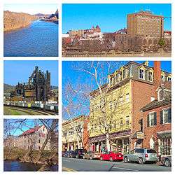
Bethlehem, Pennsylvania
| Bethlehem, Pennsylvania | ||
|---|---|---|
| City | ||
 | ||
| ||
| Nickname(s): The Christmas City,[1] The Steel City | ||
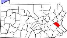
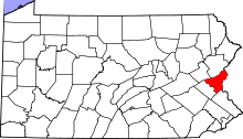
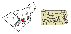 Location of Bethlehem in Northampton County, Pennsylvania. | ||
 Bethlehem Location in Pennsylvania  Bethlehem Bethlehem (the US) | ||
| Coordinates: 40°37′34″N 75°22′32″W / 40.62611°N 75.37556°WCoordinates: 40°37′34″N 75°22′32″W / 40.62611°N 75.37556°W | ||
| Country | United States | |
| State | Pennsylvania | |
| Counties | Lehigh and Northampton | |
| Founded | December 24, 1741 | |
| Government | ||
| • Type | Mayor-Council | |
| • Mayor | Robert J. Donchez | |
| Area[2] | ||
| • City | 15.05 sq mi (38.99 km2) | |
| • Land | 14.80 sq mi (38.34 km2) | |
| • Water | 0.25 sq mi (0.65 km2) | |
| • Urban | 289.50 sq mi (749.79 km2) | |
| • Metro | 730.0 sq mi (1,174.82 km2) | |
| Elevation | 360 ft (109.728 m) | |
| Population (2010) | ||
| • City | 55,639 | |
| • Estimate (2016)[3] | 75,293 | |
| • Density | 3,752.55/sq mi (1,448.83/km2) | |
| • Urban | 576,408 | |
| • Metro | 740,395 | |
| Time zone | UTC-5 (EST) | |
| • Summer (DST) | UTC-4 (EDT) | |
| ZIP Codes | 18015-18018 | |
| Area code(s) | 610 and 484 | |
| FIPS code | 42-06088 | |
| Website | bethlehem-pa.gov | |
Bethlehem is a city in Lehigh and Northampton counties in the Lehigh Valley region of the eastern portion of the U.S. state of Pennsylvania. As of the 2010 census, the city had a total population of 74,982, making it the seventh largest city in Pennsylvania, after Philadelphia, Pittsburgh, Allentown, Erie, Reading, and Scranton.[4] Of this, 55,639 were in Northampton County, and 19,343 were in Lehigh County.
Bethlehem lies in the center of the Lehigh Valley, a region of 731 sq mi (1,890 km2) that is home to more than 800,000 people. Together with Allentown and Easton, the Valley embraces the Allentown-Bethlehem-Easton, PA-NJ metropolitan area, including Lehigh, Northampton, and Carbon counties within Pennsylvania, and Warren County in the adjacent state of New Jersey. Smaller than Allentown but larger than Easton, Bethlehem is the Lehigh Valley's second most populous city. In turn, this metropolitan area comprises Pennsylvania's third-largest metropolitan area and the state's largest and most populous contribution to the greater New York City metropolitan area.
There are four general sections of the city: central Bethlehem, the south side, the east side, and the west side. Each of these sections blossomed at different times in the city's development and each contains areas recognized under the National Register of Historic Places. ZIP codes that use the address Bethlehem totaled 116,000 in population in the year 2000. These ZIP codes include Bethlehem Township and Hanover Township.
The Norfolk Southern Railway's Lehigh Line (formerly the main line of the Lehigh Valley Railroad), runs through Bethlehem heading east to Easton, Pennsylvania and Phillipsburg, New Jersey across the Delaware River. The Norfolk Southern Railway's Reading Line runs through Bethlehem heading west to Allentown and Reading.
In July 2006, Money magazine placed Bethlehem as number 88 on its "Top 100 Best Places to Live."[5]
History
The areas along the Delaware River and its tributaries in eastern Pennsylvania were long inhabited by indigenous peoples of various cultures. By the time of European contact, these areas were the historic territory of the Algonquian-speaking Lenape Nation, which had three main divisions, the Unami, Unalachtigo, and Munsee. They traded with the Dutch and then English colonists in the mid-Atlantic area.
On Christmas Eve in 1741, David Nitschmann and Count Nicolaus von Zinzendorf, leading a small group of Moravians, founded the mission community of Bethlehem along the banks of the Monocacy Creek by the Lehigh River in the colony of Pennsylvania. They came to set up missionary communities among the Native Americans and unchurched German-speaking Christians. They named the settlement after the Biblical town Bethlehem of Judea, the birthplace of Jesus. "Count Zinzendorf said, 'Brothers, how more fittingly could we call our new home than to name it in honor of the spot where the event we now commemorate took place. We will call this place Bethlehem.' And so was Bethlehem named after the birthplace of the Man of Peace.'" (from a letter by Gordon Dent to Mr. T. Donald Bain March 3, 1965 quoting from "Story of Bethlehem Steel" by Arundel Cotter, more details are given in this article) Originally it was a typical Moravian Settlement Congregation, where the Church owned all the property. Until the 1850s, only members of the Moravian Church were permitted to lease land plots in Bethlehem. The historic Brethren's House, Sisters' House, Widows' House and Gemeinhaus (Congregation House) with the Old Chapel are remnants of this period of communal living.[6]
The Moravians ministered to regional Lenape Native Americans through their mission in the area, as well as further east in the New York colony. In the historic Bethlehem God's Acre cemetery, converted Lenape lie buried alongside the Moravians.
In 1762, Bethlehem built the first water-works in America to pump water for public use. While George Washington and his troops stayed in Valley Forge, Washington stored his personal effects at the farm of James Burnside in Bethlehem – as of 1998 a historical museum (Burnside Plantation).[7]
The prosperous village was incorporated into a free borough in the County of Northampton in 1845. After the Unity Synod of 1848, Bethlehem became the headquarters of the Northern Province of the Moravian Church in North America.[8]
On March 27, 1900, the Bach Choir of Bethlehem presented the United States debut of German Lutheran Johann Sebastian Bach's Mass in B Minor in the city's Central Moravian Church.
Boroughs merge
After the Civil War the Borough of South Bethlehem was formed. In 1886 the Borough of West Bethlehem (in Lehigh County) was formed. In 1904, the Boroughs of West Bethlehem (in Lehigh County) and Bethlehem (in Northampton County) merged. In 1917, the Borough of South Bethlehem and Bethlehem merged to become the City of Bethlehem, with Archibald Johnston (1865-1948) selected as the new city's first mayor. Bethlehem Township, Pennsylvania has remained a separate political entity. Even after the merger of the two boroughs, the bureau initially provided a count for the original sections.
| Census | All Three boroughs | South Bethlehem | Original Bethlehem | West Bethlehem | Bethlehem & West Bethlehem | Bethlehem Township |
|---|---|---|---|---|---|---|
| 1850 | ----- | 1,516 | ----- | ----- | ||
| 1860 | ----- | 2,868 | ----- | ----- | ||
| 1870 | 3,556 | 4,512 | ----- | 2,230 | ||
| 1880 | 4,925 | 5,193 | ----- | 2,282 | ||
| 1890 | 19,823 | 10,302 | 6,762 | 2,759 | 9,521 | 2,397 |
| 1900 | 23,999 | 13,241 | 7,293 | 3,465 | 10,758 | 3,090 |
| 1910 | 32,810 | 19,973 | 8,365 | 4,472 | 12,837 | 3,414 |
Bethlehem Steel
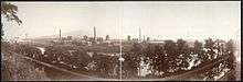
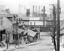
Bethlehem became a center of heavy industry and trade during the industrial revolution. The Bethlehem Steel Corporation (1857–2003), founded and based in Bethlehem, was once the second-largest steel producer in the United States, after Pittsburgh, Pennsylvania-based U.S. Steel. Bethlehem Steel was also one of the largest shipbuilding companies in the world and one of the most powerful symbols of American industrial manufacturing leadership.
Bethlehem Steel began producing the first wide-flange structural shapes made in the United States and they pioneered the production of the now-ubiquitous "I-beam" used in construction of steel-framed buildings, including skyscrapers. It manufactured construction materials for numerous New York and other city skyscrapers, as well as for major bridges.
The company became a major supplier of armor plate and ordnance products during World War I and World War II, including the manufacture of 1,100 warships. After roughly 140 years of metal production at its Bethlehem plant, Bethlehem Steel ceased operations there in 1995, in the face of overseas competition and declining demand.
Christmas star
On December 7, 1937, at a grand ceremony during the Great Depression, Mrs. Marion Brown Grace pulled a large switch to turn on the new Christmas street lights and a large wooden star. Mrs. Grace was the daughter of former South Bethlehem burgess, Charles F. Brown, and wife of Eugene Grace, President of Bethlehem Steel Corporation. Hundreds of citizens attended the ceremony and thousands more listened to the speeches and musical performances on the radio. This was the first year the Bethlehem Chamber of Commerce adopted the nickname "Christmas City, USA".

The Hotel Bethlehem was chosen for the ceremony because it was built on the site of the first building in Bethlehem – a two-room log house – where on Christmas Eve 1741, the original settlers conducted their evening worship. As their benefactor, Count Zinzendorf, observed the farm animals that shared the space and listened to them sing the hymn, "Not Jerusalem, But Lowly Bethlehem", he proclaimed the name of the settlement to be Bethlehem. The people gathered at the 1937 ceremony heard the same words when the Bach Choir sang the old German hymn, "Jesu, Rufe Mich (Jesus, Call Thou Me)", by Adam Drese.
The Bethlehem Globe-Times paid for the large wooden star erected on the top of South Mountain, at a cost of $460. The original star was created with four wooden planks, overlapped to create an eight-point star, 60 feet high by 51 feet wide, mounted on two wooden poles, and lit by 150 50-watt light bulbs. The installation of the star was done by Pennsylvania Power and Light and the Bethlehem Water Department. The star was erected on the top of South Mountain, on property owned by the Water Department, located in Lower Saucon Township.
In 1939, the wooden star was replaced with a star made of Bethlehem steel, at a cost of $5,000. It had eight rays, with the main horizontal ray 81 feet wide and the main vertical ray 53 feet high. In 1967, the current star, 91 feet high, was installed on the old steel frame and set in a concrete base 25 feet wide by 5 feet deep. Plexiglas was installed to protect the 250 50-watt light bulbs. In the summer of 2006, the city repaired the base. A crew of municipal electricians changes the bulbs every two years. Beginning in the mid-1990s, the star was lit from 4:30 p.m. until midnight, every day of the year.
During World War II, from 1941 to 1945, none of the Christmas decorations in Bethlehem were lit. City officials said the lit star made "too good of an air raid target" and "during the global strife it didn't seem right for the lights to be all lit up when our boys were out in the darkness fighting for us". When lit, the star can be seen from as far as Wind Gap, 20 miles (32 km) away. The star has become an important symbol for Bethlehem.
Geography
According to the United States Census Bureau, the city has a total area of 19.4 square miles (50 km2), of which, 19.3 square miles (50 km2) of it is land and 0.2 square miles (0.52 km2) of it (0.88%) is water. Bethlehem is about 50 miles (80 km) north of Philadelphia and about 80 miles (130 km) west of New York City.
Because large volumes of water were required in the steelmaking process, the city purchased 22,000 acres (8,900 ha) of land in the Pocono Mountains, where its water is stored in reservoirs.
Climate
Bethlehem has a humid continental climate (Dfa). Summers are typically hot and humid, fall and spring are generally mild, and winter is cold. Precipitation is distributed throughout the year, with thunderstorms in the summer, showers in spring and fall, and snow in winter. The average high temperature varies widely, from 36 °F (2 °C) in January to 84 °F (29 °C) in July. The highest recorded temperature was 105 °F (41 °C), while the lowest recorded temperature was −16 °F (−27 °C).
Bethlehem falls under the USDA 6b Plant Hardiness zone.[9]
| Climate data for Bethlehem | |||||||||||||
|---|---|---|---|---|---|---|---|---|---|---|---|---|---|
| Month | Jan | Feb | Mar | Apr | May | Jun | Jul | Aug | Sep | Oct | Nov | Dec | Year |
| Record high °F (°C) | 72 (22) |
76 (24) |
87 (31) |
94 (34) |
97 (36) |
100 (38) |
105 (41) |
105 (41) |
99 (37) |
93 (34) |
81 (27) |
72 (22) |
105 (41) |
| Average high °F (°C) | 36 (2) |
40 (4) |
49 (9) |
61 (16) |
72 (22) |
80 (27) |
84 (29) |
82 (28) |
75 (24) |
64 (18) |
53 (12) |
41 (5) |
61 (16) |
| Average low °F (°C) | 19 (−7) |
22 (−6) |
29 (−2) |
39 (4) |
48 (9) |
58 (14) |
63 (17) |
61 (16) |
53 (12) |
41 (5) |
33 (1) |
24 (−4) |
41 (5) |
| Record low °F (°C) | −16 (−27) |
−12 (−24) |
−5 (−21) |
12 (−11) |
29 (−2) |
39 (4) |
38 (3) |
41 (5) |
31 (−1) |
19 (−7) |
3 (−16) |
−9 (−23) |
−16 (−27) |
| Average precipitation inches (mm) | 3.03 (77) |
2.80 (71.1) |
3.39 (86.1) |
3.56 (90.4) |
4.14 (105.2) |
4.31 (109.5) |
4.95 (125.7) |
3.69 (93.7) |
4.62 (117.3) |
3.88 (98.6) |
3.50 (88.9) |
3.58 (90.9) |
45.45 (1,154.4) |
| Source: The Weather Channel[10] | |||||||||||||
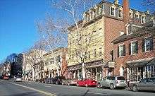
Cityscape
Neighborhoods
Bethlehem is divided into four main areas: Center City, West Side, East Side, and South Side. The West Side is located in Lehigh County, while the other three neighborhoods are located in Northampton county.
- Center City is bounded by the Monocacy Creek to the west, Hanover and Bethlehem townships (both Northampton County) to the north, and Stefko Boulevard to the east.
- The West Side begins at the city's western border with Allentown and continues east to the Monocacy Creek and north to Hanover Township (Lehigh County).
- The Mount Airy Neighborhood is bounded by Pennsylvania Ave to the west, W. Broad St to the north, 2nd Ave to the east and the Lehigh River to the south.
- The East Side is bordered to the west by Center City and to the east by Bethlehem Township and Freemansburg. The East Side includes the Pembroke Village area.
- The South Side's borders are Fountain Hill to the west, the Lehigh River to the north, South Mountain to the south, and Hellertown to the east.
Demographics
| Historical population | |||
|---|---|---|---|
| Census | Pop. | %± | |
| 1850 | 1,516 | — | |
| 1860 | 2,866 | 89.1% | |
| 1870 | 4,512 | 57.4% | |
| 1880 | 5,193 | 15.1% | |
| 1890 | 6,762 | 30.2% | |
| 1900 | 7,293 | 7.9% | |
| 1910 | 12,837 | 76.0% | |
| 1920 | 50,358 | 292.3% | |
| 1930 | 57,892 | 15.0% | |
| 1940 | 58,490 | 1.0% | |
| 1950 | 66,340 | 13.4% | |
| 1960 | 75,408 | 13.7% | |
| 1970 | 72,686 | −3.6% | |
| 1980 | 70,419 | −3.1% | |
| 1990 | 71,428 | 1.4% | |
| 2000 | 71,329 | −0.1% | |
| 2010 | 74,982 | 5.1% | |
| Est. 2016 | 75,293 | [3] | 0.4% |
| Sources:[11][12][13] | |||
As of the census[12] of 2010, there were 74,982 people residing in the city. There were 31,221 housing units, with 5.9% vacant. The racial makeup of the city was 76.4% White, 6.9% African American, 0.3% Native American, 2.9% Asian, 0.0% Pacific Islander, 10.0% from other races, and 3.4% from two or more races. Hispanic or Latino of any race were 24.4% of the population.
As of the census[12] of 2000, there were 71,329 people residing in the city, including 17,094 families and 28,116 households. The population density was 3,704.4 people per square mile (1,429.9/km²). There were 29,631 housing units at an average density of 1,538.8 per square mile (594.0/km²). The racial makeup of the city was 81.85% White, 3.64% African American, 0.26% Native American, 2.22% Asian, 0.03% Pacific Islander, 9.44% from other races, and 2.56% from two or more races. Hispanic or Latino of any race were 18.23% of the population. There were 28,116 households, out of which 26.3% had children under the age of 18 living with them, 44.1% were married couples living together, 12.8% had a female householder with no husband present, and 39.2% were non-families. 32.3% of all households were made up of individuals, and 14.4% had someone living alone who was 65 years of age or older. The average household size was 2.34 and the average family size was 2.95.
In the city, the population was spread out, with 21.0% under the age of 18, 14.4% from 18 to 24, 26.6% from 25 to 44, 20.1% from 45 to 64, and 17.9% who were 65 years of age or older. The median age was 36 years. For every 100 females, there were 91.5 males. For every 100 females age 18 and over, there were 88.6 males.
The median income for a household in the city was $35,815, and the median income for a family was $45,354. Males had a median income of $35,190 versus $25,817 for females. The per capita income for the city was $18,987. About 11.1% of families and 15.0% of the population were below the poverty line, including 20.7% of those under age 18 and 8.8% of those age 65 or over.
The city is served by Lehigh Valley International Airport, which also serves Allentown, Pennsylvania and the greater Lehigh Valley.
Economy
In December 2006, Las Vegas Sands Corp was awarded a Category 2 Slot Machine License by the Pennsylvania Gaming Control Board. LVSC began work on the site, categorized as both the largest brownfield redevelopment project in the nation and the largest casino development investment made to date in the Commonwealth. Its mission was to create reinvestment and urbanization in the area. At a projected cost of $743 million, the historic Bethlehem Steel plant is being redeveloped as a fully integrated resort, to include 3,000 slot machines, over 300 hotel rooms, 9 restaurants, 200,000 square feet (19,000 m2) of retail outlet shopping, and 46,000 square feet (4,300 m2) of flexible multi-purpose space.[14] In 2007, the casino resort company of Las Vegas Sands began the construction of Sands Casino Resort Bethlehem. The Sands Casino has been projected to bring in approximately one million dollars in revenue per day as of 2009.
Another major economic anchor to the city is St. Luke's Hospital located in neighboring Fountain Hill. That Hospital and Health Network is the second largest of its type in the Lehigh Valley. Other major employers include B. Braun, Lehigh University, and the Guardian Life Insurance Company of America.[15]
Other companies in Bethlehem include the candy company Just Born.
Shopping
Over the past two decades, many shops and restaurants have opened in the city's downtown and South Side.[16] In the mid-1970s, West Broad Street between New and Guetter Streets in center city was converted to a pedestrian plaza. The buildings on the south side of the block were torn down and replaced by an enclosed mall and 11-story office tower.[17] The tower, at One Bethlehem Plaza on the corner of Broad and New, continues to operate, but the 80,000-square-foot mall, which was erected in response to the development of suburban shopping malls, failed. Since then, the block has been reopened to traffic, and the mall has been converted into offices for PowerSchool, a major software company based in California, and the Internal Revenue Service.[18][17]
In recent years, retail business in downtown Bethlehem, particularly along Main Street south of Broad, has experienced a renaissance, based on the city's historic character.[19] The two-block shopping area is anchored by Moravian College's Main Street Campus and Central Moravian Church at the southern end and The Bethlehem Commons indoor mall and historic Sun Inn (1758) at its northern end. In between, numerous boutiques have opened, selling artwork, gifts, clothing, antiques, crafted beverages, gourmet foods, jewelry, hand cut crystal, holiday decorations, and other specialties.[20] Among the blocks' additional attractions are the Moravian Book Shop (1745), the country's oldest continuously operating bookstore, and the historic Hotel Bethlehem (1922).[20][21] Meanwhile, on the city's South Side, stores and restaurants have sprung up on Third and Fourth Streets, largely because of the presence of Lehigh University but also tied to the opening of the Sands Casino and the development of the SteelStacks Arts and Cultural campus.[16][22]
Outside the center city there are several shopping centers:
- Westgate Mall, on Schoenersville Road, is an enclosed mall anchored by The Bon-Ton department store and Weis Markets.
- Lehigh Center Shopping Center, on Union Boulevard near the Allentown border, includes Marshalls/HomeGoods, Staples, Giant supermarket, and Big Lots.
- Martin Court Shopping Center, on Eighth Avenue near Rt. 378, has Lowe's and PriceRite.
- Stefko Boulevard Shopping Center, between Washington and Easton Avenues, includes Valley Farm Market, Dollar Tree, VIA Thrift Store, Pennsylvania Wine and Spirits, J's Steaks and Subs, and The Meadows Frozen Custard.
- Bethlehem Squares shopping center, on the edge of the city in Bethlehem Township, has Giant supermarket, TJMaxx, Wal-Mart, and The Home Depot.
Infrastructure
Transportation
Interstate 78 passes to the south of Bethlehem and has access to the city at an interchange with Pennsylvania Route 412. U.S. Route 22 passes to the north of Bethlehem on the Lehigh Valley Thruway and has access to the city at interchanges with Pennsylvania Route 378, Schoenersville Road, Pennsylvania Route 512 (Center Street), and Pennsylvania Route 191 (Linden Street). PA 378 runs north-south through Bethlehem, passing through the southern part of the city on Wyandotte Street, crossing the Lehigh River on the Hill to Hill Bridge, and heading through the northern part of the city on a freeway to US 22. PA 412 enters Bethlehem from the south at an interchange with I-78 on the border with Hellertown and runs north and west through the southern part of the city to its northern terminus at PA 378.[23][24]
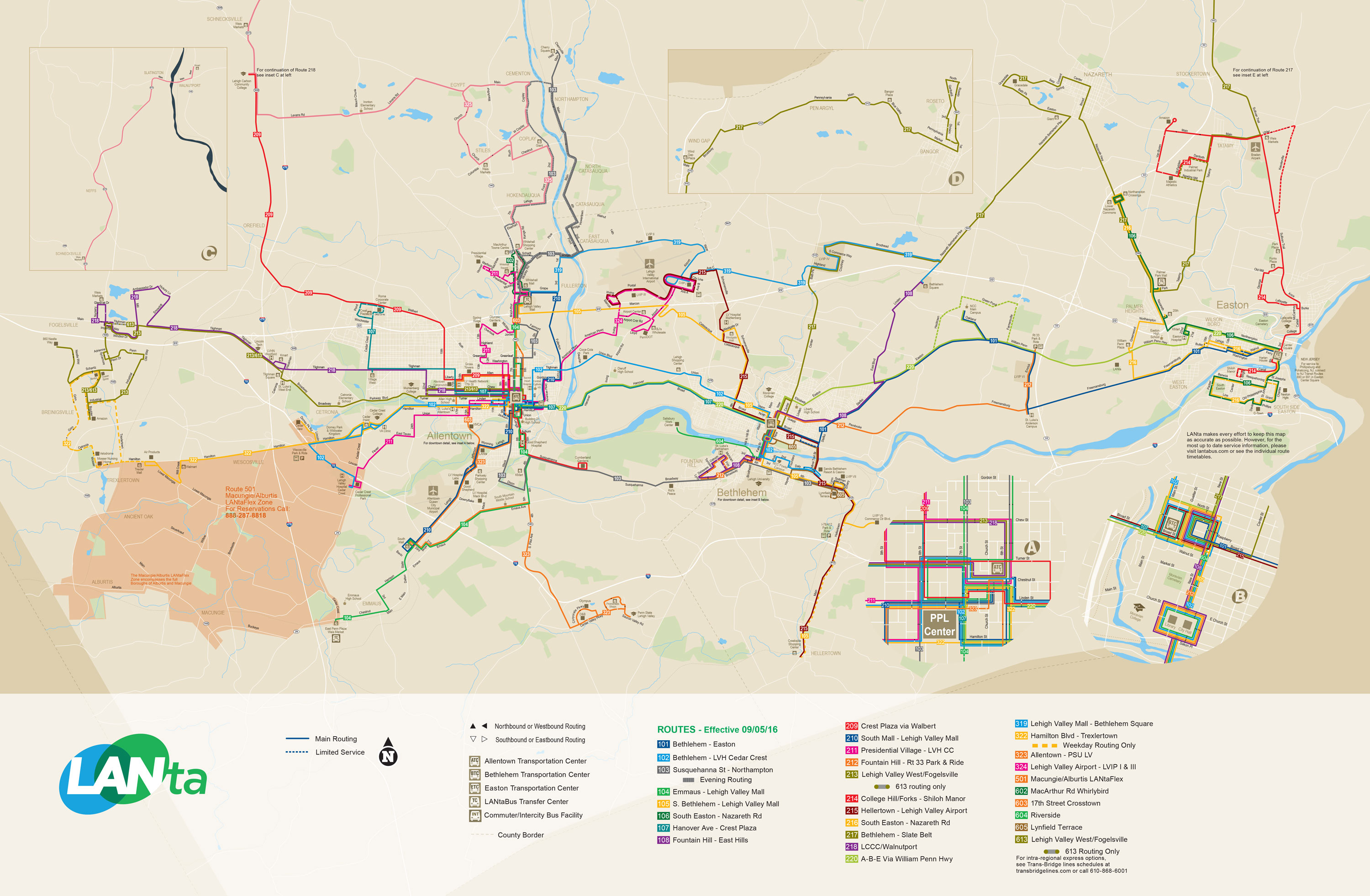
LANTA provides local bus service in Bethlehem, serving points in the city and providing connections to Allentown, Easton, the Lehigh Valley Mall, and other points in the Lehigh Valley. The Bethlehem Transportation Center at Broad and Guetter streets serves as a transit hub for LANTA buses in Bethlehem.[25] Bieber Transportation Group and Trans-Bridge Lines provide intercity bus service in Bethlehem, stopping at the Bethlehem Transportation Center and the Sands Casino Resort Bethlehem bus terminal. Bieber Transportation Group provides service to the Philadelphia Greyhound Terminal in Philadelphia, the Weehawken Port Imperial ferry terminal in Weehawken, New Jersey (where a ferry connection to New York City is available), and Reading.[26][27] Trans-Bridge Lines provides service from Bethlehem to Port Authority Bus Terminal in New York City along two routes, one of which runs from Allentown and Bethlehem to New York City and the other which runs from Bethlehem to New York City via Doylestown, Pennsylvania and Flemington, New Jersey[28][29]
Freight rail service in Bethlehem is provided by the Norfolk Southern Railway and Lehigh Valley Rail Management. Norfolk Southern Railway operates the Lehigh Line through the city along the Lehigh River, with the Reading Line splitting from the Lehigh Line in Bethlehem.[23][24] Bethlehem formerly had passenger rail service at the Bethlehem Union Station, which originally served the Lehigh Valley Railroad and Reading Company and had service along SEPTA's Bethlehem Line south to Philadelphia until 1981, when service was cut back to Quakertown and later Lansdale. The Central Railroad of New Jersey formerly provided passenger rail service to the city at the Bethlehem station.
The Lehigh Valley International Airport is located northwest of Bethlehem and provides commercial air service to the area.
Utilities
Electricity in Bethlehem is provided by PPL Electric Utilities.[30][31] UGI Utilities supplies natural gas to the city.[32][33] The City of Bethlehem Department of Water & Sewer Resources provides water and sewer service to Bethlehem and parts of 10 adjacent municipalities in Lehigh and Northampton counties, serving 35,000 water customers and 25,000 sewer customers. The city's water supply comes from the Pocono Mountains, with the surface water sources containing 10 billion gallons of freshwater capacity in an area consisting of 23,000 acres of protected watershed.[34] Trash collection in Bethlehem is provided by private haulers while the City of Bethlehem Recycling Department provides recycling collection.[35]
Politics and government
The city government is composed of a mayor and a seven-person city council.
Mayor Robert Donchez was sworn in on January 6, 2014. The previous mayor of Bethlehem was John B. Callahan, who was elected to his second term in November 2005. His election marked the 10th consecutive year a Democrat has held the city's highest office.[36]
Callahan is a member of the Mayors Against Illegal Guns Coalition,[37] a bi-partisan group with a stated goal of "making the public safer by getting illegal guns off the streets." The Coalition was founded by former Boston Mayor Thomas Menino and New York City Mayor Michael Bloomberg.
Federally, Bethlehem is part of Pennsylvania's 15th congressional district, represented by Republican Charlie Dent, elected in 2004.
Crime
| Bethlehem | |
|---|---|
| Crime rates* (2009) | |
| Violent crimes | |
| Homicide | 1.4 |
| Forcible rape | 22.1 |
| Robbery | 132.7 |
| Aggravated assault | 146.5 |
| Total violent crime | 302.7 |
| Property crimes | |
| Burglary | 504.5 |
| Larceny-theft | 1,994.5 |
| Motor vehicle theft | 171.4 |
| Arson | 18.0 |
| Total property crime | 2,670.4 |
|
Notes *Number of reported crimes per 100,000 population. 2009 population: 72,349 Source: 2009 FBI UCR Data | |
Bethlehem has a significantly lower crime rate than that of Allentown and Easton. In 2008, Bethlehem had an overall crime index of 244.4,[38] while Allentown's crime index was 510.4[39] and Easton's crime index was 379.2.[40] The United States' average was 320.9.
Education
Colleges and universities

Bethlehem is home to three institutes of higher education. Lehigh University, located on South Mountain on the city's South Side, has 5,000 undergraduates and 2,100 graduate students.[41] The university, which was founded in 1865, was ranked No. 44 in U.S. News & World Report's 2017 ratings of America's best colleges.[42]
Moravian College, located in the center city area, is a small, highly respected liberal arts college. Founded in 1742 as Bethlehem Female Seminary, Moravian is the sixth oldest college in the nation.[43] Besides undergraduate programs, the college also includes the Moravian Theological Seminary, a graduate school with approximately 100 students from more than a dozen religious denominations.[44]
The International Institute for Restorative Practices is a graduate school dedicated to the advanced education of professionals and to the conduct of research that can develop the growing field of restorative practices.[45] The IIRP offers two master's degrees: the Master of Restorative Practices and Education (MRPE) and the Master of Restorative Practices and Youth Counseling (MRPYC). The IIRP also offers an 18-credit Graduate Certificate in Restorative Practices.[46]
The main campus of Northampton Community College is located in neighboring Bethlehem Township, but it does have a satellite campus within the city.
Primary and secondary education
Bethlehem is home to the Bethlehem Area School District (BASD), which covers a 40-square-mile (100 km2) area that includes the city, the boroughs of Fountain Hill and Freemansburg, and Bethlehem and Hanover Townships.[47] The district operates two high schools for grades 9–12: Liberty High School near center city and Freedom High School in neighboring Bethlehem Township.
The district also has four public middle schools for grades 6–8: Broughal Middle School, East Hills Middle School, Nitschmann Middle School, and Northeast Middle School. In addition, BASD maintains 16 public elementary schools for grades K-5: Asa Packer Elementary School, Calypso Elementary School, Clearview Elementary School, Donegan Elementary School, Farmersville Elementary School, Fountain Hill Elementary School, Freemansburg Elementary School, Governor Wolf Elementary School, Hanover Elementary School, James Buchanan Elementary School, Lincoln Elementary School, Marvine Elementary School, Miller Heights Elementary School, Spring Garden Elementary School, Thomas Jefferson Elementary School, and William Penn Elementary School. Lehigh Valley Charter High School for the Arts is also operated by the district, though it accepts students in grades 9–12 from throughout Northampton and surrounding counties.
Bethlehem has two private high schools: Bethlehem Catholic High School, which serves grades 9–12, and Moravian Academy, which serves all primary and secondary school grades. Notre Dame High School, located just north of the city, also serves grades 9 through 12.
Bethlehem Catholic, Freedom and Liberty all compete athletically in Pennsylvania's Eastern Pennsylvania Conference.
Media
Bethlehem's daily newspaper, The Globe-Times, ceased publication in 1991. The Morning Call, based in Allentown, and The Express-Times, based in Easton, are now the city's dominant newspapers. Other smaller newspapers include the Bethlehem Press; an award-winning weekly, Pulse Weekly, based in Allentown; Eastern Pennsylvania Business Journal, based in Bethlehem; and Lehigh Valley Sports Extra, an all-sports monthly newspaper founded in 2001.
Religious broadcaster WBPH is the only television station licensed in Bethlehem, though WLVT Channel 39, a PBS affiliate, has its operations in the city. WFMZ Channel 69, an independent station, is based in neighboring Allentown. Bethlehem is part of the Philadelphia DMA and its cable systems also receive select radio and television broadcasts from New York City.
Bethlehem has two licensed commercial radio stations, variety WGPA AM, and hard rock WZZO FM (though the latter's facilities are in Whitehall Township). There is also one non-commercial station, WLVR FM, operated by Lehigh University. In addition, public radio station WDIY FM, while licensed in Allentown, maintains its facilities in Bethlehem. There are numerous other stations broadcast from Allentown and Easton representing a variety of commercial formats, as well as several translators of public stations from Philadelphia and New Jersey.
Sports
| Club | League | Venue | Established | Championships |
|---|---|---|---|---|
| Bethlehem Steel FC | USL, Soccer | Goodman Stadium | 2016 | 0 |
Lehigh Valley Storm, Lehigh Valley Steelhawks and Philadelphia Eagles
A semi-professional football team, the Lehigh Valley Storm, is based in the city. Bethlehem is also home to the Lehigh Valley Steelhawks, a Professional Indoor Football League team who played their home games at Stabler Arena in Bethlehem till they moved to PPL Center in Allentown for 2014.
From 1996 to 2012, the Philadelphia Eagles of the National Football League held their pre-season training camp each summer at the football facilities of Bethlehem's Lehigh University. As of 2013, the contract expired with the Philadelphia Eagles choosing to hold pre-season camp closer to home in South Philadelphia.[48]
Stabler Arena
Bethlehem also is home to Lehigh University's Stabler Arena, which hosts numerous athletic and music events. Stabler is home to the Professional Indoor Football League's Lehigh Valley Steelhawks and to Lehigh University collegiate basketball.
High school athletics
Bethlehem-area high schools, including Bethlehem Catholic High School, Freedom High School and Liberty High School, compete athletically in the Eastern Pennsylvania Conference.
Other
In the early part of the 20th century, Bethlehem had a corporate soccer team, the Bethlehem Steel F.C., which won the 1918–19 championship in the National Association Football League (NAFL), and then won what amounted to national championships three more times during the next decade (1920–21 in the NAFL; 1926–27 in the American Soccer League I; and in 1928–29 winning the EPSL II). The Bethlehem Steel sides consisted largely of British imported players and also had the distinction of being the first American professional soccer team to play in Europe, which it did during its tour of Sweden in 1919. The team also won the National Challenge Cup, now called the Lamar Hunt U.S. Open Cup after billionaire sports franchise owner Lamar Hunt, five times beginning in 1915, and for the last time in 1926.
The Lehigh Valley RFC rugby union team play their home matches at Monocacy Park.
Recreation and entertainment
The city is famous for its annual Musikfest, a largely free, ten-day music festival that draws over a million people to the city each August. Since its founding in 1898, The Bach Choir of Bethlehem has been attracting thousands of visitors to the annual Bethlehem Bach Festival,[49] now held largely on the campus of Lehigh University and on the historic grounds of the Moravian Community. Other festivals include The Celtic Classic, which celebrates Celtic culture, food and music,[50] and the SouthSide Film Festival, a non-competitive, not-for-profit film festival. The city has also been the past, and current host of the North East Art Rock Festival, or NEARFest, a popular 3-day Progressive rock music event.
The Bethlehem Area Public Library is a popular destination for recreation and entertainment.[51] The Banana Factory houses studios of area artists and is open to the public every first Friday of the month.[52] Touchstone Theatre, also on the SouthSide, houses the Valley's only professional resident theatre company, producing and presenting original theatre performances.[53]
Historic Bethlehem features many specialized boutiques, spas and nightclubs along its main streets.
On the first Friday of the month, the businesses of the Southside Shopping District hosts First Friday,[54] a celebration of arts and culture. Stores, restaurants and art galleries stay open late and offer special discounts, refreshments, gallery openings and more.
Lehigh University's Zoellner Arts Center offers a variety of musical and dramatic events through the year.
The city is the location of Pennsylvania's largest casino, the Sands Casino Resort Bethlehem, located on the former Bethlehem Steel property.
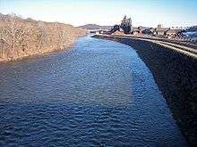
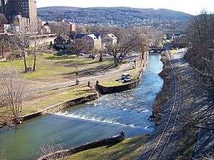
The Lehigh Canal provides hiking and biking opportunities along the canal towpath which follows the Lehigh River in Bethlehem. Both the Lehigh Canal and the Monocacy Creek are popular for sport fishing, and both are stocked annually with trout.
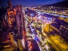
The western part of the former Bethlehem Steel site was selected as a filming location for the movie Transformers: Revenge of the Fallen, which was released in 2009. In the film, the Steel's blast furnaces and surrounding area are used for the opening sequence of the film to represent Shanghai.
In spring 2011, the city opened Steel Stacks, a ten-acre campus that showcases music, art, festivals, films and educational programming throughout the year.[55] It is located in the backdrop of the blast furnaces of the former Bethlehem Steel plant.
City parks
Bethlehem owns 39 park sites, encompassing 568 acres (2.3 km2). Among the city's parks are Buchannan Park, Elmwood Park, Illick's Mill Park, Johnston Park, Monocacy Park, Rockland Park, Rose Garden, Sand Island, Saucon Park, Sell Field, South Mountain Park, Triangle Park, West Side Park, and Yosko Park.[56][57]
Notable people
.jpg)

- Jeff Andretti, professional race car driver.
- John Andretti, professional race car driver, raced in NASCAR and IndyCar Series.
- Michael Andretti, professional racing team owner, former professional race car driver.
- David A. Bader, Georgia Tech professor.
- Chuck Bednarik, former professional football player, Philadelphia Eagles, Pro Football Hall of Fame member.
- Michael Behe, biochemist at Lehigh University, advocate of intelligent design.
- Stephen Vincent Benét, writer.
- Pete Carril, former professional and collegiate basketball coach.
- Alexandra Chando, actress.
- H.D., writer, poet.
- Russell Davenport, publisher and writer.
- Jimmy DeGrasso, drummer, Alice Cooper band, former drummer, Megadeth.
- Richard Diehl, archaeologist, academic and Mesoamericanist scholar.
- Edwin Drake, oil driller.
- Jonathan Frakes, director and actor, Star Trek: The Next Generation.
- Mark Wayne Glasmire, singer.
- Murray H. Goodman (born 1925), real estate developer[58]
- Eugene Grace, industrialist, President of Bethlehem Steel, 1916–1945.
- John Valentine Haidt, German-born American painter and lay Moravian preacher.
- Mel Harris, actress, ABC's thirtysomething.
- Mike Hartenstine, former professional football player.
- Darrun Hilliard, professional basketball player, San Antonio Spurs
- George Hrab, musician.
- Dwayne "The Rock" Johnson, professional wrestler and actor.
- Archibald Johnston, industrialist, mayor, and civic leader.
- Steve Kimock, freeform rock guitarist.
- Gelsey Kirkland, ballerina.
- Nathan Homer Knorr, religious leader and 3rd president, Jehovah's Witnesses.
- Joe Kovacs, world champion, Olympic silver medalist in shot put.
- Noel LaMontagne, former professional football player, Cleveland Browns.
- Gary Lavelle, former professional baseball player, Oakland Athletics, San Francisco Giants and Toronto Blue Jays.
- Barry W. Lynn, executive director of Americans United for Separation of Church and State.
- John E. Madden, thoroughbred trainer in National Museum of Racing and Hall of Fame.
- Zach Makovsky, mixed martial artist fighting in UFC's flyweight division.
- John E. McGlade, Chairman, Chief Executive Officer and President of Air Products & Chemicals.
- Alix Olson, spoken word poet.
- Bob Parsons, football player for Penn State and Chicago Bears.
- Billy Packer, CBS basketball analyst.
- Daniel Roebuck, actor, ABC's Lost.
- Thom Schuyler, country music singer and songwriter.
- Charles M. Schwab, industrialist, former President of U.S. Steel, later founded and was first Chairman of Bethlehem Steel Corporation.
- Sheetal Sheth, actress, Looking for Comedy in the Muslim World.
- John Spagnola, former professional football player, Green Bay Packers, Philadelphia Eagles and Seattle Seahawks.
- Donald Smaltz, lawyer.
- Sarah Strohmeyer, novelist, creator of Bubbles.
- Jonathan Taylor Thomas, actor, ABC's Home Improvement.
- Melissa VanFleet, singer/songwriter and musician.
In popular culture
- In the comic strip Dennis the Menace, Dennis' grandfather lives in Bethlehem. A three-part holiday story, "Dennis in the Christmas City," has been reprinted frequently since its original appearance in 1963.[59]
Related communities
| Wikimedia Commons has media related to Bethlehem, Pennsylvania. |
Sister cities


Twin cities
See also
References
- ↑ "Welcome to the Christmas City". ChristmasCity.org website. Retrieved March 22, 2009.
- ↑ "2016 U.S. Gazetteer Files". United States Census Bureau. Retrieved Aug 14, 2017.
- 1 2 "Population and Housing Unit Estimates". Retrieved June 9, 2017.
- ↑ U.S. Census Bureau, 2010. Retrieved 25 March 2011.
- ↑ "MONEY Magazine: Best places to live 2006: Top 100 76–100". CNN.
- ↑ "Exploring the Religious History of the Lehigh Valley at the Moravian Historical Society Museum". Uncovering PA. Retrieved 25 December 2017.
- ↑ "weekly news briefs". tnonline.com. Archived from the original on July 9, 2004.
- ↑ "Moravian Church in North America: Our History" Archived August 29, 2008, at the Wayback Machine.
- ↑ Agricultural Research Center, PRISM Climate Group Oregon State University. "USDA Plant Hardiness Zone Map". USDA. Archived from the original on February 27, 2014. Retrieved February 24, 2014.
- ↑ "Monthly Averages for Bethlehem, PA". Retrieved August 3, 2013.
- ↑ "Census of Population and Housing". U.S. Census Bureau. Archived from the original on May 12, 2015. Retrieved December 11, 2013.
- 1 2 3 "American FactFinder". United States Census Bureau. Archived from the original on September 11, 2013. Retrieved January 31, 2008.
- ↑ "Incorporated Places and Minor Civil Divisions Datasets: Subcounty Resident Population Estimates: April 1, 2010 to July 1, 2012". Population Estimates. U.S. Census Bureau. Archived from the original on June 17, 2013. Retrieved December 11, 2013.
- ↑ "Sands Casino - Resort - Bethlehem". May 12, 2009. Archived from the original on May 12, 2009.
- ↑ "Top 25 Greater Lehigh Valley Employers - GLVR".
- 1 2 "Bethlehem Pennsylvania Guide, July 2010-July 2011" (PDF). Greater Lehigh Valley Chamber of Commerce. Retrieved 2017-12-01.
- 1 2 "Beyond Steel: Past Revitalization Efforts". Lehigh University. Retrieved 2017-12-01.
- ↑ Salamone, Anthony (February 2, 2017), "Bethlehem's SunGard K-12 sold in $850M deal", The Morning Call, retrieved 2017-12-01
- ↑ Zimmerman, Karl (December 25, 2011), "Bethlehem, Pa.'s German Christmas tradition", Los Angeles Times, retrieved 2017-12-01
- 1 2 "Get Downtown and Experience Bethlehem: Shopping and Salons". Downtown Bethlehem Association. Retrieved 2017-12-01.
- ↑ High, John (August 14, 2000), "PW: Centenarian Booksellers II", Publishers Weekly, retrieved 2017-12-01
- ↑ "SteelStacks Arts and Cultural Campus". Urban Land Institute. Retrieved 2017-12-01.
- 1 2 Lehigh County, Pennsylvania Highway Map (PDF) (Map). PennDOT. 2015. Retrieved January 23, 2016.
- 1 2 Northampton County, Pennsylvania Highway Map (PDF) (Map). PennDOT. 2015. Retrieved January 17, 2016.
- ↑ System Map (Map). LANTA. Retrieved February 14, 2018.
- ↑ "Daily Bus Service to Philadelphia, PA". Bieber Transportation Group. January 8, 2017. Retrieved February 6, 2017.
- ↑ "Daily Bus Service to New York City, NY". Bieber Transportation Group. January 8, 2017. Retrieved February 6, 2017.
- ↑ "Allentown/Clinton/New York Route/Bethlehem Transportation Center to New York City" (PDF). Trans-Bridge Lines. June 4, 2018. Retrieved August 27, 2018.
- ↑ "Doylestown/Flemington/New York Route/Bethlehem Transportation Center to New York City" (PDF). Trans-Bridge Lines. June 4, 2018. Retrieved August 27, 2018.
- ↑ "Service Area". PPL Electric Utilities. Retrieved August 20, 2017.
- ↑ "General Tariff" (PDF). PPL Electric Utilities. June 20, 2017. p. 4. Retrieved August 20, 2017.
- ↑ "Geographic Footprint". UGI. Retrieved October 4, 2017.
- ↑ "Gas Tariff" (PDF). UGI Utilities. July 7, 2017. pp. 5–6. Retrieved October 10, 2017.
- ↑ "Bethlehem Water & Sewer Resources". Bethlehem, Pennsylvania. Retrieved August 27, 2018.
- ↑ "Recycling Services". Bethlehem, Pennsylvania. Retrieved August 27, 2018.
- ↑ "Mayor's Biography: John B. Callahan". City of Bethlehem website. Retrieved November 22, 2008.
- ↑ "Coalition Members". Mayors Against Illegal Guns Coalition web site. Archived from the original on March 27, 2008. Retrieved November 22, 2008.
- ↑ "Bethlehem, Pennsylvania". city-data.com.
- ↑ "Allentown, Pennsylvania". city-data.com.
- ↑ "Easton, Pennsylvania". city-data.com.
- ↑ "About Lehigh". Lehigh University. Archived from the original on September 26, 2009. Retrieved August 29, 2009.
- ↑ "Best Colleges 2017". U.S. News & World Report. Retrieved August 29, 2016.
- ↑ "About Moravian College". Moravian College. Archived from the original on August 15, 2009. Retrieved August 29, 2009.
- ↑ "About MTS". Moravian Theological Seminary. Archived from the original on April 18, 2009. Retrieved August 29, 2009.
- ↑ "Archived copy". Archived from the original on October 1, 2011. Retrieved 2011-08-11.
- ↑ "Graduate Certificate in RP - International Institute for Restorative Practices". iirp.edu. Archived from the original on October 1, 2011.
- ↑ "Citylife: Education". City of Bethlehem website. Archived from the original on October 24, 2009. Retrieved August 29, 2009.
- ↑ "No more training camp at Lehigh University for Birds", By Nick Fierro, March 15, 2013.
- ↑ bach.org/history.php
- ↑ "Celtic Classic 2015 - Bethlehem, PA - Highland Games, Irish and Celtic Music Festival". celticfest.org.
- ↑ "Welcome to Bethlehem Area Public Library". bapl.org.
- ↑ "Banana Factory — Arts & Education Center". bananafactory.org.
- ↑ "Touchstone Theatre". touchstone.org.
- ↑ "First Friday, Southside Bethlehem". Downtown Bethlehem Association. Retrieved May 10, 2010.
- ↑ "Archived copy". Archived from the original on December 7, 2013. Retrieved 2014-01-20.
- ↑ "Parks and Recreation, Comprehensive Plan 2008" (PDF). City of Bethlehem. Archived from the original (PDF) on December 17, 2008. Retrieved November 22, 2008.
- ↑ "Parks, Recreation & Public Property". City of Bethlehem website. Archived from the original on December 8, 2008. Retrieved November 22, 2008.
- ↑ "The Goodman Company - A History of Shopping Center Excellence". thegoodmancompany.com.
- ↑ Dennis the Menace Giant # 19, Winter 1963
- ↑ Radzievich, Nicole. "Bethlehem welcomes Corfu, fourth sister city". The Morning Call. Retrieved April 2, 2014.
External links
| Wikimedia Commons has media related to Bethlehem, Pennsylvania. |
| Wikivoyage has a travel guide for Bethlehem (Pennsylvania). |
- Official website.
- Official visitor website.
- Bethlehem, Pennsylvania: A Moravian Settlement in Colonial America, a National Park Service Teaching with Historic Places (TwHP) lesson plan.
- Teachinghistory.org review of web resource, Bethlehem Digital History Project

Places adjacent to Bethlehem, Pennsylvania | |
|---|---|