Laporte, Pennsylvania
| Laporte, Pennsylvania | ||
|---|---|---|
| Borough | ||
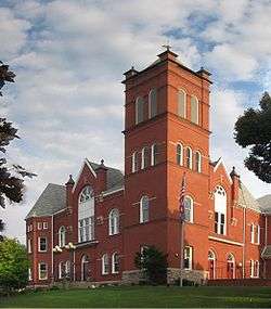 The Sullivan County Courthouse, built 1894, in Laporte | ||
| ||
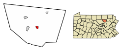 Location of Laporte in Sullivan County, Pennsylvania. | ||
 Laporte Location within the U.S. state of Pennsylvania  Laporte Laporte (the US) | ||
| Coordinates: 41°25′24″N 76°29′27″W / 41.42333°N 76.49083°WCoordinates: 41°25′24″N 76°29′27″W / 41.42333°N 76.49083°W | ||
| Country | United States | |
| State | Pennsylvania | |
| County | Sullivan | |
| Settled | 1850 | |
| Incorporated (borough) | 1853 | |
| Area[1] | ||
| • Total | 1.23 sq mi (3.19 km2) | |
| • Land | 1.07 sq mi (2.76 km2) | |
| • Water | 0.16 sq mi (0.42 km2) | |
| Elevation | 1,972 ft (601 m) | |
| Population (2010) | ||
| • Total | 316 | |
| • Estimate (2016)[2] | 300 | |
| • Density | 280.90/sq mi (108.50/km2) | |
| Time zone | Eastern (EST) | |
| • Summer (DST) | EDT | |
| ZIP code | 18626 | |
| Area code(s) | 570 Exhange: 946 | |
| FIPS code | 42-41512 | |
| Website |
www | |
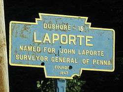
Laporte is a borough in Sullivan County, Pennsylvania, United States. The population was 316 at the 2010 census. It is the county seat of Sullivan County.[3] Laporte is surrounded by Laporte Township. It was named for John Laporte. It is the smallest county seat in Pennsylvania by population (as of the 2000 Census),[4] and in 1969 was one of the two smallest in the United States.[5]
History
The Sullivan County Courthouse was added to the National Register of Historic Places in 1978.[6]
Geography
According to the United States Census Bureau, the borough has a total area of 1.3 square miles (3.4 km2), of which 1.1 square miles (2.8 km2) is land and 0.2 square miles (0.52 km2) (12.50%) is water. Within the borough lies Lake Mokoma.
Demographics
As of the census of 2010,[10] there were 316 people, 109 households, and 67 families residing in the borough. The population density was 287.3 people per square mile (112.2/km²). There were 251 housing units at an average density of 228.2 per square mile (89.1/km²). The racial makeup of the borough was 98.1% White, 0.6% African American, 0.9% Native American, and 0.3% Asian. Hispanics or Latinos of any race makes up 0.9% of the borough population.
There were 109 households out of which 14.7% had children under the age of 18 living with them, 54.1% were married couples living together, 3.7% had a female householder with no husband present, and 38.5% were non-families. 34.9% of all households were made up of individuals and 22% had someone living alone who was 65 years of age or older. The average household size was 2.01 and the average family size was 2.54.
In the borough the population was spread out with 8.5% under the age of 18, 49.1% from 18 to 64, and 42.4% who were 65 years of age or older. The median age was 61.7 years.
The median income for a household in the borough was $43,750, and the median income for a family was $52,500. Males had a median income of $30,625 versus $25,500 for females. The per capita income for the borough was $18,762. About 3.6% of families and 7.4% of the population were below the poverty line, including 10.9% of those under the age of eighteen and none of those sixty five or over.
References
- ↑ "2016 U.S. Gazetteer Files". United States Census Bureau. Retrieved Aug 14, 2017.
- 1 2 "Population and Housing Unit Estimates". Retrieved June 9, 2017.
- ↑ "Find a County". National Association of Counties. Retrieved 2011-06-07.
- ↑ Williams, Oliver P. (2001). County Courthouses of Pennsylvania: A Guide. Stackpole Books. ISBN 0-8117-2738-6. Retrieved 2013-12-26.
- ↑ Taber, Thomas Townsend, III (1969). Muncy Valley Lifeline: The Life and Times of the Williamsport and North Branch and Eagles Mere Railroads. Muncy Valley Historical Society. Retrieved 2008-02-09.
- ↑ National Park Service (2010-07-09). "National Register Information System". National Register of Historic Places. National Park Service.
- ↑ "Census of Population and Housing". U.S. Census Bureau. Retrieved 11 December 2013.
- ↑ "American FactFinder". United States Census Bureau. Retrieved 2008-01-31.
- ↑ "Incorporated Places and Minor Civil Divisions Datasets: Subcounty Resident Population Estimates: April 1, 2010 to July 1, 2012". Population Estimates. U.S. Census Bureau. Archived from the original on 17 June 2013. Retrieved 11 December 2013.
- ↑ "American FactFinder". United States Census Bureau. Retrieved 2011-05-14.
Municipalities and communities of Sullivan County, Pennsylvania, United States | ||
|---|---|---|
| Boroughs | 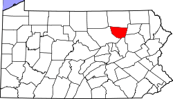 | |
| Townships | ||
| Unincorporated communities |
| |
| Ghost town | ||