Tunkhannock, Pennsylvania
| Borough of Tunkhannock | |
|---|---|
| Borough | |
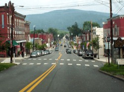 Downtown Tunkhannock, looking east along Tioga Street (U.S. Route 6 Business). | |
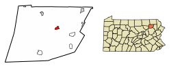 Location of Tunkhannock in Wyoming County, Pennsylvania. | |
 Tunkhannock Location of Tunkhannock in Pennsylvania  Tunkhannock Tunkhannock (the US) | |
| Coordinates: 41°32′27″N 75°56′52″W / 41.54083°N 75.94778°WCoordinates: 41°32′27″N 75°56′52″W / 41.54083°N 75.94778°W | |
| Country | United States |
| State | Pennsylvania |
| County | Wyoming |
| Founded | 1841 |
| Government | |
| • Mayor | Norm Ball |
| Area[1] | |
| • Total | 0.96 sq mi (2.49 km2) |
| • Land | 0.91 sq mi (2.36 km2) |
| • Water | 0.05 sq mi (0.13 km2) |
| Elevation | 692 ft (211 m) |
| Population (2010) | |
| • Total | 1,836 |
| • Estimate (2016)[2] | 1,761 |
| • Density | 1,930.92/sq mi (745.49/km2) |
| Time zone | UTC-5 (EST) |
| • Summer (DST) | UTC-4 (EDT) |
| ZIP code | 18657 |
| Area code(s) | 570 Exchanges: 836,996 |
| FIPS code | 42-77784 |
| Website |
www |

Tunkhannock is a borough in Wyoming County, Pennsylvania, 31 miles (50 km) northwest of Wilkes-Barre. In the past, lumbering was carried on extensively. Today, many residents are employed by the Procter & Gamble plant in nearby Washington Township. As of the 2010 census, the borough population was 1,836. It is the county seat of Wyoming County.[3] Tunkhannock is in the Scranton–Wilkes-Barre–Hazleton, PA Metropolitan Statistical Area.
The name Tunkhannock comes from the Minsi-Len'api term Ptuk'hanna'unk, which means "Bend-in-river-place," especially to the town's west, upstream at the radical bend called "The Neck."[4] Modern Tunkhannock, Wyoming County, The Tunkhannock Historic District, bounded by Tioga, Pine, and Harrison Sts and Wyoming Ave, was added to the National Register of Historic Places in August 2005.[5]
General information
- Area Code: 570 Exchanges: 836 and 996
- ZIP code: 18657
- Main streets/roads: Route 29 (Bridge Street), Business Route 6 (Tioga Street), Route 6 (Tunkhannock Bypass / Grand Army of the Republic Hwy), Route 92
- Voting Information: four wards (numbered 1,2,3,4); elected Borough Council
Geography
Tunkhannock is located at 41°32′27″N 75°56′52″W / 41.54083°N 75.94778°W (41.540836, -75.947703).[6]
According to the United States Census Bureau, the borough has a total area of 0.9 square mile (2.3 km²), all of it land.
Transportation
Skyhaven Airport is a public use airport located one nautical mile (1.85 km) south of the central business district of Tunkhannock.[7]
Demographics
| Historical population | |||
|---|---|---|---|
| Census | Pop. | %± | |
| 1850 | 561 | — | |
| 1860 | 638 | 13.7% | |
| 1870 | 953 | 49.4% | |
| 1880 | 1,116 | 17.1% | |
| 1890 | 1,253 | 12.3% | |
| 1900 | 1,305 | 4.2% | |
| 1910 | 1,598 | 22.5% | |
| 1920 | 1,736 | 8.6% | |
| 1930 | 1,973 | 13.7% | |
| 1940 | 2,161 | 9.5% | |
| 1950 | 2,170 | 0.4% | |
| 1960 | 2,297 | 5.9% | |
| 1970 | 2,251 | −2.0% | |
| 1980 | 2,144 | −4.8% | |
| 1990 | 2,251 | 5.0% | |
| 2000 | 1,911 | −15.1% | |
| 2010 | 1,836 | −3.9% | |
| Est. 2016 | 1,761 | [2] | −4.1% |
| Sources:[8][9][10] | |||
As of the census[11] of 2010, there are 1,836 people, 817 households, and 447 families residing in the borough. The population density is 2,040 people per square mile (787.6/km²). There are 871 housing units at an average density of 967.8 per square mile (378/km²). The racial makeup of the borough is 95.9% White, 0.9% African American, 0.2% Native American, 1.1% Asian, 0.1% Pacific Islander, 0.35% from other races, and 1.45% from two or more races. 1.3% of the population are Hispanic or Latino of any race.
There are 817 households out of which 25.3% have children under the age of 18 living with them, 38.7% are married couples living together, 12% have a female householder with no husband present, and 45.3% are non-families. 40.4% of all households are made up of individuals and 20% have someone living alone who is 65 years of age or older. The average household size is 2.15 and the average family size is 2.92.
In the borough the population is spread out with 22.3% under the age of 18, 57% from 18 to 64, and 20.7% who are 65 years of age or older. The median age is 43.5 years.
The median income for a household in the borough is $37,071, and the median income for a family is $56,250. Males have a median income of $43,098 versus $31,313 for females. The per capita income for the borough is $23,110. 2.4% of the population and 6.9% of families are below the poverty line. Out of the total population, none of those under the age of 18 and 8.6% of those 65 and older are living below the poverty line.
Government
The borough is represented by a council-manager government.
Executive
| Mayor | Norm Ball | Democratic |
| Borough Manager | Dawn Welch | Republican |
Culture
The Wyoming County Historical Society and Genealogical Library offers a major source of research material. The collection includes numerous books on New England ancestry, newspapers dating back to 1797 and census records for Wyoming and surrounding counties from 1790 to 1930. Also on file are records for over 90 area cemeteries and other local history information.
In 1941 artist Ethel Ashton painted on oil on canvas mural, Defenders of the Wyoming Country-1778, for the local post office. It depicted a battle by American settlers and local Native American tribes during the year leading up to Sullivan's March. In 1998, the mural was restored and a documentary was made about it in 2009.[12]
Tunkhannock is the home of the Northern Tier Symphony Orchestra, under the direction of Conductor Robert Helmacy.[13] Tunkhannock is listed as one of the top 10 places to "get away from it all" [14]
Council
| Council Member | Party | Borough Ward |
|---|---|---|
| Evelyn Baltrusaitis | Democratic | 2 |
| Marshall Davis | Republican | 4 |
| Stacy Huber | Republican | 1 |
| Joseph Myers | Republican | 3 |
| Robert K. Robinson | Republican | 1 |
| Ruby Sands | Republican | 2 |
| Debra Stark | Republican | 3 |
| Carl Williams | Democratic | 4 |
Notable people
- John Brisbin U.S. Congressman (1851)
- Frank Charles Bunnell - U.S. Congressman (1872–1873, 1885–1889)
- Charles E. Dietrich - U.S. Congressman (1935–1937)
- Joe Glenn - Major League Baseball player
- Benjamin F. Harding - U.S. Senator from Oregon (1862–1865)
- Mike Hudock - professional football player
- Edwin J. Jorden - U.S. Congressman (1895)
- Mike Papi - professional baseball player (Cleveland Indians organization)
- Christopher Ries - Glass Sculptor
- Donald Sherwood - U.S. Congressman (1999–2007)
- Walter Tewksbury - 1900 Summer Olympics Gold Medalist
- Robert F. Wilner - Suffragan Bishop of the Philippine Islands
References
- ↑ "2016 U.S. Gazetteer Files". United States Census Bureau. Retrieved Aug 14, 2017.
- 1 2 "Population and Housing Unit Estimates". Retrieved June 9, 2017.
- ↑ "Find a County". National Association of Counties. Retrieved 2011-06-07.
- ↑ Zeisberger, David. Indian Dictionary: English, German, Iroquois—The Onondaga and Algonquin—The Delaware. Harvard University Press, 1887. ISBN 1104253518, p. 22. “The Delaware” that Zeisberger translated was Minsi-Len’api.
- ↑ "National Register of Historic Places Listings". www.nps.gov.
- ↑ "US Gazetteer files: 2010, 2000, and 1990". United States Census Bureau. 2011-02-12. Retrieved 2011-04-23.
- ↑ FAA Airport Master Record for 76N (Form 5010 PDF). Federal Aviation Administration. Effective 11 February 2010.
- ↑ "Census of Population and Housing". U.S. Census Bureau. Retrieved 11 December 2013.
- ↑ "American FactFinder". United States Census Bureau. Retrieved 2008-01-31.
- ↑ "Incorporated Places and Minor Civil Divisions Datasets: Subcounty Resident Population Estimates: April 1, 2010 to July 1, 2012". Population Estimates. U.S. Census Bureau. Archived from the original on 17 June 2013. Retrieved 11 December 2013.
- ↑ "American FactFinder". United States Census Bureau. Retrieved 2011-05-14.
- ↑ Rudolf, Michael. "Post office mural to be in documentary". archives.wcexaminer.com. Wyoming County Press Examiner. Retrieved 12 May 2016.
- ↑ "Symphony debut concert on April 9," Archived 2012-07-17 at Archive.is Wyoming County Press Examiner, March 30, 2011. Retrieved May 27, 2012.
- ↑ "Move To These 10 Towns In Pennsylvania If You Wanna Get Away From It All".
External links
| Wikimedia Commons has media related to Tunkhannock, Pennsylvania. |
Municipalities and communities of Wyoming County, Pennsylvania, United States | ||
|---|---|---|
| Boroughs |  | |
| Townships | ||
| CDPs | ||
| Unincorporated communities | ||
| Ghost town | ||