Chester Township, Delaware County, Pennsylvania
| Chester Township, Pennsylvania | |
|---|---|
| Home Rule Municipality | |
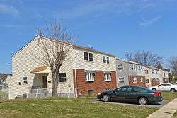 Apartments in the township | |
 Location in Delaware County and the state of Pennsylvania. | |
.svg.png) Location of Pennsylvania in the United States | |
| Coordinates: 39°51′00″N 75°19′59″W / 39.85000°N 75.33306°WCoordinates: 39°51′00″N 75°19′59″W / 39.85000°N 75.33306°W | |
| Country | United States |
| State | Pennsylvania |
| County | Delaware |
| Area[1] | |
| • Total | 1.43 sq mi (3.70 km2) |
| • Land | 1.43 sq mi (3.70 km2) |
| • Water | 0.00 sq mi (0.00 km2) |
| Elevation | 0 ft (0 m) |
| Population (2010) | |
| • Total | 3,940 |
| • Estimate (2016)[2] | 4,094 |
| • Density | 2,866.95/sq mi (1,106.82/km2) |
| Time zone | UTC-5 (EST) |
| • Summer (DST) | UTC-4 (EDT) |
| ZIP code | 19013 |
| Area code(s) | 610 and 484 |
| FIPS code | 42-045-13212 |
| FIPS code | 42-045-13212 |
| GNIS feature ID | 1216379 |
Chester Township is a township in Delaware County, Pennsylvania, United States. The population was 3,940 at the 2010 census,[3] down from 4,604 at the 2000 census.
History
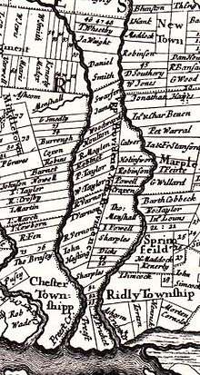
Chester Township is one of the first districts established after William Penn's first visit in 1682. The first record of Chester Township is in court documents from 1683 where a grand jury of seventeen people were "Impannelled to take out a Convenient Highway leading from Providence to Chester."[4]
During the American Revolutionary War, Chester township, which included the borough of Chester at the time, suffered greatly under the British Army. A list of the losses sustained was made and is preserved at the Historical Society of Pennsylvania.[5]
Geography
Chester Township is located in southern Delaware County at 39°50′43″N 75°23′37″W / 39.84528°N 75.39361°W (39.845411, -75.393857).[6] It is bordered to the south by the city of Chester, to the east by the borough of Upland, to the northeast by the borough of Brookhaven, to the north by Aston Township, and to the west by Upper Chichester Township.
According to the United States Census Bureau, the township has a total area of 1.4 square miles (3.7 km2), all land. Chester Creek, a southeast-flowing tributary of the Delaware River, flows through the township. Interstate 95 crosses the southern part of the township, intersecting U.S. Route 322 at Exit 4.
Demographics
| Historical population | |||
|---|---|---|---|
| Census | Pop. | %± | |
| 1930 | 2,073 | — | |
| 1940 | 1,988 | −4.1% | |
| 1950 | 3,547 | 78.4% | |
| 1960 | 3,602 | 1.6% | |
| 1970 | 5,708 | 58.5% | |
| 1980 | 5,687 | −0.4% | |
| 1990 | 5,399 | −5.1% | |
| 2000 | 4,604 | −14.7% | |
| 2010 | 3,940 | −14.4% | |
| Est. 2016 | 4,094 | [2] | 3.9% |
| [7] | |||
As of Census 2010, the racial makeup of the township was 16.9% White, 78.3% African American, 0.2% Native American, 0.5% Asian, 1.1% from other races, and 3.0% from two or more races. Hispanic or Latino of any race were 3.9% of the population .
As of the census[8] of 2000, there were 4,604 people, 1,641 households, and 1,188 families residing in the township. The population density was 3,301.7 people per square mile (1,278.9/km²). There were 1,754 housing units at an average density of 1,257.8 per square mile (487.2/km²). The racial makeup of the township was 22.72% White, 73.33% African American, 0.26% Native American, 0.59% Asian, 0.02% Pacific Islander, 0.96% from other races, and 2.13% from two or more races. 2.06% of the population were Hispanic or Latino of any race.
There were 1,641 households, out of which 39.7% had children under the age of 18 living with them, 35.1% were married couples living together, 30.8% had a female householder with no husband present, and 27.6% were non-families. 23.0% of all households were made up of individuals, and 5.8% had someone living alone who was 65 years of age or older. The average household size was 2.81 and the average family size was 3.31.
In the township the population was spread out, with 33.7% under the age of 18, 7.9% from 18 to 24, 29.5% from 25 to 44, 21.4% from 45 to 64, and 7.5% who were 65 years of age or older. The median age was 32 years. For every 100 females, there were 84.6 males. For every 100 womenage 18 and over, there were 75.6 men.
The median income for a household in the township was $32,576, and the median income for a family was $34,391. Males had a median income of $31,845 versus $25,286 for females. The per capita income for the township was $16,072. About 16.2% of families and 17.1% of the population were below the poverty line, including 24.0% of those under age 18 and 23.3% of those age 65 or over.
Education
Residents in Chester Township are zoned to the Chester-Upland School District. Toby Farms Elementary School is the public elementary school in Chester Township.[9] Residents are also zoned to Smedley Middle School and Chester High School.
Notable people
- Samuel Edwards - U.S. Congressman from Pennsylvania
References
- ↑ "2016 U.S. Gazetteer Files". United States Census Bureau. Retrieved Aug 13, 2017.
- 1 2 "Population and Housing Unit Estimates". Retrieved June 9, 2017.
- ↑ "Geographic Identifiers: 2010 Demographic Profile Data (G001): Chester township, Delaware County, Pennsylvania". U.S. Census Bureau, American Factfinder. Retrieved December 29, 2015.
- ↑ Ashmeade, Henry Graham (1884). History of Delaware County, Pennsylvania. Philadelphia: L.H. Everts & Co. p. 424. Retrieved 6 June 2017.
- ↑ Ashmeade, Henry Graham (1884). History of Delaware County, Pennsylvania. Philadelphia: L.H. Everts & Co. p. 426. Retrieved 6 June 2017.
- ↑ "US Gazetteer files: 2010, 2000, and 1990". United States Census Bureau. 2011-02-12. Retrieved 2011-04-23.
- ↑ http://www.dvrpc.org/data/databull/rdb/db82/appedixa.xls
- ↑ "American FactFinder". United States Census Bureau. Archived from the original on 2013-09-11. Retrieved 2008-01-31.
- ↑ "Mailing Address." Toby Farms Elementary School. Retrieved on March 30, 2009.
External links
Municipalities and communities of Delaware County, Pennsylvania, United States | ||
|---|---|---|
| City | 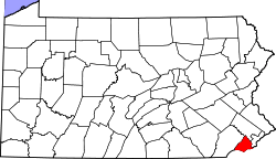 | |
| Boroughs | ||
| Townships | ||
| CDPs | ||
| Unincorporated communities |
| |
| Ghost town | ||
| Footnotes | ‡This populated place also has portions in an adjacent county or counties | |