Elverson, Pennsylvania
| Borough of Elverson | |
|---|---|
| Borough | |
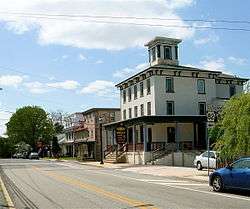 Intersection of Main Street (Rt. 23) and Chestnut Street (Rt. 82) | |
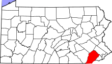
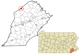 Location in Chester County and the U.S. state of Pennsylvania. | |
 Elverson Location of Elverson in Pennsylvania  Elverson Elverson (the US) | |
| Coordinates: 40°09′12″N 75°49′51″W / 40.15333°N 75.83083°WCoordinates: 40°09′12″N 75°49′51″W / 40.15333°N 75.83083°W | |
| Country | United States |
| State | Pennsylvania |
| County | Chester |
| Incorporated | April 17, 1911 |
| Area[1] | |
| • Total | 1.00 sq mi (2.60 km2) |
| • Land | 0.99 sq mi (2.57 km2) |
| • Water | 0.01 sq mi (0.03 km2) |
| Elevation | 669 ft (204 m) |
| Population (2010) | |
| • Total | 1,225 |
| • Estimate (2016)[2] | 1,311 |
| • Density | 1,318.91/sq mi (509.15/km2) |
| Time zone | UTC-5 (EST) |
| • Summer (DST) | UTC-4 (EDT) |
| ZIP Code | 19520 |
| Area code(s) | 610 and 484 |
| FIPS code | 42-23440 |
| Website | http://www.elversonboro.org |
Elverson is a borough in Chester County, Pennsylvania, United States. The population was 1,311 at the 2016 census.
Settled near the region's early iron mines, Elverson is close to Hopewell Furnace National Historic Site, an example of a 19th-century "iron plantation".
History
Elverson's earliest settlers arrived in the late 18th century when the area was known as Springfield. Later dubbed Blue Rock after a deposit of peculiar rocks not far from the town, it remained largely rural until the arrival of the Wilmington and Northern Railroad in 1870. By 1883, the town's population had more than doubled. In 1899, the settlement was named Elverson after James Elverson, owner of The Philadelphia Inquirer, who would later donate a stained glass window to a church there. The Borough of Elverson was officially incorporated on April 17, 1911, from land annexed from West Nantmeal Township, and it remained the commercial center of northwestern Chester County through the first half of the 20th century. In 1953 the borough annexed additional land, resulting in its current size of about one square mile.
Elverson's building styles follow the periods of its commercial growth and range from early 19th century stone or log buildings to post-railroad Queen Anne structures and 20th century craftsman and Foursquare-style houses. Commercial and residential development since the 1950s has occurred largely on the outskirts of the borough's historic center. The Wilmington and Northern Railroad line, later incorporated into the Reading Railroad system, was abandoned and removed in 1983.
The Elverson Historic District was listed on the National Register of Historic Places in 1993.[3]
Geography
According to the United States Census Bureau, the borough has a total area of 1.0 square mile (2.6 km2), all of it land. Elverson borders the Hopewell Big Woods. The city of Reading is approximately 18 miles (29 km) north of the borough.
Adjacent municipalities
- Caernarvon Township, Berks County - north
- West Nantmeal Township, Chester County - east, south, and west
Demographics
| Historical population | |||
|---|---|---|---|
| Census | Pop. | %± | |
| 1920 | 304 | — | |
| 1930 | 330 | 8.6% | |
| 1940 | 316 | −4.2% | |
| 1950 | 370 | 17.1% | |
| 1960 | 472 | 27.6% | |
| 1970 | 509 | 7.8% | |
| 1980 | 530 | 4.1% | |
| 1990 | 470 | −11.3% | |
| 2000 | 959 | 104.0% | |
| 2010 | 1,225 | 27.7% | |
| Est. 2016 | 1,311 | [2] | 7.0% |
| Sources:[4][5][6] | |||
At the 2010 census, the borough was 96.7% non-Hispanic White, 0.6% Black or African American, 0.1% Native American, 0.5% Asian, and 0.7% were two or more races. 1.6% of the population were of Hispanic or Latino ancestry .
As of the census[5] of 2000, there were 959 people, 412 households, and 313 families residing in the borough. The population density was 961.2 people per square mile (370.3/km²). There were 460 housing units at an average density of 461.1 per square mile (177.6/km²). The racial makeup of the borough was 97.08% White, 0.31% African American, 1.36% Asian, 0.42% from other races, and 0.83% from two or more races. Hispanic or Latino of any race were 0.63% of the population.
There were 412 households, out of which 21.4% had children under the age of 18 living with them, 68.2% were married couples living together, 5.6% had a female householder with no husband present, and 23.8% were non-families. 20.9% of all households were made up of individuals, and 5.8% had someone living alone who was 65 years of age or older. The average household size was 2.33 and the average family size was 2.68.
In the borough the population was spread out, with 17.7% under the age of 18, 4.1% from 18 to 24, 22.2% from 25 to 44, 32.1% from 45 to 64, and 23.9% who were 65 years of age or older. The median age was 50 years. For every 100 females there were 86.6 males. For every 100 females age 18 and over, there were 90.1 males.
The median income for a household in the borough was $57,813, and the median income for a family was $62,273. Males had a median income of $40,000 versus $31,953 for females. The per capita income for the borough was $27,162. About 0.6% of families and 1.8% of the population were below the poverty line, including none of those under age 18 and 3.9% of those age 65 or over.
Notable People
- Stone Librande a game designer was born in Elverson.
References
- ↑ "2016 U.S. Gazetteer Files". United States Census Bureau. Retrieved August 13, 2017.
- 1 2 "Population and Housing Unit Estimates". Retrieved June 9, 2017.
- ↑ National Park Service (2010-07-09). "National Register Information System". National Register of Historic Places. National Park Service.
- ↑ "Census of Population and Housing". U.S. Census Bureau. Archived from the original on May 12, 2015. Retrieved December 11, 2013.
- 1 2 "American FactFinder". United States Census Bureau. Archived from the original on September 11, 2013. Retrieved January 31, 2008.
- ↑ "Incorporated Places and Minor Civil Divisions Datasets: Subcounty Resident Population Estimates: April 1, 2010 to July 1, 2012". Population Estimates. U.S. Census Bureau. Archived from the original on June 17, 2013. Retrieved December 11, 2013.
External links
| Wikimedia Commons has media related to Elverson, Pennsylvania. |