Ebensburg, Pennsylvania
| Ebensburg, Pennsylvania | |
|---|---|
| Borough | |
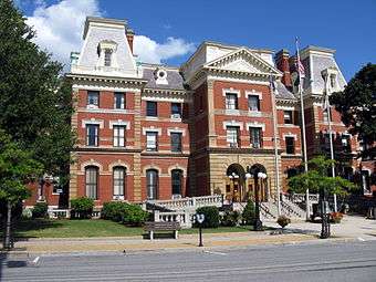 The Cambria County courthouse in Ebensburg | |
| Motto(s): Crossroads of Cambria | |
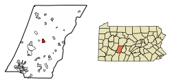 Location of Ebensburg in Cambria County, Pennsylvania. | |
 Ebensburg Location of Ebensburg in Cambria County, Pennsylvania. | |
| Coordinates: 40°29′11″N 78°43′32″W / 40.48639°N 78.72556°WCoordinates: 40°29′11″N 78°43′32″W / 40.48639°N 78.72556°W | |
| Country | United States |
| State | Pennsylvania |
| County | Cambria |
| Settled | 1796 |
| Incorporated | 1825 |
| Government | |
| • Type | Borough council |
| • Mayor | Randy Datsko |
| Area[1] | |
| • Total | 1.69 sq mi (4.37 km2) |
| • Land | 1.65 sq mi (4.28 km2) |
| • Water | 0.04 sq mi (0.09 km2) |
| Elevation | 2,140 ft (650 m) |
| Population (2010) | |
| • Total | 3,351 |
| • Estimate (2016)[2] | 3,166 |
| • Density | 1,915.31/sq mi (739.55/km2) |
| Time zone | UTC-5 (Eastern (EST)) |
| • Summer (DST) | UTC-4 (EDT) |
| ZIP code | 15931 |
| Area code(s) | 814 |
| FIPS code | 42-22144 |
| Website |
www |
Ebensburg is a borough and the county seat of Cambria County in the U.S. state of Pennsylvania.[3] It is located 25 miles (40 km) west of Altoona and surrounded by Cambria Township. It is situated in the Allegheny Mountains at about 2,140 feet (650 m) above sea level. Ebensburg is located in a rich bituminous coal region. In the past, sawmills, tanneries, wool mills, and a foundry operated there. The number of residents in 1900 was 1,574, and in 1910, 1,978. The population was 3,351 at the 2010 census.[4] It is part of the Johnstown, Pennsylvania Metropolitan Statistical Area.
History
Ebensburg originated in November 1796, when Congregational minister Rhees Lloyd led a small party of 20 Welsh people from Philadelphia to the lands Morgan John Rhees had chosen for his colony. They selected an attractive spot in the tops of the Allegheny Mountains and there settled what would become Ebensburg, naming it for Eben Lloyd, who died in childhood.[5] Lloyd offered land to the government in exchange for Ebensburg becoming the county seat, which the government accepted.
During the Civil War, men from Ebensburg served in the 133rd Pennsylvania Volunteer Infantry (particularly companies A, B and F)[6] and fought in Allabach’s brigade (Humphreys' 3rd Division) at Fredericksburg and Chancellorsville. In the Battle of Fredericksburg on December 13, 1862, the 133rd participated in the final charge on Marye’s Heights, suffering heavy losses.[7]
Education
In the borough of Ebensburg, there are three public and two private schools. The two private schools are Bishop Carroll High School and Holy Name Elementary. The public schools are Cambria High School, Central Cambria Middle School, and Cambria Elementary. The fourth school of the Central Cambria School District is located about 5 miles (8.0 km) west of the borough, off Route 22.
Geography
Ebensburg is located in the center of Cambria County at 40°29′11″N 78°43′32″W / 40.48639°N 78.72556°W (40.486388, -78.725461).[8]
Three U.S. highways pass intersect around Ebensburg. U.S. Route 22 runs along the southern border of the borough, leading east 18 miles (29 km) to Hollidaysburg, south of Altoona, and west 72 miles (116 km) to Pittsburgh. U.S. Route 219 bypasses the borough to the west, with access from two exits (U.S. 22 and U.S. 422). US 219 leads north 58 miles (93 km) to DuBois and south 41 miles (66 km) to Somerset. Finally, the western portion of U.S. Route 422 begins at US 219 on the west side of Ebensburg and leads west 26 miles (42 km) to the borough of Indiana. Johnstown, the largest city in Cambria County, is 22 miles (35 km) to the southwest via US 219 and Pennsylvania Route 56.
According to the United States Census Bureau, the borough of Ebensburg has a total area of 1.7 square miles (4.4 km2), of which 1.7 square miles (4.3 km2) is land and 0.04 square miles (0.1 km2), or 2.13%, is water.[4]
Demographics
| Historical population | |||
|---|---|---|---|
| Census | Pop. | %± | |
| 1810 | 75 | — | |
| 1820 | 168 | 124.0% | |
| 1830 | 270 | 60.7% | |
| 1840 | 353 | 30.7% | |
| 1850 | 600 | 70.0% | |
| 1860 | 1,002 | 67.0% | |
| 1870 | 1,240 | 23.8% | |
| 1880 | 1,123 | −9.4% | |
| 1890 | 1,202 | 7.0% | |
| 1900 | 1,574 | 30.9% | |
| 1910 | 1,978 | 25.7% | |
| 1920 | 2,179 | 10.2% | |
| 1930 | 3,063 | 40.6% | |
| 1940 | 3,719 | 21.4% | |
| 1950 | 4,086 | 9.9% | |
| 1960 | 4,111 | 0.6% | |
| 1970 | 4,318 | 5.0% | |
| 1980 | 4,096 | −5.1% | |
| 1990 | 3,872 | −5.5% | |
| 2000 | 3,091 | −20.2% | |
| 2010 | 3,351 | 8.4% | |
| Est. 2016 | 3,166 | [2] | −5.5% |
| Sources:[9][10][11] | |||
As of the census[10] of 2010, there were 3,351 people and 1,612 households within the borough. The population density was 1,971.2 people per square mile (702.0/km²). There were 1,742 housing units at an average density of 1,024.7 per square mile (334.8/km²). The racial make-up of the borough was 98.27% White, 0.48% African American, 0.69% Asian, 0.12% Native American, 0.01% from other races, and 0.36% from two or more races. Hispanic or Latino of any race were 0.48% of the population.
There were 1,612 households, out of which 22.7% had children under the age of 18 living with them, 48.3% were married couples living together, 9.1% had a female householder with no husband present, and 39.3% were non-families. 35.3% of all households were made up of individuals, and 17.3% had someone living alone who was 65 years of age or older. The average household size was 2.23 and the average family size was 2.90.
In the borough the population was spread out, with 19.2% under the age of 18, 1.9% from 18 to 19, 6.4% from 20 to 24, 12.9% from 25 to 34, 17.4% from 35 to 49, 21.7% from 50 to 64, and 20.5% who were 65 years of age or older. The median age was 42 years. The population was 46.55% male, and 53.45% female.
Notable people
- Alan Baylock, jazz composer, band leader, chief arranger, US Air Force Airmen of Note[12]
- Bill Hartack, Hall of Fame jockey
- William Pryce, U.S. Ambassador to Honduras
References
- ↑ "2016 U.S. Gazetteer Files". United States Census Bureau. Retrieved Aug 13, 2017.
- 1 2 "Population and Housing Unit Estimates". Retrieved June 9, 2017.
- ↑ "Find a County". National Association of Counties. Archived from the original on 2012-07-12. Retrieved 2011-06-07.
- 1 2 "Geographic Identifiers: 2010 Demographic Profile Data (G001): Ebensburg borough, Pennsylvania". U.S. Census Bureau, American Factfinder. Retrieved March 12, 2015.
- ↑ "Profile for Ebensburg, Pennsylvania". ePodunk. Retrieved 2010-06-12.
- ↑ "133rd Pennsylvania Volunteers, Company C Muster Roll". www.pa-roots.com. Retrieved 2016-03-14.
- ↑ "Civil War Index - 133rd Pennsylvania Infantry". www.civilwarindex.com. Retrieved 2016-03-14.
- ↑ "US Gazetteer files: 2010, 2000, and 1990". United States Census Bureau. 2011-02-12. Retrieved 2011-04-23.
- ↑ "Census of Population and Housing". U.S. Census Bureau. Archived from the original on 12 May 2015. Retrieved 11 December 2013.
- 1 2 "American FactFinder". United States Census Bureau. Archived from the original on 2013-09-11. Retrieved 2008-01-31.
- ↑ "Incorporated Places and Minor Civil Divisions Datasets: Subcounty Resident Population Estimates: April 1, 2010 to July 1, 2012". Population Estimates. U.S. Census Bureau. Archived from the original on 17 June 2013. Retrieved 11 December 2013.
- ↑
External links
Municipalities and communities of Cambria County, Pennsylvania, United States | ||
|---|---|---|
| City | 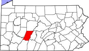 | |
| Boroughs |
| |
| Townships | ||
| CDPs | ||
| Unincorporated communities | ||
| Footnotes | ‡This populated place also has portions in an adjacent county or counties | |