Chalfont, Pennsylvania
| Borough of Chalfont | ||
|---|---|---|
| home rule municipality | ||
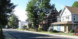 Main Street in Chalfont. | ||
| ||
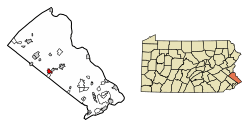 Location of Chalfont in Bucks County, Pennsylvania. | ||
 Chalfont Location of Chalfont in Pennsylvania  Chalfont Chalfont (the US) | ||
| Coordinates: 40°17′23″N 75°12′37″W / 40.28972°N 75.21028°WCoordinates: 40°17′23″N 75°12′37″W / 40.28972°N 75.21028°W | ||
| Country | United States | |
| State | Pennsylvania | |
| County | Bucks | |
| Purchased | 1683 | |
| Government | ||
| • Mayor | Marilyn J. Becker | |
| Area[1] | ||
| • Total | 1.64 sq mi (4.24 km2) | |
| • Land | 1.62 sq mi (4.19 km2) | |
| • Water | 0.02 sq mi (0.05 km2) | |
| Elevation | 272 ft (83 m) | |
| Population (2010) | ||
| • Total | 4,009 | |
| • Estimate (2016)[2] | 4,047 | |
| • Density | 2,501.24/sq mi (965.49/km2) | |
| Time zone | UTC-5 (Eastern (EST)) | |
| • Summer (DST) | UTC-4 (EDT) | |
| ZIP code | 18914 | |
| Area code(s) | 215 and 267 | |
| FIPS code | 42-12504 | |
| Website |
www | |
Chalfont is a borough with home rule status in Bucks County, Pennsylvania, United States. The population was 4,009 at the 2010 census. The borough is served by SEPTA Regional Rail's Lansdale/Doylestown Line at Chalfont station.
Chalfont is named after Chalfont St Giles in Buckinghamshire, England. Chalfont was the home of William Penn's first wife, and William Penn is buried at Jordans Quaker Meeting House near Chalfont St Giles.
The Chalfont Historic District is listed on the National Register of Historic Places and contains many American colonial and Victorian-style houses. Several of these are former residences which are currently occupied by businesses and are concentrated near the intersection of Butler Avenue (U.S. Route 202 Business) and North Main Street (Pennsylvania Route 152) and extend along North Main Street.
Chalfont is located within the Delaware Valley.
Geography
Chalfont is located at 40°17′23″N 75°12′37″W / 40.28972°N 75.21028°W (40.289739, −75.210241).[3]
Natural features
Neshaminy Creek and Pine Run pass through Chalfont.[4]
According to the United States Census Bureau, the borough has a total area of 1.6 square miles (4.3 km²), all of it land.
Demographics
| Historical population | |||
|---|---|---|---|
| Census | Pop. | %± | |
| 1880 | 216 | — | |
| 1910 | 303 | — | |
| 1920 | 317 | 4.6% | |
| 1930 | 550 | 73.5% | |
| 1940 | 670 | 21.8% | |
| 1950 | 828 | 23.6% | |
| 1960 | 1,410 | 70.3% | |
| 1970 | 2,366 | 67.8% | |
| 1980 | 2,802 | 18.4% | |
| 1990 | 3,069 | 9.5% | |
| 2000 | 3,900 | 27.1% | |
| 2010 | 4,009 | 2.8% | |
| Est. 2016 | 4,047 | [2] | 0.9% |
| Sources:[5][6][7] | |||
As of the 2010 census, the borough was 92.7% Non-Hispanic White, 1.4% Black or African American, 0.3% Native American, 3.0% Asian, and 0.8% were two or more races. 1.7% of the population were of Hispanic or Latino ancestry .
As of the census[6] of 2000, there were 3,977 people, 1,382 households, and 1,039 families residing in the borough. The population density was 2,365.8 people per square mile (912.6/km²). There were 1,404 housing units at an average density of 851.7 per square mile (328.5/km²). The racial makeup of the borough was 95.56% White, 1.15% African American, 0.08% Native American, 1.49% Asian, 0.05% from other races, and 0.77% from two or more races. Hispanic or Latino of any race were 1.25% of the population.
There were 1,382 households, out of which 40.1% had children under the age of 18 living with them, 66.2% were married couples living together, 6.9% had a female householder with no husband present, and 24.8% were non-families. 19.6% of all households were made up of individuals, and 4.8% had someone living alone who was 65 years of age or older. The average household size was 2.78 and the average family size was 3.25.
In the borough the population was spread out, with 29.1% under the age of 18, 5.5% from 18 to 24, 34.9% from 25 to 44, 21.9% from 45 to 64, and 8.6% who were 65 years of age or older. The median age was 36 years. For every 100 females, there were 96.9 males. For every 100 females age 18 and over, there were 94.4 males.
The median income for a household in the borough was $63,491, and the median income for a family was $70,592. Males had a median income of $51,139 versus $30,842 for females. The per capita income for the borough was $26,248. About 1.1% of families and 4.1% of the population were below the poverty line, including 1.4% of those under age 18 and 3.2% of those age 65 or over.
Climate
During the summer months, frequent episodes of high humidity occur. Occasionally, heat index values exceed 100 °F (38 °C). On average, the wettest month of the year is July which corresponds with the annual peak for thunderstorm activity. During the winter months, wind chill values occasionally fall below 0 °F (-18 °C). On average, the snowiest month of the year is February which corresponds with the annual peak for nor'easter activity.
| Climate data for Chalfont Borough, Pennsylvania (1981 – 2010 averages). Elevation 277 ft (84 m). | |||||||||||||
|---|---|---|---|---|---|---|---|---|---|---|---|---|---|
| Month | Jan | Feb | Mar | Apr | May | Jun | Jul | Aug | Sep | Oct | Nov | Dec | Year |
| Average high °F (°C) | 39.2 (4) |
42.4 (5.8) |
50.8 (10.4) |
62.8 (17.1) |
72.9 (22.7) |
81.6 (27.6) |
85.7 (29.8) |
84.1 (28.9) |
77.2 (25.1) |
65.8 (18.8) |
54.7 (12.6) |
43.3 (6.3) |
63.4 (17.4) |
| Average low °F (°C) | 21.7 (−5.7) |
24.1 (−4.4) |
30.9 (−0.6) |
40.4 (4.7) |
49.8 (9.9) |
59.5 (15.3) |
64.4 (18) |
62.9 (17.2) |
55.1 (12.8) |
43.0 (6.1) |
34.7 (1.5) |
26.3 (−3.2) |
42.7 (5.9) |
| Average precipitation inches (mm) | 3.29 (83.6) |
2.67 (67.8) |
3.77 (95.8) |
3.95 (100.3) |
4.32 (109.7) |
4.25 (108) |
4.93 (125.2) |
4.08 (103.6) |
4.46 (113.3) |
4.13 (104.9) |
3.63 (92.2) |
3.94 (100.1) |
47.42 (1,204.5) |
| Average snowfall inches (cm) | 8.8 (22.4) |
9.8 (24.9) |
4.2 (10.7) |
0.8 (2) |
0.0 (0) |
0.0 (0) |
0.0 (0) |
0.0 (0) |
0.0 (0) |
0.0 (0) |
0.6 (1.5) |
4.3 (10.9) |
28.5 (72.4) |
| Source: PRISM [8] | |||||||||||||
History
Originally, the Lenape Indians dwelled in present-day Chalfont. In 1683, William Penn signed a treaty with the local chief and parceled the land to the Free Society of Traders. In 1720, Simon Butler bought over 150 acres of land, including the "Village of Chalfont." After the construction of his home and mill, Butler bought more than 400 more acres of land. Butler was a giant historical figure who acted as a legal and economic powerhouse in the area. After his death, the land was parceled to a number of people. Since then and 1901, Chalfont has been named a number of things including Butler's Mill, Kungle's Tavern, Barndtsville, and Whitehallville. For many years, the most important building in the area was the tavern and public house, which has burnt down many times and now stands as Borghi's Restaurant. During the Victorian era, a train-station was built which helped the community grow and brought about the construction of the many Victorian houses.
In 1885, Chalfont established Forest Park. Forest park started out as a small picnic ground where music could be played. The appearance of the train station in Chalfont assured the park's success. However, as the park grew it became a small amusement park where local people could enjoy rides, a large swimming pool built in the 1930s, music (including string bands in the 1940s) and as the hosting ground for many company picnics. The park closed its doors forever in 1968.[9]
Notable people
Bobby Shantz, 1952 American League Most Valuable Player, operated a popular bowling alley and diner with baseball players Joe Astroth and Shantz’s brother, Billy Shantz. The Pit-Catcher, aptly named after the combination of Bobby’s career as baseball pitcher and Joe & Billy’s careers as catchers, was a popular meeting place for Chalfont residents of all ages. The Pit-Catcher displayed Bobby’s golden gloves, MVP trophy, and other baseball memorabilia.
References
- ↑ "2016 U.S. Gazetteer Files". United States Census Bureau. Retrieved Aug 13, 2017.
- 1 2 "Population and Housing Unit Estimates". Retrieved June 9, 2017.
- ↑ "US Gazetteer files: 2010, 2000, and 1990". United States Census Bureau. 2011-02-12. Retrieved 2011-04-23.
- ↑ MacReynolds, George, Place Names in Bucks County, Pennsylvania, Doylestown, Bucks County Historical Society, Doylestown, PA, 1942
- ↑ "Census of Population and Housing". U.S. Census Bureau. Archived from the original on May 12, 2015. Retrieved 11 December 2013.
- 1 2 "American FactFinder". United States Census Bureau. Archived from the original on September 11, 2013. Retrieved 2008-01-31.
- ↑ "Incorporated Places and Minor Civil Divisions Datasets: Subcounty Resident Population Estimates: April 1, 2010 to July 1, 2012". Population Estimates. U.S. Census Bureau. Archived from the original on June 17, 2013. Retrieved 11 December 2013.
- ↑ "PRISM Climate Group, Oregon State U". prism.oregonstate.edu. Retrieved April 20, 2018.
- ↑ A History of Chalfont (1977) by the Chalfont Borough Bicentennial Committee
External links
| Wikivoyage has a travel guide for Chalfont. |
- Chalfont Borough official website
