Kittanning, Pennsylvania
| Kittanning, Pennsylvania | |
|---|---|
| Borough | |
| Borough of Kittanning | |
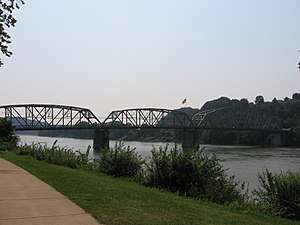
 The Kittanning Citizens Bridge, Armstrong County Courthouse, and downtown of Kittanning | |
| Etymology: Lenape kithanink, 'on the main river' | |
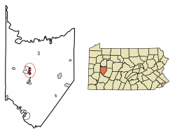 Location of Kittanning in Armstrong County, Pennsylvania. | |
.svg.png) Location of Pennsylvania in the United States | |
| Coordinates: 40°49′12″N 79°31′17″W / 40.82000°N 79.52139°WCoordinates: 40°49′12″N 79°31′17″W / 40.82000°N 79.52139°W | |
| Country | United States |
| State | Pennsylvania |
| County | Armstrong County |
| Settled | 1724 (Native American village) |
| Settled | 1803 (Borough) |
| Area[1] | |
| • Total | 1.25 sq mi (3.24 km2) |
| • Land | 1.00 sq mi (2.58 km2) |
| • Water | 0.25 sq mi (0.66 km2) |
| Population (2010) | |
| • Total | 4,044 |
| • Estimate (2016)[2] | 3,846 |
| • Density | 3,861.45/sq mi (1,490.40/km2) |
| Time zone | UTC-5 (EST) |
| • Summer (DST) | UTC-4 (EDT) |
| ZIP code | 16201 |
| Area code(s) | 724 |
| FIPS code | 42-40040 |
| School district | Armstrong |
Kittanning (/kɪˈtænɪŋ/ pronounced k-TAN-ing) is a borough and the county seat of Armstrong County in the U.S. state of Pennsylvania.[3] It is situated 44 miles (71 km) northeast of Pittsburgh, along the east bank of the Allegheny River.
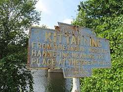
The name is derived from Kithanink,[4] which means 'on the main river' in Lenape or the Delaware language, from kit- 'big' + hane 'mountain river' + -ink (suffix used in place names). "The main river" is a Lenape term for the Allegheny and Ohio combined, which they considered as all one river.[5] The borough and its bridge have been used as a setting for several recent films.
History
The borough is located on the east bank of the Allegheny River, founded on the site of the eighteenth-century Lenape (Delaware) village of Kittanning at the western end of the Kittanning Path, an ancient Native American path.
In 1756, the village was destroyed by John Armstrong, Sr. at the Battle of Kittanning during the French and Indian War. During the attack, a blast from the explosion of gunpowder stored in Captain Jacobs's house was heard in Pittsburgh, Pennsylvania, 44 miles away.
Kittanning was designated as the seat of Armstrong County when the county was organized. It was settled by European Americans largely after the American Revolutionary War, although Anthony Sadowski (also recorded by the anglicized name of Sandusky), a prominent Polish-American trader, and other Indian traders operated here before the war.
By the early in the 20th century, the city had developed considerable industry: large iron and steel works, foundries, and coal mines, all associated with the steel and iron industries of Pittsburgh; glassworks, flour and lumber mills; china, pottery, brick, lime, and clay works; and mirror and typewriter factories, breweries, etc. It reached its peak of population in 1930 and was adversely affected by the Great Depression. After World War II, changes in industry and restructuring of heavy industry caused a loss of jobs in many of these works, with an associated population decline.
The playground on North Jefferson Street was developed on the former site of the historic Kittanning Cemetery. In order to enable this, the city moved 274 graves in 1960 to a new cemetery formed along Troy Hill Road.
In 1900, 3,902 people lived in Kittanning, and in 1910, there were 4,311 inhabitants. After Kittanning merged with Wickboro (1910 population 2,775), in 1914, the population was estimated at 10,000, which was likely high. The 1920 census counted 7,153 residents. In 1930, there were 7,808 residents; in 1940, 7,550. Since late 20th century industrial restructuring, the population was 4,044 at the 2010 census. [3]
The Allegheny River Lock and Dam No. 7 and Armstrong County Courthouse and Jail are each listed on the National Register of Historic Places.[6]
Geography
Kittanning is located at 40°49′12″N 79°31′17″W / 40.82000°N 79.52139°W (40.820085, -79.521398).[7] According to the United States Census Bureau, the borough has a total area of 1.0 square mile (2.6 km2), all land.
Demographics
| Historical population | |||
|---|---|---|---|
| Census | Pop. | %± | |
| 1820 | 318 | — | |
| 1830 | 526 | 65.4% | |
| 1850 | 1,561 | — | |
| 1860 | 1,696 | 8.6% | |
| 1870 | 1,889 | 11.4% | |
| 1880 | 2,624 | 38.9% | |
| 1890 | 3,095 | 17.9% | |
| 1900 | 3,902 | 26.1% | |
| 1910 | 4,311 | 10.5% | |
| 1920 | 7,153 | 65.9% | |
| 1930 | 7,808 | 9.2% | |
| 1940 | 7,550 | −3.3% | |
| 1950 | 7,731 | 2.4% | |
| 1960 | 6,793 | −12.1% | |
| 1970 | 6,231 | −8.3% | |
| 1980 | 5,432 | −12.8% | |
| 1990 | 5,120 | −5.7% | |
| 2000 | 4,787 | −6.5% | |
| 2010 | 4,044 | −15.5% | |
| Est. 2016 | 3,846 | [2] | −4.9% |
| Sources:[8][9][10] | |||
As of the census[9] of 2000, there were 4,787 people, 2,032 households, and 1,117 families residing in the borough. The population density was 4,615.2 people per square mile (1,777.2/km²). There were 2,251 housing units at an average density of 2,170.2 per square mile (835.7/km²). The racial makeup of the borough was 97.31% White, 1.57% African American, 0.23% Native American, 0.25% Asian, 0.08% from other races, and 0.56% from two or more races. Hispanic or Latino of any race were 0.67% of the population.
There were 2,032 households, out of which 26.2% had children under the age of 18 living with them, 36.7% were married couples living together, 14.9% had a female householder with no husband present, and 45.0% were non-families. 40.5% of all households were made up of individuals, and 19.4% had someone living alone who was 65 years of age or older. The average household size was 2.19 and the average family size was 2.96.
In the borough the population was spread out, with 22.2% under the age of 18, 10.4% from 18 to 24, 27.1% from 25 to 44, 20.3% from 45 to 64, and 20.1% who were 65 years of age or older. The median age was 40 years. For every 100 females, there were 82.5 males. For every 100 females age 18 and over, there were 78.2 males.
The median income for a household in the borough was $20,921, and the median income for a family was $30,822. Males had a median income of $29,036 versus $20,040 for females. The per capita income for the borough was $13,787. About 12.3% of families and 16.4% of the population were below the poverty line, including 14.8% of those under age 18 and 11.7% of those age 65 or over.
Electricity
Education
All public schools in the Kittanning attendance area are a part of the Armstrong School District.
Media
Newspapers
- Leader Times
- The Kittanning Paper [11]
Radio
- WTYM AM 1380
Television
- Family-Life TV (Public-access television cable TV)[12]
In popular culture
Several popular movies and televisions programs have been filmed in Kittanning.
The original bridge over the Allegheny River at Kittanning was torn down and replaced with the Kittanning Citizens Bridge, which was built higher above ground level to avoid flooding. Scenes with the town and bridge were the used in the film The Mothman Prophecies (2002) starring Richard Gere and Laura Linney, which was filmed in the Kittanning area.
Scenes for the 2009 horror movie My Bloody Valentine 3D were filmed in Kittanning.[13]
The 2010 pilot episode for Justified, starring Timothy Olyphant, was filmed in Kittanning and its surrounding areas.[14]
Filming for the movie One for the Money took place during Summer 2010.[15]
The setting for three episodes of the Netflix original TV series Mindhunter is based in Altoona, but scenes were actually shot in and around Kittanning in January 2017. [16]
Notable people
- Jason Altmire, U.S. Congressman
- Mitch Frerotte, NFL player [17]
- Daniel Brodhead Heiner, U.S. Representative from Pennsylvania[18]
- Ed Hobaugh, baseball player[19]
- Teri Hope, actress and Playboy Playmate[20]
- Mickey Morandini, Baseball Player [21]
- Ralph Patt, jazz guitarist
- Jack Lambert, NFL player
- Chad Reesman, Hall of Fame Fantasy Football Player
- Dick Starr, major league pitcher
- George L. Shoup, First governor of Idaho, United States senator
See also
References
- ↑ "2016 U.S. Gazetteer Files". United States Census Bureau. Retrieved Aug 13, 2017.
- 1 2 "Population and Housing Unit Estimates". Retrieved June 9, 2017.
- 1 2 "Find a County". National Association of Counties. Archived from the original on 2011-05-31. Retrieved 2011-06-07.
- ↑ "kithanink". Lenape Talking Dictionary. Archived from the original on 2012-03-15. Retrieved 2012-06-11.
- ↑ Smith, Robert Walker (1883). History of Armstrong County, Pennsylvania. Chicago: Waterman, Watkins, & Co.
- ↑ National Park Service (2010-07-09). "National Register Information System". National Register of Historic Places. National Park Service.
- ↑ "US Gazetteer files: 2010, 2000, and 1990". United States Census Bureau. 2011-02-12. Retrieved 2011-04-23.
- ↑ "Census of Population and Housing". U.S. Census Bureau. Archived from the original on 12 May 2015. Retrieved 11 December 2013.
- 1 2 "American FactFinder". United States Census Bureau. Retrieved 2008-01-31.
- ↑ "Incorporated Places and Minor Civil Divisions Datasets: Subcounty Resident Population Estimates: April 1, 2010 to July 1, 2012". Population Estimates. U.S. Census Bureau. Archived from the original on 17 June 2013. Retrieved 11 December 2013.
- ↑ The Kittanning Paper
- ↑ Family-Life TV
- ↑ Fryer, Mitch (2008-04-30). "Producers, crew scout area for horror film". Leader Times. The Tribune-Review Publishing Co. Archived from the original on 2008-06-09. Retrieved 2009-04-05.
- ↑ Owen, Rob (January 18, 2010). "Producer of FX's 'Justified' recalls 'boom' times here". Pittsburgh Post-Gazette.
- ↑ Signorini, Renatta (2010-08-31). "Cameras roll, traffic slows as filming on Kittanning Citizens Bridge starts". Leader Times. Trib Total Media. Archived from the original on 2012-09-11. Retrieved 2010-08-31.
- ↑ Weaver, Jonathan (2017-01-14). ""Mindhunter" Puts Spotlight on Kittanning for Netflix". The Kittanning Paper.
- ↑ "Mitch Frerotte". Pro-Football-Reference.Com. Retrieved December 21, 2012.
- ↑ "HEINER, Daniel Brodhead, (1854 - 1944)". Biographical Directory of the United States Congress. Retrieved December 21, 2012.
- ↑ "Ed Hobaugh Stats". Baseball Almanac. Retrieved December 21, 2012.
- ↑ "Teri Hope, Native Girl, Comes Home". Pittsburgh Post-Gazette. 1961-11-28. Retrieved October 28, 2012.
- ↑ "Michael Robert Morandini". Baseball-Reference.Com. Retrieved December 21, 2012.
| Wikimedia Commons has media related to Kittanning, Pennsylvania. |
External links
- Armstrong County Tourist Bureau website
- Carl's Kittanning.com website "since 1997"
- Downtown Kittanning Walking Tour as a photo essay.
- Kittanning Online – history of Kittanning and social networking site
Municipalities and communities of Armstrong County, Pennsylvania, United States | ||
|---|---|---|
| City | 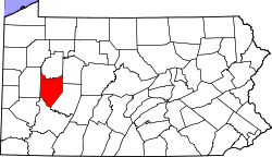 | |
| Boroughs | ||
| Townships | ||
| CDPs | ||
| Unincorporated communities | ||
| Counties |  Map of the Pittsburgh Tri-State with green counties in the metropolitan area and yellow counties in the combined area. | |
|---|---|---|
| Major cities | ||
| Cities and towns 15k-50k (in 2010) | ||
| Airports | ||
| Topics | ||
| ||