Mifflin County, Pennsylvania
| Mifflin County, Pennsylvania | |
|---|---|
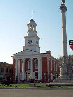 former Mifflin County Courthouse | |
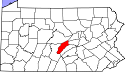 Location in the U.S. state of Pennsylvania | |
 Pennsylvania's location in the U.S. | |
| Founded | September 19, 1789 |
| Named for | Thomas Mifflin |
| Seat | Lewistown |
| Largest borough | Lewistown |
| Area | |
| • Total | 415 sq mi (1,075 km2) |
| • Land | 411 sq mi (1,064 km2) |
| • Water | 3.7 sq mi (10 km2), 0.9% |
| Population (est.) | |
| • (2017) | 46,388 |
| • Density | 113/sq mi (44/km2) |
| Congressional district | 10th |
| Time zone | Eastern: UTC−5/−4 |
| Website |
www |
Mifflin County is a county located in the U.S. state of Pennsylvania. As of the 2010 census, the population was 46,682.[1] Its county seat is Lewistown.[2] The county was created on September 19, 1789, from parts of Cumberland County and Northumberland County and named after Thomas Mifflin, the first Governor of Pennsylvania.
Mifflin County comprises the Lewistown, PA Micropolitan Statistical Area.
Geography
According to the U.S. Census Bureau, the county has a total area of 415 square miles (1,070 km2), of which 411 square miles (1,060 km2) is land and 3.7 square miles (9.6 km2) (0.9%) is water.[3]
Mifflin County is located in, and has its boundaries defined by, the Ridge-and Valley Appalachian Mountains of Pennsylvania. US Route 322, a major divided highway, connects the county to the rest of the state on its route between Harrisburg and State College. US Route 522 also connects the county to the rest of the state on its route between Selinsgrove and Mount Union.
Adjacent counties
- Centre County (north)
- Union County (northeast)
- Snyder County (east)
- Juniata County (south)
- Huntingdon County (west)
Major Highways
Demographics
| Historical population | |||
|---|---|---|---|
| Census | Pop. | %± | |
| 1790 | 7,562 | — | |
| 1800 | 13,609 | 80.0% | |
| 1810 | 12,132 | −10.9% | |
| 1820 | 16,618 | 37.0% | |
| 1830 | 21,690 | 30.5% | |
| 1840 | 13,092 | −39.6% | |
| 1850 | 14,980 | 14.4% | |
| 1860 | 16,340 | 9.1% | |
| 1870 | 17,508 | 7.1% | |
| 1880 | 19,577 | 11.8% | |
| 1890 | 19,996 | 2.1% | |
| 1900 | 23,160 | 15.8% | |
| 1910 | 27,785 | 20.0% | |
| 1920 | 31,439 | 13.2% | |
| 1930 | 40,335 | 28.3% | |
| 1940 | 42,993 | 6.6% | |
| 1950 | 43,691 | 1.6% | |
| 1960 | 44,348 | 1.5% | |
| 1970 | 45,268 | 2.1% | |
| 1980 | 46,908 | 3.6% | |
| 1990 | 46,197 | −1.5% | |
| 2000 | 46,486 | 0.6% | |
| 2010 | 46,682 | 0.4% | |
| Est. 2017 | 46,388 | [4] | −0.6% |
| U.S. Decennial Census[5] 1790-1960[6] 1900-1990[7] 1990-2000[8] 2010-2013[1] | |||
As of the census[9] of 2010, there were 46,682 people and 18,743 households within the county. The population density was 112.5 people per square mile (44/km²). There were 21,537 housing units at an average density of 51.9 per square mile (19/km²). The racial makeup of the county was 97.53% White, 0.64% Black or African American, 0.11% Native American, 0.36% Asian, 0.01% Pacific Islander, 0.31% from other races, and 1.03% from two or more races. 1.14% of the population were Hispanic or Latino of any race. 38.8% were of German, 19.2% American, 8.0% Irish and 7.5% English ancestry according to Census 2000. 5.7% report speaking Pennsylvania German, Dutch, or German at home.
There were 18,743 households out of which 29.1% had children under the age of 18 living with them, 57.60% were married couples living together, 8.50% had a female householder with no husband present, and 29.90% were non-families. 26.00% of all households were made up of individuals and 13.20% had someone living alone who was 65 years of age or older. The average household size was 2.49 and the average family size was 2.99.
In the county, the population was spread out with 23.1% under the age of 18, 2.2% from 18 to 19, 5.1% from 20 to 24, 10.4% from 25 to 34, 20.1% from 35 to 49, 20.6% from 50 to 64, and 18.5% who were 65 years of age or older. The median age was 39 years. The population was 48.93% male, and 51.07% female.
Amish community
The Amish community in Mifflin County established in 1791, had a total population of 3,905 people (in 30 congregations) in 2017,[10] or 8.5% of the county's population.
Dialect
The dominant form of speech in Mifflin County is the Central Pennsylvania accent. Almost everyone in Mifflin County speaks English. The Amish and some Mennonites speak Pennsylvania German also known as Pennsylvania Dutch, a West Central German dialect, which is quite different from modern Standard German. The Amish and Mennonites also can speak English. Few non-Amish or Mennonites in Mifflin County today speak Pennsylvania German, but this was not true in the past.
Micropolitan Statistical Area
The United States Office of Management and Budget[11] has designated Mifflin County as the Lewistown, PA Micropolitan Statistical Area (µSA).[12] As of the 2010 U.S. Census[13] the micropolitan area ranked 10th most populous in the State of Pennsylvania and the 237th most populous in the United States with a population of 46,682.
Law and government
County Commissioners
| Year | Republican | Democratic | Third Parties |
|---|---|---|---|
| 2016 | 75.3% 14,094 | 20.7% 3,877 | 4.0% 750 |
| 2012 | 72.7% 11,939 | 26.0% 4,273 | 1.2% 204 |
| 2008 | 65.9% 10,929 | 32.4% 5,375 | 1.7% 283 |
| 2004 | 69.8% 11,726 | 29.1% 4,889 | 1.1% 187 |
| 2000 | 64.3% 9,400 | 33.1% 4,835 | 2.6% 379 |
| 1996 | 50.2% 6,888 | 38.8% 5,327 | 11.0% 1,503 |
| 1992 | 42.9% 6,300 | 33.7% 4,946 | 23.4% 3,442 |
| 1988 | 62.5% 8,170 | 36.6% 4,790 | 0.9% 115 |
| 1984 | 63.4% 9,106 | 36.0% 5,178 | 0.6% 89 |
| 1980 | 55.8% 7,541 | 38.7% 5,226 | 5.6% 753 |
| 1976 | 54.6% 7,698 | 44.0% 6,210 | 1.4% 201 |
| 1972 | 72.1% 9,989 | 26.5% 3,667 | 1.4% 199 |
| 1968 | 55.3% 8,133 | 38.7% 5,681 | 6.0% 884 |
| 1964 | 40.4% 6,006 | 59.3% 8,811 | 0.3% 39 |
| 1960 | 67.9% 10,315 | 31.7% 4,816 | 0.5% 72 |
| 1956 | 62.9% 8,638 | 37.0% 5,078 | 0.1% 9 |
| 1952 | 59.2% 8,620 | 40.5% 5,889 | 0.3% 47 |
| 1948 | 53.8% 5,666 | 45.3% 4,762 | 0.9% 95 |
| 1944 | 51.9% 6,205 | 47.6% 5,693 | 0.5% 54 |
| 1940 | 47.5% 6,352 | 52.3% 6,993 | 0.3% 34 |
| 1936 | 41.6% 6,867 | 58.0% 9,581 | 0.5% 77 |
| 1932 | 59.0% 5,525 | 39.0% 3,654 | 2.1% 193 |
| 1928 | 87.0% 8,932 | 12.4% 1,270 | 0.7% 68 |
| 1924 | 66.9% 4,780 | 28.0% 1,999 | 5.1% 364 |
| 1920 | 58.9% 3,872 | 36.5% 2,400 | 4.6% 299 |
| 1916 | 47.4% 2,105 | 44.2% 1,965 | 8.4% 374 |
| 1912 | 14.6% 654 | 31.3% 1,400 | 54.2% 2,426 |
| 1908 | 59.4% 2,902 | 36.8% 1,799 | 3.8% 185 |
| 1904 | 66.1% 3,054 | 29.8% 1,378 | 4.1% 188 |
| 1900 | 56.5% 2,594 | 40.1% 1,842 | 3.4% 157 |
| 1896 | 54.2% 2,662 | 41.8% 2,052 | 4.0% 196 |
| 1892 | 49.8% 2,175 | 46.5% 2,029 | 3.7% 162 |
| 1888 | 51.5% 2,321 | 46.2% 2,084 | 2.3% 105 |
- Stephen T. Dunkle (R)
- Rob Postal (R)
- Kevin P. Kodish (D)
In August 2016, then County Commissioner Lisa Nancollas, a Tea Party Republican, came under fire for anti-Islamic rhetoric posted to her campaign's Facebook account.[15] She would later go on to resign from her position, in April 2017, being replaced by Rob Postal.[16][17]
State House of Representatives[18]
- Rich Irvin, Republican, Pennsylvania's 81th Representative District
- Adam Harris, Republican, Pennsylvania's 82th Representative District
- Kerry A. Benninghoff, Republican, Pennsylvania's 171th Representative District
State Senate[18]
- Jake Corman, Republican, Pennsylvania's 34th Senatorial District
United States House of Representatives
- Tom Marino, Republican, Pennsylvania's 10th congressional district
United States Senate
Economy
Major employers in Mifflin County include:
Education
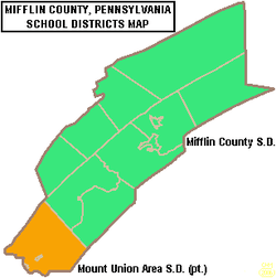
Public school districts
Most of the county is served by the Mifflin County School District, with the exception of Wayne Township and the boroughs of Newton-Hamilton and Kistler, which are part of the Mount Union Area School District.
- Mifflin County School District
- Mount Union Area School District (also in Huntingdon County)
Head Start preschool programs
Head Start is a federally and state funded preschool program for low income children. The program serves 3- and 4-year-olds. In order to participate the family income must be below federal poverty guidelines.
- Coleman Head Start Center[19]
- McVeytown Head Start Center
Private schools
- Sacred Heart provides a private, Catholic education until fifth grade.
- Belleville Mennonite School, Beth-El Christian Day School, and Valley View Christian School provide Mennonite education through grade twelve.
- Mifflin County Christian Academy located in Decatur Township provides Christian education from kindergarten through grade twelve as well as day care.
- Several Old Order Amish schools provide education through grade eight.
Colleges and universities
Mifflin-Juniata Career and Technology Center located in Lewistown provides post high school degrees in nursing, auto mechanics and electrical services and numerous other technology driven careers.
The Lewistown branch of the South Hills School of Business and Technology offers associate degrees and other certifications in various areas of business, technology, and some health care.
The Penn State Learning Center in Lewistown offers both two-year and four-year degrees. Recently, the Learning Center opened a state-of-the-art science lab to be used by students attending the Lewistown Hospital School of Nursing.
Media
Radio stations
AM
FM
Television
Mifflin County does not have a local television station but it is provided with local coverage from the following stations outside of the county from the Harrisburg, Altoona and State College markets:
- WHTM 27 Harrisburg (27.1 ABC, 27.2 ION, 27.3 GetTV, 27.4 Laff)
- WPMT 43 York (43.1 FOX, 43.2 AntennaTV)
- WHP 21 Harrisburg (21.1 CBS, 21.2 MyNetworkTV, 21.3 CW)
- WGAL 8 Lancaster (8.1 NBC, 8.2 MeTV)
- WTAJ 10 Altoona (10.1 CBS, 10.2 Escape, 10.3 Laff, 10.4 Grit)
- WHVL 29 State College (29.1 MyNetworkTV, 29.2 Buzzr)
Newspapers
- Lewistown Sentinel
- County Observer
- The Valley Newspaper
Sports
Due to close proximity to the University of Penn State, the most popular college sports team in Mifflin County is the Penn State football team. Historically, football has been the most popular high school sport, but over the past decade, the most successful teams have been in boys and girls basketball. In the past, high school wrestling was more popular than basketball. Although basketball is now more popular than wrestling, wrestling remains more popular in Mifflin County and in Central Pennsylvania in general than in most parts of the United States.
The girls field hockey team is one of the most successful high school teams.. As the schools combined, the competition grew harder as they faced the mid Penn conference.
Communities
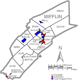
Under Pennsylvania law, there are four types of incorporated municipalities: cities, boroughs, townships, and, in at most two cases, towns. The following cities, boroughs and townships are located in Mifflin County:
Boroughs
- Burnham
- Juniata Terrace
- Kistler
- Lewistown (county seat)
- McVeytown
- Newton Hamilton
Townships
Census-designated places
Census-designated places are geographical areas designated by the U.S. Census Bureau for the purposes of compiling demographic data. They are not actual jurisdictions under Pennsylvania law. Other unincorporated communities, such as villages, may be listed here as well.
Population ranking
The population ranking of the following table is based on the 2010 census of Mifflin County.[13]
† county seat
| Rank | City/Town/etc. | Municipal type | Population (2010 Census)
|
|---|---|---|---|
| 1 | † Lewistown | Borough | 8,338 |
| 2 | Burnham | Borough | 2,054 |
| 3 | Belleville | CDP | 1,827 |
| 4 | Church Hill | CDP | 1,627 |
| 5 | Milroy | CDP | 1,498 |
| 6 | Highland Park | CDP | 1,380 |
| 7 | Yeagertown | CDP | 1,050 |
| 8 | Strodes Mills | CDP | 757 |
| 9 | Reedsville | CDP | 641 |
| 10 | Juniata Terrace | Borough | 542 |
| 11 | Allensville | CDP | 503 |
| 12 | Granville | CDP | 440 |
| 13 | Maitland | CDP | 357 |
| 14 | McVeytown | Borough | 342 |
| 15 | Kistler | Borough | 320 |
| 16 | Mattawana | CDP | 276 |
| 17 | Lumber City | CDP | 255 |
| 18 | Longfellow | CDP | 215 |
| 19 | Newton Hamilton | Borough | 205 |
| 20 | Cedar Crest | CDP | 195 |
| 21 | Atkinson Mills | CDP | 174 |
| 22 | Potlicker Flats | CDP | 172 |
| 23 | Barrville | CDP | 160 |
| 24 | Alfarata | CDP | 149 |
| 25 | Wagner | CDP | 128 |
| 26 | Siglerville | CDP | 106 |
See also
References
- 1 2 "State & County QuickFacts". United States Census Bureau. Archived from the original on July 14, 2011. Retrieved November 20, 2013.
- ↑ "Find a County". National Association of Counties. Retrieved 2011-06-07.
- ↑ "2010 Census Gazetteer Files". United States Census Bureau. August 22, 2012. Retrieved March 9, 2015.
- ↑ "Population and Housing Unit Estimates". Retrieved June 9, 2017.
- ↑ "U.S. Decennial Census". United States Census Bureau. Retrieved March 9, 2015.
- ↑ "Historical Census Browser". University of Virginia Library. Retrieved March 9, 2015.
- ↑ Forstall, Richard L., ed. (March 24, 1995). "Population of Counties by Decennial Census: 1900 to 1990". United States Census Bureau. Retrieved March 9, 2015.
- ↑ "Census 2000 PHC-T-4. Ranking Tables for Counties: 1990 and 2000" (PDF). United States Census Bureau. April 2, 2001. Retrieved March 9, 2015.
- ↑ "American FactFinder". United States Census Bureau. Retrieved 2008-01-31.
- ↑ The 12 Largest Amish Communities (2017). at Amish America
- ↑ "Office of Management and Budget". whitehouse.gov. Retrieved 3 April 2018.
- ↑ "Archived copy". Archived from the original on 2015-09-24. Retrieved 2017-12-07.
- 1 2 Promotions, Center for New Media and. "US Census Bureau 2010 Census". www.census.gov. Retrieved 3 April 2018.
- ↑ Leip, David. "Dave Leip's Atlas of U.S. Presidential Elections". uselectionatlas.org. Retrieved 3 April 2018.
- ↑ http://abc27.com/2016/08/22/county-commissioner-wont-apologize-for-controversial-facebook-post/
- ↑ "Lisa Nancollas resigns as Mifflin County commissioner | News, Sports, Jobs - The Sentinel". www.lewistownsentinel.com. Retrieved 2017-06-06.
- ↑ "Postal to serve as county commissioner | News, Sports, Jobs - The Sentinel". www.lewistownsentinel.com. Retrieved 2017-06-06.
- 1 2 Center, Legislativate Data Processing. "Find Your Legislator". The official website for the Pennsylvania General Assembly. Retrieved 2017-05-09.
- ↑ Snyder, Union, Mifflin Child Development Report. Feb 2010
Further reading
- Raymond Martin Bell, Mifflin County, Pennsylvania: Families and Records before 1800. Washington, PA: Raymond Martin Bell, 1987.
- Raymond Martin Bell, Mifflin County, Pennsylvania, in the Revolution, 1775-1783. Washington, PA: Raymond Martin Bell, 1993.
- Raymond Martin Bell, The Houses of Mifflin County, Pennsylvania. Washington, PA: Raymond Martin Bell, 1970.
- Forest K Fisher, Mifflin County. Charleston, SC: Arcadia Publishing, 2008.
- I. Daniel Rupp, History of Mifflin County, Pennsylvania. Laughlintown, PA: Southwest Pennsylvania Genealogical Services, n.d. [1983].
- John Martin Stroup, The Amish of the Kishacoquillas Valley, Mifflin County, Pennsylvania: When Did They Come, and Why? What of the Future? Lewistown, PA: Mifflin County Historical Society, 1965.
- John Martin Stroup and Raymond Martin Bell, The Genesis of Mifflin County Pennsylvania: Its Aborigines, Explorers, Early Settlement and Development, Indian Wars and The Revolution, and Formation as a County. Lewistown, PA: Mifflin County Historical Society, 1957.
- John Martin Stroup and Raymond Martin Bell, The People of Mifflin County, Pennsylvania, 1755-1798: Pioneer Settlers and Defenders of the Frontier During the Revolution. Lewistown, PA: Mifflin County Historical Society, 1973.
- John Martin Stroup and Raymond Martin Bell, The Pioneers of Mifflin County, Pennsylvania: Who's Who in the Early Records with an Account of the Growth of the County before 1790. Lewistown, PA: [Mifflin County Historical Society], 1942.
- The Cemeteries of Mifflin County, Pennsylvania. Lewistown, PA: Mifflin County Historical Society, 1977.
- Two Hundred Years: A Chronological List of Events in the History of Mifflin County, Pennsylvania. Lewistown, PA: Mifflin County Historical Society, 1957.
External links
- Pennsylvania Department of Transportation, Bureau of Planning and Research, Geographic Information Division, "2005 General Highway Map of Juniata and Mifflin Counties". Note: shows boroughs, townships, roads, villages, some streams. URL accessed on April 5, 2006.
- JuniataRiverValley.org Note: Visitor Bureau
Municipalities and communities of Mifflin County, Pennsylvania, United States | ||
|---|---|---|
| Boroughs | | |
| Townships | ||
| CDPs | ||
| Unincorporated community | ||