New Garden Township, Chester County, Pennsylvania
| New Garden Township | |
|---|---|
| Township | |
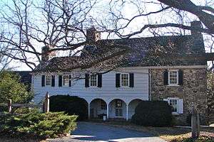 Merestone, a historic estate in the township | |
 Location in Chester County and the state of Pennsylvania. | |
.svg.png) Location of Pennsylvania in the United States | |
| Coordinates: 39°50′08″N 75°46′01″W / 39.83556°N 75.76694°WCoordinates: 39°50′08″N 75°46′01″W / 39.83556°N 75.76694°W | |
| Country | United States |
| State | Pennsylvania |
| County | Chester |
| Area[1] | |
| • Total | 16.29 sq mi (42.18 km2) |
| • Land | 16.11 sq mi (41.73 km2) |
| • Water | 0.17 sq mi (0.45 km2) |
| Elevation | 472 ft (144 m) |
| Population (2010) | |
| • Total | 11,984 |
| • Estimate (2016)[2] | 12,053 |
| • Density | 748.03/sq mi (288.81/km2) |
| Time zone | UTC-5 (EST) |
| • Summer (DST) | UTC-4 (EDT) |
| Area code(s) | 610 |
| FIPS code | 42-029-53608 |
| Website |
www |
New Garden Township is a township in Chester County, Pennsylvania, United States which was organized in 1714. The population was 11,984 at the 2010 census. New Garden is the center of the mushroom agribusiness in southeastern Pennsylvania with a higher concentration of composting, mushroom growing, packaging, and shipping businesses than in any other municipality in the area. It was named for the New Garden Friends' Meeting House, an eighteenth-century brick house of worship of the Religious Society of Friends, within its territorial limits.
History
Merestone was added to the National Register of Historic Places in 1995.[3]
Geography
According to the United States Census Bureau, the township has a total area of 16.2 square miles (42 km2), of which 16.1 square miles (42 km2) is land and 0.1 square miles (0.26 km2), or 0.31%, is water.
Demographics
At the 2010 census, the township was 66.8% non-Hispanic White, 3.0% Black or African American, 0.5% Native American, 3.0% Asian, and 2.2% were two or more races. 26.4% of the population were of Hispanic or Latino ancestry.[4]
As of the census[5] of 2000, there were 9,083 people, 2,700 households, and 2,200 families residing in the township. The population density was 562.9 people per square mile (217.3/km²). There were 2,831 housing units at an average density of 175.5/sq mi (67.7/km²). The racial makeup of the township was 84.91% White, 3.67% African American, 0.41% Native American, 1.30% Asian, 0.04% Pacific Islander, 8.07% from other races, and 1.61% from two or more races. Hispanic or Latino of any race were 22.73% of the population.
There were 2,700 households, out of which 46.9% had children under the age of 18 living with them, 70.6% were married couples living together, 6.4% had a female householder with no husband present, and 18.5% were non-families. 14.0% of all households were made up of individuals, and 4.5% had someone living alone who was 65 years of age or older. The average household size was 3.16 and the average family size was 3.45.
| Historical population | |||
|---|---|---|---|
| Census | Pop. | %± | |
| 1930 | 2,391 | — | |
| 1940 | 2,716 | 13.6% | |
| 1950 | 3,027 | 11.5% | |
| 1960 | 3,718 | 22.8% | |
| 1970 | 4,153 | 11.7% | |
| 1980 | 4,790 | 15.3% | |
| 1990 | 5,430 | 13.4% | |
| 2000 | 9,083 | 67.3% | |
| 2010 | 11,984 | 31.9% | |
| Est. 2016 | 12,053 | [2] | 0.6% |
| [6] | |||
In the township the population was spread out, with 30.7% under the age of 18, 8.2% from 18 to 24, 34.1% from 25 to 44, 19.7% from 45 to 64, and 7.2% who were 65 years of age or older. The median age was 34 years. For every 100 females there were 119.2 males. For every 100 females age 18 and over, there were 121.8 males.
The median income for a household in the township was $75,307, and the median income for a family was $89,812. Males had a median income of $54,524 versus $32,792 for females. The per capita income for the township was $30,364. About 0.8% of families and 5.7% of the population were below the poverty line, including none of those under age 18 and 11.4% of those age 65 or over.
References
- ↑ "2016 U.S. Gazetteer Files". United States Census Bureau. Retrieved Aug 13, 2017.
- 1 2 "Population and Housing Unit Estimates". Retrieved June 9, 2017.
- ↑ National Park Service (2010-07-09). "National Register Information System". National Register of Historic Places. National Park Service.
- ↑ https://www.usatoday.com/news/nation/census/profile/PA
- ↑ "American FactFinder". United States Census Bureau. Retrieved 2008-01-31.
- ↑ http://www.dvrpc.org/data/databull/rdb/db82/appedixa.xls