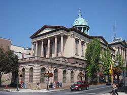
Lancaster County, Pennsylvania
| Lancaster County, Pennsylvania | ||
|---|---|---|
 | ||
| ||
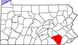 Location in the U.S. state of Pennsylvania | ||
 Pennsylvania's location in the U.S. | ||
| Founded | May 10, 1729 | |
| Named for | Lancaster, Lancashire | |
| Seat | Lancaster | |
| Largest city | Lancaster | |
| Area | ||
| • Total | 984 sq mi (2,549 km2) | |
| • Land | 944 sq mi (2,445 km2) | |
| • Water | 40 sq mi (104 km2), 4.1% | |
| Population (est.) | ||
| • (2017) | 542,903 | |
| • Density | 575/sq mi (222/km2) | |
| Congressional district | 11th | |
| Time zone | Eastern: UTC−5/−4 | |
| Website |
www | |

Lancaster County locally /ˈlæŋkəstər/, (Pennsylvania German: Lengeschder Kaundi) sometimes nicknamed the Garden Spot of America or Pennsylvania Dutch Country, is a county located in the south central part of the Commonwealth of Pennsylvania.[1] As of the 2010 census, the population was 519,445.[2] Its county seat is Lancaster.[3]
Lancaster County comprises the Lancaster, Pennsylvania, Metropolitan Statistical Area.
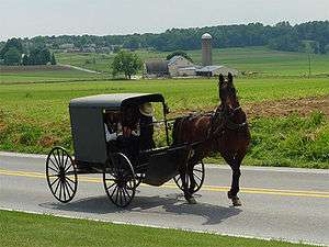
The County of Lancaster is a popular tourist destination, with its Amish community a major attraction. The "Dutch" of Pennsylvania Dutch is the English form of Düütsch, the Low German cognate of Standard German Deutsch and Pennsylvania Dutch Deitsch. (Historically, the terms "German" and "Dutch" were used interchangeably to describe all of the Germanic peoples living within the boundaries of the Holy Roman Empire.) The ancestors of the Amish began to immigrate to colonial Pennsylvania in the early 18th century to take advantage of the religious freedom offered by William Penn.[4] They were also attracted by the area's rich soil and mild climate.[5] Also attracted to promises of religious freedom, French Huguenots fleeing religious persecution settled this area in 1710.[6][7] There were also significant numbers of English, Welsh and Ulster Scots (also known as the Scotch-Irish in the colonies).
History
The area that became Lancaster County was part of William Penn's 1681 charter.[8] John Kennerly received the first recorded deed from Penn in 1691.[9] Although Matthias Kreider was said to have been in the area as early as 1691, there is no evidence that any Europeans settled in Lancaster County before 1710.[10]
Lancaster County was part of Chester County, Pennsylvania until 10 May 1729, when it was organized as colony's fourth county.[11] It was named after the city of Lancaster in the county of Lancashire in England, the native home of John Wright, an early settler.[12] As settlement increased, six other counties were subsequently formed from territory directly taken, in all or in part, from Lancaster County: Berks (1752), Cumberland (1750), Dauphin (1785), Lebanon (1813), Northumberland (1772), and York (1749).[11] Many other counties were in turn formed from these six.
Indigenous peoples
Indigenous peoples had occupied the areas along the waterways for thousands of years, and established varying cultures. Historic Native American tribes in the area at the time of European encounter included the Shawnee, Susquehannock, Gawanese, Lenape (or Delaware), and Nanticoke peoples, who were from different language families and had distinct cultures.[13]
Among the earliest recorded inhabitants of the Susquehanna River valley were the Iroquoian-speaking Susquehannock, whose name was derived from the Lenape term for "Oyster River People". (The Lenape spoke an Algonquian language.)[14] The English called them the Conestoga, after the name of their principal village, Gan'ochs'a'go'jat'ga ("Roof-place" or "town"), anglicized as "Conestoga."[15] Other places occupied by the Susquehannock were Ka'ot'sch'ie'ra ("Place-crawfish"), where present-day Chickisalunga developed, and Gasch'guch'sa ("Great-fall-in-river"), now called Conewago Falls, Lancaster County.[16]
Other Native tribes, as well as early European settlers, considered the Susquehannock a mighty nation, experts in war and trade. They were beaten only by the combined power of the Five Nation Iroquois Confederacy, after colonial Maryland withdrew its support. After 1675, the Susquehannock were totally absorbed by the Iroquois. A handful were settled at "New Conestoga," located along the south bank of the Conestoga River in Conestoga Township of the county. They helped staff an Iroquois consulate to the English in Maryland and Virginia (and later, Pennsylvania). By the 1720s, the colonists considered the Conestoga Indians as a "civilized" or "friendly tribe," having been converted in large part to Christianity, speaking English as a second language, making brooms and baskets for sale, and naming children after their favorite neighbors.[17]
The outbreak of Pontiac's War in the summer of 1763, coupled with the ineffective policies of the provincial government, aroused widespread settler suspicion and hatred against all Indians in the frontier counties, without distinguishing among hostile and friendly peoples. On 14 December 1763, the Paxton Boys, led by Matthew Smith and Capt. Lazarus Stewart, attacked Conestoga, killing the six Indians present, and burning all the houses. Officials sheltered the tribe's fourteen survivors in protective custody in the county jail, but the Paxton Boys returned on 27 December, broke into the jail, and massacred the remaining natives. The lack of effective government control and widespread sympathy in the frontier counties for the murderers meant they were never discovered or brought to justice.[18]
Maryland-Pennsylvania boundary dispute
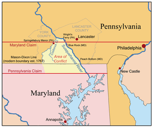
Pennsylvania had a longstanding dispute with Maryland about the southern border of the province and Lancaster County. Nine years of armed clashes accompanied the Maryland-Pennsylvania boundary dispute, which began soon after the 1730 establishment of Wright's Ferry across the Susquehanna River. Lord Baltimore believed that his grant[19] to Maryland extended to the 40th parallel.[20] This was about halfway between present-day Lancaster and the town of Willow Street, Pennsylvania. This line of demarcation would have resulted in Philadelphia's being included in Maryland.
New settlers began to cross the Susquehanna. In 1730, the Wright's Ferry services were licensed and officially begun. Starting in mid-1730, Thomas Cresap, acting as an agent of Lord Baltimore, began confiscating the newly settled farms near present-day Peach Bottom and Columbia, Pennsylvania (at the time this was not named, but it was first called "Wright's Ferry", as noted on map). Believing he controlled this land under his grant, Lord Baltimore wanted the income from the lands. He believed he had a defensible claim established on the west bank of the Susquehanna since 1721, and that his demesne and grant extended to forty degrees north. If he allowed Pennsylvanians to settle his lands without reacting, their squatting would constitute a counter claim.
Cresap established a second ferry in the upper Conejohela downriver from John Wright's, near Peach Bottom. He demanded that settlers either move out or pay Maryland for the right-bank lands. Settlers believed they already had rights to these under Pennsylvania grants. Cresap drove off settlers by vandalizing farms and killing livestock; he pushed out settlers from southern York and Lancaster counties. He gave the abandoned lands to his followers. If a follower was arrested by Lancaster authorities, the Marylanders would break him out of the lockup.
Lord Baltimore negotiated a compromise in 1733, but Cresap ignored it and continued his raids. A deputy was sent to arrest him in 1734, and Cresap killed him at the door. The Pennsylvania governor demanded that Maryland arrest Cresap for murder; the Maryland governor instead commissioned him as a captain in the militia. In 1736, Cresap was finally arrested; he was jailed until 1737 when the King intervened. In 1750, a court decided that, by failing to develop the land with settlers, Lord Baltimore had forfeited his rights to a twenty-mile (32 km) swath of land.[20] In 1767, a new Pennsylvania-Maryland border was officially established by the Mason-Dixon line.
Diversity of settlers
The names of the original Lancaster County townships reflect the diverse national origins of settlers in the new county:[21] two had Welsh names (Caernarvon and Lampeter), three had Native American names (Cocalico, Conestoga and Peshtank or Paxton), six were English (Warwick, Lancaster, Martic, Sadsbury, Salisbury and Hempfield); four were Irish (Donegal, Drumore, Derry, and Leacock), reflecting mostly Scots-Irish (or Ulster Scots) from Ulster, a province in the north of Ireland; Manheim was German, Lebanon came from the Bible, a basis of all the European cultures; and Earl was a translation of the German surname of Graf or Groff.[22]
19th-century statesmen
Lancaster County's native son James Buchanan, a Democrat, was elected as the 15th President of the United States in 1856,[23] the only Pennsylvania native to hold the presidency. His home Wheatland is now operated as a house museum in Lancaster.[24]
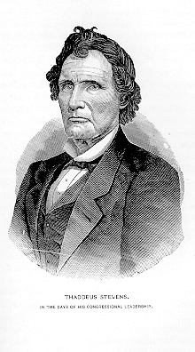
Thaddeus Stevens, the noted Radical Republican, represented Lancaster County in the United States House of Representatives from 1849–1853 and from 1859 until his death in 1868.[25] Stevens left a $50,000 bequest to establish an orphanage.[26] This property eventually was developed as the state-owned Thaddeus Stevens College of Technology. Stevens and Buchanan were both buried in Lancaster.[27]
Slavery and the Christiana incident
Pennsylvania abolished slavery in 1780, with gradual implementation.[28] The existing 6000 slaves in Pennsylvania remained slaves, and the registered children of those slaves were enslaved until their 28th birthday. The last slave child registered in Pennsylvania was Haley, born in 1811, who became a freedman no later than 1839.[29] Pennsylvania was a completely free state when the Fugitive Slave Law of 1850 was passed by Congress as part of the Compromise of 1850. It regarded slaves brought voluntarily to the state by their masters as free, and did not pay compensation if the slave chose to take freedom in the state.
Lying just north of the Mason-Dixon line, bordered by the Susquehanna River which had been a traditional route from the Chesapeake Bay watershed into the heart of what became Pennsylvania, Lancaster County was a significant destination of the Underground Railroad in the antebellum years. Many of the people of German descent opposed slavery and cooperated in aiding fugitive slaves. Local Lancaster County resident Charles Spotts found 17 stations.[30] They included hiding places with trap doors, hidden vaults, a cave, and one with a brick tunnel leading to Octoraro Creek, a tributary of the Susquehanna.
As a wealthy Maryland wheat farmer, Edward Gorsuch had manumitted several slaves in their 20s. He allowed his slaves to work for cash elsewhere during the slow season. Upon finding some of his wheat missing, he thought his slaves had sold it to a local farmer. His slaves Noah Buley, Nelson Ford, George Ford, and Joshua Hammond, fearing his bad temper, fled across the Mason–Dixon line to the farm of William Parker, a mulatto free man and abolitionist who lived in Christiana, Pennsylvania. Parker, 29, was a member of the Lancaster Black Self-Protection Society and known to use violence to defend himself and the fugitive slaves who sought refuge in the area.
Gorsuch obtained four warrants and organized four parties, which set out separately with federal marshals to recover his property—the four slaves. He was killed and others were wounded. While Gorsuch was legally entitled to recover his slaves under the Fugitive Slave Act, it is not clear who precipitated the violence. The incident was variously called the "Christiana Riot", "Christiana Resistance", the "Christiana Outrage", and the "Christiana Tragedy". The Pennsylvania Anti-Slavery Society helped provide defense for the suspects charged in the case.
The event frightened slaveholders, as black men not only fought back but prevailed. Some feared this would inspire enslaved blacks and encourage rebelliousness. The case was prosecuted in Philadelphia U.S. District Court under the Fugitive Slave Act, which required citizens to cooperate in the capture and return of fugitive slaves. The disturbance increased regional and racial tensions. In the North, it added to the push to abolish slavery.[31]
In September 1851, the grand jury returned a "true bill" (indictment) against 38 suspects, who were held in Philadelphia's Moyamensing Prison to await trial. U.S. District Judge John K. Kane ruled that the men could be tried for treason.
The only person actually tried was Castner Hanway, a European-American man. On 15 November 1851 he was tried for liberating slaves taken into custody by U.S. Marshal Kline, as well as for resisting arrest, conspiracy, and treason. Hanway's responsibility for the violent events was unclear. He was reported as one of the first on the scene where Gorsuch and others of his party were attacked, and he and his horse provided cover for Dickerson Gorsuch and Dr. Pearce, who were wounded. The jury deliberated 15 minutes before returning a Not Guilty. Among the five defense lawyers, recruited by the Pennsylvania Anti-Slavery Society, was U.S. Congressman Thaddeus Stevens, who had practiced law in Lancaster County since at least 1838.[32]
Religious history
The oldest surviving dwelling of European settlers in the county[33] is that of Mennonite Bishop Hans Herr, built in 1719. In 1989, Donald Kraybill counted 37 distinct religious bodies/organizations, with 289 congregations and 41,600 baptized members, among the plain sects who are descendants of the Anabaptist Mennonite immigrants to Lancaster County.[34] The Mennonite Central Committee in Akron supports relief in disasters[35] and provides manpower and material to local organizations in relief efforts.[36]
The town of Lititz was originally planned as a closed community, founded early in the 1740s by members of the Moravian Church. The town eventually grew and welcomed its neighbors. The Moravian Church established Linden Hall School for Girls in 1746; it is one of the earliest educational institutions in continuous operation in the United States.[37]
In addition to the Ephrata Cloister, the United Brethren in Christ and the Evangelical United Brethren (EUB) trace their beginnings to a 1767 meeting[38] at the Isaac Long barn, near the hamlet of Oregon, in West Lampeter Township.[39] The EUB, a German Methodist church, merged in 1968 with the traditionally English Methodist Episcopal Church to become the United Methodist Church.[40]
The first Jewish resident was Isaac Miranda , from the Sephardic Jewish community of London, who owned property before the town and county were organized in 1730. Ten years later several Jewish families had settled in the town; on 3 February 1747, a deed to Isaac Nunus Ricus (Henriques) and Joseph Simon was recorded, conveying 0.5 acres (2,000 m2) of land "in trust for the society of Jews settled in and about Lancaster," to be used as a place of burial. This cemetery is still used by Congregation Shaarai Shomayim;[41] it is considered the nation's fourth-oldest Jewish cemetery.
As of 2010, Lancaster County is home to three synagogues: the Orthodox Degel Israel; the Conservative Beth El; and the Reform Shaarai Shomayim. In 2003 Rabbi Elazar Green & Shira Green founded the Chabad Jewish Enrichment Center, a branch of the Chabad Lubavitch movement, that focuses on serving the Jewish students of Franklin and Marshall College, as well serving the general community with specific religious services. The Lancaster Mikvah Association runs a mikveh on Degel Israel's property. Central PA Kosher Stand is operated at Dutch Wonderland, a seasonal amusement park.
This area was also settled by French Huguenots, who had fled to England and then the colonies in the late 1600s and early 1700s to escape Catholic persecution in France. Isaac LeFèvre and a group of other Huguenots settled in the Pequea Creek area.
Inventions
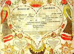
- Fraktur, the artistic and elaborate 18th- century and 19th-century hand-illuminated folk art inspired by German blackface type, originated at Johann Conrad Beissel's cloister of German Seventh Day Baptists in Ephrata.[42]
- The first battery-powered watch, the Hamilton Electric 500, was released in 1957 by the Hamilton Watch Company.[43]
- The Pennsylvania Long Rifle,[44] otherwise known as the "Kentucky" (Long) Rifle.
- The Conestoga wagon,[45] which started the US practice of opposing vehicles passing each other to the right.
- The Stogie cigar[46] "Stogie" is shortened from "Conestoga".
- The Amish quilt, a highly utilitarian art form, dates from 1849 in Lancaster County.[47]
Geography
According to the U.S. Census Bureau, the county has a total area of 984 square miles (2,550 km2), of which 944 square miles (2,440 km2) is land and 40 square miles (100 km2) (4.1%) is water.[48]
Watersheds
Almost all of Lancaster County is in the Chesapeake Bay drainage basin, via the Susquehanna River watershed (the exception is a small unnamed tributary of the West Branch of Brandywine Creek that rises in eastern Salisbury Township and is part of the Delaware River watershed).[49] The major streams in the county (with percent area drained) are: Conestoga River and Little Conestoga Creek (31.42%); Pequea Creek (15.02%); Chiques Creek (or Chickies Creek, 12.07%); Cocalico Creek (11.25%); Octoraro Creek (10.74%); and Conowingo Creek (3.73%).[50]
Protected areas
Lancaster County is home to Susquehannock State Park, located on 224 acres (91 ha) overlooking the Susquehanna River in Drumore Township.[51] One of the three tracts comprising William Penn State Forest, the 10-acre (4.0 ha) Cornwall fire tower site, is located in northern Penn Township near the Lebanon County border. The site, with its 1923 fire tower, was acquired by the state in January 1935.[52]
There are six Pennsylvania State Game Lands for hunting, trapping, and fishing located in Lancaster County. They are numbers (with location and area): 46 (near Hopeland, 5,035 acres (2,038 ha)), 52 (near Morgantown, 1,447 acres (586 ha)), 136 (near Kirkwood, 91 acres (37 ha)), 156 (near Poplar Grove, 4,537 acres (1,836 ha)), 220 (near Reinholds, 96 acres (39 ha)), and 288 (near Martic Forge, 89 acres (36 ha)).[53]
The county's southern portion has some protected serpentine barrens, a rare ecosystem where toxic metals in the soil inhibit plant growth, resulting in the formation of natural grassland and savanna. These barrens include the New Texas Serpentine Barrens, privately owned land managed by The Nature Conservancy,[54] and Rock Springs Nature Preserve, a publicly accessible preserve with hiking trails owned and managed by the Lancaster County Conservancy.[55]
Lancaster County leads the nation in farmland preservation. Organizations such as the Lancaster Farmland Trust, the Lancaster County Agricultural Preservation Board, and multiple municipalities work in partnership with landowners to preserve their farms and way of life for future generations by placing a conservation easement on their property. A conservation easement restricts real estate development, commercial and industrial uses, and certain other activities on the land that are mutually agreed upon by the grantees and the property owner. After ceding their development rights, landowners continue to manage and own their properties and may receive significant tax breaks. The conservation easement ensures that the land will remain available for agricultural use forever. Lancaster Farmland Trust is a private, non-profit organization that works closely with the vast Amish and Plain-Sect communities of Lancaster County to ensure their farms will retain their agricultural value. Together with the Lancaster County Agricultural Preserve Board, the County has preserved more than 100,000 acres (40,000 ha) of preserved farmland in the county—a first in the nation.[56]
Seismicity
Lancaster County lies on the general track of the Appalachian Mountains. As a result, residual seismic activity from ancient faulting occasionally produces minor earthquakes of magnitude 3 to 4. On 27 December 2008, a 3.3 magnitude earthquake was widely felt in the Susquehanna Valley but caused no damage to structures.[57]
Adjacent counties
- Lebanon County (North)
- Berks County (Northeast)
- Dauphin County (Northwest)
- Cecil County, Maryland (South)
- Harford County, Maryland (Southwest)
- Chester County (East)
- York County (West)
Flora and fauna
The bog turtle was first discovered and identified in Lancaster County by botanist Gotthilf Heinrich Ernst Muhlenberg, who discovered the turtle species while surveying the area's flora. The species was named Muhlenberg's tortoise in 1801, but renamed bog turtle, its present common name, in 1956.[58]
Demographics
| Historical population | |||
|---|---|---|---|
| Census | Pop. | %± | |
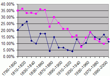
| 1790 | 36,081 | — | |
| 1800 | 43,403 | 20.3% | |
| 1810 | 53,927 | 24.2% | |
| 1820 | 68,336 | 26.7% | |
| 1830 | 76,631 | 12.1% | |
| 1840 | 84,203 | 9.9% | |
| 1850 | 98,944 | 17.5% | |
| 1860 | 116,314 | 17.6% | |
| 1870 | 121,340 | 4.3% | |
| 1880 | 139,447 | 14.9% | |
| 1890 | 149,095 | 6.9% | |
| 1900 | 159,241 | 6.8% | |
| 1910 | 167,029 | 4.9% | |
| 1920 | 173,797 | 4.1% | |
| 1930 | 196,882 | 13.3% | |
| 1940 | 212,504 | 7.9% | |
| 1950 | 234,717 | 10.5% | |
| 1960 | 278,359 | 18.6% | |
| 1970 | 319,693 | 14.8% | |
| 1980 | 362,346 | 13.3% | |
| 1990 | 422,822 | 16.7% | |
| 2000 | 470,658 | 11.3% | |
| 2010 | 519,445 | 10.4% | |
| Est. 2017 | 542,903 | [59] | 4.5% |
| U.S. Decennial Census[60] 1790-1960[61] 1900-1990[62] 1990-2000[63] 2010-2017[2] | |||
| Lancaster County Demographics[64] | |||
|---|---|---|---|
| 2013 | County | State | U.S. |
| White | 91.0% | 83.2% | 77.7% |
| African American | 4.7% | 11.5% | 13.2% |
| Native American | 0.4% | 0.3% | 1.2% |
| Asian | 2.1% | 3.1% | 5.3% |
| Pacific Islander | 0.1% | 0.1% | 0.2% |
| Two or more races | 1.8% | 1.8% | 2.4% |
| Hispanic/Latino of any race | 9.5% | 6.3% | 17.1% |
| White alone, not Hispanic or Latino | 83.6% | 78.4% | 62.6% |
As of the census[65] of 2010, there were 519,445 people. The population density was 561 people per square mile (217/km²). There were 193,602 households. Of that number 135,401 (69.9%) were families. Of those families, 120,112 (88.7%) had children under the age of 18. There were 202,952 housing units at an average density of 215 per square mile (83/km²). The average household size was 2.62 and the average family size was 3.13.
In the county, the population was spread out with 24.8% under the age of 18 and 15.0% who were 65 years of age or older. The median age was 38.2 years. For every 100 females, there were 95.10 males. For every 100 females age 18 and over, there were 91.60 males.
5.58% of the population and 8.37% of the children aged 5–17 reported speaking Pennsylvania German, German, or Dutch at home, while a further 4.97% of the population spoke Spanish.[66] 39.8% were of German, 11.8% United States or American, 7.2% Irish and 5.7% English ancestry.
Plain Anabaptist (Amish) groups
Lancaster County Anabaptist community founded in c. 1760, has the world's largest Amish settlement, with 37,000 people in 220 church districts in 2017, or about 7% of the county's population.[67] The Lancaster Amish affiliation is relatively liberal concerning the use of technologies compared to other Amish affiliation.
Lancaster also hosts other Plain Anabaptist groups. As of 2000, there are about 3,000 Old Order Mennonites of the Groffdale Conference who drive black top buggies instead of the grey top buggies of the Amish in Lancaster county. Other buggy-using Old Order Mennonites in Lancaster County are subgroups of the Stauffer Mennonites with 283 baptized members and the Reidenbach Mennonites with 232. There are about 4,000 members of the car-driving Weaverland Old Order Mennonite Conference. A congregation of 83 members of the Old Order River Brethren lives there as well as 84 members of the Reformed Mennonite Church who have retained the most conservative form of Plain dress of all Plain groups. There are 74 members of the Old German Baptist Brethren in Lancaster County.[68]
Religion
- Protestant: 38% (of whom Evangelical Protestant 23.7%, Mainline Protestant 13.8%, Black Protestant 0.4%)
- Roman Catholic: 9.9%
- Orthodox Christian: 0.3%
- Other: 1.1%
- Unaffiliated: 50.9%[69]
Dialect
Some County residents speak with a Pennsylvania Dutch-influenced dialect.[70] This is most common in the Lancaster, Lebanon, York, and Harrisburg areas, and incorporates influences from the Pennsylvania Dutch in dialect and in nomenclature.
Metropolitan Statistical Area
The United States Office of Management and Budget has designated Lancaster County as the Lancaster, PA Metropolitan Statistical Area.[71] The United States Census Bureau ranked the Lancaster, PA Metropolitan Statistical Area as the 102nd most populous metropolitan statistical area and the 100th most populous primary statistical area of the United States as of July 2012.[72][73] The Metro area is the State's 8th most populous; as of the 2010 US Census the population was 519,445.
Government and politics
Political party affiliation
| Year | Republican | Democratic | Third Parties |
|---|---|---|---|
| 2016 | 56.3% 137,914 | 37.2% 91,093 | 6.5% 15,825 |
| 2012 | 58.5% 130,669 | 39.6% 88,481 | 1.9% 4,201 |
| 2008 | 55.2% 126,568 | 43.4% 99,586 | 1.4% 3,095 |
| 2004 | 65.8% 145,591 | 33.6% 74,328 | 0.7% 1,453 |
| 2000 | 66.1% 115,900 | 31.3% 54,968 | 2.6% 4,499 |
| 1996 | 59.8% 92,875 | 31.6% 49,120 | 8.6% 13,291 |
| 1992 | 55.2% 88,447 | 27.6% 44,255 | 17.2% 27,478 |
| 1988 | 70.8% 96,979 | 28.5% 38,982 | 0.8% 1,068 |
| 1984 | 75.6% 99,090 | 23.9% 31,308 | 0.5% 618 |
| 1980 | 67.3% 79,963 | 25.3% 30,026 | 7.5% 8,908 |
| 1976 | 65.7% 72,106 | 32.4% 35,533 | 1.9% 2,037 |
| 1972 | 75.6% 81,036 | 22.6% 24,223 | 1.8% 1,879 |
| 1968 | 64.6% 69,953 | 27.6% 29,870 | 7.8% 8,484 |
| 1964 | 49.5% 52,243 | 50.3% 53,041 | 0.2% 224 |
| 1960 | 70.1% 78,390 | 29.7% 33,233 | 0.2% 266 |
| 1956 | 72.1% 69,026 | 27.7% 26,538 | 0.3% 237 |
| 1952 | 69.2% 64,193 | 30.4% 28,146 | 0.4% 382 |
| 1948 | 67.6% 46,306 | 31.1% 21,308 | 1.3% 885 |
| 1944 | 61.8% 44,888 | 37.6% 27,353 | 0.6% 432 |
| 1940 | 58.1% 44,939 | 41.6% 32,210 | 0.4% 269 |
| 1936 | 51.4% 42,272 | 46.7% 38,454 | 1.9% 1,547 |
| 1932 | 56.5% 34,502 | 40.0% 24,406 | 3.5% 2,111 |
| 1928 | 81.4% 55,530 | 17.8% 12,146 | 0.8% 516 |
| 1924 | 73.7% 42,787 | 20.8% 12,091 | 5.4% 3,156 |
| 1920 | 72.9% 29,549 | 23.5% 9,521 | 3.6% 1,472 |
| 1916 | 63.4% 20,292 | 31.3% 10,016 | 5.3% 1,688 |
| 1912 | 37.0% 12,668 | 25.0% 8,574 | 38.0% 13,040[75] |
| 1908 | 71.4% 23,523 | 24.6% 8,109 | 3.9% 1,299 |
| 1904 | 76.5% 26,083 | 20.8% 7,092 | 2.7% 902 |
| 1900 | 71.8% 23,230 | 26.1% 8,437 | 2.2% 701 |
| 1896 | 72.7% 24,337 | 24.3% 8,145 | 3.0% 1,008 |
| 1892 | 64.5% 20,126 | 33.1% 10,326 | 2.5% 770 |
| 1888 | 66.6% 21,976 | 31.8% 10,495 | 1.7% 545 |
For decades, Lancaster County has been a Republican stronghold. The GOP controls the vast majority of state, county and municipal elected offices in Lancaster County.[76] Specifically, the row offices and all but one county commission seat are held by Republicans, and the GOP holds all but one state legislative seat covering the county. Republicans also hold a plurality of registered voters in the county.
In September 2008, the Democratic Party reached the benchmark of 100,000 registered voters for the first time in the county's history.[76][77] The party had just 82,171 registered Democrats in 2004.[76] As of 2008, the ratio of Republicans to Democrats in Lancaster County now stands at 1.8 Republicans to 1 Democrat, down from a 3-1 advantage for the Republicans in the late 1990s.[76] Even with these gains, the only real pockets of Democratic influence are in the city of Lancaster.
As a measure of the county's strong Republican bent, it has only gone Democratic once since James Buchanan, a resident of Lancaster city, won it in 1856.[78] In 1964, Lyndon Johnson carried it as part of his 44-state landslide, but only did so by 798 votes. The Democrats would not come close to carrying the county again until 2008, when Barack Obama tallied 43 percent of the vote. However, the Democrats had been making gains in the county before then; in 2004, John Kerry became the first Democrat in 28 years to win more than one third of the vote.
United States Senate
| Senator | Party |
|---|---|
| Bob Casey | Democratic |
| Pat Toomey | Republican |
United States House of Representatives
| District | Representative | Party |
|---|---|---|
| 7 | Pat Meehan | Republican |
| 16 | Lloyd Smucker | Republican |
Pennsylvania State Senate[79]
| District | Representative | Party |
|---|---|---|
| 13 | Scott Martin | Republican |
| 36 | Ryan Aument | Republican |
Pennsylvania House of Representatives[80]
Commissioners
| Office | Holder | Party |
|---|---|---|
| County Commissioner | Josh Parsons | Republican |
| County Commissioner | Dennis Stuckey | Republican |
| County Commissioner | Craig Lehman | Democratic |
Source:[81]
Row Officers
| Office | Holder | Party |
|---|---|---|
| Clerk of Courts | Jacquelyn Pfursich | Republican |
| Controller | Brian Hurter | Republican |
| Coroner | Dr. Stephen Diamantoni, M.D. | Republican |
| District Attorney | Craig Stedman, Esq. | Republican |
| Prothonotary | Katherine Wood-Jacobs | Republican |
| Recorder of Deeds | Bonnie Bowman | Republican |
| Register of Wills | Ann Cooper | Republican |
| Sheriff | Mark Reese | Republican |
| Treasurer | Amber Green | Republican |
Economy
In 2004, the county had a per capita personal income (PCPI) of $30,790, 93% of the national average. This reflects a growth of 4.5% from the prior year, versus a 5.0% growth for the nation as a whole.[91] Despite the lower income, the county poverty rate in 2003 was 8.3% compared to a national rate of 12.5%. In 2004, federal spending in Lancaster County was $4,199 per resident, versus a national average of $7,232.[64]
In 2005, Lancaster County was 10th of all counties in Pennsylvania with 17.7% of its workforce employed in manufacturing; the state averages 13.7%, and the leader, Crawford County, has only 25.1%.[92]
Lancaster County lags in information workers, despite being the corporate headquarters of MapQuest.[93] It ranks 31st in the state with 1.3% of the workforce; the state as a whole employs 2.1% in information technology.[94]
The county ranks 11th in the state in managerial and financial workers, despite having 12.5% of the workforce in those occupations (versus the state average of 12.8%). The state leaders are Chester County with 20.5% and Montgomery County with 18.5%.[95]
With 17.3% working in the professions, Lancaster County is 31st in Pennsylvania, compared to a state average of 21.5%. Centre County leads with 31.8%, undoubtedly due to Penn State's giant footprint in an otherwise rural county, but the upscale Philadelphia suburbs of Montgomery County give them 27.2%.[96]
Lancaster County ranks even lower, 34th, in service workers, with 13.3% of the workforce, compared to a state average of 15.8%. Philadelphia County, leads with 20.5%.[97]
Lancaster County has an unemployment rate of 7.8% as of August 2010. This is a rise from a rate of 7.6% the previous year.[98]

There are 11,000 companies in Lancaster County.[99] The county's largest manufacturing and distributing employers at the end of 2003 were Acme Markets, Alumax Mill Products, Anvil International, Armstrong World Industries, Bollman Hat, CNH Global, Conestoga Wood Specialties, Dart Container, High Industries, Lancaster Laboratories, Pepperidge Farm, R R Donnelley & Sons, The Hershey Company, Tyco Electronics, Tyson Foods, Warner-Lambert, and Yellow Transportation.[100]
Auntie Anne's, Clipper Magazine, Lancaster Farming, MapQuest, Turkey Hill Dairy, Clair Global, and Wilbur Chocolate Company are Lancaster County-based organizations with an economic footprint of regional or national significance.
Herley Industries is a local producer of microwave and millimeter wave products for the defense and aerospace industries.
Agriculture
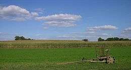
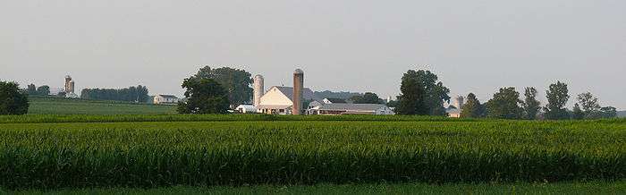
With some of the most fertile non-irrigated soil in the U.S., Lancaster County has a strong farming industry.[101][102] Lancaster County's 5293 farms, generating $800 million in food, feed and fiber, are responsible for nearly a fifth of the state's agricultural output.[103] Chester County, with its high-value mushroom farms, is second, with $375 million.[104]
Livestock-raising is responsible for $710 million of that $800 million, with dairy accounting for $266 million, poultry and eggs accounting for $258 million. Cattle and swine each accounts for about $90 million.[103]
Agriculture is likely to remain an important part of Lancaster County: almost exactly half of Lancaster County's land – 320,000 acres (130,000 ha) – is zoned for agriculture, and of those, 276,000 acres (112,000 ha) are "effective agricultural zoning", requiring at least 20 acres (8.1 ha) per residence.[105]
Tourism
Tourism is a significant industry in Lancaster County, employing approximately 20,000. In the 1860s, articles in the Atlantic Monthly and Lippincott's Magazine published right after the Civil War, introduced Lancaster County to many readers. However, tourism in Lancaster was nearly non-existent prior to 1955. A New York Times travel article in 1952 brought 25,000 visitors, but the 1955 Broadway musical Plain and Fancy helped to fan the flames of Amish tourism in the mid 1950s. Shortly thereafter, Adolph Neuber (then-owner of the Willows Restaurant) opened the first tourist attraction in Lancaster County showcasing the Amish culture. Lancaster County tourism tapered off, after the 1974 gas rationing and the Three Mile Island incident led to five years of stagnation.[106]

Local tourism officials viewed it as deus ex machina when Hollywood stepped in to rescue their industry. Harrison Ford, in the 1985 movie Witness, portrayed a Philadelphia detective who journeys to the Amish community in order to protect an Amish boy who has witnessed a murder in Philadelphia. The detective is attracted to the boy's widowed mother; the movie is less a thriller than a romance about the difficulties faced by an outsider in love with a widow from The Community.[107] The film was nominated for eight Oscars, and won two.[108] However, the real winner was Lancaster County tourism.
Once again, especially after the 9/11 attacks, tourism in Lancaster County has shifted. Instead of families arriving for a three- to four-day stay for a general visit, now tourists arrive for a specific event, whether it be the rhubarb festival, the "maize maze", to see Thomas the Tank Engine, for Sertoma's annual "World's Largest Chicken Barbecue" or for the latest show at Sight & Sound Theatres.[106] The tourism industry is discouraged by this change, but not despondent:
In four years of working here on the Strasburg Rail Road, I've only had one complaint, she said that the ride is too short. People love Lancaster County. They'll keep coming back.
— Betty McCormack[106]
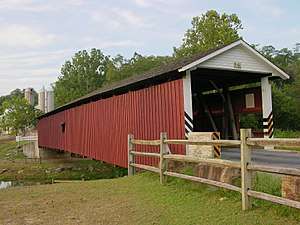
The county promotes tourist visits to the county's numerous historic and picturesque covered bridges by publishing driving tours of the bridges.[109] With over 200 bridges still in existence, Pennsylvania has more covered bridges than anywhere else in the world, and at 29 covered bridges, Lancaster County has the largest share.[110]
The Lancaster County Convention Center Authority constructed the $170 million[111] Lancaster County Convention Center in downtown Lancaster on the site of the former Watt & Shand building.[112]
Dutch Country cuisine has become popular with tourists, with several well-known restaurants, all-you-can-eat buffets, and smorgasbords becoming destinations in their own right, including Good 'N Plenty Restaurant, Plain & Fancy Restaurant, Bird-in-Hand Family Restaurant and Smorgasbord, Miller's, and Shady Maple Smorgasbord.
Other tourist attractions include the American Music Theatre, Dutch Wonderland, Ephrata Cloister, Ephrata Fair, Hans Herr House, Landis Valley Museum, Pennsylvania Dutch Country, Pennsylvania Renaissance Faire (one of the largest Renaissance fairs in the world[113]), Railroad Museum of Pennsylvania, Rock Ford plantation, Robert Fulton Birthplace, Sight & Sound Theatres, Strasburg Railroad, Wilbur Chocolate, Wheatland (James Buchanan House) and Sturgis Pretzel House. There are many tours of this historic area including the Downtown Lancaster Walking Tour.[114]
Education
Lancaster County's colleges include Eastern Mennonite University, Elizabethtown College, Franklin & Marshall College, Harrisburg Area Community College, Lancaster Bible College, Lancaster Theological Seminary, Millersville University of Pennsylvania, Pennsylvania College of Art and Design, Thaddeus Stevens College of Technology, and PA College of Health Sciences.

There are 16 public school districts in the county:
There is also one charter school, the La Academia Charter School.
Lancaster Country Day School, an independent day school, is located on the west end of Lancaster City.
Linden Hall, an independent boarding and day school for girls, is located in Lititz.
Lancaster County has a federated library system with 14 member libraries, three branches and a bookmobile. The Library System of Lancaster County was established in April 1987 to provide countywide services and cooperative programs for its member libraries. The Board of Lancaster County Commissioners appoints the Library System of Lancaster County's seven-member board of directors. The System is an agent of the Commonwealth.
Sports
Before the Barnstormers, Lancaster was the home of the Lancaster Red Roses, which played from 1906 to about 1930, and from 1932 to 1961.[115] In 2005 the Lancaster Barnstormers joined the Atlantic League of Professional Baseball. The Barnstormers are named after the "barnstorming" players who played exhibition games in the county. Their official colors are red, navy blue, and khaki, the same as those of the Red Roses. This franchise won their first league championship in their second season, in 2006. They won their second league championship in 2014. They have revived the old baseball rivalry between Lancaster and nearby York, called the War of the Roses, when the York Revolution started their inaugural season in 2007.[116]
The Women's Premier Soccer League expanded to Lancaster for the 2008 season, with the Lancaster Inferno. The WPSL is a FIFA-recognized women's league. The Inferno is owned by the Pennsylvania Classics organization and play their home games at the Hempfield High School stadium in Landisville. The Inferno's colors are orange, black, and white.
Amateur teams
In 2004, the amateur Lancaster Lightning football team of the North American Football League played at Pequea Valley High School's football stadium in Kinzers.[117]
Lancaster is home to the Dutchland Derby Rollers (DDR), a member of the Women's Flat Track Derby Association (WFTDA.) Founded in 2006, The Dutchland Rollers have two travel teams, the All-Stars and the Blitz. Both rosters play teams from neighboring leagues, though it is the Dutchland All-Stars that compete for national ranking. Their home rink is Overlook Activities Center, and their colors are orange and black.
Former teams
From 1946 to 1980, a professional basketball team, as the Lancaster Red Roses, (as well as the Lancaster Rockets and the Lancaster Lightning) played in the Continental Basketball Association.[118]
Transportation
Lying on the natural route from Philadelphia to the western part of Pennsylvania, Lancaster County has given rise to many improvements in transportation, such as the Philadelphia and Lancaster Turnpike, later part of the Lincoln Highway, in 1794,[119] a canal in 1820, and the Philadelphia and Columbia Railroad in 1834.[120]
Major Highways
Current railroads

As of 2006, passenger service in Lancaster County is provided by Amtrak, whose Keystone Corridor passes through the county, with stops at Lancaster, Mount Joy and Elizabethtown. A station is planned at Paradise to provide connecting service with the Strasburg Railroad, which runs passenger excursions from nearby Leaman Place to Strasburg.
The principal freight operator in the county is Norfolk Southern Railway (NS). The NS main line follows the Susquehanna River (with trackage rights for Canadian Pacific Railway (CPR)), and leaves the county by crossing the river on Shocks Mills Bridge near Marietta. NS also has trackage rights over the Keystone Corridor, to which it is connected by the Royalton Branch, which runs north along the river from the main line at Marietta, and the Columbia Branch, which runs from the Corridor at Dillerville to the main line at Columbia. Two other NS branches originate on the Corridor: the Lititz Secondary, which runs from Dillerville to Manheim and ends at Lititz, and the New Holland Industrial, which leaves the Corridor around the east end of Lancaster to run east to New Holland and ends at East Earl.
Several shortlines also operate in the county. With the exception of the Strasburg Railroad, all are freight railroads. The East Penn Railroad (ESPN) operates on a spur off the NS branch to Manheim, and on a longer line in the northeast corner of Lancaster County into Berks County. Landisville Terminal and Transfer Company (LNTV) operates on a spur off the Amtrak line at Landisville. The Tyburn Railroad operates some trackage around Dillerville. Most recently, the Columbia and Reading Railway (CORY) began operating on 2.5 miles (4.0 km) of track in Columbia in January 2010.[121]
Airport
There are two public airports in Lancaster County. Lancaster Airport has scheduled passenger service,and Smoketown Airport serves general aviation users.
Communities
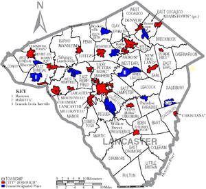
The following cities, boroughs, and townships are located in Lancaster County:
City
Boroughs
Christiana, Pennsylvania is the least populated borough in Lancaster County, as of 2010.[122] Ephrata is the most populous.
Townships
- Bart
- Brecknock
- Caernarvon
- Clay
- Colerain
- Conestoga
- Conoy
- Drumore
- Earl
- East Cocalico
- East Donegal
- East Drumore
- East Earl
- East Hempfield
- East Lampeter
- Eden
- Elizabeth
- Ephrata
- Fulton
- Lancaster
- Leacock
- Little Britain
- Manheim
- Manor
- Martic
- Mount Joy
- Paradise
- Penn
- Pequea
- Providence
- Rapho
- Sadsbury
- Salisbury
- Strasburg
- Upper Leacock
- Warwick
- West Cocalico
- West Donegal
- West Earl
- West Hempfield
- West Lampeter
Census-designated places
Census-designated places are geographical areas designated by the United States Census Bureau for the purposes of compiling demographic data. They are not actual jurisdictions under Pennsylvania law.
- Bainbridge
- Bareville
- Bird-in-Hand
- Blue Ball
- Bowmansville
- Brickerville
- Brownstown
- Churchtown
- Clay
- Conestoga
- East Earl
- Falmouth
- Farmersville
- Fivepointville
- Gap
- Georgetown
- Goodville
- Gordonville
- Hopeland
- Intercourse
- Kirkwood
- Lampeter
- Landisville
- Leola
- Little Britain
- Maytown
- Morgantown (mostly in Berks County)
- Paradise
- Penryn
- Reamstown
- Refton
- Reinholds
- Rheems
- Ronks
- Rothsville
- Salunga
- Schoeneck
- Smoketown
- Soudersburg
- Stevens
- Swartzville
- Wakefield
- Washington Boro
- Willow Street
- Witmer
Unincorporated communities
Many communities are neither incorporated nor treated as census-designated places.
- Aberdeen
- Arcadia
- Bamford
- Bausman
- Belair Park
- Bellaire
- Benton
- Billmeyer
- Black Baron
- Blainsport
- Bloomingdale
- Blossom Hill
- Bridgeport
- Bruckarts
- Brunnerville
- Buck
- Buena Vista
- Buyerstown
- Cocalico
- Conewago
- Creswell
- Dillerville
- Elm
- Fertility
- Hempfield
- Hinkletown
- Holtwood
- Kinzers
- Kissel Hill
- Leaman Place
- Lyndon
- Martindale
- Mastersonville
- Mechanics Grove
- Narvon
- New Danville
- Neffsville
- Nickel Mines
- Pequea
- Safe Harbor
- Silver Spring
- Talmage
- White Horse
- Vintage
Population ranking
The population ranking of the following table is based on the 2010 census of Lancaster County.[123]
† county seat:
| Rank | City/Town/etc. | Municipal type | Population (2010 Census)
|
|---|---|---|---|
| 1 | † Lancaster | City | 59,322 |
| 2 | Ephrata | Borough | 13,394 |
| 3 | Elizabethtown | Borough | 11,545 |
| 4 | Columbia | Borough | 10,400 |
| 5 | Lititz | Borough | 9,369 |
| 6 | Millersville | Borough | 8,168 |
| 7 | Willow Street | CDP | 7,578 |
| 8 | Mount Joy | Borough | 7,410 |
| 9 | Leola | CDP | 7,214 |
| 10 | New Holland | Borough | 5,378 |
| 11 | Manheim | Borough | 4,858 |
| 12 | East Petersburg | Borough | 4,506 |
| 13 | Akron | Borough | 3,876 |
| 14 | Denver | Borough | 3,861 |
| 15 | Maytown | CDP | 3,824 |
| 16 | Reamstown | CDP | 3,361 |
| 17 | Rothsville | CDP | 3,044 |
| 18 | Brownstown | CDP | 2,816 |
| 19 | Strasburg | Borough | 2,809 |
| 20 | Mountville | Borough | 2,802 |
| 21 | Salunga | CDP | 2,695 |
| 22 | Marietta | Borough | 2,588 |
| 23 | Quarryville | Borough | 2,576 |
| 24 | Swartzville | CDP | 2,283 |
| 25 | Bowmansville | CDP | 2,077 |
| 26 | Gap | CDP | 1,931 |
| 27 | Landisville | CDP | 1,893 |
| 28 | Reinholds | CDP | 1,803 |
| 29 | Adamstown (partially in Berks County) | Borough | 1,789 |
| 30 | Lampeter | CDP | 1,669 |
| 31 | Rheems | CDP | 1,598 |
| 32 | Clay | CDP | 1,559 |
| 33 | Bainbridge | CDP | 1,355 |
| 34 | Brickerville | CDP | 1,309 |
| 35 | Terre Hill | Borough | 1,295 |
| 36 | Intercourse | CDP | 1,274 |
| 37 | Conestoga | CDP | 1,258 |
| 38 | Christiana | Borough | 1,168 |
| 39 | Fivepointville | CDP | 1,156 |
| 40 | East Earl | CDP | 1,144 |
| 41 | Paradise | CDP | 1,129 |
| 42 | Schoeneck | CDP | 1,056 |
| 43 | Blue Ball | CDP | 1,031 |
| 44 | Penryn | CDP | 1,024 |
| 45 | Georgetown | CDP | 1,022 |
| 46 | Farmersville | CDP | 991 |
| 47 | Morgantown (mostly in Berks County) | CDP | 826 |
| 48 | Hopeland | CDP | 738 |
| 49 | Washington Boro | CDP | 729 |
| 50 | Stevens | CDP | 612 |
| 51 | Wakefield | CDP | 609 |
| 52 | Soudersburg | CDP | 540 |
| 53 | Gordonville | CDP | 508 |
| 54 | Witmer | CDP | 492 |
| 55 | Goodville | CDP | 482 |
| 56 | Churchtown | CDP | 470 |
| 57 | Falmouth | CDP | 420 |
| 58 | Bird-in-Hand | CDP | 402 |
| 59 | Kirkwood | CDP | 396 |
| 60 | Little Britain | CDP | 372 |
| 61 | Ronks | CDP | 362 |
| 62 | Smoketown | CDP | 357 |
| 63 | Refton | CDP | 298 |
See also
References
- ↑ Walbert, David J. (2002). Garden Spot: Lancaster County, Pennsylvania, the Old Order Amish, and the Selling of Rural America. Oxford University Press. p. 272. ISBN 0-19-514844-4. Archived from the original on 12 August 2006. Retrieved 21 August 2006.
- 1 2 "State & County QuickFacts". United States Census Bureau. Archived from the original on 13 July 2011. Retrieved 10 January 2016.
- ↑ "Find a County". National Association of Counties. Archived from the original on 31 May 2011. Retrieved 7 June 2011.
- ↑ Introduction. Xroads.virginia.edu. Retrieved 23 December 2010.
- ↑ lancaster, pa. Web.archive.org (11 March 2007; retrieved 23 December 2010.)
- ↑ THE PENNSYLVANIA LEFEVRES. History and Genealogy Book accessed 31 May 2009
- ↑ "Historical papers and addresses of the Lancaster County Historical Society" County Historical Society pages 101–124. pub 1917
- ↑ The Avalon Project: Documents in Law, History and Diplomacy Archived 2015-04-05 at the Wayback Machine.. Yale.edu. Retrieved 23 December 2010.
- ↑ "County".
- ↑ Martic Township. Horseshoe.cc. Retrieved 23 December 2010.
- 1 2 "Counties of Pennsylvania". Pennsylvania State Archives. Archived from the original (Index of 67 Pennsylvania County Histories) on 6 March 2009. Retrieved 4 October 2006.
- ↑ Petition for the Establishment of Lancaster County Archived 7 August 2006 at the Wayback Machine., 6 February 1728/9
- ↑ A Brief History of Lancaster County. Web.archive.org (3 February 1999; retrieved 23 December 2010.)
- ↑ Brinton, Daniel G., C.F. Denke, and Albert Anthony. A Lenâpé - English Dictionary. Biblio Bazaar, 2009. ISBN 978-1103149223, pp. 81, 85, 132.
- ↑ Zeisberger, David. Indian Dictionary: English, German, Iroquois—The Onondaga and Algonquin—The Delaware, Harvard University Press, 1887. ISBN 1104253518, p. 161. The Conestoga never developed a writing system for their language; by 1700 they were defeated and absorbed by larger tribes of the Iroquois Confederacy. Their language is close to that of the Onondaga people of the Iroquois. They are believed to have migrated south from the Great Lakes region centuries before, as did the Cherokee, who occupied areas further to the South.
- ↑ Zeisberger (1887), Indian Dictionary, pp. 48, 222
- ↑ "Recollections written in 1830 of life in Lancaster County 1726–1782 and a History of settlement at Wright's Ferry, on Susquehanna River" (PDF). Retrieved 9 October 2011.
- ↑ Hindle, Brooke (October 1946). "The March of the Paxton Boys". William and Mary Quarterly. 3rd. 3 (4): 461–486. doi:10.2307/1921899. JSTOR 1921899.
- ↑ The Avalon Project: Documents in Law, History and Diplomacy Archived 2005-03-05 at the Wayback Machine.. Yale.edu. Retrieved 23 DEcember 2010.
- 1 2 CECIL COUNTY MARYLAND: Where Our Mothers and Fathers Lie Buried. Freepages.history.rootsweb.com. Retrieved 23 December 2010.
- ↑ Lancaster County Townships Archived 2006-10-18 at the Wayback Machine.. Pa-roots.com. Retrieved 23 December 2010.
- ↑ Lancaster County Historical Society. Web.archive.org (5 January 2008; retrieved 23 December 2010.)
- ↑ James Buchanan | The White House. Whitehouse.gov (17 December 2010; retrieved 23 December 2010.)
- ↑ Welcome to LancasterHistory.org. Wheatland.org. Retrieved 23 December 2010.
- ↑ STEVENS, Thaddeus – Biographical Information. Bioguide.congress.gov. Retrieved 23 December 2010.
- ↑ "Pathfinder on Thaddeus Stevens". 10 December 2004. Archived from the original on 10 December 2004. Retrieved 9 October 2011.
- ↑ see File:Thad Stevens grave.JPG and File:Buchanan grave.JPG
- ↑ Introduction Archived 2007-11-07 at the Wayback Machine., Millersville University. Retrieved 23 December 2010.
- ↑ "Slavery in Pennsylvania", Slavery in the North website. Retrieved 23 December 2010.
- ↑ pilpath Archived 2006-07-01 at the Wayback Machine.. Muweb.millersville.edu. Retrieved 23 December 2010.
- ↑ Clayborne Carson, Emma J. Lapsanskey-Werner, Gary B. Nash, The Struggle for Freedom: A History of African Americans, Volume 1 to 1877 (Prentice Hall 2011), p. 206.
- ↑ "Description of ''Treason at Christiana: September 11, 1851'' by L.D. "Bud" Rettew based on contemporaneous news clippings". Masthof.com. Archived from the original on 11 October 2011. Retrieved 9 October 2011.
- ↑ Hans Herr House – Lancaster, PA – Hans Herr House Museum. Hansherr.org. Retrieved 23 December 2010.
- ↑ By Location. Adherents.com. Retrieved 23 December 2010.
- ↑ News| Mennonite Central Committee Archived 2006-08-21 at the Wayback Machine.. Mcc.org. Retrieved 23 December 2010.
- ↑ http://mcc.org/sites/mcc.org/files/media/hr/documents/canneroperator1.pdf
- ↑ "Lititz PA". Linden Hall. 28 July 2007. Archived from the original on 2 October 2011. Retrieved 9 October 2011.
- ↑ 1767 Isaac Long Barn Archived 2007-08-11 at the Wayback Machine.. Mcusa-archives.org (16 June 1960; retrieved 23 December 2010.)
- ↑ "www.topozone.com showing Oregon, Pennsylvania". Topozone.com. Retrieved 9 October 2011.
- ↑ History: Our Story – UMC.org. Archives.umc.org (23 April 1968; retrieved 23 December 2010.)
- ↑ Congregation Shaarai Shomayim. Shaarai.org. Retrieved 23 December 2010.
- ↑ Fraktur Archived 2006-08-13 at the Wayback Machine.. Antiquesandthearts.com. Retrieved 23 December 2010.
- ↑ Hamilton Electric Watch History. Thewatchguy.com (3 January 1957; retrieved 23 December 2010.)
- ↑ Story of the Pennsylvania Rifle. Ourancestry.com. Retrieved 23 December 2010.
- ↑ Archived 22 October 2012 at the Wayback Machine.
- ↑ History of Westmoreland County, Volume 1, Chapter 18 Archived 2006-05-05 at the Wayback Machine.. Pa-roots.com. Retrieved 23 December 2010.
- ↑ Amish Loft Quilts Archived 2006-08-19 at the Wayback Machine.. Amishloft.com. Retrieved 23 December 2010.
- ↑ "2010 Census Gazetteer Files". United States Census Bureau. August 22, 2012. Retrieved March 8, 2015.
- ↑ "Susquehanna River Basin Commission: A water management agency serving the Susquehanna River Watershed". Srbc.net. Retrieved 9 October 2011.
- ↑ Archived October 11, 2011, at the Wayback Machine.
- ↑ "Susquehannock State Park". Pennsylvania Department of Conservation and Natural Resources. Retrieved 16 September 2006.
- ↑ "History of the Valley Forge State Forest". Pennsylvania Department of Conservation and Natural Resources. Archived from the original on 1 September 2006. Retrieved 16 September 2006.
- ↑ "HuntingPA.com Game Lands: Pennsylvania State Game Lands, their general location and acreage" (Searchable Database). Retrieved 16 September 2006.
- ↑ The Nature Conservancy in Pennsylvania – New Texas Serpentine Barrens. Nature.org (October 22, 2010; retrieved December 23, 2010.)
- ↑ "Rock Springs Nature Preserve" Archived February 22, 2009, at the Wayback Machine., Lancaster County Conservancy Website, Retrieved May 10, 2009.
- ↑ Lancaster Farmland Trust. Lancaster Farmland Trust (November 13, 1985; retrieved July 23, 2013.)
- ↑ "Minor Earthquake Felt Throughout Susquehanna Valley – Pennsylvania News Story – WGAL The Susquehanna Valley". Wgal.com. 27 December 2008. Archived from the original on 17 July 2011. Retrieved 22 July 2010.
- ↑ Crable, Ad (8 September 2009). "Big threat to a little turtle". Intelligencer Journal. Archived from the original on January 27, 2013. Retrieved 15 September 2009.
- ↑ "Population and Housing Unit Estimates". Retrieved October 9, 2018.
- ↑ "U.S. Decennial Census". United States Census Bureau. Archived from the original on 12 May 2015. Retrieved 8 March 2015.
- ↑ "Historical Census Browser". University of Virginia Library. Retrieved 8 March 2015.
- ↑ Forstall, Richard L., ed. (24 March 1995). "Population of Counties by Decennial Census: 1900 to 1990". United States Census Bureau. Retrieved 8 March 2015.
- ↑ "Census 2000 PHC-T-4. Ranking Tables for Counties: 1990 and 2000" (PDF). United States Census Bureau. 2 April 2001. Retrieved 8 March 2015.
- 1 2 U.S. Census Bureau QuickFacts for Lancaster County Archived 2011-07-13 at WebCite and Pennsylvania Archived 6 October 2014 at the Wayback Machine., Retrieved 1 October 2006.
- ↑ "American FactFinder". United States Census Bureau. Archived from the original on 11 September 2013. Retrieved 2 February 2015.
- ↑ "MLA Data Center". Mla.org. 17 July 2007. Retrieved 9 October 2011.
- ↑ The 12 Largest Amish Communities (2017). at Amish America
- ↑ Donald B. Kraybill and Nelson Hostetter: Anabaptist World USA, 2001, Scottdale, PA, and Waterloo, ON, pp. 272, 276.
- ↑ Religions in Lancaster County, Pennsylvania - Lancaster, Ephrata, Elizabethtown, Columbia, Lititz, Catholic Church, United Methodist Church, Evangelical Lutheran Church in America. City-data.com. Retrieved 11 January 2016.
- ↑ Dialects of English. Webspace.ship.edu. Retrieved 23 December 2010.
- ↑ "OMB Bulletin No. 13-01: Revised Delineations of Metropolitan Statistical Areas, Micropolitan Statistical Areas, and Combined Statistical Areas, and Guidance on Uses of the Delineations of These Areas" (PDF). United States Office of Management and Budget. 28 February 2013. Archived from the original (PDF) on 19 March 2013. Retrieved 20 March 2013.
- ↑ "Table 1. Annual Estimates of the Population of Metropolitan and Micropolitan Statistical Areas: April 1, 2010 to July 1, 2012". 2012 Population Estimates. United States Census Bureau, Population Division. March 2013. Archived from the original (CSV) on 1 April 2013. Retrieved 20 March 2013.
- ↑ "Table 2. Annual Estimates of the Population of Combined Statistical Areas: April 1, 2010 to July 1, 2012". 2012 Population Estimates. United States Census Bureau, Population Division. March 2013. Archived from the original (CSV) on 17 May 2013. Retrieved 20 March 2013.
- ↑ Leip, David. "Dave Leip's Atlas of U.S. Presidential Elections". uselectionatlas.org.
- ↑ The leading "other" candidate, Progressive Theodore Roosevelt, received 12,031 votes, while Socialist candidate Eugene Debs received 687 votes, Prohibition candidate Eugene Chafin received 310 votes, and Socialist Labor candidate Arthur Reimer received 12 votes.
- 1 2 3 4 Pidgeon, Dave (26 September 2008). "Democrats celebrate registration gains:Numbers here top 100,000 for 1st time". Intelligencer Journal. Archived from the original on 27 January 2013. Retrieved 17 October 2008.
- ↑ "Lancaster Dems Announce 100,000th Registration". Solanco News. 30 September 2008. Archived from the original on 4 June 2015. Retrieved 17 October 2008.
- ↑ "Presidential election of 1856 - Map by counties". geoelections.free.fr.
- ↑ The Pennsylvania Senate – Senators Listed Alphabetically. Legis.state.pa.us. Retrieved 19 February 2015.
- ↑ The Pennsylvania House of Representatives – Representatives Listed Alphabetically. Legis.state.pa.us. Retrieved 19 February 2015.
- ↑ Co.lancaster.pa.us. Retrieved 10 January 2016.
- ↑ . Retrieved 10 January 2016.
- ↑ Co.lancaster.pa.us. Retrieved 10 January 2016.
- ↑ Co.lancaster.pa.us. Retrieved 10 January 2016.
- ↑ Co.lancaster.pa.us. Retrieved 10 January 2016.
- ↑ Co.lancaster.pa.us. Retrieved 10 January 2016.
- ↑ . Retrieved 10 January 2016.
- ↑ Co.lancaster.pa.us. Retrieved 10 January 2016.
- ↑ Co.lancaster.pa.us. Retrieved 10 January 2016.
- ↑ Co.lancaster.pa.us. Retrieved 10 January 2016.
- ↑ "Bureau of Economic Analysis: Regional Economic Accounts". 1 October 2006. Archived from the original on 1 October 2006.
- ↑ American FactFinder, United States Census Bureau. "GCT2404. Percent of Civilian Employed Population 16 Years and Over in the Manufacturing Industry: 2005". Factfinder.census.gov. Retrieved 9 October 2011.
- ↑ Archived 19 March 2008 at the Wayback Machine.
- ↑ American FactFinder, United States Census Bureau. "GCT2405. Percent of Civilian Employed Population 16 Years and Over in the Information Industry: 2005". Factfinder.census.gov. Retrieved 9 October 2011.
- ↑ American FactFinder, United States Census Bureau. "GCT2401. Percent of Civilian Employed Population 16 Years and Over in Management, Business, and Financial Occupations: 2005". Factfinder.census.gov. Retrieved 9 October 2011.
- ↑ American FactFinder, United States Census Bureau. "GCT2402. Percent of Civilian Employed Population 16 Years and Over in Professional and Related Occupations: 2005". Factfinder.census.gov. Retrieved 9 October 2011.
- ↑ American FactFinder, United States Census Bureau. "GCT2403. Percent of Civilian Employed Population 16 Years and Over in Service Occupations: 2005". Factfinder.census.gov. Retrieved 9 October 2011.
- ↑ Unemployment Rates by County in Pennsylvania. Bls.gov (10 December 2010; retrieved 23 December 2010.)
- ↑ Archived 15 January 2008 at the Wayback Machine.
- ↑ Economic Development Corporation: Top Employers Archived 2 October 2008 at the Wayback Machine.
- ↑ Watershed Restoration Action Strategy Archived 2007-11-06 at the Wayback Machine.. Dep.state.pa.us. Retrieved 23 December 2010.
- ↑ "Agricultural Preserve Board" (PDF). Archived from the original (PDF) on 8 June 2011. Retrieved 9 October 2011.
- 1 2 2002 NASS Agricultural Census Archived 13 April 2008 at the Wayback Machine.
- ↑ Pennsylvania Fact Sheet: PA agriculture income population food education employment unemployment federal funds farms top commodities exports counties financial indicators poverty farm income Rural Nonmetro Urban Metropolitan America USDA organic Census of Agriculture Archived 2006-08-31 at the Wayback Machine.. Ers.usda.gov (16 December 2010; retrieved 23 December 2010.)
- ↑ "Program Guidelines" (PDF). Archived from the original (PDF) on 8 June 2011. Retrieved 9 October 2011.
- 1 2 3 "Wayback Machine". 27 March 2006. Archived from the original on 27 March 2006.
- ↑ "Witness". 8 February 1985 – via www.imdb.com.
- ↑ "Witness" – via www.imdb.com.
- ↑ "The Covered Bridges of Lancaster County". Lancaster County, PA Government Portal. 10 December 2001. Archived from the original on 8 June 2011. Retrieved 26 September 2006.
- ↑ "Covered Bridges". Pennsylvania Dutch Country Welcome Center. Action Video, Inc. 2005. Archived from the original on 28 September 2006. Retrieved 26 September 2006.
- ↑ Working together for the future of Lancaster. Lancaster First. Retrieved 23 December 2010.
- ↑ Lancaster County IT and Budget Services. "Lancaster County Website". Co.lancaster.pa.us. Archived from the original on 20 June 2010. Retrieved 22 July 2010.
- ↑ De Groot, Jerome (2008). Consuming History. Taylor & Francis. p. 120. ISBN 0-415-39945-9.
- ↑ "Historic Lancaster Walking Tour | Pennsylvania Dutch Country Activities | Lancaster, PA". Padutchcountry.com. Retrieved 22 July 2010.
- ↑ Archived 4 February 2012 at the Wayback Machine.
- ↑ York, PA Baseball Archived 2010-07-15 at the Wayback Machine.. York Revolution (28 August 2007; retrieved 23 December 2010.)
- ↑ Lancaster Lightning. Retrieved 30 September 2006.
- ↑ Lancaster Red Roses Basketball Archived 30 April 2006 at the Wayback Machine.. Retrieved 1 October 2006.
- ↑ "The Philadelphia and Lancaster Turnpike Road". DOT Federal Highway Administration. Retrieved 29 May 2006.
- ↑ Baer, Christopher T. "A General Chronology of the Pennsylvania Railroad Company Predecessors and Successors and its Historical Context". Archived from the original on 7 September 2006. Retrieved 17 September 2006.
- ↑ "Pennsylvania Department of Transportation 2010 Railroad Map of Pennsylvania (shows owners and operators)" (PDF). Retrieved 3 May 2010.
- ↑ Wolf, Paula (28 March 2010). "Terre Hill tops early Census returns". Intelligencer Journal. Archived from the original on 7 April 2010. Retrieved 7 April 2010.
- ↑ 2010 Census Archived 21 December 2013 at WebCite
External links
| Wikimedia Commons has media related to Lancaster County, Pennsylvania. |
- County website
- Lancaster County Tourism
- Pennsylvania Department of Transportation Map of Lancaster County showing city, boroughs, townships, and unincorporated villages (PDF)
Places adjacent to Lancaster County, Pennsylvania | ||||||||||
|---|---|---|---|---|---|---|---|---|---|---|
| ||||||||||