Spring City, Pennsylvania
| Spring City | |
|---|---|
| Borough | |
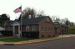 Spring City Borough Hall | |
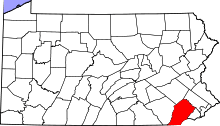
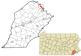 Location in Chester County and the U.S. state of Pennsylvania. | |
 Spring City Location of Spring City in Pennsylvania  Spring City Spring City (the US) | |
| Coordinates: 40°10′40″N 75°32′59″W / 40.17778°N 75.54972°WCoordinates: 40°10′40″N 75°32′59″W / 40.17778°N 75.54972°W | |
| Country | United States |
| State | Pennsylvania |
| County | Chester |
| Area[1] | |
| • Total | 0.82 sq mi (2.13 km2) |
| • Land | 0.77 sq mi (1.99 km2) |
| • Water | 0.05 sq mi (0.14 km2) |
| Elevation | 184 ft (56 m) |
| Population (2010) | |
| • Total | 3,323 |
| • Estimate (2016)[2] | 3,301 |
| • Density | 4,298.18/sq mi (1,660.32/km2) |
| Time zone | UTC-5 (EST) |
| • Summer (DST) | UTC-4 (EDT) |
| ZIP Code | 19475 |
| Area code(s) | 610 and 484 |
| Website | www.springcitypa.gov |
Spring City is a borough in Chester County, Pennsylvania, United States. The population was 3,323 at the 2010 census. Spring City is a member of the Spring-Ford Area School District.
It is situated along the Schuylkill River, which divides Chester and Montgomery counties. Directly across the river is the borough of Royersford.
Geography
Spring City is located at 40°10′40″N 75°32′59″W / 40.17778°N 75.54972°W (40.177866, -75.549828).[3]
According to the United States Census Bureau, the borough has a total area of 0.8 square miles (2.1 km2), of which 0.1 square miles (0.26 km2), or 7.32%, is water.
Demographics
| Historical population | |||
|---|---|---|---|
| Census | Pop. | %± | |
| 1880 | 1,112 | — | |
| 1890 | 1,797 | 61.6% | |
| 1900 | 2,566 | 42.8% | |
| 1910 | 2,880 | 12.2% | |
| 1920 | 2,944 | 2.2% | |
| 1930 | 2,903 | −1.4% | |
| 1940 | 3,022 | 4.1% | |
| 1950 | 3,258 | 7.8% | |
| 1960 | 3,162 | −2.9% | |
| 1970 | 3,578 | 13.2% | |
| 1980 | 3,389 | −5.3% | |
| 1990 | 3,433 | 1.3% | |
| 2000 | 3,305 | −3.7% | |
| 2010 | 3,323 | 0.5% | |
| Est. 2016 | 3,301 | [2] | −0.7% |
| Sources:[4][5][6] | |||
At the 2010 census, the borough was 89.6% non-Hispanic White, 3.6% Black or African American, 0.1% Native American, 1.4% Asian, and 2.6% were two or more races. 3.4% of the population were of Hispanic or Latino ancestry .
As of the census[5] of 2000, there were 3,305 people, 1,412 households, and 835 families residing in the borough. The population density was 4,321.9 people per square mile (1,679.0/km²). There were 1,508 housing units at an average density of 1,972.0 per square mile (766.1/km²). The racial makeup of the borough was 95.25% White, 1.94% African American, 0.51% Native American, 1.03% Asian, 0.06% Pacific Islander, 0.27% from other races, and 0.94% from two or more races. Hispanic or Latino of any race were 1.18% of the population.
There were 1,412 households, out of which 28.6% had children under the age of 18 living with them, 42.8% were married couples living together, 11.4% had a female householder with no husband present, and 40.8% were non-families. 33.9% of all households were made up of individuals, and 8.9% had someone living alone who was 65 years of age or older. The average household size was 2.33 and the average family size was 3.03.
In the borough the population was spread out, with 23.8% under the age of 18, 8.3% from 18 to 24, 34.9% from 25 to 44, 21.7% from 45 to 64, and 11.3% who were 65 years of age or older. The median age was 36 years. For every 100 females there were 102.5 males. For every 100 females age 18 and over, there were 102.0 males.
The median income for a household in the borough was $40,601, and the median income for a family was $52,292. Males had a median income of $36,866 versus $27,054 for females. The per capita income for the borough was $20,931. About 4.1% of families and 6.3% of the population were below the poverty line, including 7.4% of those under age 18 and 4.1% of those age 65 or over.
Notable people
- Sherwood H. Hallman, a recipient of the United States military's highest decoration—the Medal of Honor—for his actions in World War II
- Chuck Sheetz, Emmy Award-winning animation director for The Simpsons
- Ham Wade, Major League Baseball player for the New York Giants
- Walt Weney, Former Drag Racer Founder Of S&W Race Cars
- Scott Weney, Former Professional And Sportsman Drag Racer 2000 IHRA Funny Car Champion Founder Of S&W Race Cars
References
- ↑ "2016 U.S. Gazetteer Files". United States Census Bureau. Retrieved Aug 13, 2017.
- 1 2 "Population and Housing Unit Estimates". Retrieved June 9, 2017.
- ↑ "US Gazetteer files: 2010, 2000, and 1990". United States Census Bureau. 2011-02-12. Retrieved 2011-04-23.
- ↑ "Census of Population and Housing". U.S. Census Bureau. Retrieved 11 December 2013.
- 1 2 "American FactFinder". United States Census Bureau. Retrieved 2008-01-31.
- ↑ "Incorporated Places and Minor Civil Divisions Datasets: Subcounty Resident Population Estimates: April 1, 2010 to July 1, 2012". Population Estimates. U.S. Census Bureau. Archived from the original on 17 June 2013. Retrieved 11 December 2013.