Manheim Township, Lancaster County, Pennsylvania
| Manheim Township, Lancaster County, Pennsylvania | |
|---|---|
| Township | |
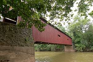 Pinetown Bushong's Mill Covered Bridge over the Conestoga River in Manheim Township. | |
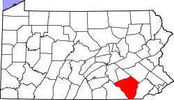
 Map of Lancaster County highlighting Manheim Township | |
| Country | United States |
| State | Pennsylvania |
| County | Lancaster |
| Settled | 1729 |
| Incorporated | 1729 |
| Government | |
| • Type | Board of Commissioners |
| Area[1] | |
| • Total | 24.07 sq mi (62.35 km2) |
| • Land | 23.87 sq mi (61.81 km2) |
| • Water | 0.21 sq mi (0.54 km2) |
| Population (2010) | |
| • Total | 38,133 |
| • Estimate (2016)[2] | 39,893 |
| • Density | 1,671.54/sq mi (645.40/km2) |
| Time zone | UTC-5 (Eastern (EST)) |
| • Summer (DST) | UTC-4 (EDT) |
| Area code(s) | 717 |
| FIPS code | 42-071-46896 |
| Website | Manheim Township |
| Historical population | |||
|---|---|---|---|
| Census | Pop. | %± | |
| 2000 | 33,697 | — | |
| 2010 | 38,133 | 13.2% | |
| Est. 2016 | 39,893 | [2] | 4.6% |
| U.S. Decennial Census[3] | |||
Manheim Township is a township in Lancaster County, Pennsylvania established in 1729, which southernmost border meets the city limits of Lancaster. The population as of the 2010 census was 38,133.
Government
Manheim Township is represented by Republican United States Representative Lloyd Smucker.
Manheim Township is located within Pennsylvania House of Representatives District 97 represented by Republican Steven Mentzer[4] and Pennsylvania Senate District 13 also represented by a Republican, Scott Martin. Residents of Manheim Township elect a five-member Board of Commissioners. Commissioners are elected to serve a four-year term.[5]
Current Board of Commissioners (as of January 2018):[6]
| Commissioner | Party | Electoral History[5] |
|---|---|---|
| David R. Heck | Republican | Elected 11/08/2011; Reelected 11/03/2015[7] |
| Albert B. Kling | Republican | Elected 11/08/2011; Reelected 11/03/2015[7] |
| Donna E. DiMeo | Republican | Elected 11/05/2013; Reelected 11/07/2017[8] |
| Sam Mecum | Democrat | Elected 11/05/2013; Reelected 11/07/2017[8] |
| Tom O'Brien | Democrat | Elected 11/07/2017[8] |
Geography
According to the United States Census Bureau, the township has a total area of 24.3 square miles (62.9 km²), of which, 24.2 square miles (62.7 km²) of it is land and 0.1 square miles (0.2 km²) of it (0.33%) is water.
Manheim Township does not have its own zip code, therefore its residents share postal designations with neighboring municipalities. Residents living in the northernmost parts of the township have a Lititz address, residents living in the central and southern parts of the township have a Lancaster address and residents living in the easternmost parts of the township have a Leola address.[9]
The unincorporated community of Neffsville is located within Manheim Township.
Demographics
As of the census[10] of 2000, there were 33,697 people, 12,961 households, and 9,280 families residing in the township. The population density was 1,391.6 people per square mile (537.4/km²). There were 13,434 housing units at an average density of 554.8/sq mi (214.2/km²). The racial makeup of the township was 93.18% White, 1.46% African American, 0.11% Native American, 3.13% Asian, 0.01% Pacific Islander, 1.02% from other races, and 1.09% from two or more races. Hispanic or Latino of any race were 2.77% of the population.
There were 12,961 households, out of which 31.0% had children under the age of 18 living with them, 63.1% were married couples living together, 6.4% had a female householder with no husband present, and 28.4% were non-families. 24.8% of all households were made up of individuals, and 12.8% had someone living alone who was 65 years of age or older. The average household size was 2.47 and the average family size was 2.96.
In the township the population was spread out, with 23.2% under the age of 18, 5.8% from 18 to 24, 24.9% from 25 to 44, 25.2% from 45 to 64, and 21.0% who were 65 years of age or older. The median age was 43 years. For every 100 females, there were 88.3 males. For every 100 females age 18 and over, there were 83.7 males.
The median annual income for a household in the township was $55,807, and the median annual income for a family was $67,365. Males had a median annual income of $46,940 versus $29,618 for females. The per capita income for the township was $28,730. About 2.4% of families and 4.0% of the population were below the poverty line, including 3.7% of those under age 18 and 6.1% of those age 65 or over.
Education
Students enrolled in public schools attend Manheim Township School District. The district operates the following schools:[11]
- Manheim Township High School
- Manheim Township Virtual High School
- Manheim Township Middle School
- Landis Run Intermediate School
- Brecht Elementary
- Bucher Elementary
- Neff Elementary
- Nitrauer Elementary
- Reidenbaugh Elementary
- Schaeffer Elementary
The Manheim Township Board of School Directors articulates the policy, budgetary direction and vision for the school district. It has nine members, elected to terms of four years each.[12]
Places of interest
Fun Facts About Lancaster County:
Lancaster County has been the site of several notable films, including Home, Corporate Affairs, Rock School, Beloved, and Thomas and the Magic Railroad
See also
References
- ↑ "2016 U.S. Gazetteer Files". United States Census Bureau. Retrieved Aug 14, 2017.
- 1 2 "Population and Housing Unit Estimates". Retrieved June 9, 2017.
- ↑ "Census of Population and Housing". Census.gov. Retrieved June 4, 2016.
- ↑ "Archived copy". Archived from the original on 2014-01-16. Retrieved 2013-08-04.
- 1 2 "Election Returns available". Ice1.co.lancaster.pa.us. Archived from the original on 2012-07-23. Retrieved 2012-11-08.
- ↑ Archived September 25, 2010, at the Wayback Machine.
- 1 2 http://vr.co.lancaster.pa.us/ElectionReturns/November_3,_2015_-_Municipal_Election/369.html
- 1 2 3 http://vr.co.lancaster.pa.us/ElectionReturns/November_7,_2017_-_Municipal_Election/399.html
- ↑ "The United States Postal Service (U.S. Postal Service)". USPS. Retrieved 2012-11-08.
- ↑ "American FactFinder". United States Census Bureau. Retrieved 2008-01-31.
- ↑ "Manheim Township School District | The Mission of the Manheim Township School District is to provide an environment where everyone will learn, grow, and succeed". Mtwp.net. Retrieved 2012-11-08.
- ↑ "Manheim Township School District - School Board". Mtwp.net. Retrieved 2012-11-08.
External links
Coordinates: 40°07′36″N 76°16′59″W / 40.12667°N 76.28306°W