Phelps, Wisconsin
| Phelps, Wisconsin | |
|---|---|
| Town | |
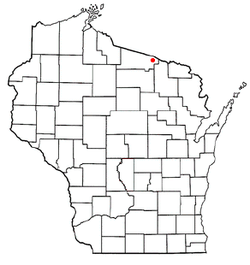 Location of Phelps, Wisconsin | |
| Coordinates: 46°3′36″N 89°5′27″W / 46.06000°N 89.09083°W | |
| Country | United States |
| State | Wisconsin |
| County | Vilas |
| Area | |
| • Total | 108.8 sq mi (281.8 km2) |
| • Land | 94.9 sq mi (245.7 km2) |
| • Water | 14.0 sq mi (36.2 km2) |
| Elevation[1] | 1,736 ft (529 m) |
| Population (2000) | |
| • Total | 1,350 |
| • Density | 14.2/sq mi (5.5/km2) |
| Time zone | UTC-6 (Central (CST)) |
| • Summer (DST) | UTC-5 (CDT) |
| Area code(s) | 715 & 534 |
| FIPS code | 55-62425[2] |
| GNIS feature ID | 1583917[1] |
| Website | http://townofphelps.com/ |
Phelps is a town in Vilas County, Wisconsin, United States. The population was 1,350 at the 2000 census. The unincorporated community of Phelps is located in the town.
Demographics
As of the census[2] of 2000, there were 1,350 people, 560 households, and 411 families residing in the town. The population density was 14.2 people per square mile (5.5/km²). There were 1,605 housing units at an average density of 16.9 per square mile (6.5/km²). The racial makeup of the town was 97.56% White, 1.19% Native American, 0.30% Asian, and 0.96% from two or more races. Hispanic or Latino of any race were 0.81% of the population.
There were 560 households out of which 24.8% had children under the age of 18 living with them, 63.0% were married couples living together, 6.8% had a female householder with no husband present, and 26.6% were non-families. 22.7% of all households were made up of individuals and 12.1% had someone living alone who was 65 years of age or older. The average household size was 2.29 and the average family size was 2.67.
In the town, the population was spread out with 18.4% under the age of 18, 4.4% from 18 to 24, 20.8% from 25 to 44, 28.6% from 45 to 64, and 27.9% who were 65 years of age or older. The median age was 49 years. For every 100 females, there were 95.4 males. For every 100 females age 18 and over, there were 91.3 males.
The median income for a household in the town was $31,574, and the median income for a family was $37,589. Males had a median income of $30,769 versus $21,875 for females. The per capita income for the town was $17,337. About 5.8% of families and 9.2% of the population were below the poverty line, including 14.2% of those under age 18 and 5.1% of those age 65 or over.
Geography
The Town of Phelps is located in the northeast corner of Vilas County along the border with Michigan. The headwaters of the Wisconsin River are in the northwest corner of the town at Lac Vieux Desert. Much of the town is a part of the Chequamegon-Nicolet National Forest. According to the United States Census Bureau, the town has a total area of 108.8 square miles (281.8 km²), of which, 94.9 square miles (245.7 km²) of it is land and 14.0 square miles (36.2 km²) of it (12.83%) is water.
Places adjacent to Phelps, Wisconsin | |
|---|---|
Climate
The climate is described as Humid Continental by the Köppen Climate System, abbreviated as Dfb.[3]
| Climate data for Phelps, Wisconsin | |||||||||||||
|---|---|---|---|---|---|---|---|---|---|---|---|---|---|
| Month | Jan | Feb | Mar | Apr | May | Jun | Jul | Aug | Sep | Oct | Nov | Dec | Year |
| Average high °C (°F) | −7 (20) |
−5 (23) |
3 (37) |
11 (52) |
18 (64) |
23 (73) |
26 (78) |
23 (74) |
19 (67) |
12 (54) |
3 (38) |
−3 (26) |
11 (51) |
| Average low °C (°F) | −19 (−2) |
−19 (−2) |
−14 (7) |
−3 (26) |
2 (35) |
8 (46) |
11 (51) |
8 (47) |
5 (41) |
1 (33) |
−6 (21) |
−13 (8) |
−3 (26) |
| Average precipitation mm (inches) | 30 (1.2) |
30 (1) |
38 (1.5) |
58 (2.3) |
81 (3.2) |
104 (4.1) |
94 (3.7) |
100 (4) |
99 (3.9) |
66 (2.6) |
50 (2) |
36 (1.4) |
782 (30.8) |
| Source: Weatherbase [4] | |||||||||||||
Culture
Several hunting and fishing clubs are located in Phelps, including the historic Big Sand Lake Club. Resorts and recreation centered around the town's many lakes are very popular, as are activities such as hiking and camping in the Chequamegon-Nicolet National Forest. Other events include a large softball tournament held every summer in Wavering Park, and a fireworks display over the lake for Independence Day, of which many people partake from boats.
Phelps was named after William Phelps, a partner in the Hackley, Phelps & Bonnell Company which owned many of the area.[5]
Transportation
Phelps is served by Wisconsin Highway 17 (WIS 17), three Vilas County trunk highways, and a large network of town and Forest Highways. WIS 17 runs southwest–northeast across the town, through the unincorporated community of Phelps and to the Michigan border and a connection to Forest Highway 16 near Smokey Lake. This also provides a connection to Iron River, Michigan, via Iron County Road 436. To the southwest, WIS 17 connects to US Highway 45/WIS 32 and the rest of the Wisconsin State Highway System approximately 4 miles (6.4 km) north of Eagle River. County Trunk Highway E (CTH-E) begins in the Central business district of the unincorporated community of Phelps and runs northwest to serve the area around Lac Vieux Desert before ending at US 45/WIS 32 approximately 2 miles (3.2 km) south of Land o' Lakes. CTH-K follows the north shore of North Twin Lakes and provides a connection to Conover and points west, while CTH-A begins at WIS 17 approximately 1.5 miles (2.4 km) east of the unincorporated community of Phelps and leads south and east to its terminus at WIS 55 in the community of Nelma in Forest County.
References
- 1 2 "US Board on Geographic Names". United States Geological Survey. 2007-10-25. Retrieved 2008-01-31.
- 1 2 "American FactFinder". United States Census Bureau. Retrieved 2008-01-31.
- ↑ Climate Summary for Phelps, Wisconsin
- ↑ "Weatherbase.com". Weatherbase. 2013. Retrieved on August 25, 2013.
- ↑ Gard, Robert E.; Sorden, L. G. The Romance of Wisconsin Place Names. New York, NY: October House. p. 100.
External links
Municipalities and communities of Vilas County, Wisconsin, United States | ||
|---|---|---|
| City |  | |
| Towns | ||
| CDPs | ||
| Unincorporated communities | ||
| Indian reservations | ||
| Footnotes | ‡This populated place also has portions in an adjacent county or counties | |
Coordinates: 46°03′52″N 89°05′15″W / 46.06444°N 89.08750°W