Presque Isle River
| Presque Isle River | |
 Presque Isle River | |
| Country | United States |
|---|---|
| State | Michigan |
| Type | Scenic, Reecreational |
| Designated | March 3, 1992 |
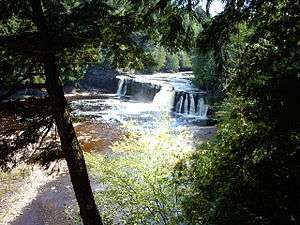
The Presque Isle River runs 42.1 miles (67.8 km) through the Upper Peninsula of Michigan and empties into Lake Superior.[1] Along its course, it flows through the Ottawa National Forest and Porcupine Mountains Wilderness State Park. It has 300 square miles (780 km2) of drainage area in Upper Michigan and northern Wisconsin.
Several waterfalls are located on the river. They include (from west to east):
- Manabezho Falls
- Manido Falls
- Nawadaha Falls
- Iagoo Falls
- Lepisto Falls
- Nokomis Falls
- Nimikon Falls
- Minnewawa Falls
- Yondota Falls
References
- ↑ U.S. Geological Survey. National Hydrography Dataset high-resolution flowline data. The National Map, accessed May 1, 2012
External links
| Wikimedia Commons has media related to Presque Isle River. |
Coordinates: 46°42′38″N 89°58′28″W / 46.71056°N 89.97444°W
This article is issued from
Wikipedia.
The text is licensed under Creative Commons - Attribution - Sharealike.
Additional terms may apply for the media files.