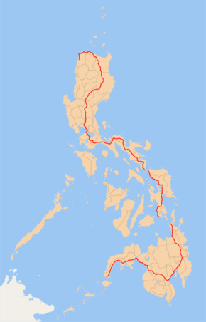
Pan–Philippine Highway
| |
|---|---|
|
Maharlika Highway Asian Highway 26 | |
 | |
| Route information | |
| Maintained by Department of Public Works and Highways - Local District Engineering Offices (DPWH) / Private Sectors (Expressway segments only) | |
| Length | 3,517 km (2,185 mi) |
| Component highways |
|
| Laoag-Caloocan | |
| North end |
|
| Major junctions |
|
| South end |
|
| Muntinlupa-Matnog | |
| North end |
|
| Major junctions |
|
| South end |
|
| Highway system | |
|
Roads in the Philippines | |
_sign.svg.png)
_sign.svg.png)
_sign.svg.png)
_sign.svg.png)
_sign.svg.png)
_sign.svg.png)
The Pan–Philippine Highway, also known as the Maharlika Highway (![]()
The northern terminus of the highway is in Laoag City, Ilocos Norte and the southern terminus is in Zamboanga City.
Development
The highway was proposed in 1965, and built under the Martial Law dictatorship of President Ferdinand Marcos. Government planners believed that the motorway and other connected roads would stimulate agricultural production by reducing transport costs, encourage social and economic development outside existing major urban centres such as Manila, and expand industrial production for domestic and overseas markets. Construction was supported by loans and grants from foreign aid institutions, including the World Bank.
The highway was rehabilitated and improved in 1997, during the Ramos Administration, with assistance from the Japanese government, and dubbed the Philippine-Japan Friendship Highway. In 1998, the Department of Tourism designated 35 sections of the highway as "Scenic Highways", with developed amenities for travellers and tourists.
In March 2018, Secretary Mark Villar of the Department of Public Works and Highways (DPWH) inaugurated the 24.61 -kilometer arterial road that will link the North Luzon Expressway (NLEX) with the Maharlika Highway that traverses the central part of Luzon.[1]
Route
Main Route:
- Gen. Segundo Avenue: Laoag
- Manila North Road/Maharlika Highway: Bacarra - Lal-lo
- Cagayan Valley Road: Lal-lo - Tuguegarao - Ilagan - Santiago - Bayombong - San Jose City - Cabanatuan - Gapan - San Miguel - Baliuag
- Doña Remedios Trinidad Road: Baliuag - Pulilan - Guiguinto - Santa Rita (Guiguinto)
- NLEX: Santa Rita (Guiguinto) - Balintawak (Quezon City) (still unsigned as part of AH26)
- EDSA (Eastern Route): Balintawak (Quezon City) - Magallanes (Makati)
- SLEX: Magallanes (Makati) - Turbina (Calamba)(partially signed as AH26).
- Daang Maharlika/Manila South Road: Turbina (Calamba) - Santo Tomas - Alaminos - San Pablo - Tiaong - Lucena - Daet - Naga City - Sorsogon City - Matnog
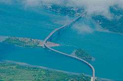
- Ferry from Matnog to Allen
- Allen - Catbalogan - Tacloban - Liloan
- Ferry from Liloan to Surigao City
- Surigao City - Butuan - Bayugan - Tagum - Davao City - Digos - General Santos - Koronadal - Tacurong - Midsayap - Sultan Kudarat - Parang - Malabang - Sultan Naga Dimaporo - Pagadian - Ipil - Zamboanga City
Alternative Route
- C-4 Road, Radial Road 10, Roxas Boulevard, EDSA (Western Route): Balintawak (Quezon City) - Monumento (Caloocan) - Navotas - Ermita (Manila) - Pasay - Magallanes (Makati)
Asian Highway Network
The Pan-Philippine Highway is designated as ![]()
![]()
![]()
![]()
Intersections
Ilocos Norte
Cagayan
.svg.png)
.svg.png)
.svg.png)
Isabela
Nueva Vizcaya
Nueva Ecija
.svg.png)
.svg.png)
.svg.png)
.svg.png)
.svg.png)
Bulacan
Metro Manila
.svg.png)
Eastern route
Western route
SLEX section
Cavite
Laguna (1st segment)
.svg.png)
.svg.png)
.svg.png)
Batangas
.svg.png)
.svg.png)
Laguna (2nd segment)
.svg.png)
Quezon
Camarines Norte
Camarines Sur
Albay
Sorsogon
.svg.png)
.svg.png)
.svg.png)
.svg.png)
.svg.png)
Luzon–Visayas boundary

Northern Samar
.svg.png)
Samar
.svg.png)
.svg.png)
.svg.png)
.svg.png)
.svg.png)
Samar–Leyte boundary
Zamboanga del Sur
Zamboanga Sibugay
Compostela Valley
.svg.png)
.svg.png)
Davao del Norte
Davao Del Sur
Sultan Kudarat
South Cotabato
.svg.png)
.svg.png)
Surigao del Norte
Agusan del Norte
Agusan del Sur
.svg.png)
.svg.png)
.svg.png)
.svg.png)
Maguindanao
Gallery
- Selected segments of the Pan-Philippine Highway
_(EDSA-North_Triangle%2C_Quezon_City%3B_2017-02-22).jpg) AH26 reassurance sign along EDSA in Quezon City
AH26 reassurance sign along EDSA in Quezon City.JPG) Reassurance sign for Pan-Philippine Highway/AH26 at South Luzon Expressway-Sta. Rosa City, Laguna segment.
Reassurance sign for Pan-Philippine Highway/AH26 at South Luzon Expressway-Sta. Rosa City, Laguna segment.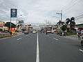 The segment in Santo Tomas, Batangas.
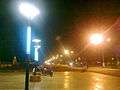 Narra Avenue, segment of AH26 in Bayugan City, Agusan del Sur
See also
References
- http://www.bookrags.com/history/worldhistory/pan-philippine-highway-ema-04/
- http://manilarat.blogspot.com/2005/11/philippine-tourism-highway.html
- https://web.archive.org/web/20060619230039/http://www.philippineembassy-usa.org/about/economy.htm
- http://www.rappler.com/newsbreak/iq/74846-ah26-road-sign
- http://www.dpwh.gov.ph/pdf/issuances/DO/09/DO_015_S2009.pdf
- ↑ "North Luzon expressway, Maharlika highway linked". Manila Bulletin. Retrieved October 9, 2018.
External links
| Wikimedia Commons has media related to Pan-Philippine Highway. |
| National primary roads |
| |||||||
|---|---|---|---|---|---|---|---|---|
| National secondary roads |
| |||||||
See also: Philippine expressway network | ||||||||
| Across the whole continent | 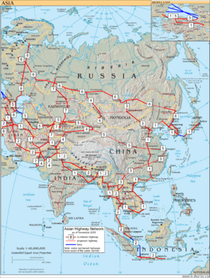 | |
|---|---|---|
| Southeast Asia | ||
| East Asia, Northeast Asia and Southeast Asia | ||
| South Asia | ||
| North Asia, Central Asia and Southwest Asia | ||