NAIA Road
| |
|---|---|
| MIA Road | |
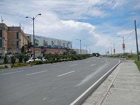 2013 photo of NAIA Road, west of Roxas Boulevard, prior to the construction of NAIA Expressway | |
| Route information | |
| Length | 2.5 km (1.6 mi) |
| Major junctions | |
| West end | Macapagal Boulevard in Bay City |
| East end | Ninoy Aquino International Airport Terminal 2 |
| Location | |
| Major cities | Pasay and Parañaque |
| Highway system | |
|
Roads in the Philippines | |
.svg.png)
NAIA Road (Ninoy Aquino International Airport Road), formerly known and still commonly referred to as MIA Road (Manila International Airport Road), is a short 8-10 lane divided highway connecting Roxas Boulevard and the Manila–Cavite Expressway (R-1) with Ninoy Aquino International Airport (NAIA) in southwestern Metro Manila, Philippines. It is also a major local road that links the cities of Pasay and Parañaque running approximately 2.5 kilometers (1.6 miles) underneath the elevated NAIA Expressway from its westernmost point at the junction with Macapagal Boulevard in Bay City, Barangay Tambo, Parañaque to the NAIA Terminal 2 in Pasay. En route, it intersects, from west to east, Roxas Boulevard, Elpidio Quirino Avenue, Domestic Road and Ninoy Aquino Avenue. The road ends at the entrance to the airport terminal 2.
The Southwest Integrated Terminal for buses bound for Cavite and western Batangas provinces is situated on NAIA Road at the junction with Macapagal Boulevard in Coastal Mall.[1] The road also houses a small strip of shops across from Coastal Mall, Tambo Elementary School at Quirino, Park 'N Fly at Domestic and the old Nayong Pilipino close to Terminal 2. The old NAIA Terminal 1 is accessible by turning south at Ninoy Aquino Avenue which also leads to the Duty Free FiestaMall, and continues on to Sucat as Dr. Santos Avenue. The new Terminal 3, on the other hand, is located on Andrews Avenue which can be accessed from Domestic Road. The road was originally MIA Road and was only renamed in 1987 when Manila's international airport became Ninoy Aquino International.
NAIA Expressway runs through NAIA Road from the Sales Interchange of the Skyway to the junction of NAIA Road and Macapagal Boulevard via Andrews Avenue and Electrical Road, providing better access to all four terminals of the Ninoy Aquino airport as well as the casino complex in Entertainment City.[2]
References
- ↑ Cavite, Batangas buses stop at Parañaque terminal starting Aug 6 published by Rappler; accessed 2013-10-19.
- ↑ NAIA Expressway project breaks ground published by the Philippine Daily Inquirer; accessed 2013-10-29.
Coordinates: 14°31′0″N 120°59′59″E / 14.51667°N 120.99972°E