Pagbilao
| Pagbilao | |
|---|---|
| Municipality | |
| Municipality of Pagbilao | |
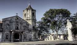 Saint Catherine of Alexandria Church | |
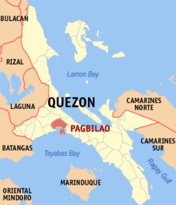 Map of Quezon with Pagbilao highlighted | |
.svg.png) Pagbilao Location within the Philippines | |
| Coordinates: 13°58′N 121°42′E / 13.97°N 121.7°ECoordinates: 13°58′N 121°42′E / 13.97°N 121.7°E | |
| Country |
|
| Region | Calabarzon (Region IV-A) |
| Province | Quezon |
| District | 1st District |
| Founded | August 29, 1730 |
| Barangays | 27 (see Barangays) |
| Government [1] | |
| • Type | Sangguniang Bayan |
| • Mayor | Shierre Ann Portes-Palicpic |
| • Electorate | 38,936 voters (2016) |
| Area [2] | |
| • Total | 170.96 km2 (66.01 sq mi) |
| Population (2015 census)[3] | |
| • Total | 75,023 |
| • Density | 440/km2 (1,100/sq mi) |
| Time zone | UTC+8 (PST) |
| ZIP code | 4302 |
| PSGC | 045630000 |
| IDD : area code | +63 (0)42 |
| Climate type | Tropical rainforest climate |
| Income class | 1st municipal income class |
| Revenue (₱) | 216,889,800.02 (2016) |
| Native languages | Tagalog |
| Website |
www |
Pagbilao, officially the Municipality of Pagbilao, (Tagalog: Bayan ng Pagbilao), is a 1st class municipality in the province of Quezon, Philippines. According to the 2015 census, it has a population of 75,023 people.[3]
It is located on the northern shore of Tayabas Bay on Luzon, just east of Lucena City, the provincial capital.
Barangays
Pagbilao is politically subdivided into 27 barangays.
- Alupaye
- Añato
- Antipolo
- Bantigue
- Bigo
- Binahaan
- Bukal
- Ibabang Bagumbungan
- Ibabang Palsabangon (detour)
- Ibabang Polo.
- Ikirin
- Ilayang Bagumbungan
- Ilayang Palsabangon
- Ilayang Polo
- Kanlurang Malicboy
- Mapagong
- Mayhay
- Pinagbayanan
- Barangay 1 Castillo (Poblacion)
- Barangay 2 Daungan (Poblacion)
- Barangay 3 Del Carmen (Poblacion)
- Barangay 4 Parang (Poblacion)
- Barangay 5 Santa Catalina (Poblacion)
- Barangay 6 Tambak (Poblacion)
- Silangang Malicboy
- Talipan
- Tukalan
- Tambak
Demographics
| Population census of Pagbilao | ||
|---|---|---|
| Year | Pop. | ±% p.a. |
| 1903 | 6,085 | — |
| 1918 | 6,879 | +0.82% |
| 1939 | 11,379 | +2.43% |
| 1948 | 12,978 | +1.47% |
| 1960 | 17,303 | +2.43% |
| 1970 | 26,587 | +4.38% |
| 1975 | 29,304 | +1.97% |
| 1980 | 31,681 | +1.57% |
| 1990 | 41,635 | +2.77% |
| 1995 | 49,605 | +3.34% |
| 2000 | 53,442 | +1.61% |
| 2007 | 62,561 | +2.20% |
| 2010 | 65,996 | +1.96% |
| 2015 | 75,023 | +2.47% |
| Source: Philippine Statistics Authority[3][4][5][6] | ||
Government
Elected officials 2016–2019:
- Mayor: Shierre Ann Portes-Palicpic
- Vice Mayor: Joseph C. Garcia
- Councilors:
- Ariel T. Martinez
- Veranio R. Fuentes
- Jeffrey A. Tiñana
- Apolinar R. Martinez
- Joahness R. Mercado
- Lolito M. Merle
- Celedonio C. Dapla
- Jacinto A. Piñon
- Maria Assumpta Z. Ariate
Economy
Most of the vast lands of Pagbilao are mainly used for agricultural. These agricultural land are mostly coconut, rice and poultry farms. But some of these lands became industrial areas. Most of these industrial lands are ice plants, rice and oil mills which can be seen along the highway.
The Province of Quezon announced that they are planning to make an industrial park or economic zone in the Barangays of Alupaye and Bantigue of Pagbilao. It will really help the employment of the people of Quezon Province.
Commerce is also rapidly grown not only in the downtown area, but also spreading in the whole town. Commercial establishments are growing from Talipan up to downtown along the highway. La Suerte Mega Warehouse, the largest commercial center in town, is found in Alupaye, which most of the bus terminals can be found here.
Tourism is also growing in Pagbilao. There are many hotel and resorts can be found along the highway or in the beachfront of Barangay Bantigue, which has a great view of the islands of the town.
The DEPED-Division of Quezon Province has its main office in town. It is one of largest employers not only in Pagbilao, but the whole Quezon Province. The municipal government is also one of the top employers in town, which focuses on public services.
The Pagbilao Coal Power Plant, one of the Philippine's largest power plant stations, is found on Isla Grande in Pagbilao. It is said to be the largest employer in town.
Education
Pagbilao has numerous primary and secondary educational institutions. The following are:
- Bagumbungan Elementary School
- Bantigue Elementary School
- Bigo Elementary School
- Binahaan Elementary School
- Bukal Elementary School
- Malicboy East Elementary School
- Malicboy West Elementary School
- Mapagong-Alupaye Elementary School
- Pagbilao Central Elementary School
- Pagbilao East Elementary School
- Pagbilao West Elementary School
- Palsabangon Elementary School
- Parang-Pinagbayanan Elementary School
- Polo North Elementary School
- Polo South Elementary School
- Talipan Elementary School
Secondary Schools
- Pagbilao Grande Island National High School
- Silangang Malicboy National High School
- Pagbilao National High School
- Talipan National High School
Tertiary Schools
- Quezon National Agricultural School
Private Schools
- Alcastle Educational School, Inc.
- Casa del Niño Jesus de Pagbilao
- Pagbilao Family Kiddie School
- Lord's Angel Learning School
- Pagbilao Academy, Inc.
Communications
Pagbilao has numerous mobile phone, internet and cable services providers. The following are:
References
- ↑ "Municipality". Quezon City, Philippines: Department of the Interior and Local Government. Retrieved 31 May 2013.
- ↑ "Province: Quezon". PSGC Interactive. Quezon City, Philippines: Philippine Statistics Authority. Retrieved 12 November 2016.
- 1 2 3 Census of Population (2015). "Region IV-A (Calabarzon)". Total Population by Province, City, Municipality and Barangay. PSA. Retrieved 20 June 2016.
- ↑ Census of Population and Housing (2010). "Region IV-A (Calabarzon)". Total Population by Province, City, Municipality and Barangay. NSO. Retrieved 29 June 2016.
- ↑ Censuses of Population (1903–2007). "Region IV-A (Calabarzon)". Table 1. Population Enumerated in Various Censuses by Province/Highly Urbanized City: 1903 to 2007. NSO.
- ↑ "Province of Quezon". Municipality Population Data. Local Water Utilities Administration Research Division. Retrieved 17 December 2016.
External links
| Wikimedia Commons has media related to Pagbilao. |
- The Official Website of the Municipality of Pagbilao, Quezon
- Philippine Standard Geographic Code
- Philippine Census Information
- Local Governance Performance Management System
- People of Pagbilao
- Pagbilao Sceneries by Gerry B. Lontok
- Welcome to Quezon Province -- www.goquezon.com
- Quezon Province Web Portal
Places adjacent to Pagbilao | ||||||||||
|---|---|---|---|---|---|---|---|---|---|---|
| ||||||||||
Lucena (capital) | |
| Municipalities |
|
| Component city | |
| Highly urbanized city |
|