Midsayap–Marbel Road
| ||||
|---|---|---|---|---|
| Makar–Dulawan–Midsayap–Marbel Road | ||||
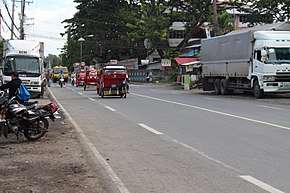 Section of the Midsayap–Marbel Road at Midsayap | ||||
| Route information | ||||
| Maintained by Department of Public Works and Highways | ||||
| Length | 101 km (63 mi) | |||
| Component highways | ||||
| Major junctions | ||||
| From |
| |||
|
| ||||
| To |
| |||
| Location | ||||
| Major cities | Tacurong, Koronadal | |||
| Towns | Midsayap, Datu Piang, Datu Saudi-Ampatuan, Mamasapano, Rajah Buayan, Sultan Sa Barongis, Lambayong, Tantangan | |||
| Highway system | ||||
|
Roads in the Philippines
| ||||
.svg.png)
The Midsayap–Marbel Road, also known as Makar–Dulawan–Midsayap–Marbel Road is a 101-kilometre (63 mi), two-to-four lane highway that connects the provinces of North Cotabato,[1] Maguindanao, Sultan Kudarat,[2] and South Cotabato.[3] It is classified as a national secondary highway for Mindanao. It lessens the travel time from North Cotabato to South Cotabato and Sultan Kudarat via Midsayap.
This highway is a designated component of the National Route 940 (N940) of the Philippine highway network.
References
- ↑ "Cotabato 2nd". www.dpwh.gov.ph. Retrieved 2018-08-27.
- ↑ "Sultan Kudarat 1st". www.dpwh.gov.ph. Retrieved 2018-08-27.
- ↑ "South Cotabato 1st". www.dpwh.gov.ph. Retrieved 2018-08-27.
| National primary roads |
| |||||||
|---|---|---|---|---|---|---|---|---|
| National secondary roads |
| |||||||
See also: Philippine expressway network | ||||||||
This article is issued from
Wikipedia.
The text is licensed under Creative Commons - Attribution - Sharealike.
Additional terms may apply for the media files.