Ermita
| Ermita | |
|---|---|
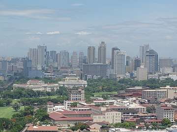 The skyline of Ermita with Intramuros in the foreground | |
 Location within Manila | |
| Country | Philippines |
| Region | National Capital Region |
| City | Manila |
| Congressional District | 5th District |
| Area | |
| • Total | 1.59 km2 (0.61 sq mi) |
| Population (2015)[1] | |
| • Total | 10,523 |
| Time zone | UTC+08:00 (Philippine Standard Time) |
Ermita is a district in Manila, Philippines. It is a significant center of finance, education, culture and commerce. Ermita serves as the civic center of the city, bearing the seat of city government and a large portion of the area's employment, business, and entertainment activities.
Private and government offices, museums, and university thrive in Ermita. It is also the home to famous tourist attractions and landmarks, among them is the Rizal Park, the premier national park of the Philippines.
History
Ermita was founded in the late 16th century. Its name was taken from La Hermita, the Spanish word for "hermitage", after the fact that a Mexican hermit resided in the area and on this site was built a hermitage housing an image of the Virgin Mary known as the Nuestra Señora de Guia (Our Lady of Guidance). The hermitage has since evolved into Ermita Church, which has been rebuilt several times since the early 17th century.[2]
Ermita gained renewed prominence during the American colonial period. It became known as the university district, containing the campuses and dormitories of the Philippine Normal University,[3] University of the Philippines, the Ateneo de Manila, Adamson University, the Assumption College and St. Paul College. The residential portion of Ermita was populated by American residents, who set up such establishments as the Army and Navy Club, and the University Club.[4]
During the early half of the 20th century, the Ermita district as well as its adjacent district, Malate became known for the gilded mansions built by the upper classes. The richest people then lived in the two neighborhoods who are both facing the Manila Bay.
In February 1945, during the 1945 Battle of Manila, Ermita was the scene of some of the most horrific massacres that occurred during the Second World War. The wife and four children of future President Elpidio Quirino were murdered in Ermita, as was Supreme Court Associate Justice Anacleto Diaz. Between 68% to 85% of Ermita was destroyed during the Battle of Manila, with an estimated total of 100,000 Filipino civilians killed in the city itself.[5]
After the war, the district slowly transformed from a residential area into a commercial area as the upper classes moved to other cities such as Quezon City and Makati City.
Ermita was rebuilt after the devastation of the war. University life remained vibrant therein. However, as decades passed, Ermita started earning a reputation as the red-light district of Manila.[6] During the first term of Mayor Alfredo Lim, 1992-1998, an effort was made to "clean up" Ermita's image and reputation. However, a local city ordinance prohibiting the establishment of motels, lodging houses and other similar establishments, was later declared unconstitutional by the Supreme Court.[7] As a result of the clean-up efforts, nightlife in the area dwindled though it later picked up with the help of the emergence of the nearby Malate district and the Roxas Boulevard revitalization efforts along Manila Bay.
Accessibility
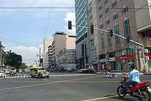
The district can be directly accessed by the main roads like the Roxas Boulevard, Padre Burgos Street, Taft Avenue and United Nations Avenue. The "Park N Ride" Lawton Bus Station, the city's main public transport hub, is located in the district along Padre Burgos Street.
The Manila Light Rail Transit System (LRT-1) follows Taft Avenue and stops at three stations located in Ermita, Central Terminal Station, United Nations Station and Pedro Gil Station.
Economy
Government offices
Ermita is known as the civic center of Manila. The city government is housed in the Manila City Hall along Padre Burgos Street. The offices of the judicial department of the Philippine government is located in the district along Taft Avenue and Padre Faura Street. The Supreme Court of the Philippines, the Court of Appeals, the National Bureau of Investigation, the Department of Justice, and the Boy Scouts of the Philippines are headquartered in this area.
Corporate offices
Ermita is home of the country's major maritime and travel companies which can be found along Kalaw and UN Avenues. Philam Life Insurance Company is headquartered in its building along United Nations Avenue. The Daily Tribune has its publishing house in the area along Kalaw Avenue. Moldex Realty Inc., the largest real estate developer in the city, is headquartered in 1322 Golden Empire Tower, the tallest building in the City of Manila which is along Roxas Boulevard. The Philippine Amusement and Gaming Corporation is also headquartered along Roxas Boulevard.
Commercial centers
Ermita is really a shopping destination for Manila's upper and middle-class families and for students studying in the University Belt. Robinsons Place Manila, Manila's largest shopping mall, is located in the district's tourist belt along Pedro Gil and Adriatico Streets. SM City Manila, on the other hand, is located in the district's civic center along Mayor Antonio Villegas Road. It is also home of the city's hotels, casinos and night clubs. And it is part of Manila's tourist belt along Roxas Boulevard with Malate.
Facilities

Recreation
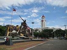
Rizal Park,the widest open urban public park in the country and location of the monument to the national hero José Rizal, is a prominent feature of Ermita. This was the original site for Burnham's planned government center and capitol building. Other sites of interest in Ermita include:
- National Museum of Fine Arts
- National Museum of Anthropology
- National Museum of Natural History
- National Library of the Philippines
- National Archives of the Philippines
- Quirino Grandstand
- Manila Ocean Park
- Liwasang Bonifacio
- Arroceros Forest Park
- Metropolitan Theater
- Manila Hotel
- The Masonic Temple of Ermita
- Philippine Independent Church
- San Vicente de Paul Church
- Ermita Church
- Philippine General Hospital, the country's largest hospital
Education
A number of educational institutions are also found in Ermita, including:
Barangays
Ermita is made up of 13 Barangays numbered 659, 659-A, 660, 660-A, 661, 663, 663-A, 664, 666, 667, 668, 669, and 670.
| Barangay | Population (2015)[1] |
|---|---|
| Barangay 659 | 413 |
| Barangay 659-A | 1,401 |
| Barangay 660 | 490 |
| Barangay 660-A | 553 |
| Barangay 661 | 331 |
| Barangay 663 | 436 |
| Barangay 663-A | 370 |
| Barangay 664 | 202 |
| Barangay 666 | 524 |
| Barangay 667 | 1,238 |
| Barangay 668 | 1,223 |
| Barangay 669 | 1,904 |
| Barangay 670 | 1,438 |
References
| Wikimedia Commons has media related to Ermita, Manila. |
| Wikivoyage has a travel guide for Ermita. |
- Aluit, Alfonso (1994). "The Christian City". By Sword and Fire: The Destruction of Manila in World War II 3 February - 3 March 1945. Philippines: National Commission for Culture and the Arts. pp. 85–89. ISBN 971-8521-10-0.
- 1 2 "Highlights of the Philippine Population 2015 Census of Population". Philippine Statistics Authority. Retrieved July 11, 2017.
- ↑ By Sword and Fire: The Destruction of Manila in World War II 3 February - 3 March 1945, p. 85-86
- ↑ pnu.edu.ph
- ↑ By Sword and Fire: The Destruction of Manila in World War II 3 February - 3 March 1945, p. 89
- ↑ By Sword and Fire: The Destruction of Manila in World War II 3 February - 3 March 1945, p. 405
- ↑ Leo van der Velden, Tussen Prostituee en Maitresse, de Hospitality Girls van Ermita, Manila, 1982, ASC-VAZZOA Universiteit van Amsterdam http://www.scriptiesonline.uba.uva.nl/en/scriptie/573463
- ↑ G.R. No. 118127. April 12, 2005 (archived from the original on 2008-02-24)
| Topics |  | |
|---|---|---|
| Government |
| |
| Districts | ||
| Congressional Districts | ||
| ||