Makilala–Allah Valley Road
| ||||
|---|---|---|---|---|
| Digos–Sultan Kudarat Road | ||||
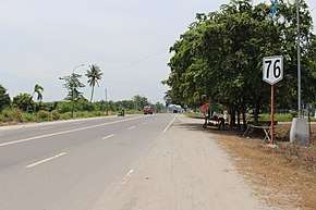 Reassurance Marker at Isulan, Sultan Kudarat | ||||
| Route information | ||||
| Maintained by Department of Public Works and Highways | ||||
| Length | 72 km (45 mi) | |||
| Component highways | ||||
| Major junctions | ||||
| From |
| |||
| To | National Highway in Isulan | |||
| Location | ||||
| Major cities | Tacurong City | |||
| Towns | Makilala, M'lang, Tulunan, Datu Paglas, Buluan, President Quirino, Sultan Kudarat, Isulan | |||
| Highway system | ||||
|
Roads in the Philippines
| ||||
.svg.png)
The Makilala–Allah Valley Road, is a 72-kilometre (45 mi) two-to-four lane highway that connects the provinces of North Cotabato,[1] Maguindanao, and Sultan Kudarat.[2] It is classified as a national primary highway for Mindanao. It also connects to the Maharlika Highway in Tacurong City. It lessens the travel time from North Cotabato to Sultan Kudarat.
This highway is designated as the National Route 76 (N76) of the Philippine highway network.
Intersections
Intersections are numbered by kilometre post, with the Marawi city proper designated as kilometre 0.
| Province | City/Municipality | km | mi | Destinations | Notes |
|---|---|---|---|---|---|
| Sultan Kudarat | Tacurong | Roundabout | |||
| 1.000 mi = 1.609 km; 1.000 km = 0.621 mi | |||||
References
- ↑ "Cotabato 1st". www.dpwh.gov.ph. Retrieved 2018-08-04.
- ↑ "Sultan Kudarat 1st". www.dpwh.gov.ph. Retrieved 2018-08-04.
| National primary roads |
| |||||||
|---|---|---|---|---|---|---|---|---|
| National secondary roads |
| |||||||
See also: Philippine expressway network | ||||||||
This article is issued from
Wikipedia.
The text is licensed under Creative Commons - Attribution - Sharealike.
Additional terms may apply for the media files.