Marikina–Infanta Highway
| |
|---|---|
|
Marcos Highway MARILAQUE Highway | |
 | |
| Route information | |
| Length | 110.0 km (68.4 mi) |
| Component highways |
|
| Major junctions | |
| West end |
|
|
| |
| East end |
|
| Location | |
| Provinces | Metro Manila, Rizal, Quezon |
| Major cities | Pasig, Marikina, Antipolo |
| Towns | Cainta, Tanay, Infanta |
| Highway system | |
|
Roads in the Philippines | |
.svg.png)
The Marikina–Infanta Highway, also known as the Marcos Highway or MARILAQUE Highway (MARILAQUE stands for Manila-Rizal-Laguna-Quezon), is a scenic mountain 110-kilometer highway that connects Metro Manila with Infanta, Quezon in the Philippines.
The highway starts in Marikina near Katipunan Avenue, the Loyola Heights segment of Circumferential Road 5, in Quezon City. It traverses the Marikina Valley and passes through Antipolo, where it intersects the Sumulong Highway (at Masinag). After Masinag the road starts its ascent towards the Sierra Madre passing through Tanay, Rizal, Santa Maria, Laguna, finally to Infanta, Quezon.
Route description
Greater Manila Area Segment (Until Masinag Junction)
Marikina—Infanta Highway starts as a physical continuation of Aurora Boulevard under Katipunan Flyover. The highway slightly curves at the intersection with Andres Bonifacio Avenue connecting the Marikina city proper, then crosses the Marikina River. The Diosdado B. Macapagal Bridge that connects with C-5 merges in front of SM City Marikina. The Manila Light Rail Transit System Line 2 and the Cainta - Marikina subtransmission line of Meralco parallel the highway. The highway makes another slight curve at the approach to Cainta. It soon runs over the Cainta-Marikina boundary, and then goes straight towards the Cainta-Antipolo boundary towards the Masinag Junction with Sumulong Highway wherein it continues on to Cogeo towards the rest of the Rizal Province.
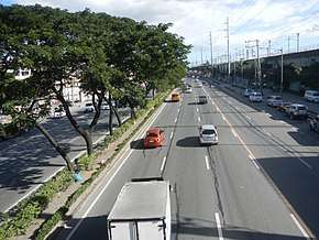
This section, commonly called Marcos Highway, is a divided road featuring U-turn slots, and bike lanes. Several establishments, like the Riverbanks Center, SM City Marikina, Ayala Malls Feliz, Robinsons Metro East, Sta. Lucia East Grand Mall, and SM City Masinag are primary landmarks accessible through the road. Meralco subtransmission lines line the Cainta-Masinag segment of the highway.
Rizal-Laguna-Quezon Segment
This stretch of the highway is a standard 2-6 lane road divided by lane markings typical of national highways located in the provinces. Road size varies depending on the density of the location as well as the engineering district wherein numerous road widening may occur as determined by the DPWH. The road ends and merges with Famy–Real–Infanta Road (Route 601).
Route numbers
Since 2014 with the implementation of the new route numbering system by the Department of Public Works and Highways (DPWH), it is the component of National Route 59 (N59) of the Philippine highway network in the Greater Manila Area. From Rizal to Quezon, the road remains unnumbered and identified as a tertiary national road.
History
Marikina—Infanta Road existed far back to the American colonial era as Highway 55 and Manila-Infanta Highway, which included present-day Recto Avenue, Legarda Street, Magsaysay Boulevard and Aurora Boulevard.
Intersections
| Province | City/Municipality | km[1] | mi | Destinations | Notes |
|---|---|---|---|---|---|
| Marikina | Traffic light intersection. Continues westward to Quezon City as Aurora Boulevard | ||||
| A. Bonifacio Avenue | Eastbound ramp, and westbound at-grade intersection. Access to Marikina-Infanta Highway eastbound via U-turn slot. | ||||
| FVR Road / Riverbanks Avenue | Modified segregated interchange. | ||||
| Marikina River | Marcos Bridge | ||||
| Marikina | SM City Marikina Access Road | Westbound access only. Access to SM City Marikina | |||
| Diosdado Macapagal Bridge / Fernando Avenue | Diosdado Macapagal Bridge - Fernando Avenue Interchange. Towards FVR Road and Fernando Avenue. | ||||
| Marikina–Pasig boundary | |||||
| Pasig | Eulogio Amang Rodriguez Avenue / J.P. Rizal Street | Eastbound/westbound access only. Access from opposite direction via U-turn slot. | |||
| Pasig–Marikina boundary | Nicanor Roxas Street / Emerald Drive / F. Mariano Avenue | Eastbound/westbound access only. Access from opposite direction via U-turn slot. | |||
| Pasig | Robinsons Metro East Access Road | Eastbound access only. Access to Robinsons Metro East. | |||
| Metro Manila–Rizal boundary | Pasig–Cainta boundary | ||||
| Rizal | Cainta | Sta. Lucia East Access Road | Eastbound access only. Access to Sta. Lucia East Grand Mall. | ||
| Metro Manila–Rizal boundary | Marikina–Cainta boundary | Felix Avenue / Gil Fernando Avenue | Access from opposite directions via U-turn slot. Former traffic light intersection. | ||
| Rizal | Cainta–Antipolo boundary | ||||
| Antipolo | Golden Meadows Avenue | Eastbound access only. | |||
| SM City Masinag Access Road | Westbound access only. Access to SM City Masinag | ||||
| Traffic light intersection. Also known as Masinag Junction | |||||
| Quezon | Infanta | ||||
| 1.000 mi = 1.609 km; 1.000 km = 0.621 mi | |||||
Points of interest
Greater Manila Area (inclusive of Cainta and Antipolo)
- Riverbanks Center, Barangka, Marikina City
- SM City Marikina, Calumpang, Marikina City
- Santolan LRT Station, Calumpang, Marikina City
- Bali Oasis Residence, Santolan, Pasig City
- Ayala Malls Feliz, Dela Paz, Pasig City
- Emerald LRT Station, San Roque, Marikina City
- Robinsons Metro East, Dela Paz, Pasig City
- Sta. Lucia East Grand Mall, San Isidro, Cainta, Rizal
- Q-Plaza Square, San Isidro, Cainta, Rizal
- Town and Country Executive Village, San Isidro, Cainta, Rizal
- APT Studios, San Isidro, Cainta, Rizal
- Filinvest Homes East, Mayamot, Antipolo City
- SM City Masinag, Mayamot, Antipolo City
- Masinag LRT Station, Mayamot, Antipolo City
- Masinag Market, Mayamot, Antipolo City
- SM Cherry Antipolo, Mayamot, Antipolo City
- Peña Francia Market, Mayamot, Antipolo City
- Heaven's Gate, Mayamot, Antipolo City
- Cogeo Town Plaza, Sta. Cruz, Antipolo City
- Forest Hills, Sta. Cruz, Antipolo City
- Providence Memorial Park, Calawis, Antipolo City
- Wrigley Philippines, Puting Bato, Antipolo City
- Boso-Boso Highlands, San Jose, Antipolo City
Rizal-Laguna-Quezon Area
- Ten Cents to Heaven, Mayagay, Tanay
- Sierra Madre Mountain Resort, Mayagay, Sampaloc, Tanay
- The Loop Garden Resort, Mayagay, Tanay
- Pranjetto Hills Resort, Mayagay, Sampaloc, Tanay
- Tanay Adventure Camp, Sampaloc, Tanay
- University of Rizal System Main Campus, Sampaloc, Tanay
- Camp Capinpin, Sampaloc, Tanay
- Regina RICA (Regina Rosarii Institute of Contemplation in Asia) Sampaloc, Tanay
- Silangan Railway Express
- Sierra Madre Mountain Ranges
- Cafe Katerina, Tanay, Rizal
- Big C, Tanay, Rizal
- Masungi Georeserve, Tanay, Rizal
- Mang Frank's Bulalo, Tanay, Rizal
- BNK Cafe & Resto, Tanay, Rizal
Template:Commons m
References
- ↑ "North Manila". 2016 DPWH data. Department of Public Works and Highways. Retrieved August 13, 2017.
| Expressways |
| ||||||
|---|---|---|---|---|---|---|---|
| National Roads |
| ||||||
| Expressways |
| ||||||
|---|---|---|---|---|---|---|---|
| National highways |
| ||||||
| Provincial roads and other major roads |
| ||||||
Coordinates: 14°36′49″N 121°20′8″E / 14.61361°N 121.33556°E