Marcos Road
| ||||
|---|---|---|---|---|
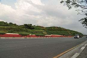 The road near Smokey Mountain | ||||
| Route information | ||||
| Length | 6.2 km (3.9 mi) | |||
| Component highways | ||||
| Major junctions | ||||
| North end | Circumferential Road 4 in Navotas | |||
|
Lapu-Lapu Avenue Circumferential Road 3 Capulong Street Moriones Street | ||||
| South end | Recto Avenue in San Nicolas | |||
| Location | ||||
| Major cities | Malabon, Navotas, Manila | |||
| Highway system | ||||
|
Roads in the Philippines
| ||||
.svg.png)
The Marcos Road, is a 6.2-kilometre (3.9 mi), six-to-ten lane divided highway in northern Manila, Philippines connecting Recto Avenue in San Nicolas district with Circumferential Road 4 in Navotas in the north. The highway is an extension of Bonifacio Drive and Roxas Boulevard (Radial Road 1 or R-1) north of the Pasig River running north-south through the Manila North Port area serving the coastal Tondo and Navotas communities.
History
Radial Road 10 was built on reclaimed land called Tondo Foreshoreland, reclaimed in the 1950s as part of a government plan to expand and improve port facilities in Manila. It soon became the resettlement site of thousands of urban poor families that turned the area into what was once Southeast Asia's largest squatter colony.[1] The road itself was constructed between 1976 and 1979 as part of the Manila Urban Development Project of the Marcos administration.[2]
In January 2017, a bill was filed in the Philippine House of Representatives changing the name of this portion of Radial Road 10 to Mayor Gemiliano Lopez Boulevard in honor of the late Manila mayor Mel Lopez.[3] This bill authored by Buhay Party-List Representative and former Manila mayor Lito Atienza is still pending in the Committee of Public Works and Highways as of February 2017.
Route
Marcos Road originates at the intersection with Recto Avenue as a continuation of Bonifacio Drive from Roxas Bridge (formerly Del Pan Bridge) in San Nicolas. It heads northwest toward Pier 4 of the Manila North Harbor before bending north into the Moriones and Don Bosco villages of Tondo. The road passes east of the entire Manila North Port terminal complex and leaves Barrio Magsaysay for Barrio Vitas past Capulong Street. Continuing north, it soon crosses over the Estero de Vitas (Vitas Creek) and enters the Balut area of Tondo where the old dumpsite of Smokey Mountain is located. North of Estero de Sunog Apog (Sunog Apog Creek), the road extends into the reclaimed fish port complex of Navotas running parallel to North Bay Boulevard. It terminates at Bangkulasi Bridge over the Bangkulasi Channel before the road turns east as Circumferential Road 4 (C-4) which heads to Malabon and South Caloocan.
Landmarks

- Amado Hernandez Elementary School
- Don Bosco Tondo Church
- Don Bosco Tondo Football Field
- Manila North Harbor
- Navotas Centennial Park
- Navotas Fish Port
- Philippine Ports Authority
- Smokey Mountain
- SM Hypermarket North Harbor
References
- ↑ Case Study: Zoto and the twice-told story of Philippine community organizing published by the University of the Philippines Diliman; accessed 2013-12-18.
- ↑ Presidential Decree No. 931 published by The Lawphil Project; accessed 2013-12-18.
- ↑ "House Bill No. 4737" (PDF). House of Representatives of the Philippines. Retrieved 15 February 2017.
| Wikimedia Commons has media related to Radial Road 10. |
Coordinates: 14°37′31″N 120°57′35″E / 14.62528°N 120.95972°E