Liloan, Southern Leyte
| Liloan | |
|---|---|
| Municipality | |
| Municipality of Liloan | |
 Wawa Bridge | |
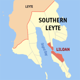 Map of Southern Leyte with Liloan highlighted | |
.svg.png) Liloan Location within the Philippines | |
| Coordinates: 10°09′N 125°08′E / 10.15°N 125.13°ECoordinates: 10°09′N 125°08′E / 10.15°N 125.13°E | |
| Country |
|
| Region | Eastern Visayas (Region VIII) |
| Province | Southern Leyte |
| District | Lone District |
| Barangays | 24 (see Barangays) |
| Government [1] | |
| • Type | Sangguniang Bayan |
| • Mayor | Shirlita Y. Chong |
| • Electorate | 14,729 voters (2016) |
| Area [2] | |
| • Total | 50.30 km2 (19.42 sq mi) |
| Population (2015 census)[3] | |
| • Total | 23,981 |
| • Density | 480/km2 (1,200/sq mi) |
| Time zone | UTC+8 (PST) |
| ZIP code | 6612 |
| PSGC | 086406000 |
| IDD : area code | +63 (0)53 |
| Climate type | Tropical rainforest climate |
| Income class | 4th municipal income class |
| Revenue (₱) | 72,739,365.96 (2016) |
| Native languages |
Boholano dialect Cebuano Tagalog |
Liloan, officially the Municipality of Liloan, is a 4th class municipality in the province of Southern Leyte, Philippines. According to the 2015 census, it has a population of 23,981 people.[3]
Liloan's town center is located at the northern part of Panaon Island which is connected to the mainland of Leyte by a bridge (Wawa Bridge).
"Liloan" is derived from the local term lilo, meaning "whirlpool". Whirlpools can be seen at Panaon Strait, the navigable narrow waterway between the mainland of Leyte and Panaon island.
Barangays
Liloan is politically subdivided into 24 barangays.
- Amaga
- Anilao
- Bahay
- Cagbungalon
- Cali-an
- Fatima
- Caligangan
- Catig/Caritas Village
- Candayuman
- Estela
- Gud-an
- Guintoylan
- Himayangan
- Ilag
- Magaupas
- Malangsa
- Pres. Quezon (Maugoc)
- Molopolo
- Pandan
- Poblacion
- President Roxas (Nailong)
- San Isidro
- San Roque
- Tabugon
Demographics
| Population census of Liloan | ||
|---|---|---|
| Year | Pop. | ±% p.a. |
| 1903 | 4,319 | — |
| 1918 | 11,496 | +6.74% |
| 1939 | 17,386 | +1.99% |
| 1948 | 19,233 | +1.13% |
| 1960 | 12,772 | −3.35% |
| 1970 | 13,882 | +0.84% |
| 1975 | 15,639 | +2.42% |
| 1980 | 16,923 | +1.59% |
| 1990 | 18,383 | +0.83% |
| 1995 | 17,160 | −1.28% |
| 2000 | 19,838 | +3.16% |
| 2007 | 22,203 | +1.57% |
| 2010 | 22,817 | +1.00% |
| 2015 | 23,981 | +0.95% |
| Source: Philippine Statistics Authority [3][4][5][6] | ||
- The upsurge of the population of Brgy. Fatima is due to the relocation of almost all residents of Malangza and Catig because of the frequent threats of landslides.
Places of interest
- Bitoon Beach, 500 meters from the Wawa Bridge
- Molopolo Beach @ Brgy Molopolo
- Tagbak Marine Park (250 meters from Wawa Bridge)
- Our Lady of Mt. Carmel Cross (pilgrim site)
- Duwangan Beach
- Liloan Lighthouse
- Liloan Ferry Terminal
- Pres. Quezon (maugoc) Pook Adventure Park (adventure site)
- Ollie's Wall (Dive Site) @ Gud-an
- Washing Machine Dive @ Wawa channel
References
- ↑ "Municipality". Quezon City, Philippines: Department of the Interior and Local Government. Retrieved 31 May 2013.
- ↑ "Province: Southern Leyte". PSGC Interactive. Quezon City, Philippines: Philippine Statistics Authority. Retrieved 12 November 2016.
- 1 2 3 Census of Population (2015). "Region VIII (Eastern Visayas)". Total Population by Province, City, Municipality and Barangay. PSA. Retrieved 20 June 2016.
- ↑ Census of Population and Housing (2010). "Region VIII (Eastern Visayas)". Total Population by Province, City, Municipality and Barangay. NSO. Retrieved 29 June 2016.
- ↑ Censuses of Population (1903–2007). "Region VIII (Eastern Visayas)". Table 1. Population Enumerated in Various Censuses by Province/Highly Urbanized City: 1903 to 2007. NSO.
- ↑ "Province of Southern Leyte". Municipality Population Data. Local Water Utilities Administration Research Division. Retrieved 17 December 2016.
External links
- Official Website of Liloan
- Philippine Standard Geographic Code
- Philippine Census Information
- Local Governance Performance Management System
Places adjacent to Liloan, Southern Leyte | ||||||||||
|---|---|---|---|---|---|---|---|---|---|---|
| ||||||||||
This article is issued from
Wikipedia.
The text is licensed under Creative Commons - Attribution - Sharealike.
Additional terms may apply for the media files.