Gil Puyat Avenue
| |
|---|---|
| Buendia Avenue | |
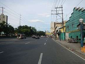 Gil Puyat Avenue looking east from Harrison Avenue towards Leveriza Street, in Pasay. | |
| Route information | |
| Length | 5.4 km (3.4 mi) |
| Component highways | |
| Major junctions | |
| West end | Roxas Boulevard in Pasay |
|
Taft Avenue Osmeña Highway (SLEX) Chino Roces Avenue Ayala Avenue Makati Avenue Paseo de Roxas | |
| East end | Epifanio de los Santos Avenue in Makati |
| Location | |
| Major cities | Makati and Pasay |
| Highway system | |
|
Roads in the Philippines | |
.svg.png)
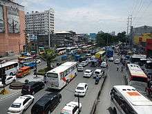
Senator Gil Puyat Avenue (formerly and still known unofficially as Buendia Avenue) is a major arterial thoroughfare which travels east–west through the cities of Makati and Pasay in western Metro Manila, Philippines. It is one of the busiest avenues in Metro Manila linking the Makati Central Business District with the rest of the metropolis. Its western end begins at Roxas Boulevard and continues through San Isidro District, Pasay until intersecting with Taft Avenue. Past the intersection with the elevated Gil Puyat LRT Station, the road runs through Tramo Street and Barangay Palanan in Makati. East of Osmeña Highway, Gil Puyat intersects with the busy streets of the Central Business District before finally reaching its terminus at Epifanio de los Santos Avenue (EDSA).
This 4-12 lane divided avenue takes its name from the Filipino senator who served from 1951-1972, Senator Gil J. Puyat. It was originally named Buendia Avenue after Nicolas Buendia, a Bulacan senator of the 1940s.[1][2] The avenue also has short extensions into Forbes Park in Makati as Buendia Avenue Extension, and into the CCP Complex and Bay City area of Pasay as Jose Diokno Boulevard. Part of Gil Puyat Avenue is designated as a component of Circumferential Road 3 of the Metro Manila Arterial Road System.
Transportation

Gil Puyat Avenue is a major stop on three lines of the Metro Manila Transit System.
- Gil Puyat Station at Taft Avenue served by LRT-1.
- Buendia Station at EDSA served by MRT-3.
- Buendia railway station at Osmeña Highway (SLEX) served by PNR.
- This station is now closed; the area is now served by the Dela Rosa railway station, one block southwards.
Hybrid buses operated by Green Frog Transport Corp. serve the route between Gil Puyat and Kalayaan Avenue.[3] It is also served by regular and air-conditioned jeepneys.
Junctions
Here is a list of junctions and distances (according to the Department of Public Works and Highways).
| City | Barangay | Km[4] | Mi | Destination | Notes |
|---|---|---|---|---|---|
| Pasay | Barangay 76-8-10 boundary | 3.289-4.724 | 2.043-2.934 | Roxas Boulevard | Western terminus |
| Barangays 9-10-23-24 boundary | Harrison Avenue | Turns via U-turn slot only | |||
| Barangays 23-24-37-38 boundary | Leveriza Street | Turns via U-turn slot only | |||
| Barangays 37-38 boundary | A. Luna Street, Donada Street | Turns via U-turn slot only | |||
| Barangays 37-38-47-49 boundary | Taft Avenue | Traffic Light Intersection; No left turn from Gil Puyat southbound | |||
| Barangays 47-48-50-52 | Dominga Street, P. Burgos Street | Turn to Dominga or P. Burgos via U-turn | |||
| Barangays 46-48-50-51 boundary | Tramo Street | U-turn slot. No left turn from Gil Puyat westbound. | |||
| Makati | Barangay Palanan | Emilia Street | Westbound entrance. | ||
| Barangay Palanan | Marconi Street | Southbound entrance. | |||
| Barangay San Isidro | Edison Street | Northbound entrance. | |||
| Barangay San Isidro-Palanan boundary | Bautista Street | Traffic Light Intersection | |||
| Barangay San Isidro-Palanan boundary | Dian Street | Traffic Light Intersection | |||
| Barangay San Isidro-Palanan boundary | Batangas Street, Filmore Street | Traffic Light Intersection | |||
| Barangay San Isidro-Pio del Pilar boundary | Osmeña Highway (formerly South Superhighway) | Traffic Light Intersection | |||
| 1.000 mi = 1.609 km; 1.000 km = 0.621 mi | |||||
In Makati:
- Chino Roces Avenue (also known as Pasong Tamo)
- Ayala Avenue
- Malugay-Tordesillas Streets
- Nicanor Garcia Street (Reposo Street)
- Makati Avenue
- Paseo de Roxas
- Epifanio de los Santos Avenue
Landmarks and neighborhoods
Gil Puyat Avenue travels between the Pasay neighborhoods of Leveriza, San Jose, San Isidro and Santa Clara, and the Makati neighborhoods of Palanan, San Isidro, San Antonio, Pio del Pilar, San Lorenzo, Bel-Air Village and Urdaneta. It is the site of some of the tallest buildings in Metro Manila, such as RCBC Plaza on the junction with Ayala Avenue, and Petron Megaplaza, the city's tallest building from 1998-2000. It also hosts the Pacific Star Building, Grand Soho Makati, The World Centre, One Central Makati, Exportbank Plaza, as well as the headquarters of the Department of Trade and Industry and the Department of Tourism which recently moved from its previous location in Rizal Park after it was converted into the Museum of Natural History.
The stretch of Gil Puyat between Makati Avenue and Paseo de Roxas hosts the headquarters of the Metropolitan Bank and Trust Company and Development Bank of the Philippines on Roxas Triangle. Several educational institutions are also located on the avenue such the Makati campuses of the Mapúa Institute of Technology, Far Eastern University, and Centro Escolar University, and iAcademy. The avenue's other notable landmarks in Makati are the Makati Medical Center, the Makati Central Post Office, One Pacific Place, Burgundy Tower, West of Ayala Tower, Teleperformance Center and SM Cyber Makati.
Gil Puyat Avenue in Pasay is the site of the Manila Adventist College and the Manila Adventist Medical Center. It also hosts the headquarters of the Overseas Workers Welfare Administration, Andres Bonifacio Elementary School and Net World Plaza. The intersection with Taft Avenue is the location of several provincial bus terminals, including DLTBCo, JAM Liner and Green Star Express.
References
- ↑ Batas Pambansa Blg. 312
- ↑ Senators Profile - Nicolas Buendia
- ↑ Hybrid buses ply Makati's streets published by the Philippine Star; accessed 2013-10-12.
- ↑ "South Manila". DPWH Road Atlas. Department of Public Works and Highways. Retrieved October 1, 2016.
| Wikimedia Commons has media related to Gil Puyat Avenue. |
| Towers |
|  | ||||
|---|---|---|---|---|---|---|
| Ayala Center | ||||||
| Other landmarks | ||||||
| Education | ||||||
| Transportation |
| |||||
Italics denote buildings under construction or planned. | ||||||
| National primary roads |
| |||||||
|---|---|---|---|---|---|---|---|---|
| National secondary roads |
| |||||||
See also: Philippine expressway network | ||||||||
Coordinates: 14°33′31″N 121°0′35″E / 14.55861°N 121.00972°E