Samson Road
| |
|---|---|
| Circumferential Road 4 | |
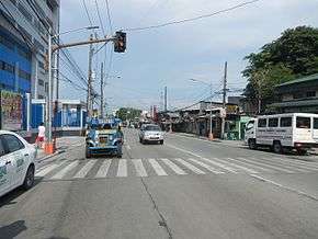 Samson Road, looking east from New Abbey Road near the University of the East Caloocan | |
| Route information | |
| Length | 2.0 km (1.2 mi) |
| Component highways |
|
| Major junctions | |
| East end | Monumento Roundabout in Grace Park |
| West end | Paterio Aquino Avenue in Tonsuya |
| Highway system | |
|
Roads in the Philippines | |
.svg.png)
Samson Road is a major east–west street in Caloocan, northern Metro Manila, Philippines. The road is a continuation of Epifanio de los Santos Avenue (EDSA), linked to it via the Monumento Roundabout to form a single through route. These roads form part of Circumferential Road 4 (C-4) of the Metro Manila Road Network.
Samson Road is named for Apolonio Samson, a Katipunan barrio lieutenant from Sitio Kangkong, Balintawak, Caloocan (now Quezon City) who fought alongside Andres Bonifacio during the Philippine Revolution.[1][2]
Route
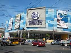
Samson Road, the main road in South Caloocan, officially begins at the Bonifacio Monument Roundabout (Monumento) and ends in Malabon at the junction with Paterio Aquino Avenue. At its eastern terminus, it runs between Araneta Square mall and Puregold (on the northwest corner of Rizal Avenue and Samson Road), and SM Hypermarket (on the southwest corner of MacArthur Highway and Samson) in Monumento. For much of its length, the road is generally commercial, with a mix of high-density residential zones as well as a few schools. A notable site along the road is the University of the East Caloocan (formerly UE Tech) adjacent to SM Center Sangandaan and the Caloocan railway station in Sangandaan. It is also the home of the University of Caloocan City and the Philippine National Railways Hospital (Col. Salvador T. Villa Memorial Hospital). The road ends at C-4 Road, just after crossing Paterio Aquino Avenue in the city's border with Malabon.
References
- ↑ Talambuhay ni Apolonio Samson published by Tagaloglang.com; accessed 2013-11-03.
- ↑ QC: A Saga of Continuing Progress Archived 2015-09-24 at the Wayback Machine. published by Quezon City Public Library; accessed 2013-11-03.
Coordinates: 14°39′26″N 120°58′38″E / 14.65722°N 120.97722°E