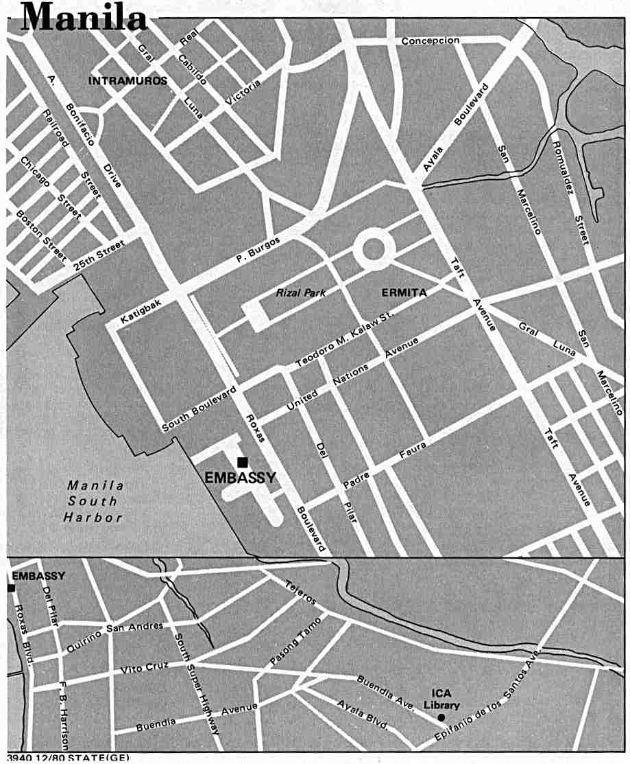
Roxas Boulevard
| |
|---|---|
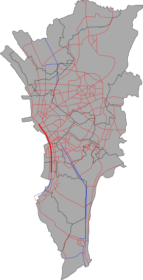 Map of Roxas Boulevard in Metro Manila | |
 Roxas Boulevard along the Manila Bay | |
| Route information | |
| Auxiliary route of AH26 | |
| Maintained by Department of Public Works and Highways[1][2] | |
| Length |
7.6 km (4.7 mi) from Google Earth |
| Existed | 1910s – present |
| Component highways | |
| Restrictions | No trucks, trailers, and buses from Padre Burgos Avenue/Katigbak Parkway to Gil Puyat Avenue. |
| Major junctions | |
| North end | Padre Burgos Avenue in Ermita[3][4] |
| South end |
|
| Location | |
| Major cities | Manila, Pasay, Parañaque |
| Highway system | |
|
Roads in the Philippines | |
_sign.svg.png)
.svg.png)
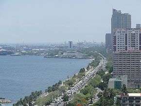
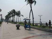
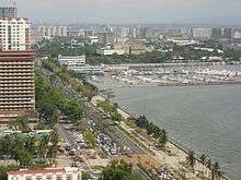
Roxas Boulevard is a popular waterfront promenade in Manila in the Philippines. The boulevard, which runs along the shores of Manila Bay, is well known for its sunsets and stretch of coconut trees. The divided roadway has become a trademark of Philippine tourism, famed for its yacht club, hotels, restaurants, commercial buildings and parks. Originally called Cavite Boulevard,[5] it was renamed Dewey Boulevard in honor of the American Admiral George Dewey, whose forces defeated the Spanish navy in the Battle of Manila Bay in 1898. The boulevard was again renamed to Heiwa Boulevard in late 1941 during Japanese Home Rule and Roxas Boulevard in the 1960s to honor President Manuel Roxas, the fifth president of the Republic of Philippines.
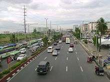
The boulevard is also an eight-lane major arterial road in Metro Manila designated as Radial Road 1 (R-1) of Manila's arterial road network, National Route 61 (N61) and National Route 120 (N120) of the Philippine highway network and a spur of Asian Highway 26 (AH26). The arcing road runs in a north-south direction from Luneta in Manila and ends in Parañaque at the intersection of NAIA Road and the elevated NAIA Expressway.[6] Beyond its southern terminus, starts the Manila-Cavite Expressway, also known as the Coastal Road, or more recently, CAVITEX.
History

City Beautiful movement
The Cavite Boulevard was part of Architect Daniel Burnham's plan for beautifying the city of Manila.[7] At the request of Commissioner William Cameron Forbes, Burnham visited the country in 1905 at the height of the City Beautiful movement, a trend in the early 1900s in America for making cities beautiful along scientific lines, for the future urban development of Manila and Baguio City.[8]
Original concept
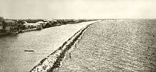
According to Burnham's original concept of the Cavite Boulevard, the bayfront from the Luneta southward should be a continuous parkway, extending in the course of time all the way to the Cavite Navy Yard about 20 miles (32 km) away. This boulevard, about 250 ft (76 m) in width, with roadways, tramways, bridle path, rich plantations, and broad sidewalks, should be available for all classes of people in all sorts of conveyances, and so well shaded with coconut palms, bamboo, and mangoes as to furnish protection from the elements at all times.
In order to make the boulevard presentable and useful as soon as possible, a quick-growing tree like the acacia might be planted, alternating with the trees of slower growth, and be replaced after the latter attain their growth. The boulevard's seaward side should be planted so as to interrupt occasionally the view of the sea and, by thus adding somewhat of mystery, enhance the value of the stretch of ocean and sky. The boulevard would be on reclaimed land to about as far south as the Old Fort San Antonio Abad in Malate, beyond which it strikes the beach and follows the shore line to Cavite. The possible extension of the ocean boulevard along the north shore would naturally depend upon the development of the town in that direction and upon the question of additional harbor works north of the Pasig River.[8]
Route description
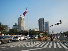
Roxas Boulevard starts at Rizal Park as a physical continuation of Bonifacio Drive. The road passes through many tall buildings, restaurants, banks, monuments, and other establishments. The United States Embassy office can also be seen on this area. On Malate area, the headquarters of Bangko Sentral ng Pilipinas (BSP) and Philippine Navy are located on a district. After the BSP building, the boulevard enters Pasay, passing through the CCP Complex and Star City. It then intersects with Senator Gil Puyat Avenue, where it ascends through the Gil Puyat flyover. It now parallels the Diosdado Macapagal Boulevard. It ascends again to intersect EDSA through the flyover of the same name. A few meters after passing EDSA, it enters Paranaque, continues into a straight route until it ends on an intersection with NAIA Expressway, where the road continues south as Manila-Cavite Expressway (CAVITEX) which is also known as Coastal Road.
Landmarks
.jpg)
Parks
CCP Complex
- Folk Arts Theater
- Manila Film Center
- Tanghalang Pambansa
- Star City amusement park
Convention and trade center
- Philippine International Convention Center (CCP complex)
- World Trade Center Metro Manila (CCP complex)
Government buildings
- Bangko Sentral ng Pilipinas (Central Bank of the Philippines)
- Department of Foreign Affairs
- Department of Finance
- Philippine Navy
- Senate of the Philippines (GSIS Building)
- Office of the Vice President of the Philippines (Coconut Palace)
Foreign embassies
- Embassy of the United States in Manila
- Embassy of Japan in Manila
Museums
- Metropolitan Museum of Manila (Central Bank of the Philippines Complex)
- Museo Pambata (the old Manila Elks Club)
- Bangko Sentral ng Pilipinas Money Museum (Central Bank of the Philippines Complex)
- Asian Institute of Maritime Studies Museo Maritimo (AIMS Maritime College Campus)
Hotels
- Hotel Jen Manila
- Manila Hotel
- Diamond Hotel
- Sofitel Philippine Plaza Hotel (CCP complex)
- Heritage Hotel Manila
- Midas Hotel & Casino (formerly the Hyatt Regency Manila)
- Admiral Hotel
- Bayview Park Hotel Manila
- City of Dreams Manila
Yacht club
Educational Institutions
- Asian Institute of Maritime Studies
- Manila Tytana Colleges formerly Manila Doctors College - Educational Arm of Metrobank Group
- San Juan de Dios Educational Foundation, Inc.- College
Intersections
Intersections are numbered by kilometer post, with Rizal Park in Manila designated as kilometre 0. The kilometer count is discontinuous.
| Province | City/Municipality | km[1][2] | mi | Destinations | Notes |
|---|---|---|---|---|---|
| Pasay | 7.444 | 4.625 | Southern terminus. | ||
| 6.546 | 4.067 | Aseana Avenue | |||
| 6.348 | 3.944 | Airport Road | |||
| 6.099 | 3.790 | Bradco Avenue | |||
| 5.811 | 3.611 | Redemptorist Road | |||
| South end of EDSA Flyover | |||||
| 5.256 | 3.266 | ||||
| North end of EDSA Flyover | |||||
| 4.191 | 2.604 | Arnaiz Avenue | Northbound access only. Southbound access via U-turn slot under EDSA Flyover | ||
| South end of Gil Puyat Flyover | |||||
| 4.469 | 2.777 | ||||
| North end of Gil Puyat Flyover | |||||
| Manila | 2.581 | 1.604 | Pablo Ocampo Street | ||
| 2.121 | 1.318 | ||||
| 2.349 | 1.460 | San Andres Street | |||
| Remedios Street | |||||
| 1.062 | 0.660 | Pedro Gil Street | |||
| Padre Faura Street | |||||
| 0.000 | 0.000 | Kilometer zero. (Kilometer count reverses) | |||
| 0.205 | 0.127 | Northern terminus. | |||
| 1.000 mi = 1.609 km; 1.000 km = 0.621 mi | |||||
See also
References
- 1 2 "South Manila". DPWH Road Atlas. Department of Public Works and Highways. Archived from the original on 2015-12-22. Retrieved 2015-12-12.
- 1 2 "Metro Manila 2nd". DPWH Road Atlas. Department of Public Works and Highways.
- ↑ "Manila map". University of Texas at Austin Library. Retrieved on 2011-06-05.
- ↑ "Rizal Park-Manila Map". Google Maps. Retrieved on 2011-06-05.
- ↑ "United States Congressional serial set, Issue 5280 - Act no. 1745, Section 2a", pg. 417. Government Printing Office, Washington.
- ↑ "Intersection of Roxas Blvd. and NAIA Rd". Google Maps. Retrieved on 2011-06-05.
- ↑ (1910). "Report of the Philippine Commission to the Secretary of War", pg.68. Government Printing Office, Washington.
- 1 2 (1907-03). "Far Eastern Review - Details and Description of the Burnham Plans for the Reconstruction of Manila", pg.322. Google Books. Retrieved on 2012-04-13.
External links
| Wikimedia Commons has media related to Roxas Boulevard. |
Coordinates: 14°34′05″N 120°59′00″E / 14.56806°N 120.98333°E