Matnog, Sorsogon
| Matnog | ||
|---|---|---|
| Municipality | ||
| Municipality of Matnog | ||
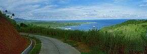 Skyline of Matnog | ||
| ||
| Nickname(s): Gateway of Luzon | ||
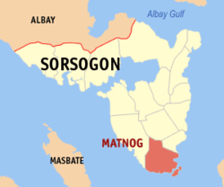 Map of Sorsogon with Matnog highlighted | ||
.svg.png) Matnog Location within the Philippines | ||
| Coordinates: 12°35′N 124°05′E / 12.58°N 124.08°ECoordinates: 12°35′N 124°05′E / 12.58°N 124.08°E | ||
| Country |
| |
| Region | Bicol Region (Region V) | |
| Province | Sorsogon | |
| District | 2nd district of Sorsogon | |
| Founded | May 17, 1800 | |
| Barangays | 40 (see Barangays) | |
| Government [1] | ||
| • Type | Sangguniang Bayan | |
| • Mayor | Claudith Morata-So | |
| • Electorate | 23,270 voters (2016) | |
| Area [2] | ||
| • Total | 162.40 km2 (62.70 sq mi) | |
| Population (2015 census)[3] | ||
| • Total | 41,101 | |
| • Density | 250/km2 (660/sq mi) | |
| Time zone | UTC+8 (PST) | |
| ZIP code | 4708 | |
| PSGC | 056212000 | |
| IDD : area code | +63 (0)56 | |
| Climate type | Tropical rainforest climate | |
| Income class | 3rd municipal income class | |
| Revenue (₱) | 111,439,866.35 (2016) | |
| Native languages |
Sorsoganon language Tagalog | |
| Website |
www | |

Matnog, officially the Municipality of Matnog, is a 3rd class municipality in the province of Sorsogon, Philippines. According to the 2015 census, it has a population of 41,101 people.[3]
Local elders say that the name Matnog comes from the word "matonog" (very audible) - that describes to the loud sound of the waves. The native people of Matnog are the Agta, Tabangon, and Cimaron Tribe. The site of one of the busiest seaports in the Philippines, it is the jump off point to the southern Philippines and vice versa.
Barangays
Matnog is politically subdivided into 40 barangays.
- Balocawe
- Banogao
- Banuangdaan
- Bariis
- Bolo
- Bon-Ot Big
- Bon-Ot Small
- Cabagahan
- Calayuan
- Calintaan
- Caloocan (Poblacion)
- Calpi
- Camachiles (Poblacion)
- Camcaman (Poblacion)
- Coron-coron
- Culasi
- Gadgaron
- Genablan Occidental
- Genablan Oriental
- Hidhid
- Laboy
- Lajong
- Mambajog
- Manjumlad
- Manurabi
- Naburacan
- Paghuliran
- Pangi
- Pawa
- Poropandan
- Santa Isabel
- Sinalmacan
- Sinang-Atan
- Sinebaran
- Sisigon
- Sua
- Sulangan
- Tablac (Poblacion)
- Tabunan (Poblacion)
- Tugas
Demographics
| Population census of Matnog | ||
|---|---|---|
| Year | Pop. | ±% p.a. |
| 1903 | 2,457 | — |
| 1918 | 4,437 | +4.02% |
| 1939 | 10,119 | +4.00% |
| 1948 | 12,036 | +1.95% |
| 1960 | 15,570 | +2.17% |
| 1970 | 20,330 | +2.70% |
| 1975 | 20,680 | +0.34% |
| 1980 | 24,193 | +3.19% |
| 1990 | 25,957 | +0.71% |
| 1995 | 29,309 | +2.30% |
| 2000 | 32,712 | +2.38% |
| 2007 | 34,517 | +0.74% |
| 2010 | 37,641 | +3.20% |
| 2015 | 41,101 | +1.69% |
| Source: Philippine Statistics Authority[3][4][5][6] | ||
Model Ecological City
A consortium of Filipino and Japanese investors are leading the establishment of an Ecological Model City or Eco City in this town. The "Eco City" is a 50-hectare development zone which will feature eco-friendly industrial and manufacturing plants. It will include an international airport to be built inside the zone.[7]
Transportation
Transportation includes buses going to and from Metro Manila and Bulan and ferries going to and from Allen, Northern Samar.[8]
References
- ↑ "Municipality". Quezon City, Philippines: Department of the Interior and Local Government. Retrieved 31 May 2013.
- ↑ "Province: Sorsogon". PSGC Interactive. Quezon City, Philippines: Philippine Statistics Authority. Retrieved 12 November 2016.
- 1 2 3 Census of Population (2015). "Region V (Bicol Region)". Total Population by Province, City, Municipality and Barangay. PSA. Retrieved 20 June 2016.
- ↑ Census of Population and Housing (2010). "Region V (Bicol Region)". Total Population by Province, City, Municipality and Barangay. NSO. Retrieved 29 June 2016.
- ↑ Censuses of Population (1903–2007). "Region V (Bicol Region)". Table 1. Population Enumerated in Various Censuses by Province/Highly Urbanized City: 1903 to 2007. NSO.
- ↑ "Province of Sorsogon". Municipality Population Data. Local Water Utilities Administration Research Division. Retrieved 17 December 2016.
- ↑ http://www.mb.com.ph/articles/210730/japanese-traders-build-100million-model-city
- ↑ Bloom, Greg (September 15, 2010). Philippines. Lonely Planet. p. 202. ISBN 9781742203706.
External links
| Wikimedia Commons has media related to Matnog, Sorsogon. |
- Philippine Standard Geographic Code
- Philippine Census Information
- Local Governance Performance Management System
- Matnog, Sorsogon LGU Profile
Places adjacent to Matnog, Sorsogon | |
|---|---|