Sumulong Highway
| |
|---|---|
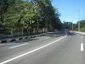 The highway in Mambugan, Antipolo | |
| Route information | |
| Component highways |
|
| Major junctions | |
| From | A. Bonifacio Avenue and J.P. Rizal Street in Marikina |
| |
| To | L. Sumulong Memorial Road a.k.a. Antipolo Circumferential Road (N600) in Antipolo |
| Highway system | |
|
Roads in the Philippines | |
.svg.png)
Sumulong Highway, constructed in 1960,[1] is the highway in the Philippines that connects Marikina[2] with Antipolo and the municipalities of Teresa and Morong in the province of Rizal. It was named after Don Juan Sumulong, a former President of the Democrata Party.
Near the boundary of Antipolo with Marikina the highway meets the Marikina-Infanta Highway,[3] the highway that connects Metro Manila with the northern towns of Infanta and General Nakar in the province of Quezon. It is sometimes referred in media as the "killer highway" [4] due to the number of accidents that have taken place on it.[5]
References
- ↑ http://www.antipolocity.com/history.htm
- ↑ "Caught up in traffic blog". Sumulong highway - Marikia to Masinag. Wordpress. Retrieved 24 October 2013.
|first1=missing|last1=in Authors list (help) - ↑ Suazo, Joselito. "MARCOS HIGHWAY To SUMULONG HIGHWAY Antipolo city - A 15 minute journey". You Tube. Retrieved 24 October 2013.
- ↑ Calleja, Nina (1 July 2012). "12 hurt as jeepney crashes into cars, garage in Antipolo's 'killer highway'". Philippine Inquirer. Retrieved 24 October 2013.
- ↑ Magunnay, Kristine (23 December 2011). "Tragedy in Antipolo city". Philippine Inquirer. Retrieved 24 October 2013.
| Expressways |
| ||||||
|---|---|---|---|---|---|---|---|
| National Roads |
| ||||||
This article is issued from
Wikipedia.
The text is licensed under Creative Commons - Attribution - Sharealike.
Additional terms may apply for the media files.