South Luzon Expressway
| |
|---|---|
|
South Superhighway President Sergio Osmeña Sr. Highway[1] Dr. Jose P. Rizal Highway[2] | |
 | |
| Route information | |
| Part of AH26 | |
| Maintained by Department of Public Works and Highways and Metropolitan Manila Development Authority (Osmeña Highway/South Superhighway), Skyway Operations and Maintenance Corporation (Metro Manila Skyway), and Manila Toll Expressway Systems, Inc. (South Luzon Tollway, SLEX Main, ACTEX) | |
| Length | 51 km (32 mi) |
| Component highways |
|
| Restrictions |
|
| Major junctions | |
| North end |
|
| |
| South end |
|
| Location | |
| Provinces | Metro Manila, Laguna, Cavite, Batangas |
| Major cities | Manila, Makati, Pasay, Taguig, Parañaque, Muntinlupa, San Pedro, Biñan, Santa Rosa, Cabuyao, Calamba |
| Towns | Carmona, Santo Tomas |
| Highway system | |
|
Roads in the Philippines | |
.svg.png)
.svg.png)
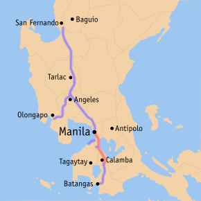
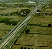
The South Luzon Expressway (SLE or SLEx), formerly known as the South Superhighway (SSH), Manila South Diversion Road (MSDR), and Manila South Expressway (MSEX), is a network of two expressways that connects Metro Manila to the provinces of the Calabarzon region in the Philippines. The first expressway is the Skyway, operated jointly by the Skyway Operation and Management Corporation (SomCo) and Citra Metro Manila Tollways Corporation (CMMTC). The second expressway, the South Luzon Tollway or Alabang–Calamba–Santo Tomas Expressway (ACTEX), is jointly operated by the South Luzon Tollway Corporation, a joint venture of the Philippine National Construction Corporation and the San Miguel Corporation-backed Citra group of Indonesia (the group where MTD Capital Berhad, the original partner, sold their shares) via the Manila Toll Expressway Systems, Inc. (MATES).
The expressway is a component of Expressway Route 2 (E2) of the Philippine expressway network and Radial Road 3 (R-3) of Manila's arterial road network. It starts in Manila's Paco District at Quirino Avenue and passes through the following cities and municipalities: Makati, Pasay, Parañaque, Taguig and Muntinlupa in Metro Manila, San Pedro and Biñan in Laguna, Carmona in Cavite, then transverses again to Biñan, Santa Rosa, Cabuyao and Calamba in Laguna and ends in Santo Tomas in Batangas. The segment of the expressway from Magallanes Interchange to Calamba Exit (Exit 50) is part of National Route 1 (Asian Highway 26).
In 2006, the South Luzon Tollway segment underwent rehabilitation through the SLEX Upgrading and Rehabilitation Project, which rehabilitates and expands the Alabang Viaduct as well as the road from Alabang to Calamba, and eventually connect the expressway to the Southern Tagalog Arterial Road in Santo Tomas, Batangas.
Route description
Since 2010, the South Luzon Expressway network cuts southwards from Manila up to the provinces of Laguna, Cavite, and Batangas. Future plans call for the extension of the expressway to Quezon. It is composed of the Metro Manila Skyway System and the South Luzon Tollway/Alabang-Calamba-Santo Tomas Expressway, which contains portions of the Pres. Sergio Osmeña Sr. Highway and Dr. Jose P. Rizal Highway. A short portion of the expressway between Magallanes and Nichols is built at-grade. Various high voltage overhead power lines, most notably the Paco-Muntinlupa segment of Sucat-Araneta-Balintawak and Bay-Biñan transmission lines of National Grid Corporation of the Philippines (NGCP) from Quirino Avenue to Maricaban Creek, Carmona to Calamba exits, and near Purok 2 Makiling overpass to Siam-Siam bridge, utilize a significant portion of the expressway route as the densely populated areas hinder acquisition of dedicated right of way.
Pres. Sergio Osmeña Sr. Highway/South Superhighway
| |
|---|---|
| Location | Manila – Makati |
The Pres. Sergio Osmeña Sr. Highway segment starts from an intersection at Quirino Avenue in Paco, Manila and goes straight up to Alabang in Muntinlupa. The part of Osmeña Highway which passes through Manila, Makati, Pasay and Taguig is a toll-free highway before reaching the Nichols Toll Plaza from which the tolled expressway begins. Heading southward, the expressway has exits in C-5 Road in Taguig, the Merville Subdivision and Bicutan in Parañaque, and Sucat, Alabang, and Filinvest in Muntinlupa. This segment was formerly known as South Superhighway before Republic Act 6760 was passed, naming it after former President Sergio Osmeña.[1] Most of Osmeña Highway parallels the PNR Metro South Commuter Line.
Osmeña Highway starts at the traffic light with Quirino Avenue. It then crosses San Andres Street, Ocampo (Vito Cruz) Street, and Zobel Roxas Street. The highway climbs over to pass above Gil Puyat Avenue through the Buendia Flyover, with service roads to serve that avenue and several side streets. The Skyway starts on the ramps past Buendia Flyover. Osmeña Highway crosses over Arnaiz Avenue, and soon crosses over EDSA at the Magallanes Interchange. The concurrency with the Pan-Philippine Highway starts at that interchange. Past Magallanes Interchange, the highway features 5 lanes, with 1 lane designated as motorcycle lanes until it comes near Nichols Interchange, where the toll road starts. Osmeña Highway becomes a toll road past the Sales Interchange, with motorcycles below 400cc prohibited to use the tolled expressway.
The part of Osmeña Highway north of Magallanes Interchange is maintained by the Department of Public Works and Highways (DPWH) through the South Manila District Engineering Office, and the portion south is maintained by the Skyway Operations and Management Company. The Metropolitan Manila Development Authority (MMDA) has jurisdiction also of both segments, and maintains motorcycle lanes up to Nichols.
Skyway At-Grade (Nichols—Alabang)
| |
|---|---|
| Location | Makati – Muntinlupa |
_sign.svg.png)
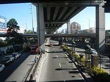
From Nichols, Past the Sales Interchange, Osmeña Highway becomes the tolled At-Grade Skyway System. The expressway includes two service roads until Alabang Exit. The PNR Metro South Commuter Line runs between the At-Grade and Elevated Skyway segments until it passes over C-5 Exit. The expressway and its service roads run through the Pasay-Taguig boundary until it reaches C-5 Exit. Past C-5 Exit, the elevated segment runs over the at-grade segment up to Alabang. The Skyway system slightly curves and passes over Bicutan, running as a straight route with the Elevated Skyway segment above until it reaches Alabang Exit and Alabang Viaduct. The expressways mostly runs through the Parañaque-Taguig boundary until it comes near Sucat, where it crosses Dr. Santos Avenue. The Skyway system enters Muntinlupa, passing over barangays Sucat, Buli, and Cupang, before approaching Alabang. The elevated Skyway soon leaves, curves westward, and descends toward Alabang-Zapote Road. Alabang Exit is the terminus of the expressway from 1969 to 1976, before the Alabang Viaduct was built and extended until Calamba Exit. It is also the site of the former Alabang Toll Barrier prior to the division of the entire SLEX into two concessions namely the Skyway System and SLTC-SLEX (formerly PNCC-SLEX). It climbs over the Maharlika Highway (National Road or Manila South Road) through the Alabang Viaduct, before it descends and becomes the Alabang-Calamba-Santo Tomas Expressway (ACTEx) or SLEX Main.
Dr. Jose P. Rizal Highway
From Kilometer 28.387 at San Pedro, Laguna southwards,[2] the Dr. Jose P. Rizal Highway segment runs through the province of Laguna, as well as a segment of Carmona at Cavite province before continuing back to Laguna from Biñan towards the exit at Calamba through the Maharlika Highway. The highway was also part of the Osmeña Highway until 1992 when R.A. 6760 was amended, which named the segment after the Philippines' national hero, Dr. Jose Rizal.[2] The road starting from Alabang Viaduct in Muntinlupa up to Santo Tomas, Batangas forms the South Luzon Tollway, handled by the South Luzon Tollway Corporation, a joint venture of the Philippine National Construction Corporation and the SMC-backed Citra group of Indonesia.[3]
SLEX Main, Alabang-Calamba-Santo Tomas Expressway/South Luzon Tollway
| |
|---|---|
| Location | Muntinlupa – Santo Tomas, Batangas |
Called as SLEX Main, South Luzon Tollway (SLT), or ACTEx as the alternate name for the part of the R-3 held by South Luzon Tollway Corporation. The ACTEx name refers to the segment of the two SLEX concessions from Alabang Exit in Muntinlupa up to Santo Tomas Exit in Santo Tomas, Batangas.
_-_Carmona_(Carmona%2C_Cavite%3B_2017-03-16).jpg)
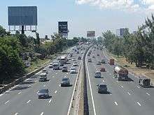
SLEX Main/ACTEX start past Filinvest Exit (Exit 23), with 2 to 4 lanes per direction and mostly paralleling the four-lane Maharlika Highway (National Highway, National Road or officially Manila South Road/MSR) over Muntinlupa and northwestern Laguna.[4] The road slightly curves over barangays Bayanan and Putatan on Muntinlupa. The expressway's first service area, Tollway Plaza, having a Shell gas station and several restaurants such as Jollibee, KFC, Greenwich, Burger King, and others, is also located on this segment. Past that service area, South Luzon Expressway mostly follows a straight course, passing the interchange serving the newly opened Muntinlupa–Cavite Expressway, the Maharlika Highway, and barangays Poblacion and Tunasan in Muntinlupa.
It soon enters Laguna at San Pedro, continuing as a straight roadway lined with billboards and passing through the city's residential and industrial areas before curving and ascending past the Petron and Caltex service areas to clear Pacita Avenue and the disused spur of the PNR South Main Line. South Luzon Expressway soon enters Biñan, passing near Southwoods, Barangay San Francisco (Halang), and Splash Island, before entering Carmona, Cavite. It passes through Carmona in about one kilometer, with an exit to serve the town proper, before re-entering Biñan at Santo Tomas Bridge. The first route marker for AH26 is found on this segment. Returning to Binan, the road runs straight over Barangay Santo Tomas (Calabuso), and enters Barangay Mamplasan, with an exit to serve Laguna International Industrial Park, and several residential communities such as Brentville and Jubilation. A Caltex service is found on the southbound expressway over Mamplasan. It soon enters Santa Rosa, Laguna on a straight route, mostly lined with tress. It intersects Santa Rosa-Tagaytay Road to Santa Rosa city proper and Tagaytay through a partial cloverleaf interchange. South Luzon Expressway reduces into 3 lanes, having guard rails as the median divider. The road passes near Enchanted Kingdom and ETON City, which is within the limits of barangay Don Jose, Santa Rosa, Laguna. A Total service area lies beside the northbound lanes of the expressway. South Luzon Expressway enters Cabuyao, passing near Malayan Colleges Laguna (formerly the location of the warehouses owned by the defunct Uniwide Sales Inc.) and Santa Elena Golf and Country Club. It crosses the San Cristobal River and enters Calamba, being on a straight route until Batangas/Calamba Exit. The road approaches the Calamba toll plaza, widening to 18 lanes (including the lanes on the second southbound toll plaza and the northbound lanes), before returning to 3 lanes per direction. It passes through barangays Mayapa, Batino and Prinza before approaching Batangas/Calamba Exit. At Batangas Exit (exit 50), AH26 leaves the expressway and follows again the Maharlika Highway/Manila South Road. Calamba Exit was the former terminus of the South Luzon Expressway from 1976 to 2010, when the expressway is extended to connect with STAR Tollway and bypass the congested Pan-Philippine Highway/Maharlika Highway over Turbina.

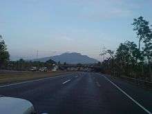
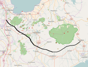
Past Calamba Exit, the expressway narrows to 2 lanes per direction, with no exits. South Luzon Expressway, also called the Alabang-Calamba-Santo Tomas Expressway, follows a curved route paralleling the Pan-Philippine Highway (Maharlika Highway or Manila South Road) from Calamba to Santo Tomas, Batangas. It approaches the Ayala Greenfield toll plaza, continues over barangay Saimsim, and then enters Batangas on Siam-siam Bridge. A few meters after it is the location where a future Toll Road 4 will be located. The expressway curves before it ends at kilometer 57.2, continuing toward Batangas City as the STAR Tollway. However, the kilometer count of the next expressway after the Santo Tomas exit instead starts at kilometer 60.
History
South Luzon Expressway was originally built during the Marcos Era as South Diversion Road or South Superhighway as newer roads used to travel from and to Manila.[5] South Superhighway was referred to as the Manila to Alabang segments that started in 1967 and was completed on December 16, 1969.
In 1976, the expressway was extended by another 29 kilometers (18 mi) from Alabang up to Calamba, Laguna. The project includes the 850-meter (0.53 mi) long viaduct which crosses over Alabang and is called Alabang Viaduct. This later on became the boundary when the PNCC decided to split SLEX into two concessions which renamed the Nichols to Alabang segment as the South Metro Manila Skyway System while the Alabang to Santo Tomas segment retained the South Luzon Expressway concession branding.[6]
Rehabilitation and opening of connection with STAR Tollway
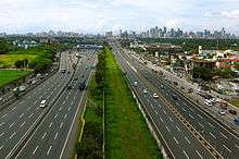
Prior to rehabilitation, the South Luzon Expressway was mostly an expressway with a grass median, and 2 lanes per direction from Alabang to Calamba. Rehabilitation work started in 2006, with heavy traffic brought by construction work. Alabang Viaduct is widened to 4 lanes, and the construction of Skyway Stage 2 caused traffic on the Nichols-Alabang segment. Rehabilitation work was finished in 2009, and the Alabang-Calamba segment was expanded to 3 to 4 lanes.
On 2010, an extension of the expressway, named Alabang-Calamba-Santo Tomas Expressway or ACTEx was opened, eventually connecting South Luzon Expressway to the STAR Tollway.
Future
Toll Road 4 (Santo Tomas-Lucena)
| SLEX Toll Road 4 | |
|---|---|
 Proposed route of SLEX Toll Road 4 from Santo Tomas to Tayabas | |
| Route information | |
| Length | 61 km (38 mi) |
| Major junctions | |
| From | South Luzon Expressway at Santo Tomas, Batangas |
| |
| To | Tayabas, Quezon |
| Location | |
| Major cities | |
| Towns | |
The Toll Road 4 or TR4 is a 61 km (38 mi) extension of SLEX from Santo Tomas in Batangas to Lucena, or Tayabas in Quezon. Construction is divided into 5 segments. The extension project is implemented by the Toll Regulatory Board and will be operated by the South Luzon Tollway Corporation (SLTC). The extension will decongest the existing national road between Santo Tomas and Lucena and provide a modern alternate route for travellers from Quezon and Bicol Region. Right of way for the expressway is acquired for the first three segments between Santo Tomas and Tiaong, and ongoing for the remainder between Tiaong, Candelaria and Tayabas. Right of way acquisition is ongoing as of 2018, with notices sent to affected landowners in Santo Tomas and Alaminos.[7] The future expressway will start near the Ayala Greenfield toll plaza in Calamba in Calamba rather than in Santo Tomas.
If completed, the extension will have these exits:
| Province | City/Municipality | km | mi | Exit | Name | Destinations | Notes |
|---|---|---|---|---|---|---|---|
| Laguna | Calamba | 55 | 34 | Santo Tomas | Connection with the existing route of SLEX. Interchange type not yet known. | ||
| No major junctions | |||||||
| Laguna | Alaminos | 66 | 41 | Makban | |||
| San Pablo | 77 | 48 | San Pablo | Connection via 3 kilometres (1.9 mi) access road. | |||
| Quezon | Tiaong | 85 | 53 | Tiaong | |||
| Candelaria | 100 | 62 | Candelaria | ||||
| Candelaria Spur road toll plaza (electronic toll collection, cash payments) | |||||||
| Sariaya | Sariaya | ||||||
| Tayabas | 111 | 69 | Tayabas | Eastern terminus. | |||
1.000 mi = 1.609 km; 1.000 km = 0.621 mi
| |||||||
Skyway Stage 3 / NLEx-SLEx Connector Road (Segment 11)
Two proposals for connecting the SLEx with the North Luzon Expressway (NLEx) have been under consideration by the government since 2010.[8] According to then-DPWH Secretary Rogelio Singson both proposals would be pushed through, as the proposals can co-exist as the projects service two different corridors of the metro.[9] On May 23, 2012, both companies presented their proposals to then-President Benigno S. Aquino III. The administration then announced through then-Communications Secretary Ricky Carandang that they hoped both companies could be given formal awarding and final approval by the end of the year, so that they could begin "by the end of this year or early next year.",[8] Construction began in 2018.
CMMTC Proposal/Skyway Stage 3
Dubbed as the "Skyway Stage 3", the Department of Public Works and Highways (DPWH) had received an unsolicited proposal for the construction of the elevated toll road Skyway’s extension from San Miguel Corp. backed Citra Metro Manila Tollways Corp. (CMMTC) which according to their proposal will run from Bicutan, Taguig to Balintawak, Quezon City.[9]
The DPWH plans to include the project in its PPP thrust and plans to subject the proposal to a Swiss Challenge, Public Works Undersecretary Romeo S. Momo said in a telephone interview on Friday. A Swiss challenge requires a government agency which has received an unsolicited bid for a project to publish the bid and invite third parties to match or exceed it.[9]
As of November 29, 2013, the ₱26.6 billion "Skyway Stage 3 Project" is undergoing a review of the detailed engineering design by the IC.[10]
Construction began in the First Quarter of 2015.
MPTDC Proposal/NLEX-SLEX Connector Road (Segment 11)
Meanwhile, a year before the CMMTC proposal was unveiled NLEX concessionaire subsidiary Metro Pacific Tollway Development Corporation (MPTDC) through its Manila North Tollways Corporation (MNTC) submitted their proposal which is dubbed as "Segment 11 or the NLEx-SLEx Connector Road" in the NLEx Phase 2 project which involves the construction of a 13.24 kilometer Elevated Expressway from Buendia (Skyway Stage 1) to the C-3 Road which will connect to the NLEx via Segment 10 of the NLEx Phase 2 project in which most of the elevated roadway will be located above the Philippine National Railways Right-Of-Way.[9]
As of November 29, 2013, the "NLEx-SLEx Connector Road" project worth an estimated ₱21.2 billion was approved as a Joint Venture Project under Presidential Decree 1894 according to the PPP Center[11] of the Philippines.
SLEX Extension to Matnog, Sorsogon (Toll Road 5/Quezon-Bicol Expressway)
Dubbed as Toll Road 5/Quezon-Bicol Expressway, the South Luzon Expressway will be extended to Matnog from Lucena, Quezon. The total length of the extension will be 430.1 kilometers. The extension will decongest Andaya Highway and Pan-Philippine Highway, cut travel time from Manila to Naga City by 2–3 hours, and to Matnog by 6 hours and soon be built by Manila Toll Expressway Systems Inc., a company owned 40 percent by Philippine National Construction Corp. The rest is shared equally by the local firm Alloy Manila Expressway Inc. and the SMC-backed Citra Group of Indonesia which bought the shares formerly owned by the MTD Capital Berhad of Malaysia. As of 2015, the extension is discussed by Albay Gov. Joey Salceda, Toll Regulatory Board chairman Edmund Reyes, San Miguel Corporation and Ramon Ang.[12] However on April 27, 2017, San Miguel Holdings Corporation and the Philippine National Construction Corporation under its joint venture to implement the Toll Road 5 as part of the P 554 billion Toll Road Expansion.[13]
Technical specifications
- Name: South Luzon Expressway
- Concession Holder: Citra Metro Manila Tollways Corporation (Manila to Alabang), South Luzon Tollway Corporation (Alabang to Santo Tomas, Batangas)
- Operator: Skyway Operations and Maintenance Corporation (Manila to Alabang), Manila Toll Expressway Systems (Alabang to Santo Tomas, Batangas)
- Length: 60 km (including the extension)
- Concession starting date: PNCC: March 1977, SLTC: August 2006
- Concession ending date: PNCC: March 2007, SLTC: March 2038
- Highway exits: 23
- Lanes: 6 Lanes (3 Lanes each direction) from Paco, Manila to Buendia, Makati. 12 Lanes (3 on both elevated and at-grade per direction) Buendia, Makati to Sucat, Muntinlupa, 10 Lanes (2 on the Elevated and 3 at-grade per direction) Sucat, Muntinlupa to Hillsborough, Muntinlupa. 8 Lanes (4 Lanes each direction) from Hillsborough, Muntinlupa to Santa Rosa, Laguna, and 6 Lanes (3 Lanes each direction) from Santa Rosa, Laguna to Calamba exit. 4 Lanes (2 lanes each direction) from Calamba, Laguna to Santo Tomas, Batangas.
- Toll plazas: 2
- Rest and Service Areas: 8
- Maximum Height Clearance on Underpasses: 4.27 metres (14.0 ft) (Nichols to Filinvest), 4.8 metres (16 ft) (Filinvest-Calamba), 5.1 metres (17 ft) (Calamba to end of expressway at Santo Tomas)
Toll
(2017-05-21).jpg)
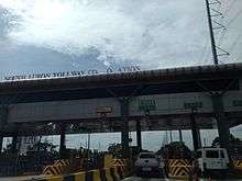
South Luzon Expressway employs closed and barrier toll systems. Upon entry on the expressway, drivers get a paper coupon that is surrendered on the exiting toll plaza. The process was once done using cards with a magnetic strip.
The expressway implements an electronic toll collection (ETC) system, the Autosweep RFID, using RFID technology, and the system formerly used "E-Pass", which uses transponder technology. The ETC system is shared by the Skyway. ETC collection is done on dedicated lanes at the toll plaza, but also done on mixed toll lanes.
The toll rates by vehicle class are as follows:
| Class | Toll |
|---|---|
| Class 1 (Cars, Motorcycles, SUVs, Jeepneys) |
₱3.37/km |
| Class 2 (Buses, Light Trucks) |
₱6.74/km |
| Class 3 (Heavy Trucks) |
₱10.11/km |
Services
Service areas
The South Luzon Expressway has 8 service areas, with 4 on each direction. Most of the service areas occupy large land areas and have restaurants and retail space, with the exception of two service areas near Silangan Exit, which are simply Petron gas stations, both opened in 2016, with no other shops other than a San Mig Food Ave convenience store and car repair services. The service areas also provide ETC reloading for Autosweep RFID users.
| Location | Kilometer | Name | Services | Notes |
|---|---|---|---|---|
| Muntinlupa | 24 | Caltex SLEX Northbound Muntinlupa | Demolished in 2006 after a larger service area in San Pedro opened. | |
| 25 | Shell SLEX Southbound | Burger King, Cinnabon, Greenwich, Hen Lin, Jollibee, KFC, Select, Shell, Starbucks, Subway (formerly Hungry Hippo), Sumoutori | Southbound only. Originally called Tollway Plaza. | |
| San Pedro, Laguna | 28 | Petron SLEX Southbound | Chatime, McDonald's, Petron, San Mig Food Ave, Starbucks, The Coffee Bean and Tea Leaf | Southbound only. |
| Caltex SLEX Northbound | Caltex, Cinnabon, Hen Lin, KFC, McDonald's, 7-Eleven (formerly Star Mart), Starbucks | Replaced Caltex service area in Muntinlupa on 2006. | ||
| Biñan | 35 | Shell SLEX Northbound | BPI ATM, Chowking, Jollibee, Kenny Rogers Roasters, KFC, Levi's, Metrobank ATM, Ministop, Nike Factory Outlet, Pizza Hut, Rai Rai Ken, Shell | Northbound only. Retail outlets added in 2016. |
| 37 | Caltex SLEX Southbound | Addy's Market, Caltex, Kenny Rogers Roasters, McDonald's, North Park, Seattle's Best, Shakey's Pizza, Sisa's Secret, Starbucks, Tokyo Tokyo, Yellow Cab Pizza | Southbound only. | |
| Santa Rosa, Laguna | 40 | Total SLEX Northbound | BPI ATM, Café Bonjour, Chowking, Jollibee, Mang Inasal, Sakon Thai, Total | Northbound only. |
| Calamba, Laguna | 44 | Petron KM 44 SB | Petron, San Mig Food Ave | Southbound only. Former Philippine National Construction Corporation field office. |
| Petron KM 44 NB | Petron, San Mig Food Ave | Northbound only. Former Philippine National Construction Corporation equipment storage. |
Lay-bys
The South Luzon Expressway also has lay-bys, or emergency parking areas where motorists can stop for safety checks on their vehicles and other emergencies.
Exits and intersections
Exits and intersections are numbered by kilometre post, with Rizal Park in Manila designated as kilometre 0. Exits are mostly named and numbered, but exit numbers appear only after Alabang Exit. There is a discrepancy with mileage, with Kilometer 24 being Kilometer 23 rather on the Manila Toll Expressway Systems (MATES) maintained segments of the expressway, although a Kilometer 23 already lies near Cupang, Muntinlupa. From Quirino Avenue to Magallanes Interchange, the expressway is an at-grade secondary national highway named Osmeña Highway, which is a component of National Route 145 (N145) of the Philippine highway network. No tolls are paid on Canlubang, Batino, and Batangas/Calamba exits (exits 47, 49, and 50).
Osmeña Highway/South Superhighway
| Province | City/Municipality | km | mi | Destinations | Notes |
|---|---|---|---|---|---|
| Manila | 4.090 | 2.541 | |||
| 4.650 | 2.889 | San Andres Street | |||
| 5.430 | 3.374 | Pablo Ocampo Street | |||
| 5.490 | 3.411 | Zobel Roxas Street | |||
| Makati | North end of Buendia Flyover | ||||
| South end of Buendia Flyover | |||||
| 6.750 | 4.194 | Southbound entrance and northbound exit of Skyway | |||
| 7.320 | 4.548 | Arnaiz Avenue | Traffic light intersection. No right turns to Arnaiz Avenue from northbound. | ||
| 7.800 | 4.847 | Don Bosco Street | Northbound access only. Southbound access via U-turn slot under Magallanes Interchange. | ||
| 8.710 | 5.412 | Magallanes Interchange | |||
| 1.000 mi = 1.609 km; 1.000 km = 0.621 mi | |||||
Expressway section
| Region | Province | City/Municipality | km | mi | Exit | Name | Destinations | Notes |
|---|---|---|---|---|---|---|---|---|
| Metro Manila | Makati | 7 | 4.3 | Magallanes Interchange. Start of AH26 overlap. | ||||
| 8 | 5.0 | Skyway Magallanes exit. Southbound exit and northbound entrance. | ||||||
| Pasay | 9 | 5.6 | Sales Interchange. Serves Villamor Airbase, NAIA Terminal 3, and Newport City. | |||||
| North end of expressway restrictions. | ||||||||
| Nichols toll plaza (Northbound only. electronic toll collection, cash payments) | ||||||||
| Merville | Merville | Southbound access only. | ||||||
| Nichols toll plaza (Southbound only. electronic toll collection, cash payments) | ||||||||
| 11 | 6.8 | C-5 | C-5, Pasig | Northbound exit and southbound entrance. | ||||
| Parañaque | 13 | 8.1 | Bicutan | Bicutan | Diamond interchange. | |||
| 15 | 9.3 | Skyway | Temporary Skyway San Martin de Porres exit demolished after the completion of Skyway Stage 2. Southbound exit and northbound entrance. | |||||
| Muntinlupa | 18 | 11 | Sucat | Sucat, BF Homes | Diamond interchange. | |||
| 20 | 12 | Skyway SLEX exit. Northbound exit and southbound entrance. | ||||||
| 23 | 14 | Alabang | Filinvest City, South Station, Alabang | Southbound exit and northbound entrance. | ||||
| Manila South Expressway: Alabang toll plaza (1969–1976. demolished) | ||||||||
| Alabang Viaduct | ||||||||
| 23 | 14 | 23 | Filinvest | Filinvest City | Trumpet interchange. South end of Skyway maintenance. North end of Manila Toll Expressway Systems maintenance. | |||
| 23 | 14 | Alabang | Alabang | Northbound exit and southbound entrance. Toll booths of southbound access moved to dedicated booths from the southbound entrance booths of Filinvest Exit. | ||||
| Shell SLEX Southbound (southbound access only) | ||||||||
| 26 | 16 | 26 | Susana Heights/MCX | Susana Heights, MCX, Muntinlupa | Hybrid T and Trumpet interchange. | |||
| Calabarzon | Laguna | San Pedro | 27 | 17 | 27 | San Pedro | San Pedro, La Marea | Southbound exit and entrance only. |
| 29 | 18 | Petron SLEX Southbound service area(southbound access only) | ||||||
| Caltex SLEX Northbound service area (northbound access only) | ||||||||
| Biñan | 32 | 20 | 31 | Southwoods | Southwoods, Biñan | Partial cloverleaf or folded diamond interchange. | ||
| Cavite | Carmona | 34 | 21 | 33 | Carmona | Carmona, Dasmariñas, Biñan | Trumpet interchange. | |
| Santo Tomas Bridge over Carmona River | ||||||||
| Laguna | Biñan | Shell SLEX Northbound (northbound access only) | ||||||
| 36 | 22 | 36 | Greenfield City/Unilab (Mamplasan) | Greenfield City, Unilab, LIIP | Partial cloverleaf or folded diamond interchange. Modification of existing interchange ongoing for future connection with the Cavite–Laguna Expressway. | |||
| Caltex SLEX Southbound service area (southbound access only) | ||||||||
| Santa Rosa | 38 | 24 | 38 | Sta. Rosa | Santa Rosa, Silang, Tagaytay, Enchanted Kingdom | Partial cloverleaf or folded diamond interchange. | ||
| Total SLEX service area (northbound access only) | ||||||||
| 41 | 25 | 41 | Eton City (Malitlit) | Eton City, Asia Brewery, Tagaytay | Double right-in and right-out interchange. | |||
| Cabuyao | 43 | 27 | 43 | Cabuyao | Cabuyao, Santa Elena | Partial cloverleaf or folded diamond interchange. Serves Malayan Colleges Laguna. | ||
| Calamba | Petron KM 44 SB (southbound access only) | |||||||
| Petron KM 44 NB (northbound access only) | ||||||||
| 45 | 28 | 45 | Silangan | Silangan, Carmeltown | Partial cloverleaf or folded diamond interchange. | |||
| Equus City | Entrance still fenced. | |||||||
| Calamba toll plaza (electronic toll collection, cash payments) | ||||||||
| 47 | 29 | 47 | Canlubang (Mayapa) | Canlubang, Mayapa | Partial cloverleaf or folded diamond interchange. | |||
| 49 | 30 | 49 | Batino | Batino, Calamba Premier Industrial Park, Tagaytay Highlands | Southbound exit and entrance only. No toll payment from Canlubang exit. | |||
| 50 | 31 | 50 | Calamba | Calamba, Los Baños, Real, Batangas, Lucena | Half diamond interchange (North half). Partial cloverleaf or folded diamond interchange (South half). South end of AH26 overlap. Former terminus before Santo Tomas extension. | |||
| Ayala Greenfield toll plaza (electronic toll collection, cash payments) | ||||||||
| Batangas | Santo Tomas | 57.2 | 35.5 | Sto. Tomas | Partial cloverleaf or folded diamond interchange. Road continues to Batangas City as STAR Tollway | |||
1.000 mi = 1.609 km; 1.000 km = 0.621 mi
| ||||||||
Toll Road 4
| Province | City/Municipality | km | mi | Exit | Name | Destinations | Notes | |
|---|---|---|---|---|---|---|---|---|
| Batangas | Santo Tomas | 55 | 34 | Connection with the existing route of SLEX. Interchange type not yet known. | ||||
| Laguna | Alaminos | 66 | 41 | Makban | ||||
| San Pablo | 78 | 48 | San Pablo | |||||
| Quezon | Tiaong | 85 | 53 | Tiaong | ||||
| Candelaria | 100 | 62 | Candelaria | |||||
| Candelaria Spur road toll plaza (electronic toll collection, cash payments) | ||||||||
| Sariaya | Sariaya | |||||||
| Tayabas | 111 | 69 | Tayabas | Eastern terminus. | ||||
1.000 mi = 1.609 km; 1.000 km = 0.621 mi
| ||||||||
References
- 1 2 "Republic Act No. 6760". Chan Robles Virtual Law Library. Retrieved 2009-03-01.
- 1 2 3 "Republic Act No. 7620". Chan Robles Virtual Law Library. Retrieved 2009-03-01.
- ↑ Archived 2009-04-03 at the Wayback Machine.
- ↑ Google (28 December 2015). "South Luzon Expressway and Maharlika Highway/Manila South Road" (Map). Google Maps. Google. Retrieved 28 December 2015.
- ↑ Abecilla, Victor (November 3, 2015). "Practical solutions to Metro Manila". The Standard. Retrieved 17 January 2016.
- ↑ https://pncc.ph/projects_slex.htm
- ↑ "SOUTH LUZON EXPRESSWAY (SLEX) TOLL ROAD 4 (TR4)". Department of Public Works an Highways. Retrieved May 13, 2017.
- 1 2 Long Delayed NLEX-SLEX Connector Road Construction to Begin 2013
- 1 2 3 4 Skyway Stage 3/ NLEx-SLEx Connector Road Projects being finalized Archived 2015-06-05 at the Wayback Machine.
- ↑ Philippines' PPP Center Archived 2013-12-07 at the Wayback Machine.
- ↑ PPP Center Archived 2013-12-07 at the Wayback Machine.
- ↑ "I had long discussion with TRB Chairman... – Joey Constant Kindness Salceda". Facebook. 2015-05-08. Retrieved 2015-12-17.
- ↑ "San Miguel sets P554-billion toll road expansion – Krista A. M. Montealegre". BusinessWorld. 2017-04-27. Retrieved 2018-02-06.
External links
| Wikimedia Commons has media related to South Luzon Expressway. |
| Operational | |
|---|---|
| Planned |
|
| Under construction | |
See also: Philippine expressway network | |
| Expressways |
| ||||||
|---|---|---|---|---|---|---|---|
| National highways |
| ||||||
| Provincial roads and other major roads |
| ||||||
| Expressways |
| ||||||||
|---|---|---|---|---|---|---|---|---|---|
| National roads |
| ||||||||
| Arterial Routes |
| ||||||||
| Expressways |
| ||||||
|---|---|---|---|---|---|---|---|
| National highways |
| ||||||