Daraga, Albay
| Daraga | |
|---|---|
| Municipality | |
| Municipality of Daraga | |
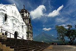 Daraga Church with Mayon Volcano in the background | |
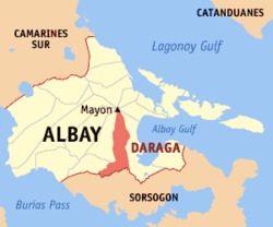 Map of Albay with Daraga highlighted | |
.svg.png) Daraga Location within the Philippines | |
| Coordinates: 13°09′43″N 123°41′38″E / 13.1619°N 123.6939°ECoordinates: 13°09′43″N 123°41′38″E / 13.1619°N 123.6939°E | |
| Country |
|
| Region | Bicol Region (Region V) |
| Province | Albay |
| District | 2nd district |
| Founded | June 12, 1772 |
| Barangays | 54 (see Barangays) |
| Government [1] | |
| • Type | Sangguniang Bayan |
| • Mayor | Carlwyn G. Baldo |
| • Vice Mayor | Victor Perete |
| • Electorate | 66,648 voters (2016) |
| Area [2] | |
| • Total | 118.64 km2 (45.81 sq mi) |
| Population (2015 census)[3] | |
| • Total | 126,595 |
| • Density | 1,100/km2 (2,800/sq mi) |
| Demonym(s) | Daragueño |
| Time zone | UTC+8 (PST) |
| ZIP code | 4501 |
| PSGC | 050503000 |
| IDD : area code | +63 (0)52 |
| Climate type | Tropical rainforest climate |
| Income class | 1st municipal income class |
| Revenue (₱) | 275,468,829.84 (2016) |
| Native languages |
Albay Bikol language Tagalog |
| Website |
www |
Daraga, officially the Municipality of Daraga, (Central Bicolano: Banwaan kan Daraga; Filipino: Bayan ng Daraga), is a 1st class municipality in the province of Albay, Philippines. According to the 2015 census, it has a population of 126,595 people.[3]
The town is home to the landmark Cagsawa Ruins.
History
The word daraga historically referred to a "maiden", and is the modern term for an "unmarried woman" in many of the Bikol languages. The original settlement of Daraga dates back to 12th century, but has changed location repeatedly due to the constant threats posed by Mayon Volcano. The town was previously named Budiao, Cagsawa, and Locsin.
| Year | Event |
|---|---|
| 12th c. | Early settlers were mostly traders. The name Daraga came from a type of tree that was abundant on the hill where a baroque Catholic church now stands. |
| 1578 | Franciscan missionaries arrive, and christen the place Budiao, later renaming it to Cagsawa. |
| 1595 | Cagsawa becomes a visita (satellite mission station) attached to the town of Camalig. |
| 1772 | Governor-General Simón de Anda renames Cagsawa to Salcedo, which is later renamed Daraga. |
| 1814 | Town is destroyed in the deadliest eruption of Mayon Volcano, killing 1,200 people that sought refuge inside the church. |
| 1815 | Government for Daraga is formally organized, with Venancio Espíritu Salomon as Barangay Captain. |
| 1892 | Under the Becerra Law, Daraga becomes a constituent of Legazpi City. |
| 1922 | Daraga regains its autonomy when the Philippine Assembly ordered the partition of Daraga from Albay, composed of Albay and Legazpi City. |
| 1948 | Under Republic Act 306, Daraga is again incorporated into Legazpi as one of its districts.[4] |
| 1954 | Republic Act 993 officially recreates the Municipality of Daraga.[5] |
| 1959 | Daraga renamed to Locsin, through Republic Act No. 2505.[6] |
| 1967 | Republic Act 4994 restores the name Daraga.[7] |
| 1973 | Under Presidential Decree 125, Daraga is again incorporated as part of Legazpi City;[8] implementation of decree was suspended. |
| 1993 | Daraga adjudged the 'cleanest and greenest' municipality in Bicol. |
| 2001 | Mayon Volcano erupts in June, blanketing the town with an inch of ash. |
| 2002 | Municipal government finishes construction of modern supermarket. |
| 2006 | Mudflows from Mayon Volcano, triggered by heavy rains from Typhoon Reming (international name: Durian) buried at least eight villages. More than 20,000 Individuals were evacuated, and thousands lost their homes. |
| 2007 | The National Museum declared the town's 400-year-old Our Lady of the Gate Parish Church a national cultural treasure. |
| 2008 | Daraga experiences economic boom with the opening of several national food chains and the opening of LCC Supermarket. |
| 2010 | The government of Daraga negotiates for the establishment of the Bicol International Airport in the town, with the proposed construction site in Barangay Alobo. |
| 2012 | Daraga holds first ever Cagsawa Festival in February. |
| 2016 | Daraga became the first applicant for cityhood in the 17th congress.[9] |
Geography
Daraga is located at 13°09′43″N 123°41′38″E / 13.1619°N 123.6939°E, in the south-west portion of Albay province, along the Maharlika Highway, making it accessible from Manila, the Visayas, and the other municipalities of eastern Bicol Peninsula. It is roughly "boot-shaped", with the "tall" part ranging 13.05–13.25° north latitude and 123.66–123.73° east longitude and the "wide" part ranging 13.02–13.09° north latitude and 123.56–123.71° east longitude. It is bounded on the north and east by Legazpi City, south by Sorsogon (particularly the municipality of Pilar), and west by Camalig and Jovellar.
According to the Philippine Statistics Authority, the municipality has a land area of 118.64 square kilometres (45.81 sq mi) [2] constituting 4.61% of the 2,575.77-square-kilometre- (994.51 sq mi) total area of Albay. This municipal land area is distributed among the present 16 urban barangays and 42 rural barangays. The urban barangays total 1,500 hectares (3,700 acres) (12.65%) and the rural barangays make up the remaining 10,360 hectares (25,600 acres) (87.35%) of the total municipal land area.[10]
Climate
Daraga has a generally wet climate characterized by a lack of dry season. Maximum rainfall is from November to January, and average monthly rainfall is 223.4 millimetres (8.80 in). Prevailing winds are generally from north-east to south-west. Average temperature is 27.0 °C (80.6 °F).[10]
But the climate change phenomenon has changed the past climate pattern. Dry spells are becoming more pronounced, as it is with the wet season. The phenomenon is felt all over the country as well.
Elevation
67.3% of the total municipal land area has a predominantly low elevation of up to 100 metres (330 ft). The surface terrain is generally characterized by combination of level to nearly level areas, gentle to undulating areas and undulating to rolling areas.
Soil
The different soil types to be found within Daraga are the Mayon Gravelly Sandy Loam, Annam Clay Loam, Gravelly Sandy Loam, Legazpi Fine Sandy Loam (Stoney Phase), Sevilla Clay Loam and Sevilla Clay.
The underlying geology are made up of several types: Alluvium, Shale and Sandstone Limestone and Basalt and Andesite Series. The prevalent geologic type is the Shale and Sandstone Sequence and other equally significant geologic types such as alluvium. Recent Volcanic, Crystalline Limestone and Psyroclastine Limestone are found near the base of Mayon Volcano mostly in the urban barangays.
Minerals available within the municipality of Daraga are non-metallic consisting of Gravel, and Boulders. These minerals are abundant in Barangays Budiao, Busay, Bañadero and Matnog brought down from the slopes of Mayon Volcano during occurrences of volcanic eruptions and rains.
Drainage
The surface drainage pattern of Daraga is largely affected by the water runoff coming from Mayon Volcano coupled with those from other directions. Major river systems which convey and act as natural drainage channels as well as water source include:
- Yawa River in Barangay Cullat, Malobago, Kilicao, Tagas, Binitayan & Bañag which connects to the Albay Gulf in Legazpi City
- Colabos Creek in Bañag, San Roque, Market Area, Sagpon, and Bagumbayan
- Quillarena River in Malabog & Budiao
- Gumacon Creek in Barangay Maroroy, Tagas
- Gulang-Gulang Creek in Barangay Pandan
Barangays
Daraga is politically subdivided into 54 barangays.[11]
| Barangay | Population (2010)[12] | Area (ha)[13] | Class | Barangay head |
|---|---|---|---|---|
| Alcala | 2,755 | 116.18 | Rural | Ester L. Llandeza |
| Alobo | 792 | 160.65 | Rural | Dexter L. Marmol |
| Anislag | 9,445 | 858.50 | Urban | Elmer Lodronio |
| Bagumbayan | 3,254 | 132.54 | Urban | Mark C. Magalona |
| Balinad | 2,230 | 153.74 | Urban | Darren Maceda |
| Bañadero | 1,637 | 204.00 | Rural | Archie Bajamundi |
| Bañag | 2,719 | 27.35 | Urban | Gayzel M. CardiÑO |
| Bascaran | 3,946 | 423.00 | Urban | Julius L. Duran |
| Bigao | 1,015 | 296.08 | Rural | Salvador Miravalles |
| Binitayan | 4,257 | 24.06 | Urban | Celilia A. Arevalo |
| Bongalon | 1,123 | 73.48 | Rural | Ferelyn M. Seva |
| Budiao | 271 | 290.07 | Rural | Jefferson M. Mapula |
| Burgos | 1,122 | 148.67 | Rural | Meriam M. Millena |
| Busay | 1,684 | 213.79 | Rural | Salvyn Mandane |
| Canarom | 501 | 247.36 | Rural | Efren M. Llasos |
| Cullat | 1,460 | 30.78 | Rural | Luis D. Espejo |
| de la Paz | 773 | 73.19 | Rural | Maria L. Marjalino |
| Dinoronan | 608 | 61.07 | Rural | Hirfa M. Espadilla |
| Gabawan | 1,983 | 93.18 | Rural | Roberto C. Obispo |
| Gapo | 1,982 | 389.25 | Rural | Jesus M. Magdaong Jr |
| Ibaugan | 546 | 179.00 | Rural | Raul Ll. Malto |
| Ilawod | 1,987 | 18.42 | Urban | Cecil Mirabete |
| Inarado | 1,694 | 682.22 | Rural | Rommel N. Marticio |
| Kidaco | 1,205 | 116.03 | Rural | Nelson Magallano |
| Kilicao | 3,925 | 379.43 | Urban | Eriberto M. Madrona |
| Kimantong | 1,980 | 20.98 | Urban | Ramon D. Paran Jr. |
| Kinawitan | 405 | 78.46 | Rural | Eduardo N. Lubiano |
| Kiwalo | 1,160 | 57.65 | Rural | Janet L. Lorilla |
| Lacag | 2,321 | 383.86 | Rural | Arthur L. Llabore Sr. |
| Mabini | 581 | 124.83 | Rural | Ranulfo N. Llorera |
| Malabog | 4,099 | 287.46 | Rural | Paulo Montallana |
| Malobago | 492 | 61.56 | Rural | Eduardo Ll. Mazo |
| Maopi | 1,166 | 252.95 | Rural | Alex M.LoteriÑA |
| Market Area | 2,538 | 20.82 | Urban | Wilfredo N. Nayve |
| Maroroy | 5,331 | 73.60 | Urban | Robinson "toto" Lubiano |
| Matnog | 1,680 | 270.15 | Rural | Bonifacio M. Odiver |
| Mayon | 1,759 | 356.70 | Rural | Adoracion Blazo |
| Mi-isi | 1,028 | 518.20 | Rural | Elmer A. Lorica |
| Nabasan | 506 | 552.14 | Rural | Menche A. Llamasares |
| Namantao | 1,538 | 363.07 | Rural | Danilo Llaneta |
| Pandan | 1,683 | 94.32 | Rural | Rosalito Cimanes |
| Peñafrancia | 2,986 | 193.74 | Urban | Jose M. Lobas |
| Sagpon | 5,723 | 29.62 | Urban | Loreto Barajas |
| Salvacion | 3,344 | 551.61 | Rural | Nelson N. Mabini |
| San Rafael | 296 | 32.64 | Rural | Alodea M. Lisay |
| San Ramon | 1,441 | 784.99 | Rural | Aidar L. Llaguno |
| San Roque | 4,308 | 41.97 | Urban | Gina Callada |
| San Vicente Grande | 961 | 346.57 | Rural | Elena M. Vibar |
| San Vicente Pequeño | 320 | 63.67 | Rural | Jesus Oarde |
| Sipi | 3,454 | 38.92 | Urban | Dexter Billy M. Lorica |
| Tabon-Tabon | 2,588 | 207.99 | Rural | Ric M. Rodrigueza |
| Tagas | 6,527 | 100.45 | Urban | Cherry M. Mayor |
| Talahib | 541 | 341.93 | Rural | Nieves M. Jacob |
| Villahermosa | 2,203 | 414.71 | Rural | Eladio L. Rodrigueza |
Demographics
| Population census of Daraga | ||
|---|---|---|
| Year | Pop. | ±% p.a. |
| 1903 | 18,695 | — |
| 1939 | 29,484 | +1.27% |
| 1960 | 41,973 | +1.70% |
| 1970 | 58,335 | +3.34% |
| 1975 | 63,265 | +1.64% |
| 1980 | 73,224 | +2.97% |
| 1990 | 83,928 | +1.37% |
| 1995 | 91,829 | +1.70% |
| 2000 | 101,031 | +2.07% |
| 2007 | 110,625 | +1.26% |
| 2010 | 115,804 | +1.68% |
| 2015 | 126,595 | +1.71% |
| Source: Philippine Statistics Authority[3] [12] [14] [15] | ||
In the 2015 census, Daraga had a population of 126,595.[3] The population density was 1,100 inhabitants per square kilometre (2,800/sq mi).
In 2010, the 2010 municipal population of 115,804 was distributed among the urban and rural Barangays. The urban population was 48.54% while rural population completed the remaining 51.45%. The "built-up density" was 5,659 persons/km2. It had a literacy rate of 96.08% and a municipality growth rate of 1.3%.
In terms of employment and livelihood, farming ranks high at 33.53%, crafts and related workers as well as elementary occupations follow second with 17.71% and 21.89% respectively.
Language
The languages spoken in Daraga include East Miraya (Daragueño), Bicol, Tagalog, and English.
Government
The present (2018) town mayor is Carlwyn "Awin" Baldo.
Economy
Daraga's economy, originally agriculture-based, has rapidly transformed into an emerging urban system, benefiting from the economic opportunities of being located contiguously with the urban center of Legazpi. It draws trade relations with the island province of Masbate through the nearby Port of Pilar.
Daraga will be the site of the future Bicol International Airport which will further boost tourism in the region and will introduce more opportunities especially in this town. Local officials are now considering cityhood in the near future or upon the completion of the said international airport, if that so, Daraga would be the fourth city in Albay.
Daraga has the highest number of business establishments among towns in Albay. As of 2011 it has over 2,300 business establishments registered with the Permits and Licensing Office. The town is a center of handicraft manufacturing with several handicraft factories choosing their location in the municipality.
Education
Elementary
Each barangay in town has an elementary school.
High school
- Anislag National High School
- Anislag National High School - Bascaran HS Extension
- Anislag National High School - San Vicente Grande HS Extension
- Banadero National High School
- Bicol College (BC) - High School Department.
- Daraga National High School
- Immaculate Concepcion College of Albay (ICCA) - High School Department
- Kilicao High School
- Lacag National High School
- Malabog National High School
- Mary's Child Science Oriented School (MCSOS) - High School Department
- United Institute (U.I.) - High School Department
College
- Bicol University – Daraga
- Belen B. Francisco Foundation Inc.
- Bicol College (BC)
- Daraga Community College (DComC)
- Immaculate Concepcion College of Albay (ICCA)
Transportation
Daraga has a total Road Network of about 129.01 kilometres (80.16 mi). This is categorized either as National Roads, Provincial Roads, Municipal Roads and Barangay Roads. These barangay Roads comprised the bulk of the municipality road network system. About 24.97% are concrete paved while the remaining 75.03% remains in Asphalt, Gravel of Earth fill pavement conditions. These are about 25 bridges within the municipality and 66.22% of which are within barangay roads while the other bridges are part of national, provincial of barangay roads.

Tourism
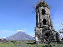
Daraga's existing tourist spots/attractions are the Cagsawa Ruins and Resort and Our Lady of the Gate Parish.
Cagsawa Ruins and Resort is located in Barangay Busay. Its prominent attraction is the Belfry of the Cagsawa Church which submerged in mudflow during the February 2, 1814 Mayon Volcano Eruption which killed 1,200 people.
The Our Lady of the Gate Parish was constructed in 1773 atop Santa Maria Hill in barangay San Roque and is uniquely known for its rich baroque architecture.
References
- ↑ "Municipality". Quezon City, Philippines: Department of the Interior and Local Government. Retrieved 31 May 2013.
- 1 2 "Province: Albay". PSGC Interactive. Quezon City, Philippines: Philippine Statistics Authority. Retrieved 12 November 2016.
- 1 2 3 4 Census of Population (2015). "Region V (Bicol Region)". Total Population by Province, City, Municipality and Barangay. PSA. Retrieved 20 June 2016.
- ↑ "Republic Act No. 306 - An Act Creating the City of Legaspi". Chan Robles Virtual Law Library. 18 June 1948. Archived from the original on 4 March 2016. Retrieved 23 October 2016.
- ↑ "Chan Robles Virtual Law Library". Republic Act No. 993 - An Act Recreating the Municipalities of Legaspi and Daraga in the Province of Albay. 8 June 1954. Archived from the original on 25 September 2013. Retrieved 23 October 2016.
- ↑ "Republic Act No. 2505 - An Act Changing the Name of the Municipality of Daraga, Province of Albay, to Municipality of Locsin". Chan Robles Virtual Law Library. 21 June 1959. Archived from the original on 3 June 2012. Retrieved 23 October 2016.
- ↑ "Republic Act No. 4994 - An Act Changing the Name of the Municipality of Locsin, Province of Albay, to Municipality of Daraga". Chan Robles Virtual Law Library. 17 June 1967. Archived from the original on 26 September 2013. Retrieved 23 October 2016.
- ↑ "Presidential Decree No. 125; Amending Certain Provisions of Republic Act No. 2234, Otherwise Known As the City Charter of Legazpi, and For Other Purposes". Official Gazette of the Republic of the Philippines. Malacañang, Manila, Philippines. 5 February 1973. Archived from the original on 15 October 2016. Retrieved 23 October 2016.
- ↑ Basmayor, MV. "Daraga is first applicant for cityhood in 17th Congress". Bicol Standard. Archived from the original on 20 October 2016. Retrieved 23 October 2016.
- 1 2 "General Information". About the LGU. Municipal Government of Daraga. Archived from the original on 25 April 2012. Retrieved 21 January 2013.
- ↑ "Municipal: Daraga, Albay". PSGC Interactive. Quezon City, Philippines: Philippine Statistics Authority. Retrieved 8 January 2016.
- 1 2 Census of Population and Housing (2010). "Region V (Bicol Region)". Total Population by Province, City, Municipality and Barangay. NSO. Retrieved 29 June 2016.
- ↑ Daraga Municipal Planning and Development Office
- ↑ Censuses of Population (1903–2007). "Region V (Bicol Region)". Table 1. Population Enumerated in Various Censuses by Province/Highly Urbanized City: 1903 to 2007. NSO.
- ↑ "Province of Albay". Municipality Population Data. Local Water Utilities Administration Research Division. Retrieved 17 December 2016.
External links
| Wikimedia Commons has media related to Daraga, Albay. |
Places adjacent to Daraga, Albay | |
|---|---|