Shaw Boulevard
| |
|---|---|
 | |
| Route information | |
| Length | 5.2 km (3.2 mi) |
| Component highways |
|
| Major junctions | |
| West end | Padre Sanchez Bridge in Manila |
|
General Kalentong Street Tomas Claudio Boulevard Acacia Lane F. Martinez Street Luna Mencias Street EDSA San Miguel Avenue Pioneer Street Meralco Avenue | |
| East end | Pasig Boulevard in Pasig |
| Location | |
| Major cities | Mandaluyong, Pasig |
| Highway system | |
|
Roads in the Philippines | |
.svg.png)
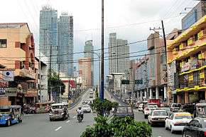
Shaw Boulevard, formerly known as Jose Rizal Boulevard, is a 6-10 lane highway connecting the cities of Mandaluyong and Pasig in the Philippines. The Boulevard is named after William James Shaw, the founder of the Wack Wack Golf and Country Club in Mandaluyong. The road is one of the major thoroughfares of the Ortigas Center in Mandaluyong and Pasig, housing many shopping malls like the Starmall on EDSA-Shaw, The Marketplace and the posh Shangri-La Plaza.[1][2]
It is served by the Shaw Boulevard Station of the MRT-3 along EDSA.
Route description
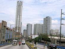
Shaw Boulevard starts at an intersection past Kalentong Street. It follows a slightly curved route over Mandaluyong before crossing EDSA. A flyover carries the road over Shaw Boulevard MRT Station and descends near EDSA Shangri-la. The road becomes a dual carriageway east of EDSA, and soon enters Pasig. Shaw Boulevard extends to C-5 as Pasig Boulevard.
Schools
Shopping Centers
- Starmall
- Ortigas Center
- Shangri-La Plaza
- Puregold Main Branch
- Marketplace
- Crossings Department Store
- SM Cherry
- S&R Membership Shopping
Offices
- World Corporate Center
- Acquire BPO
- E-Telecare Global Solutions CC7 Shaw Site
- ICT
- NetCrossing 2
- Solar Entertainment Corporation
- Nine Media Corporation
- CNN Philippines
Intersections
| Province | City/Municipality | km | mi | Destinations | Notes |
|---|---|---|---|---|---|
| Mandaluyong | Western terminus. Road continues to Manila as P. Sanchez Street. | ||||
| Haig Street | Westbound only. | ||||
| General Kalentong Street | Traffic light intersection. Santa Ana district to the south, San Juan to the north. | ||||
| J. Tiosejo Street | One-way road. | ||||
| F. Bernardo Street | One-way road. | ||||
| E. Magalona Street, V. Fabella Street | One-way roads. | ||||
| A.V. Fabella Street | |||||
| Lawson Street | |||||
| San Clemente Street | |||||
| J.B. Vargas Street | |||||
| E. Jacinto Street | |||||
| Pinagtipunan Street | |||||
| J. Luna Street | |||||
| 29 de Agosto Street | |||||
| L. Gonzales Street, M. Yulo Street | |||||
| L. Cruz Street | |||||
| Araullo Street | Access to San Juan. | ||||
| R. Vicencio Street, Guerrero Street | |||||
| A. Bonifacio Street | |||||
| Acacia Road | Traffic light intersection. | ||||
| Gomezville Street, 9 de Febrero Street | Traffic light intersection. Northbound goes to San Juan; Southbound goes to Maysilo Circle and Poblacion Makati via Makati-Mandaluyong Bridge. | ||||
| Balagtas Street | One-way road. | ||||
| Luna Mencias Street | Access to San Juan. | ||||
| Torres Street, Jaime Cardinal Sin Street | |||||
| Calderon Street | |||||
| Pilar Street | |||||
| A. Mabini Street | |||||
| Ideal Street | |||||
| S. Laurel Street | |||||
| Lee Street, Old Wack Wack Road | Access to Wack Wack Golf & Country Club. | ||||
| Princeton Street | |||||
| Samat Street | |||||
| Stanford Street | Access to/from Shaw Blvd sealed off. | ||||
| Yale Street | Westbound service road only. Access to/from Shaw Blvd sealed off. | ||||
| Harvard Street | Westbound service road only. | ||||
| Traffic light intersection. Northbound goes to Ortigas Center and Cubao; southbound goes to Makati. | |||||
| Sto. Cristo Street | Eastbound service road only. One-way road. | ||||
| Mayflower Street | Eastbound service road only. Access to Greenfield District. | ||||
| St. Francis Street | Westbound service road only. Access to Ortigas Center. | ||||
| Sheridan Street, San Miguel Avenue | Traffic light intersection. Northbound goes to Ortigas Center, southbound goes to Greenfield District. | ||||
| Pasig | Escriva Drive | Westbound only. Access to Ortigas Center. | |||
| Pioneer Street, General Roxas Street | Traffic light intersection. | ||||
| Meralco Avenue | Traffic light intersection. Access to Capitol Commons and Ortigas Avenue. | ||||
| Camino Verde Road | Westbound only. Capitol Commons internal road. | ||||
| West Capitol Drive | Eastbound only. Access to Pasig Kapitolyo district. | ||||
| Oranbo Drive | Westbound only. | ||||
| San Roque Street, Canley Road | Traffic light intersection. | ||||
| Hillcrest Drive | Not accessible to vehicles coming from Shaw Blvd. | ||||
| Eastern terminus. Road continues as Pasig Boulevard. | |||||
1.000 mi = 1.609 km; 1.000 km = 0.621 mi
| |||||
See also
References
| Towers |
|  | |||
|---|---|---|---|---|---|
| Shopping centers |
| ||||
| Other landmarks | |||||
| Education | |||||
| Transportation |
| ||||
Italics denote buildings under construction or planned. | |||||
Coordinates: 14°35′7″N 121°2′54″E / 14.58528°N 121.04833°E