Dr. A. Santos Avenue
| ||||
|---|---|---|---|---|
| Sucat Road | ||||
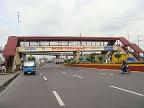 The avenue near Sucat Interchange | ||||
| Route information | ||||
| Maintained by Department of Public Works and Highways (DPWH) | ||||
| Length | 4.8 km (3.0 mi) | |||
| Major junctions | ||||
| West end |
| |||
| ||||
| East end |
| |||
| Location | ||||
| Major cities | Parañaque, Muntinlupa | |||
| Highway system | ||||
|
Roads in the Philippines
| ||||
.svg.png)
The Dr. Aracadio Santos Avenue or Dr. A. Santos Avenue, (formerly and still referred to as Sucat Road), is the primary east-west thoroughfare in Parañaque, southern Metro Manila, Philippines. The avenue's western end is at Victor Medina Street in the boundary between La Huerta and San Dionisio, as the continuation of Ninoy Aquino Avenue. Physically, Ninoy Aquino Avenue connects northbound to NAIA Road in Pasay which, in turn, continues west to Roxas Boulevard back in Parañaque, and then to Macapagal Boulevard, where it finally ends. Its eastern end is at South Luzon Expressway, at the city's border with Sucat, Muntinlupa, where it becomes Meralco Road to service the rest of the route to Sucat railway station.
History
The avenue was originally called Sucat Road and was named for the barrio in Muntinlupa and its railway station to which it led. Its present name is taken from Dr. Arcadio Santos, a native of Parañaque who was the governor of Rizal from 1920-1922 when the then-municipality was still part of the province.[1]
In September 2013, a bill was authored in the Philippine House of Representatives to rename Dr. Santos Avenue to President Cory Aquino Avenue. This bill authored by Rep. Eric Olivarez is still pending in the Committee on Public Works and Highways as of October 2013.[2]
The avenue will soon be served by the Manila Light Rail Transit Line 1 via Dr. A. Stantos Station to be constructed at the intersection with C-5 Road.
Route description
Dr. A. Santos Avenue runs through the villages of San Dionisio, San Isidro, San Antonio, BF Homes Parañaque and Sucat. It begins in San Dionisio as the continuation of Ninoy Aquino Avenue south of Ninoy Aquino International Airport Terminal 1, where the road narrows to three lanes from four. The road continues due east to cross C-5 Road Extension, N. Lopez Avenue and Presidents Avenue. It terminates at an interchange with South Luzon Expressway and the Manila Skyway.
The eastern section of the avenue is known as the location of two of Metro Manila's biggest cemeteries, Manila Memorial Park and Loyola Memorial Park. Notable places located along the road also include two SM shopping malls (SM City Sucat and SM City BF Parañaque), Amvel Business Park which houses the El Shaddai church, and the Santana Grove strip mall.
Intersections
Kilometers are indicated by yellow kilometer stones along the road. Mileage are rather measured from Kilometer Zero in Rizal Park. The whole road exists within Parañaque.
| City | km [3][4] | mi | Destinations | Notes | |
|---|---|---|---|---|---|
| Parañaque | 12.8455-19.280 | 7.96-11.797 | Victor Medina Street | Traffic light intersection. Continues north as Ninoy Aquino Avenue | |
| C-5 Road Extension | Interchange | ||||
| A. Canaynay Avenue | |||||
| N. Lopez Avenue | |||||
| Filipinas Avenue | |||||
| President's Avenue | |||||
| Skyway - Makati, Manila | Half-Y interchange. | ||||
| Parañaque-Muntinlupa boundary | South Luzon Expressway | Diamond interchange. Eastern terminus. Continues east as Meralco Road | |||
| 1.000 mi = 1.609 km; 1.000 km = 0.621 mi | |||||
Landmarks
Dr. A. Santos Avenue is home to several new commercial developments, particularly near its intersection with C-5 Road extension in San Dionisio, such as the Amvel City (formerly Amvel Business Park), SM City Sucat, Fields Residences, and Avida Towers Sucat. Another development on the avenue is the area near its intersection with President's Avenue in BF Homes which includes SM City BF Parañaque, Amaia Steps Sucat and Santana Grove which houses a Shopwise. This area is also the location of Medical Center Parañaque, Elorde Sports Center, the Manila Memorial Park and Loyola Memorial Park. The Parañaque City Hall is accessible by turning north on San Antonio Avenue near Jaka Plaza. Between Lopez Avenue and Canaynay Avenue are some of the older shopping centers on the avenue including WalterMart Sucat, Liana's Shopping Mall, Jaka Plaza, Savemore Sucat and Uniwide Warehouse Club Sucat (Now Super8). Olivarez College and Parañaque National High School are some of the biggest educational institutions located on the avenue near San Dionisio's border with the village of San Isidro.
References
- ↑ The Governors of Rizal Province published by the Rizal Provincial Government; accessed 2013-10-15.
- ↑ Hon. Olivarez, Eric L. published by House of Representatives of the Philippines; accessed 2013-10-15.
- ↑ "Metro Manila 2nd". Department of Public Works and Highways. Retrieved January 28, 2017.
- ↑ "Las Piñas-Muntinlupa". DPWH Road Atlas. Department of Public Works and Highways. Retrieved 28 December 2015.
Coordinates: 14°28′1″N 121°0′53″E / 14.46694°N 121.01472°E