Rizal Avenue
| |
|---|---|
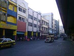 Rizal Avenue near Recto Avenue in Santa Cruz, Manila. | |
| Route information | |
| Length | 6.5 km (4.0 mi) |
| Component highways |
|
| Major junctions | |
| North end | Monumento in Caloocan |
|
9th Avenue Extension, 5th Avenue, R. Papa, Jose Abad Santos, Aurora Boulevard, Blumentritt Road, Tayuman Street, Bambang, Doroteo Jose, Claro M. Recto Avenue West Avenue (C3), EDSA (includes Rizal Ave. Extension) | |
| South end | Carriedo Street in Quiapo, Manila |
| Highway system | |
|
Roads in the Philippines | |
.svg.png)
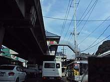
Rizal Avenue also known as "Avenida" or "Avenida Rizal" is one of Manila's main thoroughfares. Named after the national hero José Rizal, it is a part of Radial Road 9 (R-9). The LRTA's LRT Line 1 elevated railroad is built above the street in its entire length, and several jeepneys ply the area taking passengers from Caloocan and Quezon City. Most of the street is within the Sta. Cruz. By the 1960s, economic activities shifted from Binondo to Makati.
Contemporary landmarks
The LRT-1 stations are the main landmarks of the avenue; there are nine of them at Rizal Avenue.
At the northern end of the avenue is the Bonifacio Monument roundabout. Vehicles coming from Rizal Avenue's northbound carriageway can turn right into EDSA (Circumferential Road 4); its northern logical extension would be the MacArthur Highway (continuation of Radial Road 9), which leads all the way to Laoag, Ilocos Norte. Vehicles from Samson Road (EDSA's logical western extension) enter the avenue to its southbound carriageway.
The avenue also provides access to the entrance and exit gates of the Manila Chinese Cemetery. The San Lazaro Compound (which hosts the San Lazaro Hospital, the Dr. Jose Reyes Memorial Medical Center and the Department of Health) and the Archdiocesan Shrine of Espiritu Santo are the other landmarks along the avenue.
Shopping malls found along the Avenue are Araneta Square, Uniwide Sales, SM City San Lazaro (a walking distance from Tayuman Street) and at the south end at Carriedo Street is the Isetann Carriedo. In front of Isetann is Plaza Lacson (formerly Plaza Goiti). One passing through Plaza Lacson ends up in MacArthur Bridge, then to Taft Avenue (Radial Road 2), all the way up to the Taal Lake in Tagaytay. Eastbound takes one to Quiapo Church, although this part of the street has been pedestrianized
History
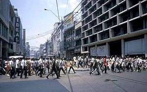
The Avenida Rizal was created by Manila City ordinance in 1911 from two streets – Calle Dulumbayan (literally the edge of town) and Calle Salcedo. It also called Calle Cervantes. It lengthened in the next two decades all the way up to Caloocan and the then new monument honoring Andres Bonifacio. It became the city's longest street before being overshadowed by EDSA later in the century. Prior to and right after World War II, the avenue was center of the city's social life, with the street lined with shops, restaurants and movie theaters. The theaters were designed by the prominent architects of the day, many of whom would become National Artists.[1][2]
Two National Artists for architecture, Pablo Antonio and Juan Nakpil, created several of the movie theaters along the avenue. Antonio designed the Galaxy, the Ideal, the Scala and the Lyric theaters, while Nakpil designed the Capitol, the Ever and the Avenue theaters. As the years went by, the area was victimized by urban renewal.
By the 1960s, economic activities shifted from the downtown area of Manila to Makati. The exodus of business and the rich residents from Manila to the suburbs coupled by the increase in low skilled rural migrants looking for work opportunities led to the deterioration of the old business districts, including Rizal Avenue. The construction of the LRT-1 in the 1980s, which required the closure of Rizal Avenue to vehicular traffic, essentially killed business along the route. The cinemas themselves resorted to showing double feature B-movies and soft porn, as people transferred to the newer and more modern Ortigas Center and the Ayala Center.[1]
In 2000, during the mayorship of Lito Atienza, the stretch from C.M. Recto Avenue to Palanca Street was turned into a pedestrian-only thoroughfare by laying bricks on the road, with the buildings and the LRT-1 painted as part of an urban renewal project. This caused vehicles to use the secondary roads such as Tomas Mapua and Doroteo Jose Streets in order to go to and from Plaza Lacson.[1][3] The Ideal Theater was previously demolished, the Galaxy, Scala and Lyric theaters are now misused. The first level of the Ever Theater is occupied by stalls, while the upper levels are abandoned. Only the refurbished Capitol Theater, now a dimsum palace, survived the modern times and is still active.[1] The pedestrianization of Rizal Avenue was completed on 2003 and was meant to only last for a short time but it has persisted until 2008.[3][4]
The Avenue Theater, which survived the Battle of Manila of 1945, was demolished in 2006 to give way to a parking area. The costs of maintaining the facility were too high, as compared for it to be converted as a parking area. The National Historical Institute (NHI) and several private entities tried to prevent the building from being torn down.[1]
One of Mayor Alfredo Lim 's first decisions after winning the elections of 2007 was to reopen the pedestrian-only section of Rizal Avenue, which has elicited complaints from shopkeepers due to decreased traffic of people, and from commuters which caused traffic jams on secondary streets.[4] Since the cost of the tiles for the pedestrianization was about P40 each, the tiles had been carefully removed for it to be used in future projects.[3] On July 17, 2007, Lim attended the ceremony reopening the closed portion of Rizal Avenue, and it has remained open to this day.[4]
Train stations along Rizal Avenue
All are LRT Line 1 stations:
In addition, the LRT Line 2 crosses the avenue at C.M. Recto Avenue, and the Recto Station is a short walk away from the avenue. The Philippine National Railways also crosses Rizal Avenue Extension, with Blumentritt railway station also a short walk away.
Other Rizal Avenues
"Rizal Avenue" and its variations thereof such as "Rizal Street" are one of the most common street names in the Philippines. It usually serves as the main street of a town or city, and in cases towns and cities in the Luzon mainland, the street that leads to Manila is "Rizal Street". J.P. Rizal Avenue in Makati is one such street.
Intersections
| Province | City/Municipality | km | mi | Destinations | Notes |
|---|---|---|---|---|---|
| Caloocan | Northern terminus. Continues north as MacArthur Highway. | ||||
| L. Bustamante Street | Northbound only. | ||||
| 12th Avenue | Southbound only. | ||||
| 11th Avenue | Both segments accessible thru nearby intersections. | ||||
| 10th Avenue | Traffic light intersection. | ||||
| 9th Avenue | Unsignaled intersection. | ||||
| 8th Avenue | Unsignaled intersection. | ||||
| 7th Avenue | Traffic light intersection. | ||||
| 6th Avenue | Unsignaled intersection. | ||||
| C-3 Road, 5th Avenue | Traffic light intersection. Westbound goes to R-10, eastbound goes to Quezon City. | ||||
| 4th Avenue | Traffic light intersection. | ||||
| 3rd Avenue | Unsignaled intersection. | ||||
| 2nd Avenue | Unsignaled intersection. | ||||
| 1st Avenue, 1st Avenue East | Southbound/Northbound only | ||||
| Manila | Ricardo Papa Street | Southbound only. | |||
| Tabora Street | Southbound only. | ||||
| Traffic light intersection. Southwest direction goes to Divisoria. | |||||
| Mt. Samat Street | Southbound only. | ||||
| Samal Street | Southbound only. | ||||
| Aurora Boulevard | Traffic light intersection. Access to La Loma and Sampaloc districts. | ||||
| Pampanga Street | Traffic light intersection. | ||||
| Bulacan Street | Northbound only. | ||||
| Sampaguita Street | Northbound only. | ||||
| Lico Street, Cavite Street | Traffic Light intersection. | ||||
| Blumentritt Road, Antipolo Street, Old Antipolo Street | Northeast direction goes to Aurora Boulevard and Dimasalang Street. | ||||
| Laguna Street | Traffic light intersection. | ||||
| Batangas Street | Traffic light intersection. | ||||
| Yuseco Street | Traffic light intersection. | ||||
| Herrera Street | Unsignaled intersection. | ||||
| Tayuman Street | Traffic light intersection. Westbound goes to R-10, Eastbound goes to Lacson Avenue. | ||||
| Malabon Street | Unsignaled intersection. | ||||
| San Lazaro Street | One-way intersection. | ||||
| Quiricada Street | Traffic light intersection. | ||||
| Alvarez Street | Unsignaled intersection. | ||||
| Bambang Street | Traffic light intersection. | ||||
| Remigio Street | Traffic light intersection. | ||||
| Mayhaligue Street | Unsignaled intersection. | ||||
| Fugoso Street | Traffic light intersection. | ||||
| Lope de Vega Street | Unsignaled intersection. | ||||
| Doroteo Jose Street | Unsignaled intersection. | ||||
| Traffic light intersection. Westbound goes to Divisoria and R-10; Eastbound goes to Sampaloc, San Miguel and Santa Mesa districts. | |||||
| Soler Street | Unsignaled intersection. | ||||
| Katubusan Street | Southbound only. | ||||
| Gonzalo Puyat Street | Unsignaled intersection. | ||||
| Ronquillo Street | One-way road from Rizal Avenue. | ||||
| Bustos Street | One-way road to Rizal Avenue. | ||||
| Carriedo Street | Southern terminus. | ||||
| 1.000 mi = 1.609 km; 1.000 km = 0.621 mi | |||||
See also
References
- 1 2 3 4 5 Alcazaren, Paulo (5 March 2005). "Manila's Broadway". The Philippine Star. Philstar.com. Retrieved 25 March 2012.
- ↑ Jalbuena, Katice (4 June 2006). "Rizal Avenue landmark gone". The Manila Times. Yehey.com. Retrieved 20 January 2009.
- 1 2 3 Lopez, Allison (2 July 2007). "Lim reopens Rizal Avenue, forest park". The Philippine Daily Inquirer. Archived from the original on September 14, 2007. Retrieved 20 January 2009.
- 1 2 3 Lopez, Allison (17 July 2007). "Rizal Avenue old-timers welcome reopening". The Philippine Daily Inquirer. Archived from the original on September 14, 2007. Retrieved 20 January 2009.
| Wikimedia Commons has media related to Rizal Avenue. |
Coordinates: 14°36′56″N 120°58′57″E / 14.61556°N 120.98250°E