Kalaw Avenue
| ||||
|---|---|---|---|---|
| T.M. Kalaw Street | ||||
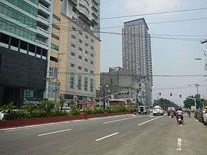 Kalaw Avenue looking west from Mabini Street | ||||
| Route information | ||||
| Length | 1.1 km (0.7 mi) | |||
| Major junctions | ||||
| From |
| |||
|
Maria Orosa Avenue Mabini Street Del Pilar Street | ||||
| To |
| |||
| Highway system | ||||
|
Roads in the Philippines
| ||||
.svg.png)
Kalaw Avenue (formerly T.M. Kalaw Street) is a short stretch of road in the Ermita district of Manila, Philippines. It forms the southern boundary of Rizal Park running east-west from San Marcelino Street to Roxas Boulevard near the center of the city. It begins as a four-lane road at the intersection with San Marcelino widening to an eight-lane divided roadway along the stretch of Rizal Park from Taft Avenue west to Roxas Boulevard. It has a short extension into the reclaimed area of Luneta and Quirino Grandstand as South Drive. The avenue is wholly assigned as National Route 155 (N155).
The avenue was named after Teodoro Kalaw, a Filipino legislator and historian of the Philippine Commonwealth period who also served as Director of the National Library of the Philippines (whose post-War incarnation lies along the street). It was formerly known as San Luis Street (Spanish: calle San Luis).[1]
Landmarks

Kalaw Avenue is the main access to some of Rizal Park's main attractions, such as the Museum of Natural History (former Department of Tourism Building), Museo Pambata, National Library of the Philippines and Manila Ocean Park. Just across the street from Rizal Park are the Central United Methodist Church, Luneta Hotel, and Eton Baypark residential tower. The Casino Español de Manila, destroyed during World War II, was rebuilt on its original site in 1951 near the avenue's intersection with Taft Avenue. It houses the Instituto Cervantes de Manila. Also located at this eastern end of Kalaw are Plaza Salamanca, Manila Prince Hotel and Masagana Superstore (SM Savemore). The National Historical Commission of the Philippines has its headquarters in Rizal Park on Kalaw Avenue just beside the National Library.
See also
References
- ↑ Remembrances and the streets of Manila published by Philippine Daily Inquirer; accessed 2013-10-08.
| Wikimedia Commons has media related to Kalaw Avenue. |
Coordinates: 14°34′53″N 120°58′50″E / 14.58139°N 120.98056°E