Philippine expressway network
| Philippine expressway network | |
|---|---|
_sign.svg.png) .svg.png) Shields for E2 / AH26 (Pan–Philippine Highway) and E5 (expressway) | |
 Map of expressways in Luzon, with the Subic–Clark–Tarlac Expressway in red | |
| System information | |
| Maintained by private companies under concession from the Department of Public Works and Highways | |
| Length | 420 km[1] (260 mi) |
| Highway names | |
| Expressways | Ex |
| System links | |
|
Roads in the Philippines | |
The Philippine expressway network is a controlled-access highway network managed by the Department of Public Works and Highways which consists of all expressways and regional high standard highways in the Philippines.[2] High standard highways are defined as highways which provide a high level of traffic services by assuring high speed mobility and safe travel in order to vitally support socio-economic activities for sound socio-economic development of strategic regions and the country as a whole.[2] In the Philippines, controlled-access highways are known as expressways. They are multi-lane divided toll roads which are privately maintained under concession from the government. The regional high standard highways are partial controlled-access highways that function as supplementary to expressways.[2]
The Philippine expressway network spanned 420 kilometers (260 mi) in length in 2015 and it is to be extended to 626 kilometers (389 mi) by 2020 and 995 kilometers (618 mi) beyond 2030 according to the master plan submitted by the Japan International Cooperation Agency in 2010.[1]
Overview
The Philippine highway network spans over 32,000 kilometers (20,000 mi) across all regions of the Philippines. These highways, however, are mostly single and dual carriageways with many U-turn lanes and intersections slowing down traffic. Coupled with the increase in the number of vehicles and the demand for limited-access highways, the Philippine government requested the government of Japan to conduct a master plan for the development of a high standard highway network in 2009 under the Philippine Medium-Term Public Investment Plan (2005–2010).[2] The plan calls for the promotion of national integrity by strengthening the Philippine Nautical Highway System linking roads and ferries, the decongestion of traffic in Metro Manila, and the improvement of accessibility to main tourist spots, among others.[2]
The Philippine expressway network master plan covers the development of high standard highways surrounding Metro Manila in Luzon, Metro Cebu in the Visayas, and the Metro Davao–General Santos area in Mindanao.[2]
Types
High standard highways in the Philippines are classified into two types: the arterial high standard highways or expressways, and regional high standard highways.[2]
Expressways (HSH-1)
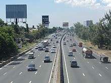
Arterial high standards highways (HSH-1) in the Philippines are known as expressways. They are highways with limited access, normally with interchanges and may include facilities for levying tolls for passage in an open or closed system.[3] Standard features of Philippine expressways include guard rails, rumble strips, signs and pavement markings, solid wall fence, speed radars, toll plaza, closed-circuit television and rest and service areas. The speed limit is 100 km/h for cars and jeepneys, 80 km/h for trucks and buses, and 60 km/h is the minimum for all classes of vehicles.
The first expressways in the Philippines are the North Luzon Expressway, formerly known as North Diversion Road and the South Luzon Expressway (SLEx), formerly known as South Super Highway. Both were built in the 1970s during the presidency of Ferdinand Marcos. The first elevated toll road in the Philippines is the Skyway or the South Metro Manila Skyway Project, built from 1995 to 1999 during the presidencies of Fidel Ramos and Joseph Estrada. The Southern Tagalog Arterial Road (STAR) Tollway I, from Santo Tomas to Lipa in Batangas was opened in 2001. STAR Tollway II, from Lipa to the Batangas City Port, opened in 2008. The Subic–Clark–Tarlac Expressway or SCTEx Project was initiated under the administration of former President Joseph Estrada with an original project cost of ₱15.73 billion. Construction was started in 2005 under the government of President Gloria Macapagal Arroyo. It is the longest tollway in the Philippines that connects Subic Bay Freeport, Clark Freeport and Tarlac City. It was completed with a project cost of ₱34.957 billion. In 2008, the SCTEx was formally opened, setting the stage for the development of the Tarlac–Pangasinan–La Union Expressway, which would extend beyond the SCTEx' terminus in Tarlac City.
There are many under construction and proposed expressways in the Philippines. All the expressways in the Philippines are privately maintained under concession agreements with the Department of Public Works and Highways through build–operate–transfer (BOT) arrangements. At present, there are 10 expressways in the Philippines that connect Metro Manila to northern and southern Luzon.
Regional high standard highways (HSH-2)
Regional high standard highways in the Philippines are multi-lane arterial roads with bypass, grade separation and/or frontage road. They connect the expressways and are mostly partial controlled-access highways.[2] Their design speed is 80–100 km/h for inter-urban regional highways and 60 km/h for intra-urban highways.[2]
Numbering system
Under the Route Numbering System of the Department of Public Works and Highways, expressways are labelled with pentagonal yellow signs with black numerals. They are prefixed by the letter "E" for "Expressway" and are numbered continuously.[3]
Numbered routes
The Philippine expressway network consists of the following routes, as of 2018:[4]
| Image | Route | From | To | Length | Toll roads | Areas served | Notes |
|---|---|---|---|---|---|---|---|
 |
Quezon City | Rosario | North Luzon Expressway Subic–Clark–Tarlac Expressway Tarlac–Pangasinan–La Union Expressway |
Bulacan, La Union, Northern Metro Manila, Pampanga, Pangasinan, Tarlac | |||
 |
Makati | Batangas City | Skyway South Luzon Expressway Southern Tagalog Arterial Road |
Batangas, Cavite, Laguna, Southern Metro Manila | |||
 |
Muntinlupa | Bacoor | Muntinlupa–Cavite Expressway | Southern Metro Manila, Cavite | Spur of E2 | ||
 |
Parañaque | Kawit | 14 km (8.7 mi) | Manila–Cavite Expressway | Cavite, Southern Metro Manila | ||
 |
Olongapo | Mabalacat | Subic–Tipo Expressway Subic–Clark–Tarlac Expressway |
Bataan, Pampanga, Zambales | |||
 |
Quezon City | Valenzuela | North Luzon Expressway Mindanao Avenue-Karuhatan Link | Northern Metro Manila | |||
 |
Parañaque | Pasay | NAIA Expressway | Southern Metro Manila including Ninoy Aquino International Airport |
Asian Highway Network
Asian Highway 26/Pan-Philippine Highway (![]()
_sign.svg.png)
See also
References
- 1 2 "Master Plan for High Standard Highways/Expressways for PPP". Department of Public Works and Highways. Retrieved 15 May 2017.
- 1 2 3 4 5 6 7 8 9 "The Study of Masterplan on High Standard Highway Network Development in the Republic of the Philippines" (PDF). Japan International Cooperation Agency. July 2010. Retrieved 15 May 2017.
- 1 2 "Brief History of National Roads in the Philippines" (PDF). Department of Public Works and Highways. Retrieved 15 May 2017.
- ↑ "2015 DPWH Road Data". Department of Public Works and Highways. Retrieved 15 May 2017.
| Existing |
| |||||||||||||
|---|---|---|---|---|---|---|---|---|---|---|---|---|---|---|
| Proposed |
| |||||||||||||
| Under Construction | ||||||||||||||
See also: Philippine highway network | ||||||||||||||
Roads in Asia | |
|---|---|
| Sovereign states |
|
| States with limited recognition |
|
| Dependencies and other territories | |
| |