Taguig
| Taguig Tagíg | ||
|---|---|---|
| Highly-Urbanized City | ||
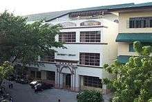
 (From top, left to right): Bonifacio Global City, Santa Ana Church, Taguig City Hall, Napindan Parola, Arca South | ||
| ||
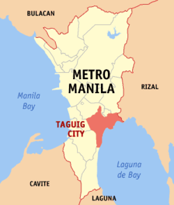 Location within Metro Manila | ||
.svg.png) Taguig Location within the Philippines | ||
| Coordinates: 14°31′N 121°03′E / 14.52°N 121.05°ECoordinates: 14°31′N 121°03′E / 14.52°N 121.05°E | ||
| Country | Philippines | |
| Region | National Capital Region | |
| Districts | 1st and 2nd Districts of Taguig City | |
| Incorporated | April 25, 1587 (town) | |
| Cityhood | December 8, 2004 | |
| Barangays | 28 | |
| Government[1] | ||
| • Mayor |
Lani Cayetano (Nacionalista) | |
| • Vice Mayor |
Ricardo Cruz (Nacionalista) | |
| • City Representatives | ||
| • City Council | ||
| Area[2][3] | ||
| • Total | 45.18 km2 (17.44 sq mi) | |
| Elevation | 16.0 m (52.5 ft) | |
| Population (2015 census)[4] | ||
| • Total | 804,915 | |
| • Density | 18,000/km2 (46,000/sq mi) | |
| Time zone | UTC+8 (PST) | |
| Zip code | 1630–1638 | |
| Area code | +63 (0)02 | |
| Website |
www | |

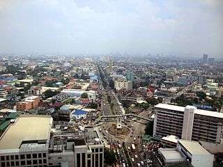
Taguig (Tagalog: Tagíg, pronounced [taˈɡiɡ], officially the City of Taguig, Filipino: Lungsod ng Tagíg) is a highly urbanized city located in the south-eastern portion of Metro Manila in the Philippines. From being a thriving fishing community along the shores of Laguna de Bay, it is now an important residential, commercial and industrial center. According to the 2015 census, Taguig is the seventh-most populous city in the Philippines, after Zamboanga City; it has a population of 804,915.[4]
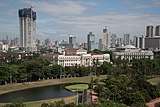
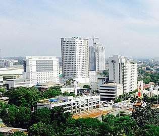
The local government of Taguig currently administers Bonifacio Global City, which is considered as one of Metro Manila's central business districts alongside Makati CBD and Ortigas Center. Other future developments in the city include Arca South (formerly known as Food Terminal Incorporated) Ayala Land's 70-hectare business and lifestyle district,[5] and Laguna de Bay Lakeshore Development along the Bulacan–Rizal–Manila–Cavite Regional Expressway (C-6 Road).[6]
Taguig lies on the western shore of Laguna de Bay and is bordered by Muntinlupa to the south, Parañaque to the southwest, Pasay to the west, Cainta and Taytay on the northeast and Makati, Pateros, and Pasig to the north. The Taguig River, a tributary of the Pasig River, cuts through the northern half of the municipality and Napindan River, also a tributary of the Pasig forms the common border of Taguig with Pasig.
Etymology
The original farmer-fishermen of the area, about 800 in number, were good at threshing rice after harvest. Hence they were referred to as "mga taga-giik," (Tagalog for "rice thresher") and the settlement as "pook ng mga taga-giik." Spanish friar Fray Alonso de Alvarado, together with conquistador Ruy López de Villalobos who crossed Pasig River to reach the city's present site in 1571, found "taga-giik" difficult to pronounce. "Tagui-ig" was later shortened to its current form "Taguig".[7]
History
Before the Spaniards came, Taguig was a part of Namayan and Tondo ruled by Lakandula. There were also accounts that Chinese settlements were once present in the area as revealed by the recent archaeological diggings of various artifacts like cups, plates and other utensils, which bear Chinese characters. This was believed to have originated from China's Ming dynasty.
Taguig was one of the earliest known territories to have been Christianized when the Spaniards succeeded in subjugating mainland Luzon through the Legazpi expedition in 1571. Between the years 1582 and 1583, Taguig was part of the encomienda of Tondo headed by an alcalde mayor, Captain Vergara. It was in 1587 when Taguig was established as a separate "pueblo" (town) of the then province of Manila. Captain Juan Basi was its Kapitan from 1587 to 1588. According to records, Taguig had nine (9) barrios then namely, Bagumbayan, Bambang, Hagonoy, Palingon, Sta. Ana, Tipas, Tuktukan, Ususan, and Wawa. Records show that Tipas had once petitioned to become an independent town but was denied by the Spanish government.
During that time, Taguig was accessible via the Pasig River, which was connected to two large bodies of water, the Manila Bay and Laguna de Bay. The population then was estimated to be 800 tributes. The town produced more than enough rice for consumption but had less sugar cane to mill. The men lived through fishing while women wove cotton cloth and "sawali" from bamboo strips. The people of Taguig were known to have resisted both Spanish and American colonial rule. During that early period of Spanish colonization. Don Juan Basi, "Kapitan" of Taguig from 1587 to 1588, took part in the Tondo Conspiracy, an attempt to overthrow the Spanish government which failed. Basi was exiled for two years as punishment. When the Katipunan was on its early years, many from Taguig became followers and later joined the uprising. The people of Taguig also joined the revolutionary government of General Emilio Aguinaldo on August 6, 1898.
During the American occupation, they struggled against the forces of General Wheaton under the command of General Pio del Pilar. It was recorded that on February 6, 1898, Filipino forces including Taguig "revolutionarios" dislodged an American position in the hills of Taguig, now a portion of Pateros and Fort Bonifacio. They were defeated eventually by the Americans with superiority in the armaments and training. Taguig finally fell to the contingent of the First Washington Volunteer Infantry led by Col. Wholly.
The defeat of the Filipinos after two years of struggle against the American forces subsequently subjected the Philippines to another system of governance. On August 14, 1898, United States occupied the islands and established a military government with General Wesley Meritt as the First Military Governor. He exercised legislative powers until September 1, 1900. At the start of American occupation, Taguig was proclaimed as an independent municipality with the promulgation of General Order No. 4 on March 29, 1900. The town was subsequently incorporated to the newly created province of Rizal when the Philippine Commission promulgated Act. No. 137 on June 11, 1901. On October 12, 1903, Taguig, Muntinlupa and Pateros were merged by the virtue of Act. No. 942 with Pateros hosting the seat of the municipal government. The merger did not last long as a month later Muntinlupa was segregated from it and made part of Biñan when Act. No. 1008 was enacted on November 25, 1903. However it was returned to Taguig on March 22, 1905 with the promulgation Act. No. 1308. On February 29, 1908, Taguig was again declared an independent municipality through Executive Order No. 20. Eventually, Pateros separated from Taguig and both became independent municipalities of Rizal province on January 1, 1918.
It was also during the American Colonial Period that the US government acquired a 25.78 km² property of Taguig for military purposes. This large piece of land, which had a TCT dated 1902, was turned into a camp that became known as Fort McKinley (named after William McKinley, 25th president of the U.S.). When the Japanese occupied the Philippines in 1942, Fort McKinley was taken over by the Japanese Imperial Army. They occupied the military camp until the end of the war in 1945. After the Philippines gained its political independence from the United States on July 4, 1946, the US surrendered the Republic of the Philippines all right of possession, jurisdiction, supervision and control over the Philippine territory except the use of the military bases. On May 14, 1949, Fort William McKinley was turned over to the Philippine government by virtue of the US Embassy Note No. 0570. Fort McKinley was made the permanent headquarters of the Philippine Army in 1957 and was subsequently renamed Fort Bonifacio after the Father of the Philippine Revolution against Spain, Andres Bonifacio.
The town's political subdivision was changed to barangays following the nationwide implementation of the Integrated Reorganization Plan (IRP) in the 1970s when the country was under Martial Law. The IRP has increased its subdivisions into 18 barangays, namely, Bagong Tanyag, Bagumbayan, Bambang, Calzada, Hagonoy, Ibayo-Tipas, Ligid-Tipas, Lower Bicutan, Maharlika, Napindan, Palingon, Signal Village, Sta. Ana, Tuktukan, Upper Bicutan, Ususan, Wawa, and Western Bicutan. In the year 2009, Taguig re-organized and re-arranged the barangays making a total of 28, the 10 added being Central Bicutan, Fort Bonifacio, South Daanghari, North Daanghari, San Miguel, New Lower Bicutan, South Signal,Katuparan, North Signal, Pinagsama and Tanyag. On November 7, 1975, Taguig was carved out from the province of Rizal to form the National Capital Region through Presidential Decree No. 824. Today, Taguig is still one of the 17 cities and municipalities that make up Metro Manila.
In 1998, a bill was passed in Congress pushing for the cityhood of Taguig. The resulting plebiscite in April showed that the citizens were against cityhood. A recent petition to the Supreme Court sought a recount of the plebiscite and the Supreme Court on February 19, 2004 ordered the Commission on Elections to conduct a recount. The recount showed that the residents did want the municipality of Taguig to become a city (21,105 'yes' and 19,460 'no'). Subsequently, Taguig became a city on December 8, 2004.
In 2008, the Taguig City council enacted City Ordinances Nos. 24–27, 57–61, 67–69, and 78, Series of 2008 which created 10 new barangays, carving them out from the initial 18 barangays. Hence, in December 2008, after a successful plebiscite, Taguig was politically subdivided into 28 barangays.
(Reference: History of Taguig[8])
Demographics
| Population census of Taguig | |||||||||||||||||||||||||||||||||||||||||||||||||
|---|---|---|---|---|---|---|---|---|---|---|---|---|---|---|---|---|---|---|---|---|---|---|---|---|---|---|---|---|---|---|---|---|---|---|---|---|---|---|---|---|---|---|---|---|---|---|---|---|---|
|
| ||||||||||||||||||||||||||||||||||||||||||||||||
| Source: Philippine Statistics Authority[4][9][10][11] | |||||||||||||||||||||||||||||||||||||||||||||||||
Local government
Like other cities in the Philippines, Taguig is governed by a mayor and vice mayor who are elected to three-year terms. The mayor is the executive head and leads the city's departments in executing the city ordinances and improving public services. The city mayor is restricted to three consecutive terms, totaling nine years, although a mayor can be elected again after an interruption of one term. The vice mayor heads a legislative council consisting of 18 members: 8 councilors from the First District, 8 councilors from the Second District, the president of the Sangguniang Kabataan (Youth Council) Federation, representing the youth sector, and the president of the Association of Barangay Chairmen (ABC) as barangay sectoral representative. The council is in charge of creating the city's policies in the form of Ordinances and Resolutions.[12]
The current mayor for the 2016–2019 term is Lani Cayetano. She currently holds the youngest and 1st female mayor of Taguig. Ricardo Cruz, former councilor and Barangay Chairman of Lower Bicutan is the city's incumbent vice mayor. Current district representatives of the city are Arnel Cerafica, representing the 1st district and Pia S. Cayetano, representing the 2nd district.
Official seal
Meaning of the official seal's elements:
- Skyblue ray – signifies the 28 barangays of the city
- 1587 – Don Juan Basi, "Capitan" of Taguig from 1587 to 1588, took part in the Tondo Conspiracy, an attempt to overthrow the Spanish government which failed, this is the official revolt against the Spaniards
- 2004 – the year Taguig was officially proclaimed a City.
- Napindan parola – was built during the Spanish era, as an entrance to Pasig river from laguna de bay.
- City Hall – symbolize the central government of Taguig
- Pacific Plaza Towers in BGC – symbolizes progress as these twin towers are the first buildings in Bonifacio Global City.
- Fish & Carabao – symbolize the humble beginnings of the people of Taguig as farmers and fishermen.
- Eagle – represents the city's soaring economy and progressive governance.
Boundary dispute
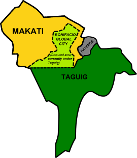
Makati and Taguig have recently fought over the jurisdiction of Fort Bonifacio. This Philippine military base, most of which has been converted to a modern commercial and residential development area, lies in an ambiguous area. A portion of the base, including the Libingan ng mga Bayani (Heroes' Cemetery) and the Manila American Cemetery and Memorial lies within Taguig, while the northern portion where the development center is now located used to be considered part of Makati, but is currently and permanently considered part of Taguig. A 2003 ruling by a judge in the Pasig Regional Trial Court has upheld the jurisdiction of Taguig over the whole of Fort Bonifacio, including Barangay Pinagsama and Bonifacio Global City.
Ruling
The Supreme Court on June 27, 2008 per Leonardo Quisumbing, dismissed the suit of the Makati, seeking to nullify Special Patents 3595 and 3596 signed by Fidel Ramos conveying to the Bases Conversion and Development Authority public land in Fort Bonifacio, Taguig. Because of a pending civil case filed by the Taguig City government asking the court to define its territorial boundaries, Makati therefore cannot stop Taguig from collecting taxes on land located in Fort Bonifacio.[13][14] Taguig is competing with Makati, where round-the-clock construction of office and residential towers, as well as hotels and retail and commercial areas, BPO and call centers, are now transferring to Taguig.
Court of Appeals decisions
On August 5, 2013, the Court of Appeals declared almost the entire Fort Bonifacio, parts of Barangay Western Bicutan and parts of Barangay Pinagsama are under the territorial jurisdiction of Makati[15][16]
Status Quo prevails

On August 22, 2013, Taguig filed a Motion for Reconsideration before the Court of Appeal's Sixth Division affirming its claim on Fort Bonifacio.[17]
"Taguig's claim has the backing of history—it precedes Makati as a political and corporate entity by decades. Taguig's claim has the weight of official authority behind it—in statutes, in proclamations, in public documents—while Makati can only rely on private writings and proclamations that expand the original terms of that which it sought to amend", part of the motion read.
"Taguig's claim has been established by the numerous documentary and official documents, while Makati's has been one characterized by numerous legal maneuvers and overreliance on technicalities", the motion added. With the filing of the said Motion for Reconsideration, Taguig's jurisdiction forces itself over Fort Bonifacio. According to Taguig's legal department, jurisprudence and the rules of procedure in the country's justice system all say that the filing of a motion for reconsideration suspends the execution of a decision and puts it in limbo.
Supreme Court's 2nd Decision
On August 1, 2016, in a 27-page decision by the Second Division of the Supreme Court, the decision sought Makati government found guilty of direct contempt for abusing the legal processes over the jurisdiction of BGC.[18]
Final decision
On October 3, 2017, the Court of Appeals upheld its final decision in favor of Taguig City government and not Makati. The SC also sought Makati guilty of forum shopping after simultaneously appealing the Pasig RTC ruling and filing a petition before the CA, both seeking the same relief.[19][20]
Barangays
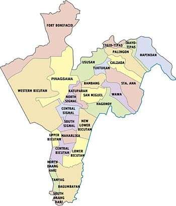
Taguig is politically subdivided into 28 barangays. In December 2008, ten new barangays were created in the city after a successful plebiscite by virtue of City Ordinance Nos. 24–27, 57–61, 67–69, and 78, Series of 2008.[21]
| First District | ||
|---|---|---|
| Barangay | Barangay Chairman | Population (2015)[22] |
| Bagumbayan | Sergio B. Cruz | 40,685 |
| Bambang | Jaime T. Cruz Jr. | 10,010 |
| Calzada-Tipas | Virgilio E. Maglipon | 21,747 |
| Hagonoy | Renato Gutierrez | 18,652 |
| Ibayo–Tipas | Erwin Mendiola | 20,932 |
| Ligid–Tipas | May Fe Mañosca | 9,700 |
| Lower Bicutan | Roel Pacayra | 56,754 |
| New Lower Bicutan | Gregorio S. Franco | 49,829 |
| Napindan | Rosanna R. San Pedro | 19,346 |
| Palingon-Tipas | Jerome M. Mendiola | 13,705 |
| San Miguel | Vicente G. Espital | 8,590 |
| Santa Ana | Conrado Aquino JR | 18,057 |
| Tuktukan | Arsenio C. De Guzman | 10,730 |
| Ususan | Marie Marcelino | 54,186 |
| Wawa | Phillip E. Buenaflor | 11,177 |
- Parts of Hagonoy became under the jurisdiction of a new barangay San Miguel
- Lower Bicutan was divided into two, the other one to be known as Barangay New Lower Bicutan
| Second District | ||
|---|---|---|
| Barangay | Brgy. Chairman | Population (2015)[22] |
| Central Bicutan | Jennifer F. Alit | 28,705 |
| Central Signal Village | Pat Henry A. Duenas | 39,674 |
| Fort Bonifacio | Wilfredo Sayson | 11,739 |
| Katuparan | Edgar Victor S. Baptista | 23,062 |
| Maharlika Village | Yasser G. Pangandaman | 22,944 |
| North Daang Hari | Lorenzo O. Fortuno | 11,771 |
| North Signal Village | Jesus J. Pullente | 32,112 |
| Greater Pinagsama | Ma.Victoria M. Mortel-Balidoy | 57,343 |
| South Daang Hari | Ma. Lourdes Pagsisihan | 19,166 |
| South Signal Village | Michelle Anne Odivilas | 39,214 |
| Tanyag | Joseph S. Sucaldito | 22,711 |
| Upper Bicutan | Alexander S. Penolio | 41,216 |
| Western Bicutan | Nicky C. Supan | 91,158 |
- Signal Village was divided into four barangays, Central Signal Village (originating barangay), Katuparan, North Signal Village, and South Signal Village.
- Bagong Tanyag was divided into three barangays, North Daang Hari, South Daang Hari, and Tanyag proper (originating barangay)
- Parts of Upper Bicutan became under the jurisdiction of a new barangay Central Bicutan
- Western Bicutan was divided into three barangays, Fort Bonifacio, Pinagsama and Western Bicutan (originating barangay).
Education
Taguig City[23] is home to several prestigious international schools which provide international education to Metro Manila residents, such as the British School Manila, Everest Academy Manila, International School Manila, and Manila Japanese School, which are all located in the University Parkway of Bonifacio Global City. The Chinese International School Manila, Enderun Colleges, and Korean International School Philippines are in the nearby area of McKinley Hill, while The Beacon School is located along the nearby Chino Roces Avenue.
Other schools in Fort Bonifacio are the STI College Global City, Global City Innovative College, Leaders International Christian School of Manila (Christian-based curriculum), Victory Leadership Institute, and MGC-New Life Christian Academy.
Two of the top state universities are also in Taguig—the Polytechnic University of the Philippines, and the Technological University of the Philippines. Both universities are located within the city in Central Bicutan and Western Bicutan.
In 2016, the University of the Philippines inaugurated its campus in Bonifacio Global City for its law programs.[24] Following that year in 2017, the De La Salle University College of Law opened its Rufino Campus at Bonifacio Global City's University Parkway Drive.[25]
Enderun Colleges, an affiliate of Les Roches International School of Hotel Management-Switzerland is an undergraduate college and management school in the Philippines that offers a full range of bachelor's degree and non-degree courses in the fields of international hospitality management and business administration.[26] Likewise, The Meridian International College or MINT, a tertiary educational institution of arts, business and technology are both located in McKinley Hill, Barangay Pinagsama, Taguig City.[27]
Taguig City University, the city's local state university located in Central Bicutan started operations in November 2006.[28]
The Technical Education and Skills Development Authority (TESDA) was established through the enactment of "Technical Education and Skills Development Act of 1994", which was signed into law by President Fidel V. Ramos. This Act aims to encourage the full participation of and mobilize the industry, labor, local government units, and technical-vocational institutions in the skills development of the country's human resource. The TESDA complex and facilities are located at the East Service Road of the South Luzon Expressway in Taguig.
The Philippine Public Safety College in Fort Bonifacio is an educational institution offering undergraduate and graduate programs for the training, human resource development, and continuing education of police, fire and jail personnel.
Taguig has two Islamic educational institutions located in Maharlika Village—the Maharlika Bandara-Inged Integrated School and the Maharlika Village Islamic Madrasa.
Other notable schools in Taguig include the city's Science High Schools Taguig Science High School in Brgy. San Miguel, Senator Renato "Compañero" Cayetano Memorial Science and Technology High School in Ususan, Taguig National High School, a state-owned secondary institution in New Lower Bicutan, the Catholic Church-owned Colegio de Sta. Ana (formerly Sta. Ana Parochial School), The Fisher Valley College, a Christian school in Hagonoy and Pinagsama and Saint Francis of Assisi College System, a Catholic school in Bagumbayan.
Taguig is set to become the new "university city" of Metro Manila as new campuses of University of the Philippines Professional Schools and De La Salle University are located in Bonifacio Global City.[29][30]
Notable people
 Pia Cayetano, congresswoman
.jpg) Alan Peter Cayetano, Secretary of Foreign Affairs
Alan Peter Cayetano, Secretary of Foreign Affairs Bea Alonzo, actress
- Dante Tiñga, former Associate Justice
- Rene Cayetano, former Senator
- Felix Y. Manalo, Iglesia Ni Cristo Preacher
- Lino Cayetano, TV/movie director & former Congressman
- Jamalul Kiram III, claimant to throne of Sultanate of Sulu
- Ervic Vijandre, actor
- Precious Lara Quigaman, actress and Miss International 2005 titleholder
- Lance Lucido, Filipino child actor
- Rene Facunla Humpshire a.k.a Ate Glow, Filipino Actor/Commediane/Impersonator
- Lucita Soriano, actress
- Groups
- Taguig Renegade Drum and Lyre Corps, 3 time National Drum and Lyre champion
International relations
Diplomatic missions
Countries that have set up permanent missions or offices in the city include:
Sister cities
The local government of Taguig maintains relations with other cities in the Philippines.
| Local |
|---|
| Bacolod, Negros Occidental[31] |
| Tarlac City, Tarlac |
| Tabaco, Albay[32] |
| Vigan, Ilocos Sur[33] |
References
- ↑ "Cities". Quezon City, Philippines: Department of the Interior and Local Government. Archived from the original on March 9, 2013. Retrieved November 15, 2012.
- ↑ "An Update on the Earthquake Hazards and Risk Assessment of Greater Metropolitan Manila Area" (PDF). Philippine Institute of Volcanology and Seismology. November 14, 2013. Archived from the original (PDF) on June 24, 2016. Retrieved May 16, 2016.
- ↑ "Enhancing Risk Analysis Capacities for Flood, Tropical Cyclone Severe Wind and Earthquake for the Greater Metro Manila Area Component 5 – Earthquake Risk Analysis" (PDF). Philippine Institute of Volcanology and Seismology and Geoscience Australia. Retrieved May 16, 2016.
- 1 2 3 Census of Population (2015). "National Capital Region (NCR)". Total Population by Province, City, Municipality and Barangay. PSA. Retrieved 20 June 2016.
- ↑ Aragona, Mark (September 18, 2014). "Ayala invests P80-billion for a new business and lifestyle district". Arca South. Yahoo Southeast Asia. Archived from the original on December 4, 2014. Retrieved April 18, 2016.
- ↑ "Taguig to develop C-6 road". Yahoo News. 2013-06-30. Retrieved 2016-04-18.
- ↑ "History". Official Website of The City of Taguig. Retrieved 2016-04-18.
- ↑ "History of Taguig". City Government Of Taguig. 2013. Retrieved November 15, 2017.
- ↑ Census of Population and Housing (2010). "National Capital Region (NCR)". Total Population by Province, City, Municipality and Barangay. NSO. Retrieved 29 June 2016.
- ↑ Censuses of Population (1903–2007). "National Capital Region (NCR)". Table 1. Population Enumerated in Various Censuses by Province/Highly Urbanized City: 1903 to 2007. NSO.
- ↑ "Province of Metro Manila, 4th (Not a Province)". Municipality Population Data. Local Water Utilities Administration Research Division. Retrieved 17 December 2016.
- ↑ "R.A. 7160". www.lawphil.net. Retrieved 2016-04-18.
- ↑ Court junks Makati's suit to nullify Ramos patents, manilastandardtoday.com; accessed August 10, 2015.
- ↑ Binay v Taguig, G.R. No. 163175, June 27, 2008 Archived July 10, 2008, at the Wayback Machine., supremecourt.gov.ph; accessed August 10, 2015.
- ↑ Court of Appeals declares Fort Bonifacio, parts of Western Bicutan and parts of Pinagsama as part of Makati City, gmanetwork.com; accessed August 10, 2015.
- ↑ Fort Bonifacio-Makati dispute, rappler.com; accessed August 10, 2015.
- ↑ Taguig reaffirms claim over Fort Bonifacio, taguig.gov.ph; accessed August 10, 2015.
- ↑ Torres-Tupas, Tetch (August 1, 2016). "Makati guilty of direct contempt over BGC row with Taguig". Philippine Daily Inquirer. Retrieved January 22, 2017.
- ↑ Ramos, Marlon (November 6, 2017). "CA: Taguig owns BGC, not Makati". Philippine Daily Inquirer. Retrieved December 18, 2017.
- ↑ Punay, Edu (November 6, 2017). "It's final: BGC belongs to Taguig". The Philippine Star. Retrieved December 18, 2017.
- ↑ Villanueva, Rhodina (2009-05-10). "Taguig names heads of city's 10 new barangays". philstar.com. Retrieved 2016-04-18.
- 1 2 Total Population by Province, City, Municipality and Barangay: as of May 1, 2010 Archived June 25, 2012, at the Wayback Machine. – Philippine Statistics Authority
- ↑ Taguig city book
- ↑ ,
- ↑ Yee, Jovic. "DLSU inaugurates law campus in Bonifacio Global City".
- ↑ https://www.enderuncolleges.com/about/
- ↑ "Our Story". MINT College.
- ↑ Taguig University will have own campus in 2009 Archived February 22, 2008, at the Wayback Machine., newsinfo.inquirer.net; accessed August 10, 2015.
- ↑ Frialde, Mike (July 21, 2015). "Taguig to become 'university city' with new UP, DLSU campuses". The Philippine Star. Archived from the original on January 14, 2016. Retrieved February 1, 2016.
- ↑ "Taguig becoming a 'University City'". Official Website of The City of Taguig. Retrieved 2016-02-01.
- ↑ "Council approves sisterhood, twinning with Taguig". SunStar. May 11, 2012. Archived from the original on June 16, 2013.
- ↑ "RESOLUTION EXPRESSING INTENTION FOR SISTERHOOD AND TWINNING WITH TAGUIG CITY". Tabaco City.com. March 21, 2011.
- ↑ "A RESOLUTION EXTENDING AN INVITATION TO THE CITY OF TAGUIG TO BECOME A SISTER CITY OF VIGAN, ILOCOS SUR" (PDF). City of Vigan. February 18, 2008.
External links
| Wikimedia Commons has media related to Taguig. |
| Wikivoyage has a travel guide for Taguig. |
- Official Website of Taguig
- Think Big Taguig - Official Lifestyle Website
- Official Facebook page of City of Taguig
- Bonifacio Global City

Places adjacent to Taguig | |
|---|---|