Nashua, New Hampshire
| Nashua, New Hampshire | ||
|---|---|---|
| City | ||
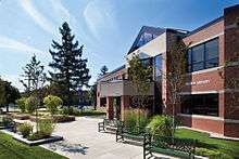
 Main Street in downtown Nashua | ||
| ||
| Nickname(s): Gate City | ||
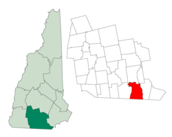 Location in Hillsborough County, New Hampshire | ||
| Coordinates: 42°45′27″N 71°27′52″W / 42.75750°N 71.46444°WCoordinates: 42°45′27″N 71°27′52″W / 42.75750°N 71.46444°W | ||
| Country | United States | |
| State | New Hampshire | |
| County | Hillsborough | |
| Settled | 1655 | |
| Town | 1746 | |
| City | 1853 | |
| Government | ||
| • Mayor | Jim Donchess | |
| • Board of Aldermen[1] |
Members
| |
| Area | ||
| • Total | 31.9 sq mi (82.6 km2) | |
| • Land | 30.8 sq mi (79.9 km2) | |
| • Water | 1.0 sq mi (2.7 km2) 3.25% | |
| Elevation | 151 ft (46 m) | |
| Population (2010)[2] | ||
| • Total | 86,494 | |
| • Estimate (2016)[3] | 87,882 | |
| • Density | 2,849/sq mi (1,099.9/km2) | |
| Time zone | UTC−5 (Eastern) | |
| • Summer (DST) | UTC−4 (Eastern) | |
| ZIP codes |
| |
| Area code(s) | 603 | |
| FIPS code | 33-50260 | |
| GNIS feature ID | 0868677 | |
| Website |
www | |
Nashua is a city in Hillsborough County, New Hampshire, United States. As of the 2010 census, Nashua had a population of 86,494,[2] making it the second-largest city in the state after Manchester. As of 2016 the population had risen to an estimated 87,882.[3]
Built around the now-departed textile industry, in recent decades it has been swept up in southern New Hampshire's economic expansion as part of the Boston region. Nashua was twice named "Best Place to Live in America" in annual surveys by Money magazine.[4] It is the only city to get the No. 1 ranking on two occasions—in 1987 and 1998.
History
The area was part of a 200-square-mile (520 km2) tract of land in Massachusetts called "Dunstable", which had been awarded to Edward Tyng of Dunstable, England. Nashua lies approximately in the center of the original 1673 grant. In 1732, Dunstable was split along the Merrimack River, with the town of Nottingham (now the town of Hudson, New Hampshire) created out of the eastern portion. The previously disputed boundary between Massachusetts and New Hampshire was fixed in 1741 when the governorships of the two provinces were separated. As a result, the township of Dunstable was divided in two. Tyngsborough and some of Dunstable remained in Massachusetts, while Dunstable, New Hampshire, was incorporated in 1746 from the northern section of the town.
Located at the confluence of the Nashua and Merrimack rivers, Dunstable was first settled about 1654 as a fur trading town. Like many 19th century riverfront New England communities, it would be developed during the Industrial Revolution with textile mills operated from water power. By 1836, the Nashua Manufacturing Company had built three cotton mills which produced 9.3 million yards of cloth annually on 710 looms. On December 31, 1836, the New Hampshire half of Dunstable was renamed "Nashua", after the Nashua River, by a declaration of the New Hampshire legislature (the Dunstable name lives on across the Massachusetts border).[5] The Nashua River was named by the Nashuway Indians, and in the Penacook language it means "beautiful stream with a pebbly bottom",[6] with an alternative meaning of "land between two rivers".[7] In 1842 the town split again in two for eleven years following a dispute between the area north of the Nashua, and the area south of the river. During that time the northern area (today "French Hill") called itself "Nashville", while the southern part kept the name Nashua.[5] They reconciled in 1853 and joined together to charter the "city of Nashua".[5] Six railroad lines crossed the mill town, namely the Boston, Lowell and Nashua; Worcester and Nashua; Nashua and Acton; Nashua and Wilton; Concord and Nashua; and Rochester railroads; with 56 trains entering and departing daily in the years before the Civil War.[5][8] These various railroads led to all sections of the country, north, east, south, and west. The Jackson Manufacturing Company employed hundreds of workers in the 1870s.[9]
Like the rival Amoskeag Manufacturing Company upriver in Manchester, the Nashua mills prospered until about World War I, after which a slow decline set in. Water power was replaced with newer forms of energy to run factories. Cotton could be manufactured into fabric where it grew, saving transportation costs. The textile business started moving to the South during the Great Depression, with the last mill closing in 1949. Many citizens were left unemployed. But then Sanders Associates, a newly created defense firm that is now part of BAE Systems, moved into one of the closed mills and launched the city's rebirth. Besides being credited with reviving the city's economy, Sanders Associates also played a key role in the development of the home video game console market. Ralph H. Baer, an employee of Sanders, developed what would become the Magnavox Odyssey, the first commercial home video game system. Sam Tamposi is credited with much of the city's revival. The arrival of Digital Equipment Corp. (now part of Hewlett-Packard) in the 1970s made the city part of the Boston-area high-tech corridor.
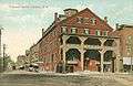 Tremont House c. 1908
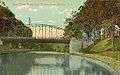 Canal St. Bridge, c. 1908
 The Willows, c. 1910; the road is now Route 101A near Somerset Plaza
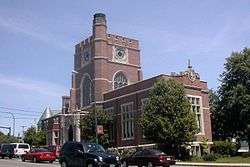 Hunt Memorial Library in 2006
Geography

Nashua is in southeastern Hillsborough County at 42°45′04″N 71°28′51″W / 42.751038°N 71.480817°W (42.751038, −71.480817).[10] It is bordered to the south by Middlesex County, Massachusetts.
According to the United States Census Bureau, the city has a total area of 31.9 square miles (82.6 km2), of which 30.8 square miles (79.9 km2) is land and 1.0 square mile (2.7 km2) is water, comprising 3.25% of the city.[11] The eastern boundary of Nashua is formed by the Merrimack River, and the city is drained by the Nashua River and Salmon Brook, tributaries of the Merrimack. The Nashua River roughly bisects the city. Pennichuck Brook forms the city's northern boundary. The highest point in Nashua is Gilboa Hill in the southern part of the city, at 426 feet (130 m) above sea level.[12]
The city is bordered on the east by the Merrimack River, across which lies the town of Hudson, New Hampshire.
Climate
Nashua has a four-season humid continental climate (Köppen Dfb), with long, cold, snowy winters, and very warm and somewhat humid summers; spring and autumn in between are relatively brief transitions. The monthly daily average temperature ranges from 22.7 °F (−5.2 °C) in January to 70.9 °F (21.6 °C) in July. On average, there are 9.4 days of 90 °F (32 °C)+ highs and 8.7 days of sub-0 °F (−18 °C) lows. Precipitation is well-spread throughout the year, though winter is the driest. Snowfall, the heaviest of which typically comes from nor'easters, averages around 55 inches (140 cm) per season, but can vary widely from year to year.
| Climate data for Nashua, New Hampshire | |||||||||||||
|---|---|---|---|---|---|---|---|---|---|---|---|---|---|
| Month | Jan | Feb | Mar | Apr | May | Jun | Jul | Aug | Sep | Oct | Nov | Dec | Year |
| Average high °F (°C) | 33.2 (0.7) |
37.2 (2.9) |
45.2 (7.3) |
57.9 (14.4) |
68.9 (20.5) |
77.3 (25.2) |
82.4 (28) |
81.1 (27.3) |
73.3 (22.9) |
61.5 (16.4) |
50.1 (10.1) |
38.5 (3.6) |
59.0 (15) |
| Average low °F (°C) | 12.3 (−10.9) |
15.2 (−9.3) |
23.4 (−4.8) |
33.6 (0.9) |
44.1 (6.7) |
54.0 (12.2) |
59.3 (15.2) |
57.6 (14.2) |
49.3 (9.6) |
37.2 (2.9) |
29.3 (−1.5) |
19.4 (−7) |
36.3 (2.4) |
| Average precipitation inches (mm) | 3.42 (86.9) |
3.36 (85.3) |
4.30 (109.2) |
4.36 (110.7) |
4.07 (103.4) |
4.40 (111.8) |
3.88 (98.6) |
3.91 (99.3) |
3.72 (94.5) |
4.44 (112.8) |
4.26 (108.2) |
3.85 (97.8) |
47.97 (1,218.5) |
| Average snowfall inches (cm) | 16.5 (41.9) |
13.2 (33.5) |
10.7 (27.2) |
0.8 (2) |
0 (0) |
0 (0) |
0 (0) |
0 (0) |
0 (0) |
trace | 2.1 (5.3) |
11.6 (29.5) |
54.9 (139.4) |
| Average precipitation days (≥ 0.01 in) | 9.4 | 8.5 | 9.9 | 11.0 | 12.0 | 11.5 | 10.4 | 9.1 | 8.8 | 9.9 | 10.7 | 9.6 | 120.8 |
| Average snowy days (≥ 0.1 in) | 5.7 | 4.2 | 3.5 | 0.4 | 0 | 0 | 0 | 0 | 0 | 0 | 1.0 | 3.9 | 18.7 |
| Source: NOAA (normals 1981−2010)[13] | |||||||||||||
Demographics
| Historical population | |||
|---|---|---|---|
| Census | Pop. | %± | |
| 1790 | 632 | — | |
| 1800 | 862 | 36.4% | |
| 1810 | 1,049 | 21.7% | |
| 1820 | 1,142 | 8.9% | |
| 1830 | 2,417 | 111.6% | |
| 1840 | 6,054 | 150.5% | |
| 1850 | 5,820 | −3.9% | |
| 1860 | 10,065 | 72.9% | |
| 1870 | 10,543 | 4.7% | |
| 1880 | 13,397 | 27.1% | |
| 1890 | 19,311 | 44.1% | |
| 1900 | 23,898 | 23.8% | |
| 1910 | 26,005 | 8.8% | |
| 1920 | 28,379 | 9.1% | |
| 1930 | 31,463 | 10.9% | |
| 1940 | 32,927 | 4.7% | |
| 1950 | 34,669 | 5.3% | |
| 1960 | 39,096 | 12.8% | |
| 1970 | 55,820 | 42.8% | |
| 1980 | 67,865 | 21.6% | |
| 1990 | 79,662 | 17.4% | |
| 2000 | 86,605 | 8.7% | |
| 2010 | 86,494 | −0.1% | |
| Est. 2016 | 87,882 | [3] | 1.6% |
| U.S. Decennial Census[14] | |||
As of the census of 2010,[15] there were 86,494 people, 35,044 households, and 21,876 families residing in the city. The population density was 2,719.9 people per square mile (1,050.2/km2). There were 37,168 housing units at an average density of 1,202.8 per square mile (464.6/km2). The racial makeup of the city was 83.4% White, 2.7% African American, 0.3% Native American, 6.5% Asian, 0.03% Pacific Islander, 4.6% from some other race, and 2.5% from two or more races. Hispanic or Latino of any race were 9.8% of the population.
There were 35,044 households out of which 28.7% had children under the age of 18 living with them, 45.9% were married couples living together, 11.6% had a female householder with no husband present, and 37.6% were non-families. 29.4% of all households were made up of individuals and 9.6% had someone living alone who was 65 years of age or older. The average household size was 2.42 and the average family size was 3.01.
In the city the population was spread out with 22.1% under the age of 18, 9.3% from 18 to 24, 28.0% from 25 to 44, 27.8% from 45 to 64, and 12.7% who were 65 years of age or older. The median age was 38.5 years. For every 100 females, there were 97.3 males. For every 100 females age 18 and over, there were 95.8 males.
In 2011 the estimated median income for a household in the city was $60,923, and the median income for a family was $76,612. Male full-time workers had a median income of $60,365 versus $43,212 for females. The per capita income for the city was $30,937. About 4.6% of families and 9.3% of the population were below the poverty line, including 11.4% of those under age 18 and 5.9% of those age 65 or over.[16]
Government
| Year | GOP | DEM | Others |
|---|---|---|---|
| 2016 | 40.78% 17,476 | 52.95% 22,690 | 6.27% 2,685 |
| 2012 | 42.28% 17,658 | 56.07% 23,413 | 1.65% 689 |
| 2008 | 42.63% 17,325 | 56.36% 22,902 | 1.01% 409 |
| 2004 | 45.08% 18,016 | 54.02% 21,587 | 0.90% 358 |
| 2000 | 42.84% 14,803 | 53.24% 18,398 | 3.92% 1,353 |
| 1996 | 36.53% 11,525 | 52.72% 16,632 | 10.75% 3,393 |
| 1992 | 34.51% 12,514 | 40.75% 14,777 | 24.74% 8,970 |
The city's government is headed by a mayor and fifteen aldermen: six at-large aldermen elected three at a time every four years, and nine ward aldermen, one for each ward in the city, elected every two years.
In the New Hampshire General Court, Nashua is represented in the House by Hillsborough County's 20th (Ward 1), 21st (Ward 2), 22nd (Ward 3), 23rd (Ward 4), 24th (Ward 6), 25th (Ward 7) and 26th (Wards 5, 8 and 9) districts and in the Senate by District 12 (Wards 1, 2, and 5, shared with Hollis, Mason, Brookline, Greenville, New Ipswich, and Rindge) and District 13 (Wards 3, 4, 6, 7, 8, and 9).
In the New Hampshire Senate, Nashua is represented by two state senators:
- Republican Kevin Avard (District 12) – Wards 1-2, 5
- Democrat Bette Lasky (District 13) – Wards 3-4, 6-9
In the New Hampshire Executive Council, Nashua is included within the 5th District and is currently represented by Republican David K. Wheeler. Nashua is included within New Hampshire's 2nd congressional district and is currently represented by Democrat Ann McLane Kuster in the U.S. House of Representatives.
At the presidential level, Nashua leans Democratic. No Republican presidential nominee has carried the city in over two decades.
Nashua Fire Rescue
The fire department of Nashua, Nashua Fire, has 176 full-time members and is responsible for 31.9 square miles (83 km2), protecting a population of 87,259. In the city, there are six stations. There is one fire chief, one assistant chief, and four deputy chiefs. The department has six engines, three ladder trucks, two spare engines, one spare ladder, two hazmat trucks, and two forestry trucks.[18] Nashua uses a private ambulance service, AMR (American Medical Response ). The department has 5 fire commissioners. The commission has overall responsibility for the policy decisions, promotions, discipline, hiring and terminations. The fire chief reports directly to the commission. Their responsibility is to also work with Fire Administration with planning and prioritizing the department budget.[19]
Economy
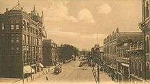
Nashua has three main commercial districts. Centered on Main Street near the geographic center of the city, Downtown Nashua is the oldest of the commercial districts, featuring commercial, entertainment, and dining venues, near historic commercial buildings and homes as well. Recent plans have incorporated the Nashua River into the design of a pedestrian-friendly walkway. The downtown Nashua Riverwalk is a large, public/private venture funded through the use of tax increment financing (TIF). Amherst Street (Route 101A) is in the northwestern part of the city and is a large thoroughfare with commercial centers along both sides. The South Nashua Commercial District, centered on Daniel Webster Highway near the Massachusetts border, is anchored by the Pheasant Lane Mall, attracting many people from Massachusetts taking advantage of the lack of sales tax in New Hampshire.
The city is home to a number of technical firms, including Nashua Corporation, which took its name from the city and river. Nashua Corp. was a leading producer of floppy disks through the early 1990s, making the Nashua name well known in the world of personal computers.
Defense contractor BAE Systems (formerly Sanders Associates), computer firm Dell,[20] and software company Oracle Corporation are the largest representatives of the high-tech industry prominent in the region. The Boston Air Route Traffic Control Center is in Nashua. The three-building campus that once housed a Digital Equipment Corporation software development facility was sold to the John Flatley Company, which has renamed it "Nashua Technology Park".[21]
In 2015, after four years of construction, the city completed the Broad Street Parkway,[22] which connects Exit 6 of the Everett Turnpike to the city's downtown area ("Tree Streets" neighborhood), with the goal of easing traffic congestion and opening up Nashua's old mill-yard as part of the city's economic development.[23] The new parkway provides a third crossing of the Nashua River and a way for traffic to avoid Library Hill, a busy downtown intersection. The idea of a road connecting Broad Street with Hollis Street within the city had been discussed since the 1960s.[24]
The city is currently working with Renaissance Downtowns, a Plainville, New York, development company, to develop a mixed commercial and residential development on 26 acres (11 ha) of city- and privately owned land off Bridge Street. A riverfront location and proximity to downtown have made the site attractive to developers. The property is 1⁄2 mile (800 m) from Main Street and lies along the Nashua and Merrimack rivers near Veterans Memorial Bridge, the eastern gateway to the city.[25]
There are two hospitals in Nashua, St. Joseph Hospital and Southern New Hampshire Health System.
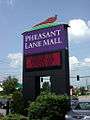 One of three pre-2012 matching signs to the Pheasant Lane Mall
 Dining outdoors in Downtown Nashua
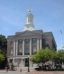
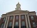 Nashua's City Hall - Winter 2014
Transportation

Road transport
The Everett Turnpike is the major highway running through the city. U.S. Route 3 follows the turnpike from the Massachusetts border north to Exit 7E, where it branches to the northeast along the two-lane Henri A. Burque Highway to Concord Street and then heads north into the town of Merrimack. Other New Hampshire state highways in the city include:
- NH 101A, which enters the city from the northwest and follows Amherst Street to its terminus at Main Street.
- NH 111, which enters the city from the southwest and follows Hollis Street to the city's eastern border at the Merrimack River, crossing into Hudson on the twin-span Taylor Falls/Veterans Memorial bridges.
- NH 111A, which enters the city from the southwest and follows Groton Road to Main Dunstable Road to its terminus at Hollis Street.
- NH 130, which enters the city from the west and follows Broad Street to its terminus at Amherst Street.
Maps of the Nashua area often show a stretch of freeway forming a circumferential highway through Nashua and the neighboring town of Hudson. Only a small section of the south end of this highway (Exit 2 off U.S. Route 3) has been built, and it is unclear whether the highway will ever be completed. If finished, the Nashua-Hudson Circumferential Highway would be part of the Everett Turnpike, and would rejoin the mainline highway at a hypothetical Exit 9 in northern Nashua.
Public transportation is provided by the Nashua Transit System, which has nine scheduled bus routes in the city. Boston Express, a subsidiary of Concord Trailways, operates a Nashua-Boston bus line that runs out of the Nashua Transit Center off Exit 8 on the Everett Turnpike. This line transports passengers to South Station and Logan International Airport in Boston.[26]
Airports
Nashua Airport (Boire Field), a general aviation facility, is in the city's northwest corner. The nearest airports with scheduled airline service are Manchester–Boston Regional Airport in Manchester and Logan International Airport in Boston.
Historical
Historically, Nashua was a hub for the trolley system in New Hampshire. Trolleys could be taken south to Boston, as well as north into Manchester and to locations as far east as Hampton, New Hampshire. The trolley also connected different areas of the city, with the Nashua line ending at the city dance hall. The trolley system decreased in popularity in the 20th century, finally closing in 1932.[27]
Future development
Efforts are being made to extend the Massachusetts Bay Transportation Authority's commuter rail Lowell Line from Lowell to Nashua. The state legislature created the New Hampshire Rail Transit Authority (NHRTA) in 2007 with the goal of overseeing the development of commuter rail in the state. Currently, proposed commuter rail stops include Nashua, Manchester, and Concord.[28]
The Board of Aldermen signed a memorandum of understanding, on October 11, 2017, with the Boston Surface Railroad Company in the creation of a commuter rail line in the near future. The proposed line would connect Lowell, Massachusetts, to Bedford, New Hampshire, with the end station being near the Manchester–Boston Regional Airport.[29]
Media
The city has a daily newspaper, The Telegraph.
Nashua radio stations include WGHM 900 AM (ESPN affiliate), talk WSMN 1590 AM, back on the air after going dark in January 2005, and 106.3 WFNQ, a classic hits station owned by Nassau Broadcasting Partners. WEVS 88.3 and 90.3 serve as the stations for New Hampshire Public Radio.
One television station is licensed to Nashua. WYCN-CD (channel 15) is owned by NBC Owned Television Stations, carrying a simulcast of NBC O&O WBTS-LD for the entire Boston market and into southern New Hampshire. The station moved from its own transmitter to a channel share with PBS member station WGBX-TV from their Needham, Massachusetts tower in 2018 upon NBC's assumption of ownership, letting it broadcast the "NBC Boston" service across the entire market. It formerly carried a number of smaller networks, along with local programming and community calendar information of interest to Nashuans.
The city of Nashua also provides three channels of PEG Access television. Nashua Government TV can be found on Comcast cable channel 16, and Nashua ETV (Educational Television) can be found on Channel 99. The city of Nashua also contracts out the operation of its Public Access Channel (Access Nashua) to Community Media Services group. Access Nashua can be found on Comcast cable channel 96. All three Nashua PEG Access channels also stream their content and offer video-on-demand through the city website.
Education
In the 2000 U.S Census, 22,700 residents over age three were enrolled in a Nashua educational institution, approximately a fourth of the city.[30]
Secondary schools
- Public
In 2004, Nashua's public high school was split into Nashua High School South (home of the Purple Panthers, opened in 1976 and rebuilt/reopened in 2004) and the new Nashua High School North (home of the Titans, opened in 2002) off Broad Street.
Before Nashua High School (now Nashua High School South) opened in 1976, what is now Elm Street Middle School was the city's high school. With the new high school opening in 1976, the old high school became Elm Street Junior High School. In 2004, the school became Elm Street Middle School, after a citywide reorganization of grades: Nashua's elementary schools went from [K]-1-6 to [K]-1-5, and junior high schools serving grades 7-9 were replaced by middle schools serving grades 6-8. Elm Street is still commonly referred to as Elm St. Junior High by many city residents and officials.
- Private
- Bishop Guertin High School, a coeducational Catholic high school
- Public charter school
Middle schools
- Public
- Elm Street Middle School
- Fairgrounds Middle School
- Pennichuck Middle School
- Private
- Nashua Catholic Junior High School
- World Academy
Colleges
Nashua is home to Nashua Community College (NCC), Rivier University, Southern New Hampshire University's Nashua campus, and a branch of Granite State College, which is on NCC’s campus.[31]
Daniel Webster College (DWC) closed in May 2017 after its parent company ITT Tech declared bankruptcy. Its campus was adjacent to the Nashua Airport. Southern New Hampshire University agreed to absorb DWC's faculty and academic programs, and placed the winning bid for DWC's flight center, tower building, and hangar.[32]
Sports
Nashua has had a series of amateur, semi-professional, and professional baseball teams. The Nashua Silver Knights, part of a summer collegiate league, is the city's current team. The Nashua Pride, a Can-Am minor league baseball team, played at Holman Stadium from 1998 through 2008, then changed to the American Defenders of New Hampshire in the 2009 season. The Defenders were evicted from the venue in August 2009, however, because of non-payment of rent, and moved to Pittsfield, Massachusetts to become the Pittsfield Colonials. Before the Pride, Holman was the home stadium for the independent Nashua Hawks; the AA Nashua Pirates; the AA Nashua Angels; and the A Nashua Dodgers, the first racially integrated professional baseball team in the 20th century.[33]
In collegiate sports, Nashua is home to the Rivier University Raiders, who compete in the Great Northeast Athletic Conference (GNAC).
The Spartans Drum and Bugle Corps (1997, 1998, 2004, and 2007 Drum Corps International Division II World Champions) is based in Nashua.
Notable people
Sister cities
In popular culture
A few episodes of the US television show The Office were set in a fictional Nashua branch of Dunder Mifflin as Michael Scott's love interest and future wife, Holly Flax, lives in Nashua after being transferred. The character Pam Beesly joked the Nashua branch "is only accessible through cross country skiing".
An episode of MTV's MADE was filmed in 2004 at Nashua High School North.[36]
In an episode of the second season of The West Wing, "In the Shadow of Two Gunmen, Part II", during a flashback Josh Lyman visits a town hall meeting in Nashua to see a candidate he could support. The candidate turns out to be Josiah Bartlet, the next President of the United States.
In Good Will Hunting, Matt Damon's character Will Hunting says, "I wanna move up to Nashua, get a nice little spread, get some sheep and tend to them," to Robin Williams' character Sean.[37]
Russian dressing was created in Nashua by James E. Colburn, likely in the 1910s.[38]
See also
References
- ↑ Board of Aldermen on Nashua town website
- 1 2 "Geographic Identifiers: 2010 Demographic Profile Data (G001): Nashua city, New Hampshire". U.S. Census Bureau, American Factfinder. Retrieved December 18, 2015.
- 1 2 3 "Population and Housing Unit Estimates". Retrieved June 9, 2017.
- ↑ Meighan, Patrick (July 13, 2010). "Nashua cracks Money's top 100". Nashua Telegraph. Retrieved March 29, 2017.
- 1 2 3 4 "History of Nashua". City of Nashua. Retrieved March 29, 2017.
- ↑ "NIAC Publications ~ Nipmuc Place Names - Maine & Massachusetts". www.nativetech.org.
- ↑ "A Short History of Nashua" on the city website Archived 2013-11-10 at the Wayback Machine.
- ↑ http://gedcomindex.com/Reference/New_Hampshire_1875/264.html [Statistics and Gazetteer of New Hampshire, 1875]
- ↑ http://gedcomindex.com/Reference/New_Hampshire_1875/265.html [Statistics and Gazetteer of New Hampshire, 1875.]
- ↑ "US Gazetteer files: 2010, 2000, and 1990". United States Census Bureau. 2011-02-12. Retrieved 2011-04-23.
- ↑ "Geographic Identifiers: 2010 Demographic Profile Data (G001): Nashua city, New Hampshire". U.S. Census Bureau, American Factfinder. Retrieved November 5, 2014.
- ↑ "City of Nashua Conservation and Preservation, Section B ("Natural Nashua"), Section 1 ("Topography")". Archived from the original on November 5, 2014. Retrieved November 4, 2012.
- ↑ "Station Name: NH NASHUA 2 NNW". National Oceanic and Atmospheric Administration. Retrieved 2013-03-12.
- ↑ "U.S. Decennial Census". Census.gov. Archived from the original on May 12, 2015. Retrieved November 4, 2014.
- ↑ "Profile of General Population and Housing Characteristics: 2010 Demographic Profile Data, Nashua city, New Hampshire". U.S. Census Bureau, American FactFinder. Archived from the original on September 11, 2013. Retrieved November 9, 2011.
- ↑ "Selected Economic Characteristics: 2011 American Community Survey 1-Year Estimates (DP03), Nashua city, New Hampshire". U.S. Census Bureau. Retrieved February 22, 2013.
- ↑ http://sos.nh.gov/ElectResults.aspx
- ↑ "Fire Rescue News - Nashua, NH". www.nashuanh.gov.
- ↑ "Nashua, NH". www.nashuanh.gov.
- ↑ "Archived copy". Archived from the original on 2013-01-21. Retrieved 2016-02-06.
- ↑ "Nashua Technology Park".
- ↑ "Broad Street Parkway". Broad Street Parkway
- ↑ Rich-Kern, Sheryl (December 19, 2015). "Long-awaited Broad Street Parkway Opens in Nashua". New Hampshire Public Radio. Retrieved March 3, 2016.
- ↑ "Archived copy" (PDF). Archived from the original (PDF) on 2011-09-29. Retrieved 2011-05-02.
- ↑ "Archived copy" (PDF). Archived from the original (PDF) on 2011-08-25. Retrieved 2011-05-01.
- ↑
- ↑ "Archived copy" (PDF). Archived from the original (PDF) on 2016-03-04. Retrieved 2014-11-25.
- ↑ Chasse, Amelia. (2011-03-15) Business groups unite to support NH Rail Transit Authority « New Hampshire Journal Archived August 23, 2011, at the Wayback Machine.. Nhjournal.com. Retrieved on 2013-08-02.
- ↑ Wheeler, Christine DeLong (2017-10-11). "Commuter rail proposal continues to move forward". WMUR. Retrieved 2017-10-14.
- ↑ Bureau, U.S. Census. "American FactFinder - Results". factfinder.census.gov.
- ↑ CURTIS, DANIELLE (27 July 2012). "Nashua Community College, Granite State College partner on bachelor's degree program". Nashua Telegraph. Retrieved 29 August 2015.
- ↑ Moore, Jim (October 25, 2017). "Nonprofit college aviation program grows". AOPA. Retrieved November 28, 2017.
- ↑ Gray, Kevin (2005-10-06). "Don Newcombe diversity dinner speaker Jan. 16". New Hampshire Cultural Diversity Awareness Council. Archived from the original on 2007-10-17. Retrieved 2007-10-20.
As members of the Nashua Dodgers, Campanella and Newcombe were the first professional, African-American baseball players to compete on a racially integrated U.S. team in the 20th century.
- ↑ "Mysuru and Nashua sister cities to have bilateral relationship initiative - Mysuru Today". Mysuru Today. 2016-09-27. Retrieved 2017-10-01.
- ↑ Corwin, Emily. "Nashua Sees Development Opportunities In Voyage To Indian City". Retrieved 2017-10-01.
- ↑ "HippoPress -- The Hippo -- Guide to Manchester and Nashua NH". archives.hippopress.com.
- ↑ "Quotes from "Good Will Hunting"" – via www.imdb.com.
- ↑ Krupa, Michelle (March 29, 2017). "Russian dressing is actually from Nashua, New Hampshire". CNN. Retrieved March 29, 2017.
External links
| Wikimedia Commons has media related to Nashua, New Hampshire. |
| Wikivoyage has a travel guide for Nashua (New Hampshire). |
| Wikisource has the text of the 1911 Encyclopædia Britannica article Nashua. |
- City of Nashua official website
- Nashuahistory.com
- Nashua Historical Society
- Images of Nashua Historical Society
- Nashua Public Library
- Nashua Regional Planning Commission
- New Hampshire Economic and Labor Market Information Bureau Profile
- Images of Elm Street Middle School, formerly Nashua High School
- Images of Fairgrounds Elementary School
- Images of Mount Pleasant Elementary School
- Images of Nashua Regional Catholic Junior High School, formerly Mount Saint Mary’s High School for Young Women
- Images of Infant Jesus School, Infant Jesus Church and related buildings
- Images of Historic Holman Stadium
Places adjacent to Nashua, New Hampshire | |
|---|---|
Municipalities and communities of Hillsborough County, New Hampshire, United States | ||
|---|---|---|
| Cities | 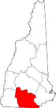 | |
| Towns | ||
| CDPs | ||
| Other villages | ||
| Topics | |||||||
|---|---|---|---|---|---|---|---|
| States | |||||||
| Major cities | |||||||
| State capitals | |||||||
| Transportation |
| ||||||
| |||||||