Woburn, Massachusetts
| Woburn, Massachusetts | ||
|---|---|---|
| City | ||
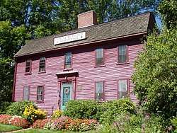 Benjamin Thompson House, Woburn, Massachusetts | ||
| ||
|
Motto(s): Industria et Virtute (Latin) "Industry and Virtue" | ||
 Location in Middlesex County, Massachusetts | ||
 Woburn, Massachusetts Location in the United States | ||
| Coordinates: 42°28′45″N 71°09′10″W / 42.47917°N 71.15278°WCoordinates: 42°28′45″N 71°09′10″W / 42.47917°N 71.15278°W | ||
| Country | United States | |
| State | Massachusetts | |
| County | Middlesex | |
| Settled | 1640 | |
| Incorporated | 1642 | |
| Government | ||
| • Type | Mayor-council city | |
| • City Mayor | Scott Galvin | |
| • Ward aldermen |
Rosa DiTucci (1) Richard F. Gately Jr. (2) Mark E. Gaffney (3) Luke M. Anderson (4) Darlene Mercer-Bruen (5) Michael L. Raymond (6) Raymond B. Drapeau (7) | |
| • At-large aldermen |
Paul J. Denaro Richard M. Haggerty | |
| Area | ||
| • Total | 12.9 sq mi (33.4 km2) | |
| • Land | 12.7 sq mi (32.8 km2) | |
| • Water | 0.2 sq mi (0.6 km2) | |
| Elevation | 100 ft (30 m) | |
| Population (2010) | ||
| • Total | 38,120 | |
| • Estimate (2016)[1] | 39,452 | |
| • Density | 3,000/sq mi (1,100/km2) | |
| Time zone | UTC−5 (Eastern) | |
| • Summer (DST) | UTC−4 (Eastern) | |
| ZIP code | 01801 / 01888 | |
| Area code(s) | 339 / 781 / And Sometimes 617 | |
| FIPS code | 25-81035 | |
| GNIS feature ID | 0612270 | |
| Website | www.woburnma.gov | |

Woburn (/ˈwuːbərn/ WOO-bərn) is a city in Middlesex County, Massachusetts, United States. The population was 38,120 at the 2010 census. Woburn is located 9 miles (14 km) north of Boston, Massachusetts.
History
Woburn was first settled in 1640 near Horn Pond, a primary source of the Mystic River, and was officially incorporated in 1642. At that time the area included present day towns of Woburn, Winchester, Burlington, and parts of Stoneham and Wilmington. In 1730 Wilmington separated from Woburn. In 1799 Burlington separated from Woburn; in 1850 Winchester did so, too.
Woburn got its name from Woburn, Bedfordshire. Woburn played host to the first religious ordination in the Americas on Nov. 22, 1642. Rev. Thomas Carter was sworn in by many of the most prominent men of New England including John Cotton, minister of the First Church of Boston, Richard Mather minister of the First Church of Dorchester, and Capt. Edward Johnson co-founder of the church and town of Woburn. Johnson is regarded as "the father of Woburn." He served as the first town clerk, represented the town in the Massachusetts General Court, made the first map of Massachusetts, and wrote the first history of the colony.[2]
The first organizational Town Meeting was held on April 13, 1644 and the first town officers were chosen. Town Selectmen were Edward Johnson, Edward Convers, John Mousall, William Learned, Ezekiel Richardson, Samuel Richardson and James Thompson. William Learned was also selected as Constable. Michael Bacon, Ralph Hill, Thomas Richardson were chosen as Surveyors of Highways. (The History of Woburn, 1868)
Deacon Edward Convers was also one of the founders of Woburn. He was one of its first selectmen, and built the first house and first mill in Woburn. He was very active in town affairs and was a large landowner, miller and surveyor.[3][4]
List of important events
- Gershom Flagg's tannery was built in 1668
- The Middlesex Canal was opened in 1803
- Thompson established a tannery at Cummingsville in 1823
- The Boston and Lowell Railroad started operating through Woburn in 1835
- The Woburn Sentinel newspaper began in 1839
- In 1840 the first membership library opened
- The telegraph started operating in Woburn in 1867
- "America's oldest active gun club," the Massachusetts Rifle Association, was founded in 1875 and moved to Woburn in 1876.
- The public library opened in 1879
- The telephone was introduced in Woburn in 1882; Electric lights in 1885
- Woburn was incorporated as a City on June 12, 1888
- Route 128 opened in 1951
- Route 93 was built through town in 1963
- Rail depot closed in 1962.
- Cummings Properties, the major holder of commercial properties in the region, was founded in 1970.
- Cummings Foundation was established in 1986.
- Cummings Foundation purchased the former Choate Memorial Hospital site and turned it into the New Horizons of Choate senior living community in 1990.
- Community Weeklies Inc. was founded by William S. Cummings and began publishing Woburn Advocate in 1991. The firm was bought by a division of Fidelity Investments in 1994, and Woburn Advocate is now being published by GateHouse Media.[5]
- Middlesex Superior Courthouse moved to TradeCenter 128 business campus in 2008.[6]
- The final phase of construction is completed on TradeCenter 128 business campus in 2010.[7]
- Woburn Police Officer John B. Maguire was killed in the line of duty while responding to an armed robbery on December 26, 2010.[8]
- Massachusetts Biotechnology Council awarded Woburn the platinum-level "Bio-Ready community" designation in 2011.[9]
Groundwater contamination incident
Woburn was the scene of a high-profile water contamination crisis. During the mid to late 1970s, the local community became concerned over the high incidence of childhood leukemia and other illnesses, particularly in the Pine Street area of east Woburn. After high levels of chemical contamination were found in City of Woburn’s Wells G and H in 1979, some members of the community suspected that the unusually high incidence of leukemia, cancer, and a wide variety of other health problems were linked to the possible exposure to volatile organic chemicals in the groundwater pumped from wells G and H.
In May 1982, a number of citizens whose children had developed or died from leukemia filed a civil lawsuit against two corporations, W. R. Grace and Company and Beatrice Foods. Grace's subsidiary, Cryovac, and Beatrice were suspected of contaminating the groundwater by improperly disposing of trichloroethylene (TCE), perchloroethylene (perc or PCE) and other industrial solvents at their facilities in Woburn near wells G and H.
In a controversial decision over what many considered a bungled trial (Judge Walter Jay Skinner ruled that the jurors should answer questions that they and many others considered confusing), Beatrice was acquitted and Grace only paid $8 million, a third of which went to the lawyers and lawyer fees. A United States Environmental Protection Agency report later found Beatrice and Grace responsible for the contamination.[10][11] A book titled A Civil Action was written about the case by Jonathan Harr.[12] In 1998 the book was turned into a movie starring John Travolta and Robert Duvall, also titled A Civil Action. The film was largely filmed in nearby Bedford and Lexington, with only a few shots on location in Woburn.
Geography
Woburn is located at 42°29′4″N 71°9′7″W / 42.48444°N 71.15194°W (42.484545, -71.152060).[13] It is bordered by the towns of Wilmington, Reading, Stoneham, Winchester, Lexington, and Burlington.
According to the United States Census Bureau, the city has a total area of 12.9 square miles (33 km2), of which 12.7 square miles (33 km2) is land and 0.2 square miles (0.52 km2) (1.71%) is water.
Climate
Woburn features a humid continental climate, similar to those of many of the other Boston suburban areas. It features moderately cold Winters, but not usually as bad as the ones around The Great Lakes Regions or Southern Canada, or even Northern New England. Nonetheless, it features occasional 'arctic blasts' which can easily drop the temperature below zero. Spring generally starts out cool, around 45-50 degrees, often with snow still on the ground. However, it quickly begins to rapidly warm to around 75 degrees by the time Summer begins. Summers are generally warm or hot & often accompanied with humidity, though not nearly as bad as cities in The Midwest & Mid-Atlantic, and even Rhode Island. Temperatures often top in the 80s, but when an Atlantic low comes, temperatures may fail to rise out of the 60s. High pressure from The Gulf of Mexico, occasionally brings much hotter conditions with temperatures sometimes topping near 100, though this is fairly rare and only happens so often. Falls are generally crisp, but start out warm with temperature highs around 70 & lows around 50. Quickly things cool, and it feels & looks like Winter with temperatures around 40 usually towards the end. Like most of the region, temperatures can vary widely in the span of a day.
Demographics
| Historical population | ||
|---|---|---|
| Year | Pop. | ±% |
| 1790 | 1,727 | — |
| 1800 | 1,228 | −28.9% |
| 1810 | 1,219 | −0.7% |
| 1820 | 1,519 | +24.6% |
| 1830 | 1,977 | +30.2% |
| 1840 | 2,993 | +51.4% |
| 1850 | 3,956 | +32.2% |
| 1860 | 6,287 | +58.9% |
| 1870 | 8,560 | +36.2% |
| 1880 | 10,931 | +27.7% |
| 1890 | 13,499 | +23.5% |
| 1900 | 14,254 | +5.6% |
| 1910 | 15,308 | +7.4% |
| 1920 | 16,574 | +8.3% |
| 1930 | 19,434 | +17.3% |
| 1940 | 19,751 | +1.6% |
| 1950 | 20,492 | +3.8% |
| 1960 | 31,214 | +52.3% |
| 1970 | 37,406 | +19.8% |
| 1980 | 36,626 | −2.1% |
| 1990 | 35,943 | −1.9% |
| 2000 | 37,258 | +3.7% |
| 2010 | 38,120 | +2.3% |
| 2016 | 39,452 | +3.5% |
| * = population estimate. Source: United States Census records and Population Estimates Program data.[14][15][16][17][18][19][20][21][22][23][24] Source: | ||
As of the census[26] of 2000, there were 37,258 people (37,010 by 2006 estimate), 14,997 households, and 9,658 families residing in the city. The population density was 2,939.6 people per square mile (1,135.4/km²). There were 15,391 housing units at an average density of 1,214.3 per square mile (469.0/km²). The racial makeup of the city was 90.57% White, 1.87% African American, 0.10% Native American, 4.85% Asian, 0.05% Pacific Islander, 1.44% from other races, and 1.13% from two or more races. Hispanic or Latino of any race were 3.09% of the population.
There were 14,997 households out of which 26.8% had children under the age of 18 living with them, 49.5% were married couples living together, 10.9% had a female householder with no husband present, and 35.6% were non-families. 28.7% of all households were made up of individuals and 10.1% had someone living alone who was 65 years of age or older. The average household size was 2.47 and the average family size was 3.09.
In the city, the population was spread out with 21.1% under the age of 18, 6.9% from 18 to 24, 34.9% from 25 to 44, 21.8% from 45 to 64, and 15.4% who were 65 years of age or older. The median age was 38 years. For every 100 females, there were 95.6 males. For every 100 females age 18 and over, there were 93.1 males.
The median income for a household in the city was $54,897, and the median income for a family was $66,364. Males had a median income of $45,210 versus $33,239 for females. The per capita income for the city was $26,207. About 4.5% of families and 6.1% of the population were below the poverty line, including 7.9% of those under age 18 and 5.4% of those age 65 or over.
Economy
The Woburn Business Association (WBA) is a membership organization consisting of companies located in Woburn, Massachusetts. Memberships are also available to those firms who are situated elsewhere, but do business in Woburn. The purpose of the WBA is to promote and protect Business Interests in the City of Woburn and provide Networking Services for the Business Community.[27]
The WBA Board of Directors meets monthly to develop policy and provide direction for the Association. The Executive Committee meets periodically, usually on an “as needed” basis, to review important issues and make recommendations to the Board regarding WBA policy. The WBA accomplishes its work through committees of WBA members and representatives of the Woburn community. The membership is encouraged to actively participate on these committees.
The Woburn Redevelopment Authority is an independent municipal urban renewal authority established by the City of Woburn in 1961, in accordance with Massachusetts General Laws Chapter 121B. The Authority is governed by five members, four of whom are appointed by the Mayor, and one by the Governor. The WRA functions as the City's community development agency, under an agreement with the City of Woburn executed in July 2000.[28]
Companies based in Woburn include Boston Acoustics, Kaspersky Lab USA, Monotype, and Skyworks Solutions.
Top employers
According to the Massachusetts Executive Office of Labor and Workforce Development,[29] the top employers in the city are:
| # | Employer | # of Employees |
|---|---|---|
| 1 | Marshalls | 1,000-4,999 |
| 2 | NECC | 500-999 |
| 3 | New England Rehabilitation Hospital | 500-999 |
| 4 | Chomerics | 500-999 |
| 5 | Aberjona Valley Distributors | 250-499 |
| 6 | Atlantic Boston Construction | 250-499 |
| 7 | Cummings Properties | 250-499 |
| 8 | The Dolben Company | 250-499 |
| 9 | Peterson Party Center | 250-499 |
| 10 | Sanmina | 250-499 |
| 11 | Skyworks Solutions | 250-499 |
| 12 | Target | 250-499 |
| 13 | United Stationers Supply Company | 250-499 |
| 13 | Xius | 250-499 |
Education
Woburn's public elementary schools are the Goodyear Elementary, Altavesta Elementary, Daniel P. Hurld Elementary, Shamrock Elementary, Malcolm White Elementary, Clyde Reeves Elementary, Linscott-Rumford Elementary, and Wyman Elementary. The Hurld-Wyman School is currently being built. (The Clapp, Parker, Tarkey, Plympton, Golden, and Veterans' Memorial Schools are now closed, and the former Veterans' Memorial School now serves as the Woburn Senior Center.) The two middle schools are the John F. Kennedy Middle School and the Daniel L. Joyce Middle School.
In recent years the Goodyear, Reeves, Shamrock, and Malcolm White, as well as Woburn Memorial High School, have been rebuilt. The Hurld-Wyman is currently under construction and scheduled to open for the 2018-2019 school year. The Hurld-Wyman sits on a portion of the city's Spence Farm property.
St. Charles, a pre-K-to-8 private Catholic school, is part of the adjacent St. Charles Parish.
Transportation
- Anderson Regional Transportation Center is a transit hub, with Amtrak service to Portland, Maine and MBTA Commuter Rail service to Boston's North Station and Lowell, Massachusetts, as well as bus service to Logan International Airport and Manchester-Boston Regional Airport
- Mishawum is a stop on the MBTA Commuter Rail's Lowell Line that currently has only limited reverse rush hour service.
- MBTA Bus routes also run through Woburn along its main roads, such as Main Street, Montvale Ave., Lexington Street and Cambridge Road. The routes run north to Burlington and Wilmington and south to Boston.
Notable people
- Samuel Warren Abbott, physician
- Col. Loammi Baldwin, Revolutionary War engineer, builder of Middlesex Canal
- Eric Bogosian, actor, playwright and novelist
- John Carter, former Boston Bruins player
- Edward Convers, founder of Woburn
- Christopher J. Coyne, Roman Catholic Bishop of Burlington
- Charles Goodyear, inventor of vulcanized rubber
- John Martyn Harlow, financier, civic leader, physician to Phineas Gage
- Edward Johnson, "Father of Woburn"
- Courtney Kennedy, dual Olympic medalist in hockey
- Nancy Kerrigan, figure skater
- Elaine J. McCarthy projection designer for Broadway theater and opera
- Charles McMahon, Marine Corporal, one of final two American servicemen killed in Vietnam War
- Julia O'Connor, labor leader
- Ernest Cushing Richardson, librarian, theologian and scholar
- David Robinson, rock drummer
- Benjamin Thompson, Count Rumford, scientist and inventor
- Lyle R. Wheeler, 5-time Academy Award-winning art-director
- Philemon Wright, regarded as founder of Canadian cities Ottawa, Ontario and Gatineau, Quebec
- George S. Zimbel, photographer
- Joanne Brosca, reelected Mayor of Woburn
Points of interest

- 1790 House
- Baldwin House
- Benjamin Thompson House
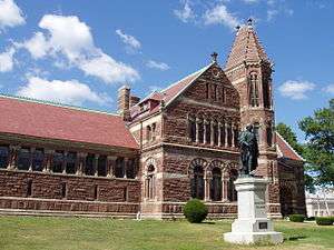
- Winn Memorial Library
- Woburn Memorial High School
- US Post Office, National Register-listed Classical Revival building
- First Congregational Church in Woburn, 1860 church belonging to a 1642 congregation
References
- ↑ "Population and Housing Unit Estimates". Archived from the original on May 29, 2017. Retrieved June 9, 2017.
- ↑ Johnson, Edward Francis, Captain Edward Johnson of Woburn, Massachusetts and Some of his Descendants, Press of David Clapp & Son, Boston, MA, 1905.
- ↑ Richardson, Doug. The English Origin and Ancestry of The Parker Brothers of Massachusetts and their Probable Aunt, Sarah Parker, Wife of Edward Converse. NEHGS Register, Vol. 153. January 1999, No. 609. See "Archived copy". Archived from the original on 2004-10-13. Retrieved 2007-05-21. . Accessed 20 May 2007.
- ↑ Thompson, Rev. Leander, "Deacon Edward Convers," Winchester Record, October, 1885 ("Archived copy". Archived from the original on 2012-11-03. Retrieved 2011-02-11. ) Retrieved 10 Feb. 2011.
- ↑ "Woburn Advocate - newspaper in Woburn, Massachusetts USA with local news and community events". www.mondotimes.com. Retrieved 2016-11-11.
- ↑ "Middlesex Court's move to Woburn to add hassle for commuters - The Boston Globe". archive.boston.com. Archived from the original on 2016-11-05. Retrieved 2016-11-11.
- ↑ "TradeCenter 128 named Project of the Year". Woburn Advocate. Archived from the original on 2016-11-05. Retrieved 2016-11-11.
- ↑ "Police Officer John B. Maguire". odmp.org. Archived from the original on 4 July 2013. Retrieved 30 April 2018.
- ↑ "Woburn joins elite biotech-zoning list - Boston Business Journal". Boston Business Journal. Archived from the original on 2016-11-05. Retrieved 2016-11-04.
- ↑ "Brief History". ce547.groups.et.byu.net. Archived from the original on 21 September 2011. Retrieved 30 April 2018.
- ↑ Long, Tom (11 May 2005). "Judge Walter Skinner, 77; oversaw Woburn-Grace case". The Boston Globe. Archived from the original on 23 April 2008.
- ↑ Harr, Jonathan (1996). A civil action. Vintage Books, New York, 502 p. ISBN 0-394-56349-2.
- ↑ "US Gazetteer files: 2010, 2000, and 1990". United States Census Bureau. 2011-02-12. Archived from the original on 2012-03-12. Retrieved 2011-04-23.
- ↑ "Total Population (P1), 2010 Census Summary File 1". American FactFinder, All County Subdivisions within Massachusetts. United States Census Bureau. 2010.
- ↑ "Massachusetts by Place and County Subdivision - GCT-T1. Population Estimates". United States Census Bureau. Retrieved July 12, 2011.
- ↑ "1990 Census of Population, General Population Characteristics: Massachusetts" (PDF). US Census Bureau. December 1990. Table 76: General Characteristics of Persons, Households, and Families: 1990. 1990 CP-1-23. Retrieved July 12, 2011.
- ↑ "1980 Census of the Population, Number of Inhabitants: Massachusetts" (PDF). US Census Bureau. December 1981. Table 4. Populations of County Subdivisions: 1960 to 1980. PC80-1-A23. Retrieved July 12, 2011.
- ↑ "1950 Census of Population" (PDF). Bureau of the Census. 1952. Section 6, Pages 21-10 and 21-11, Massachusetts Table 6. Population of Counties by Minor Civil Divisions: 1930 to 1950. Retrieved July 12, 2011.
- ↑ "1920 Census of Population" (PDF). Bureau of the Census. Number of Inhabitants, by Counties and Minor Civil Divisions. Pages 21-5 through 21-7. Massachusetts Table 2. Population of Counties by Minor Civil Divisions: 1920, 1910, and 1920. Retrieved July 12, 2011.
- ↑ "1890 Census of the Population" (PDF). Department of the Interior, Census Office. Pages 179 through 182. Massachusetts Table 5. Population of States and Territories by Minor Civil Divisions: 1880 and 1890. Retrieved July 12, 2011.
- ↑ "1870 Census of the Population" (PDF). Department of the Interior, Census Office. 1872. Pages 217 through 220. Table IX. Population of Minor Civil Divisions, &c. Massachusetts. Retrieved July 12, 2011.
- ↑ "1860 Census" (PDF). Department of the Interior, Census Office. 1864. Pages 220 through 226. State of Massachusetts Table No. 3. Populations of Cities, Towns, &c. Retrieved July 12, 2011.
- ↑ "1850 Census" (PDF). Department of the Interior, Census Office. 1854. Pages 338 through 393. Populations of Cities, Towns, &c. Retrieved July 12, 2011.
- ↑ "1950 Census of Population" (PDF). 1: Number of Inhabitants. Bureau of the Census. 1952. Section 6, Pages 21-7 through 21-09, Massachusetts Table 4. Population of Urban Places of 10,000 or more from Earliest Census to 1920. Archived (PDF) from the original on July 21, 2011. Retrieved July 12, 2011.
- ↑ "Census of Population and Housing". Census.gov. Archived from the original on May 12, 2015. Retrieved June 4, 2015.
- ↑ "American FactFinder". United States Census Bureau. Archived from the original on 2013-09-11. Retrieved 2008-01-31.
- ↑ WBA website "Archived copy". Archived from the original on 2012-02-22. Retrieved 2012-02-19.
- ↑ WRA at the City of Woburn website "Archived copy". Archived from the original on 2010-11-20. Retrieved 2012-02-19.
- ↑ "Largest 100 Employers in Woburn". detma.org. Archived from the original on 17 February 2015. Retrieved 30 April 2018.
Further reading
_map.jpg)
- Chronological History of Woburn.
- Ebenezer Locke Revolutionary War soldier from Woburn.
- 1871 Atlas of Massachusetts by Wall & Gray Map of Massachusetts. Map of Middlesex County
- History of Middlesex County, Massachusetts, Volume 1 (A-H), Volume 2 (L-W) compiled by Samuel Adams Drake, published 1879-1880. 572 and 505 pages. Woburn article by George M. Chamney in volume 2, pages 526-554.
- The History of Woburn, Middlesex County, Massachusetts, by Samuel Sewall, Charles Chauncy Sewall, Samuel Thompson; published 1868, 657 pages.
- Old USGS Maps of Woburn.
External links
| Wikimedia Commons has media related to Woburn, Massachusetts. |

- Woburn official website
- Woburn Public Schools website
- Woburn Residents' Environmental Network
- Woburn Historical Society Website
- A Guide to Woburn's Historical Organizations
- Count Rumford Museum Website
- Woburn Patriots Day Reenactment Website
- SCI Woburn Community Website
- Woburn Advocate (Newspaper)
- Woburn Daily Times Chronicle (Newspaper)
- Woburn Business Association
- Old USGS Maps of Woburn.
- Woburn Civil War Monument at the Massachusetts Civil War Monuments Project
Municipalities and communities of Middlesex County, Massachusetts, United States | ||
|---|---|---|
| Cities | 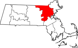 | |
| Towns |
| |
| CDPs | ||
| Other villages | ||
Boston (capital) | |
| Topics |
|
| Society | |
| Regions |
|
| Counties | |
| Cities |
|