Epping, New Hampshire
| Epping, New Hampshire | ||
|---|---|---|
| ||
|
Nickname(s): "Home of Three Governors" "The Center of the Universe" | ||
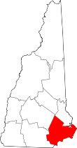
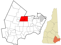 Location in Rockingham County and the state of New Hampshire. | ||
| Coordinates: 43°02′00″N 71°04′27″W / 43.03333°N 71.07417°WCoordinates: 43°02′00″N 71°04′27″W / 43.03333°N 71.07417°W | ||
| Country | United States | |
| State | New Hampshire | |
| County | Rockingham | |
| Incorporated | 1741 | |
| Villages |
Epping West Epping Camp Hedding | |
| Government | ||
| • Board of Selectmen |
Michael Yergeau Tom Dwyer Adam Munguia Cody Belanger Bob Jordan | |
| • Town Administrator | Greg Dodge | |
| Area | ||
| • Total | 26.2 sq mi (67.9 km2) | |
| • Land | 26.0 sq mi (67.4 km2) | |
| • Water | 0.2 sq mi (0.5 km2) | |
| Elevation | 157 ft (48 m) | |
| Population (2010) | ||
| • Total | 6,411 | |
| • Density | 240/sq mi (94/km2) | |
| Time zone | UTC-5 (EST) | |
| • Summer (DST) | UTC-4 (EDT) | |
| ZIP code | 03042 | |
| Area code(s) | 603 Exchange: 679 | |
| FIPS code | 33-24660 | |
| GNIS feature ID | 0873591 | |
| Website |
www | |
Epping is a town in Rockingham County, New Hampshire, United States. The population was 6,411 at the 2010 census.[1] Epping includes the area known as Camp Hedding.
The primary settlement in town, where 1,681 people resided at the 2010 census,[1] is defined by the U.S. Census Bureau as the Epping census-designated place (CDP) and includes the densely populated portion of the town centered on New Hampshire Route 27 just west of New Hampshire Route 125.
History
The town was originally part of Exeter, one of the four original New Hampshire townships. To encourage settlement, as early as 1710 Exeter awarded free wood lots in the area. In 1741, Epping was granted a charter and incorporated as a town, the last New Hampshire town chartered by Governor Jonathan Belcher before the Province of New Hampshire was granted a governor who did not also govern the neighboring Province of Massachusetts Bay. Epping was named for Epping in England.[2]
Following the American Revolution, many residents of the town moved to Monmouth, Maine, when General Henry Dearborn offered free land to his soldiers. Through the 1800s, farming was a principal occupation in Epping. The town also had substantial reserves of clay, long used by local residents to make bricks, and in 1840, the first commercial brickyard was established in Epping.
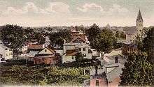
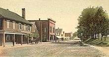
It was formerly said in jest: "Epping -- the center of the universe." Now, due to its strategic position at the crossroads of Route 101 and Route 125, the community is indeed becoming a retail center, as chain stores locate here. But because the traditional town center is clustered around Route 27, an older road connecting Exeter with Hooksett and Manchester, Epping's antique architectural charm has been spared from redevelopment.
Epping was once an important railroad crossroads for the Worcester, Nashua & Rochester Railroad and the Portsmouth & Concord Railroad, later both part of the Boston & Maine Railroad system. The north-south WN&R line through town was abandoned in 1932, with a short segment remaining in place south to Fremont to serve a brickyard there. This left the east-west Portsmouth Branch between Manchester and Portsmouth as the sole rail access to the outside world. Rail service on the Portsmouth Branch and the Fremont Branch ended in the early 1980s, the remaining track was abandoned by the Boston & Maine in 1982 and the rail was removed between 1983 and 1985. The railroad beds in town have been preserved as the Rockingham Recreational Trail. Abutments for the WN&R bridge over the Lamprey River can be seen along Route 125.
Culture
Epping is home to the Leddy Center, an antique playhouse where local performers present classics such as The Wizard of Oz and Anne of Green Gables. Musical lessons are also offered at this facility.
New England Dragway and Star Speedway are also located in Epping. New England Dragway puts on races and auto displays throughout the year, including the IHRA Amalie Oil North American Nationals and, since 2013, the NHRA New England Nationals. The dragway hosts a popular Halloween display during the second half of October.
An annual canoe race down the Lamprey River occurs on the last weekend in April, and the fire department arranges for Santa to drive through the town atop a fire engine during the winter.
Camp Hedding, the site of a United Methodist campground founded in 1862, is located in the eastern part of town. The ground now hosts an annual camp meeting for one week in August and an "olde time fair" on the first Saturday of August every year.
Epping has two annual parades, the memorial parade and the Christmas parade. The memorial parade usually includes youth sports teams, scouts, the combined middle and high school marching band, the fire department, police department, and veterans. The Christmas parade includes a few fire trucks and police cars that go around town with Santa and his elves throwing candy to kids who are outside.
Geography
According to the United States Census Bureau, the town has a total area of 26.2 square miles (68 km2), of which 26.0 square miles (67 km2) is land and 0.2 square miles (0.52 km2) is water, comprising 0.76% of the town. Epping is drained by the Lamprey and Piscassic rivers. The highest point in Epping is Kennard Hill at 472 feet (144 m) above sea level, located in the town's northwest corner. Epping lies fully within the Piscataqua River (Coastal) watershed.[3]
The town center, defined as a census-designated place (CDP), has a total area of 2.7 square miles (7.0 km2), all land.
Demographics
| Historical population | |||
|---|---|---|---|
| Census | Pop. | %± | |
| 1790 | 1,233 | — | |
| 1800 | 1,121 | −9.1% | |
| 1810 | 1,182 | 5.4% | |
| 1820 | 1,158 | −2.0% | |
| 1830 | 1,263 | 9.1% | |
| 1840 | 1,234 | −2.3% | |
| 1850 | 1,663 | 34.8% | |
| 1860 | 1,414 | −15.0% | |
| 1870 | 1,270 | −10.2% | |
| 1880 | 1,536 | 20.9% | |
| 1890 | 1,721 | 12.0% | |
| 1900 | 1,641 | −4.6% | |
| 1910 | 1,649 | 0.5% | |
| 1920 | 1,276 | −22.6% | |
| 1930 | 1,672 | 31.0% | |
| 1940 | 1,618 | −3.2% | |
| 1950 | 1,796 | 11.0% | |
| 1960 | 2,006 | 11.7% | |
| 1970 | 2,356 | 17.4% | |
| 1980 | 3,460 | 46.9% | |
| 1990 | 5,549 | 60.4% | |
| 2000 | 5,476 | −1.3% | |
| 2010 | 6,411 | 17.1% | |
| Est. 2015 | 6,835 | [4] | 6.6% |
| U.S. Decennial Census[5] | |||
As of the census of 2010, there were 6,411 people, 2,466 households, and 1,768 families residing in the town. There were 2,723 housing units, of which 257, or 9.4%, were vacant. The racial makeup of the town was 96.2% white, 0.3% African American, 0.2% Native American, 1.3% Asian, 0.03% Native Hawaiian or Pacific Islander, 0.3% some other race, and 1.6% from two or more races. 1.6% of the population were Hispanic or Latino of any race.[6]
Of the 2,466 households, 34.4% had children under the age of 18 living with them, 57.5% were headed by married couples living together, 9.0% had a female householder with no husband present, and 28.3% were non-families. 20.3% of all households were made up of individuals, and 6.5% were someone living alone who was 65 years of age or older. The average household size was 2.60, and the average family size was 2.99.[6]
In the town, 22.8% of the population were under the age of 18, 7.6% were from 18 to 24, 28.6% from 25 to 44, 30.5% from 45 to 64, and 10.5% were 65 years of age or older. The median age was 40.0 years. For every 100 females, there were 96.8 males. For every 100 females age 18 and over, there were 94.2 males.[6]
For the period 2011-2015, the estimated median annual income for a household was $77,750, and the median income for a family was $86,886. Male full-time workers had a median income of $66,330 versus $47,538 for females. The per capita income for the town was $34,982. 6.3% of the population and 3.3% of families were below the poverty line. 12.1% of the population under the age of 18 and 1.5% of those 65 or older were living in poverty.[7]
Sites of interest
Notable people
- Kerry Bascom, forward and coach with the University of Connecticut women's basketball team
- Carl Stearns Clancy, first person to circumnavigate the globe on a motorcycle
- Sheila LaBarre, convicted murderer
- David L. Morril, US senator; 16th governor of New Hampshire (1824–1827)
- B. G. Plumer, Wisconsin politician and businessman
- Daniel L. Plumer, Wisconsin politician and businessman
- William Plumer, US senator; 11th and 13th governor of New Hampshire (1812–1813 / 1816–1819)
- Benjamin Franklin Prescott, 36th governor of New Hampshire (1877–1879)
References
- 1 2 United States Census Bureau, American FactFinder, 2010 Census figures. Retrieved March 23, 2011.
- ↑ Gannett, Henry (1905). The Origin of Certain Place Names in the United States. Govt. Print. Off. p. 120.
- ↑ Foster, Debra H.; Batorfalvy, Tatianna N.; Medalie, Laura (1995). Water Use in New Hampshire: An Activities Guide for Teachers. U.S. Department of the Interior and U.S. Geological Survey.
- ↑ "Annual Estimates of the Resident Population for Incorporated Places: April 1, 2010 to July 1, 2015". Retrieved July 2, 2016.
- ↑ "Census of Population and Housing". Census.gov. Archived from the original on May 12, 2015. Retrieved June 4, 2016.
- 1 2 3 "Profile of General Population and Housing Characteristics: 2010 Census Summary File 1 (DP-1): Epping town, Rockingham County, New Hampshire". American Factfinder. U.S. Census Bureau. Retrieved November 7, 2017.
- ↑ "Selected Economic Characteristics: 2011-2015 American Community Survey 5-Year Estimates (DP03): Epping town, Rockingham County, New Hampshire". American Factfinder. U.S. Census Bureau. Retrieved November 7, 2017.
External links
- Town of Epping official website
- Harvey-Mitchell Memorial Library
- New Hampshire Economic and Labor Market Information Bureau Profile
Places adjacent to Epping, New Hampshire | |
|---|---|