Lebanon, New Hampshire
| Lebanon, New Hampshire | ||
|---|---|---|
| City | ||
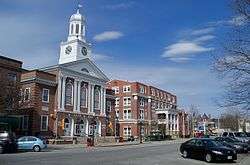 Buildings along Park Street in downtown Lebanon | ||
| ||
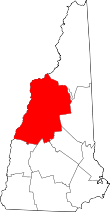
 Location in Grafton County, New Hampshire | ||
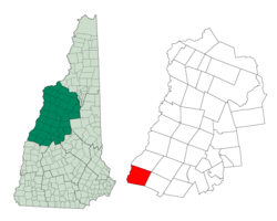
 Lebanon Location in USA | ||
| Coordinates: 43°38′32″N 72°15′06″W / 43.64222°N 72.25167°WCoordinates: 43°38′32″N 72°15′06″W / 43.64222°N 72.25167°W | ||
| Country | United States | |
| State | New Hampshire | |
| County | Grafton | |
| Incorporated | 1761 | |
| City | 1958 | |
| Population centers |
Lebanon East Wilder Mascoma West Lebanon | |
| Government | ||
| • Mayor | Suzanne M. Prentiss | |
| • Assistant Mayor | Timothy J. McNamara | |
| • City Council |
Members
| |
| • City Manager | Shaun Mulholland | |
| Area | ||
| • Total | 41.4 sq mi (107.1 km2) | |
| • Land | 40.3 sq mi (104.5 km2) | |
| • Water | 1.0 sq mi (2.6 km2) 2.39% | |
| Elevation | 581 ft (177 m) | |
| Population (2010) | ||
| • Total | 13,151 | |
| • Estimate (2016)[1] | 13,513 | |
| • Density | 335/sq mi (129.4/km2) | |
| Time zone | UTC-5 (Eastern) | |
| • Summer (DST) | UTC-4 (Eastern) | |
| ZIP codes | 03756, 03766, 03784 | |
| Area code(s) | 603 | |
| FIPS code | 33-41300 | |
| GNIS feature ID | 0867976 | |
| Website |
lebanonnh | |

Lebanon locally /ˈlɛbənən/ is a city in Grafton County, New Hampshire, United States. The population was 13,151 at the 2010 census[2] and an estimated 13,513 as of 2016.[1] Lebanon is located in western New Hampshire, south of Hanover, near the Connecticut River. It is the home to Dartmouth-Hitchcock Medical Center and Dartmouth Medical School, together comprising the largest medical facility between Boston, Massachusetts and Burlington, Vermont.
Together with Hanover, New Hampshire, and White River Junction, Vermont, Lebanon today is at the center of a Micropolitan Statistical Area, encompassing nearly 30 towns along the upper Connecticut River valley.
History
Lebanon was chartered as a town by Colonial Governor Benning Wentworth on July 4, 1761, one of 16 along the Connecticut River. It was named for Lebanon, Connecticut, from where many early settlers had come or would come, including the Rev. Eleazar Wheelock, who arrived in 1770 and founded Dartmouth College. Lebanon, Connecticut was the original home of Moor's Indian Charity School, the antecedent of Dartmouth College.
Early settlement concentrated along the Connecticut River in what is now West Lebanon, and along the Mascoma Lake region near Enfield. In the mid-19th century, a mill district developed at falls on the Mascoma River. Industries included, at various times, furniture mills, a tannery, several machine shops, a woolen textile mill and a clothing factory. In the mid-19th century, this district attracted many French workers from Canada's Quebec province. This became the center of town, although West Lebanon grew into a railroad hub with a separate identity after lines entered from Boston. This rail center would become known as Westboro after two trains collided when West Lebanon was mistaken for Lebanon.
The mill district, like the railroad, declined into the 1950s and 1960s. The town suffered two major fires; the second, in 1964, destroyed a large portion of the old mill district. Reconstruction resulted in a controversial urban renewal project featuring a closed-off district, called The Mall, built to replace the destroyed Hanover Street area. Partly in defiance of economic decline, and partly to counter a movement by West Lebanon to declare itself an independent town, Lebanon re-incorporated as a city in 1958.
The routing of Interstates 89 and 91 through Lebanon and nearby White River Junction, Vermont, in addition to the growth of Dartmouth College, led to the area's economic revival. The former mill town now has a mixed economy based on education, medical services, high-technology and retail. Just south of the village of West Lebanon, a major shopping district has sprung up at the intersection of Route 12A and I-89. Lebanon has undertaken improvements to its recreational facilities, including miles of hiking trails, a municipal ski area, a swimming pool and several sports fields.
In 1991, the Dartmouth-Hitchcock Medical Center, along with most departments of Dartmouth Medical School, moved from Hanover to a new campus just south of the Lebanon-Hanover town line. A number of medical and high-tech firms have located facilities near the medical center campus. Tele Atlas, a leading worldwide developer of mapping databases, has its North American headquarters in Lebanon. Novell and Microsoft also have major facilities here, as well as Novo Nordisk.
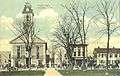 Old Town Hall in 1918
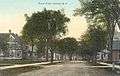 School Street c. 1910
 Public Library c. 1910
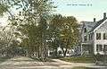 Bank Street c. 1910
Geography
Lebanon is located at 43°38′38″N 72°15′19″W / 43.64389°N 72.25528°W (43.643897, -72.255242).[3]
According to the United States Census Bureau, the city has a total area of 41.4 square miles (107.1 km2), of which 40.3 square miles (104.4 km2) is land and 1.0 square mile (2.6 km2) is water, comprising 2.45% of the city.[2] The western boundary of Lebanon is the Connecticut River, which is also the state boundary with Vermont. The village of West Lebanon occupies the western part of the city, along the Connecticut River. Downtown Lebanon is 3 miles (5 km) to the east, along the Mascoma River, a tributary of the Connecticut. The city is fully within the Connecticut River watershed.[4] The southern end of Moose Mountain is in the northeast. The highest point in Lebanon is the northern end of Shaker Mountain, at 1,657 feet (505 m) above sea level, on the eastern border of the city.
Demographics
| Historical population | |||
|---|---|---|---|
| Census | Pop. | %± | |
| 1790 | 1,180 | — | |
| 1800 | 1,574 | 33.4% | |
| 1810 | 1,808 | 14.9% | |
| 1820 | 1,710 | −5.4% | |
| 1830 | 1,868 | 9.2% | |
| 1840 | 1,754 | −6.1% | |
| 1850 | 2,127 | 21.3% | |
| 1860 | 2,322 | 9.2% | |
| 1870 | 3,094 | 33.2% | |
| 1880 | 3,354 | 8.4% | |
| 1890 | 3,703 | 10.4% | |
| 1900 | 4,965 | 34.1% | |
| 1910 | 5,718 | 15.2% | |
| 1920 | 6,162 | 7.8% | |
| 1930 | 7,073 | 14.8% | |
| 1940 | 7,590 | 7.3% | |
| 1950 | 8,495 | 11.9% | |
| 1960 | 9,299 | 9.5% | |
| 1970 | 9,725 | 4.6% | |
| 1980 | 11,134 | 14.5% | |
| 1990 | 12,183 | 9.4% | |
| 2000 | 12,568 | 3.2% | |
| 2010 | 13,151 | 4.6% | |
| Est. 2016 | 13,513 | [1] | 2.8% |
| U.S. Decennial Census[5] | |||

As of the census of 2010,[6] there were 13,151 people, 6,186 households, and 3,269 families residing in the city. The population density was 326.2 people per square mile (125.9/km²). There were 6,649 housing units at an average density of 164.9 per square mile (63.7/km²). The racial makeup of the city was 88.4% White, 1.6% African American, 0.30% Native American, 6.8% Asian, 0.00% Pacific Islander, 0.80% some other race, and 2.10% from two or more races. Hispanic or Latino of any race were 2.9% of the population.
There were 6,186 households out of which 24.2% had children under the age of 18 living with them, 40.5% were married couples living together, 8.9% had a female householder with no husband present, 3.4% had a male householder with no wife present, and 47.2% were non-families. 36.8% of all households were made up of individuals, and 12.4% were someone living alone who was 65 years of age or older. The average household size was 2.10, and the average family size was 2.76.[6]
In the city, the population was spread out with 20.5% from age 0-19, 6.3% from 20 to 24, 30.3% from 25 to 44, 27.6% from 45 to 64, and 15.3% who were 65 years of age or older. The median age was 39.4 years. The male population was 47.4% of the total, while the female population was 52.6%.[6]
For the period 2011-15, the estimated median annual income for a household in the city was $53,004, and the median income for a family was $75,511. Male full-time workers had a median income of $51,735 versus $48,836 for females. The per capita income for the city was $36,370. About 8.7% of families and 12.3% of the entire population were below the poverty line, including 22.6% of those under 18 and 5.0% of those age 65 and over.[7]
Education
Lebanon has its own elementary schools, junior high school, and high school. Students from neighboring towns (Grantham and Plainfield[8]) attend high school in Lebanon. On October 15, 2010, the city broke ground on a new middle school for grades 5-8 to replace an aging junior high facility and overcrowded elementary school facilities.[9] As of April 2012, the Middle School was "nearing completion", and the project is being finalized, with minor projects left, including "adding pavement..., resurfacing, and striping to allow turning lanes for the school traffic."[10]
Located on the downtown pedestrian mall is the Lebanon campus of Claremont-based River Valley Community College. Also downtown, the Alliance for the Visual Arts (AVA) offers classes in arts and crafts in a LEED-certified former factory building, which houses a ground floor gallery space.
Transportation
Roads and highways
Lebanon is served by Interstate 89, which meets Interstate 91 just across the Connecticut River in White River Junction. It is 58 miles (93 km) southeast along I-89 to Concord, the state capital, and 60 miles (97 km) northwest along I-89 to Montpelier, the capital of Vermont. U.S. Route 4 passes east–west through the centers of Lebanon and West Lebanon, leading east to Enfield and eventually Concord, and west towards Rutland, Vermont. New Hampshire Route 10 leads south from Lebanon along Interstate 89, eventually diverging to go to Newport. Route 10 leads north from West Lebanon into Hanover and points north along the Connecticut River. New Hampshire Route 120 passes north–south through downtown Lebanon, leading north into Hanover and south to Claremont. New Hampshire Route 12A begins in West Lebanon and heads south along the Connecticut River to Claremont. Near the eastern border of the city, New Hampshire Route 4A leaves US 4 to travel southeast towards Wilmot and central New Hampshire.
Public transportation
Lebanon Airport, adjacent to West Lebanon, has passenger service to Boston and New York City provided by Cape Air. Free public bus service for the major towns in the area including Lebanon is provided by Advance Transit, with weekday service to destinations such as Dartmouth–Hitchcock Medical Center, shopping plazas in West Lebanon, the villages of Lebanon and West Lebanon, as well as Hanover and White River Junction. Southeast Vermont Transit also provides a peak direction commuter bus route between DHMC to Bellows Falls, Vermont that also runs on weekdays.
The closest Greyhound bus terminal and Amtrak train station are both located in White River Junction, Vermont. Vermont Translines also serves Lebanon from the Dartmouth-Hitchcock Medical Center.[11][12][13]
Culture
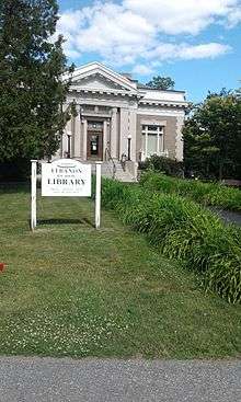
Lebanon village is a cultural hub with attractions such as the Lebanon Opera House (in City Hall), the AVA Gallery, seasonal Farmers' Market and summer concerts on the green. Lebanon Public Library serves the main village, and the newly opened Kilton Public Library branch (the first library in the U.S. to host a node of the Tor anonymity network)[14] serves West Lebanon village. The Carter Community Building Association (CCBA) operates an after-school activity center for primary school children and a fitness center for teens and adults. Salt Hill Pub frequently features live musical performances.
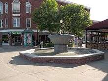
Colburn Park
The Colburn Park Historic District is at the heart of Lebanon, New Hampshire, consisting of Colburn Park and buildings around it—and many 19th-century buildings immediately adjacent to these. The district was listed on the National Register of Historic Places in 1986. The land that later developed into the park was donated in 1792 by Robert Colburn as the site for the community's meeting house, serving the purposes of church and town hall. Arterial roads were built to the area, and it began to develop as a commercial and civic center in the early 19th century. A weekly farmers' market is held there between June and September along with many community activities throughout the year.
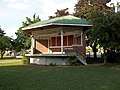 Stage
Stage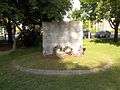 War memorial
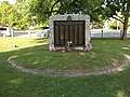 War memorial
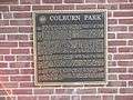 Plaque
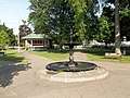 Fountain
Notable people
- Nick Alexander, 2010 and 2014 US Olympic Team ski jumper[15]
- Aaron Baddeley, golfer with the PGA Tour
- Minnie Willis Baines Miller, author
- Duane R. Bushey, naval officer
- Thomas C. Chalmers, physician and researcher
- Harry Morrison Cheney, Speaker of New Hampshire House of Representatives
- Norris Cotton, US senator
- Aaron H. Cragin, politician
- Lane Dwinell, manufacturer
- Experience Estabrook, lawyer and politician
- Phineas Gage, railroad foreman and brain-injury survivor
- Charley Parkhurst, stagecoach driver
- George Halsey Perley, politician and diplomat
- Phineas Quimby, philosopher
- Hezekiah Bradley Smith, inventor
- Joseph Smith, founder of the Latter Day Saint movement[16]
- George Storrs, writer who influenced many Christian denominations, including Seventh-day Adventists and Bible Students (later Jehovah's Witnesses)[17]
- Sarah Strohmeyer, author
- William Ticknor, publisher
- Mia Tyler, model and actress
- Rob Woodward, pitcher with the Boston Red Sox and radio host
- Ammi B. Young, architect
References
- 1 2 3 "Population and Housing Unit Estimates". Retrieved June 9, 2017.
- 1 2 "Geographic Identifiers: 2010 Demographic Profile Data (G001): Lebanon city, New Hampshire". U.S. Census Bureau, American Factfinder. Retrieved January 3, 2017.
- ↑ "US Gazetteer files: 2010, 2000, and 1990". United States Census Bureau. 2011-02-12. Retrieved 2011-04-23.
- ↑ Foster, Debra H.; Batorfalvy, Tatianna N.; Medalie, Laura (1995). Water Use in New Hampshire: An Activities Guide for Teachers. U.S. Department of the Interior and U.S. Geological Survey.
- ↑ "Census of Population and Housing". Census.gov. Retrieved June 4, 2015.
- 1 2 3 "Profile of General Population and Housing Characteristics: 2010 Census Summary File 1 (DP-1): Lebanon city, New Hampshire". U.S. Census Bureau, American Factfinder. Retrieved January 3, 2017.
- ↑ "Selected Economic Characteristics: 2011-2015 American Community Survey 5-Year Estimates (DP03): Lebanon city, New Hampshire". U.S. Census Bureau, American Factfinder. Retrieved January 3, 2017.
- ↑ "Lebanon School District Information". Lebanon School District. Archived from the original on May 14, 2011. Retrieved September 4, 2009.
- ↑ "Lebanon Middle School Project". Lebanon School District. Archived from the original on September 18, 2010. Retrieved October 25, 2010.
- ↑ "Lebanon Middle School Project". Lebanon School District. Archived from the original on March 14, 2012. Retrieved May 27, 2012.
- ↑ Stations - White River Junction (WRJ), Amtrak. Retrieved 2017-07-17.
- ↑ White River Jct Vermont Bus Station, Greyhound. Retrieved 2017-07-17.
- ↑ "Vermont Bus Schedules Vermont Translines". Retrieved 2017-07-17.
- ↑ "Archived copy". Archived from the original on 2015-09-18. Retrieved 2015-11-20.
- ↑ "Olympic Ski Jumping Team Named". US Ski Team. 20 January 2010. Archived from the original on 1 September 2010. Retrieved 21 January 2010.
- ↑ Teaching of Presidents of the Church, Church of Jesus Christ of Latter Day Saints, 2007, Salt Lake City, Utah
- ↑ Penton, James M. Apocalypse Delayed: The Story of Jehovah's Witnesses Univ. of Toronto Press: Toronto, Canada 1985
External links
- City of Lebanon official website
- Colburn Park Historic District
- Lebanon Historical Society
- Lebanon Opera House
- Lebanon Public Libraries
- Lebanon School District
- New Hampshire Economic and Labor Market Information Bureau Profile
Places adjacent to Lebanon, New Hampshire | |
|---|---|