Groton, Massachusetts
| Groton, Massachusetts | ||
|---|---|---|
| Town | ||
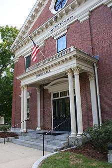 Town Hall | ||
| ||
| Motto(s): "Faith, Labor" | ||
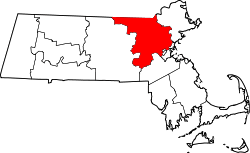
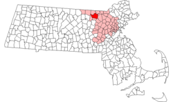 Location in Middlesex County in Massachusetts | ||
| Coordinates: 42°36′40″N 71°34′30″W / 42.61111°N 71.57500°WCoordinates: 42°36′40″N 71°34′30″W / 42.61111°N 71.57500°W | ||
| Country | United States | |
| State | Massachusetts | |
| County | Middlesex | |
| Settled | 1655 | |
| Incorporated | 1655 | |
| Government | ||
| • Type | Open town meeting | |
| • Administrative Officer | Jean E. Kitchen[1] | |
| • Board of Selectmen |
George F. Dillon, Jr.[2] Peter S. Cunningham John L. Saball Mihran Keoseian, Jr. 1 Vacancy | |
| Area | ||
| • Total | 33.7 sq mi (87.3 km2) | |
| • Land | 32.8 sq mi (84.9 km2) | |
| • Water | 0.9 sq mi (2.4 km2) | |
| Elevation | 320 ft (98 m) | |
| Population (2010) | ||
| • Total | 10,646 | |
| • Density | 320/sq mi (120/km2) | |
| Time zone | UTC−5 (Eastern) | |
| • Summer (DST) | UTC−4 (Eastern) | |
| ZIP Code | 01450 | |
| Area code(s) | (978 Exchanges: 448, 449) | |
| FIPS code | 25-27480 | |
| GNIS feature ID | 0619399 | |
| Website |
www | |

Groton is a town in northwestern Middlesex County, Massachusetts, United States, within the Greater Boston metropolitan area. The population was 10,873 at the 2012 town census.[3] It is home to two prep schools: Groton School, founded in 1884,[4][5] and Lawrence Academy at Groton, founded in 1792 and the third-oldest private school in Massachusetts. Lawrence Academy was founded with a charter from John Hancock.[6]
Near the former border with Maine, the historic town was a battlefield in King Philip's War[7] and Queen Anne's War, with children taken captive in a raid by Abenaki and French;[7] it had had incidents of insurrection during Shays' Rebellion,[8] and was the birthplace of William Prescott, who commanded the colonial forces at the Battle of Bunker Hill during the American Revolution.[9]
History
The area surrounding modern-day Groton has, for thousands of years, been the territory of various cultures of indigenous peoples. They settled along the rivers, which they used for domestic tasks, fishing and transportation. Historic tribes were the Algonquian-speaking Nipmuc and Nashaway Indians.[10]
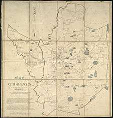
.jpg)
The Anglo-American Groton started with the trading post of John Tinker, who conducted business there with the Nashaway at the confluence of Nod Brook and the Nashua River. The Nashaway called the area Petapawag, meaning "swampy land." As Tinker had, other pioneers followed the Algonquian trails from Massachusetts Bay. They found the region productive for fishing and farming.[10]
The town was officially settled and incorporated in 1655, named for Groton in Suffolk, England. Called The Plantation of Groton, it included all of present-day Groton and Ayer, almost all of Pepperell and Shirley, large parts of Dunstable, Littleton, and Tyngsborough, plus smaller parts of Harvard and Westford in Massachusetts, as well as Nashua and Hollis, New Hampshire.[10]
During King Philip's War, on March 13, 1676, Indians burned all buildings except for four Groton garrisons. Among those killed was John Nutting, a Selectman at Groton. Survivors fled to Concord and other safe havens, but two years later returned to rebuild.[10] Native Americans attacked the town again during the Raid on Groton in 1694 (during King William's War).
In 1704 during Queen Anne's War, a French-Abenaki raid captured three children of Thomas Tarbell and his wife, among others, taking them overland about 300 miles to the Mohawk village of Kahnewake south of Montreal, where they would be held for ransom or adopted into the tribe by individual Mohawk families. The trade in captives was a thriving business between the opposing colonies of the English and French. The two Tarbell boys, John and Zachariah, were adopted by Mohawk families and became fully assimilated, later marrying into the tribe, having families, and becoming chiefs.[11] They were among the founders in the 1740s of Akwesasne, after moving up the St. Lawrence River from Kahnewake. The brothers' older sister Sarah Tarbell was ransomed by a French family, and converted to Catholicism. She joined a Catholic teaching/nursing religious order in Montreal and served with them for the rest of her life.[11][12][13] There are Tarbell-named descendants among Mohawk of Kahnewake and Akwesasne in the 21st century.
In 1775, the common in front of the First Parish Church was an assembly area for Minutemen who fought in the Battle of Lexington and Concord.[10]
Geography
According to the United States Census Bureau, Groton has a total area of 33.7 square miles (87.3 km²), of which 32.8 square miles (84.9 km²) is land and 0.9 square miles (2.4 km²) (2.79%) is water. Groton is the largest town in Middlesex County in terms of square mileage. The town is drained by the Nashua River and Squannacook River. The center of the town is dominated mainly by Gibbet Hill, with several other large hills throughout the town.
Groton is served by state routes 40, 111, 119 and 225. It borders the towns of Pepperell, Dunstable, Tyngsborough, Westford, Littleton, Ayer, Shirley, and Townsend.
Demographics
See also: Groton (CDP), Massachusetts
| Historical population | ||
|---|---|---|
| Year | Pop. | ±% |
| 1676 | 300 | — |
| 1765 | 1,408 | +369.3% |
| 1776 | 1,639 | +16.4% |
| 1790 | 1,840 | +12.3% |
| 1800 | 1,802 | −2.1% |
| 1810 | 1,886 | +4.7% |
| 1820 | 1,897 | +0.6% |
| 1830 | 1,925 | +1.5% |
| 1840 | 2,139 | +11.1% |
| 1850 | 2,515 | +17.6% |
| 1860 | 3,193 | +27.0% |
| 1870 | 3,584 | +12.2% |
| 1880 | 1,862 | −48.0% |
| 1890 | 2,057 | +10.5% |
| 1900 | 2,052 | −0.2% |
| 1910 | 2,155 | +5.0% |
| 1920 | 2,185 | +1.4% |
| 1930 | 2,434 | +11.4% |
| 1940 | 2,550 | +4.8% |
| 1950 | 2,889 | +13.3% |
| 1960 | 3,904 | +35.1% |
| 1970 | 5,109 | +30.9% |
| 1980 | 6,154 | +20.5% |
| 1990 | 7,511 | +22.1% |
| 2000 | 9,547 | +27.1% |
| 2010 | 10,646 | +11.5% |
| * = population estimate. Source: United States Census records and Population Estimates Program data.[14][15][16][17][18][19][20][21][22][23] | ||
As of the census[24] of 2000, there were 9,547 people, 3,268 households, and 2,568 families residing in the town. The population density was 291.3 people per square mile (112.5/km²). There were 3,393 housing units at an average density of 103.5 per square mile (40.0/km²). The racial makeup of the town was 97.22% White, 0.35% Black or African American, 0.13% Native American, 0.97% Asian, 0.02% Pacific Islander, 0.27% from other races, and 1.04% from two or more races. Hispanic or Latino of any race were 1.14% of the population.
There were 3,268 households out of which 46.8% had children under the age of 18 living with them, 70.0% were married couples living together, 6.3% had a female householder with no husband present, and 21.4% were non-families. Of all households 17.1% were made up of individuals and 5.4% had someone living alone who was 65 years of age or older. The average household size was 2.90 and the average family size was 3.31.
The age distribution of the town's population was 32.6% under the age of 18, 4.2% from 18 to 24, 32.7% from 25 to 44, 23.5% from 45 to 64, and 7.0% who were 65 years of age or older. The median age was 36 years. For every 100 females, there were 98.2 males. For every 100 females age 18 and over, there were 94.5 males.
The median income for a household in the town was $118,041, and the median income for a family was $136,653. Males had a median income of $101,117 versus $60,402 for females. The per capita income for the town was $44,756. About 1.1% of families and 1.8% of the population were below the poverty line, including 1.0% of those under age 18 and none of those age 65 or over.[25]
Sports
Groton annually hosts the National Shepley Hill Horse Trials, an equestrian competition. The Groton-Dunstable Crusaders high school football team also competes in the town.
Government
The town is governed by an open Town Meeting and administered by an elected Board of Selectmen and appointed Town Manager.[26]
| Voter Registration and Party Enrollment as of February 15, 2012[27] | |||||
|---|---|---|---|---|---|
| Party | Number of Voters | Percentage | |||
| Democratic | 1,659 | 22.30% | |||
| Republican | 1,239 | 16.66% | |||
| Unaffiliated | 4,508 | 60.60% | |||
| Green-Rainbow | 4 | 0.05% | |||
| Total | 7,439 | 100% | |||
Education
Public schools
District schools
- Boutwell School
- Florence Roche Elementary School
- Groton-Dunstable Regional Middle School
- Groton-Dunstable Regional High School
- Prescott Elementary School (closed after the 2007–2008 school year due to budget cuts)[28]
Other public schools
- Nashoba Valley Technical High School, Public Regional Vocational Technical High School located in Westford
Private schools
- Groton Community School
- Country Day School of the Holy Union (Founded 1949 - Closed 2017)[29]
- Lawrence Academy (Founded 1793 as Groton Academy)
- Groton School (Founded 1884)
- Lowthorpe School of Landscape Architecture (Founded 1901, merged with Rhode Island School of Design in 1945)[30]
Points of interest
- Groton Historical Society & Museum[31]
- Gibbet Hill Castle
- Kalliroscope Gallery
- Autumn Hills Orchard
- Grotonwood Camp and Conference Center[32]
- The Old Groton Inn[33]
- Groton Public Library[34]
- Groton School
- Lawrence Academy
Buildings and structures
- Gov. George S. Boutwell House
- Indian Hill House
- Groton Inn, burned down on the night of August 2, 2011[35], rebuilding effort scheduled to be completed Spring 2018 [36]
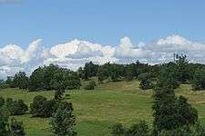
Conservation land
Over 30% of the land in Groton, Massachusetts is protected open space.[37] The majority of this open space is accessible to the public. Groton also has over 100 miles of trails. Many of these trails can be walked and biked, others are availably for hunting and/or camping. The trails are made and maintained by the Groton Trail Committee and the land itself is managed by the Groton Conservation Trust.
Notable people
- Andy Anderson, US National Team and Groton School Rowing Coach[38] and member of the National Rowing Hall of Fame.[39]
- Charles William Bardeen, educator and publisher[40]
- Shabazz Napier, basketball player
- John P. Bigelow, mayor of Boston
- Timothy Bigelow, lawyer, and father of John
- George Sewall Boutwell, governor and statesman
- Samuel Dana, clergyman
- Samuel Dana, congressman
- Margaret Fuller, journalist, critic and women's rights activist
- Timothy Fuller, U.S. Congressman, and father of Margaret
- Peter Gammons, sports writer and analyst
- J. Geils, founder of The J. Geils Band
- Samuel Abbott Green, physician and mayor of Boston
- Peter, Sue Kim, and Christine Hanson, killed on board United Airlines Flight 175 on September 11, 2001 (the latter was the youngest victim of the attacks, at just 2 1/2 years old)
- Kevin Kastning, musician, composer and musical instrument inventor
- Elizabeth Knapp, the Witch of Groton
- Steve Kornacki, political writer and TV host
- Abbott Lawrence, businessman, founder of Lawrence
- Amos Lawrence, merchant and philanthropist
- Amos Adams Lawrence, abolitionist and college founder
- John Lawrence (1609–1667) early settler Watertown, Mass. in 1630 then moved to Groton, Mass. in 1662 where he was a Selectman
- Samuel Lawrence, revolutionary and school founder
- Barzillai Lew, soldier, fifer and drummer
- Lydia Longley, "The First American Nun"
- Paul Matisse, artist and inventor
- Shelley Olds, professional cyclist who represented the United States in the 2012 Summer Olympics[41]
- Edward Saxton Payson, Esperantist, writer and translator
- Otto Piene, German artist
- Oliver Prescott, Massachusetts general, physician and judge
- William Prescott, revolutionary soldier
- William M. Richardson, U.S. Congressman
- Job Shattuck, soldier, Shays' Rebellion agitator
- Dan Shaughnessy, Boston sports columnist
- Ether Shepley, US Senator from Maine
- Lucius Edwin Smith, pastor of the Baptist church in Groton 1858–1865
- Charles Warren Stone, US Congressman
- Edmund C. Tarbell, artist, American Impressionist
- Frank Bigelow Tarbell, professor and author
- Samuel Willard, colonial minister
- Simon Willard, colonist, father of Samuel
References
- ↑ Archived September 14, 2003, at the Wayback Machine.
- ↑ Archived April 14, 2006, at the Wayback Machine.
- ↑ "Profile of General Population and Housing Characteristics: 2010 Demographic Profile Data (DP-1): Groton town, Middlesex County, Massachusetts". U.S. Census Bureau, American Factfinder. Archived from the original on September 11, 2013. Retrieved April 6, 2012.
- ↑ Laneri, Raquel. "Best Prep Schools 2010". Forbes. Retrieved 18 November 2014.
- ↑ "Groton.org". Groton.org. Retrieved 18 November 2014.
- ↑ "A Brief History of Lawrence Academy". LAcademy.edu. Retrieved 18 November 2014.
- 1 2 "A Brief History of Groton, MA". TownofGroton.org. Retrieved 18 November 2014.
- ↑ Szatmary, David. Shays' Rebellion: The Making of an Agrarian Insurrection (Reprint ed.). University of Massachusetts Press. p. 43. ISBN 978-0870234194.
- ↑ "William Prescott". theamericanrevolution.org. Retrieved 18 November 2014.
- 1 2 3 4 5 "Town of Groton, Massachusetts". Retrieved May 30, 2006.
- 1 2 John Demos, The Unredeemed Captive: A Family Story from Early America, New York: Alfred A. Knopf, 1994, pp. 186 and 224
- ↑ Darren Bonaparte, "The History of Akwesasne", The Wampum Chronicles, accessed 1 Feb 2010
- ↑ Darren Bonaparte, "First Families of Akwesasne", The Wampum Chronicles, accessed 21 Feb 2010
- ↑ "Total Population (P1), 2010 Census Summary File 1". American FactFinder, All County Subdivisions within Massachusetts. United States Census Bureau. 2010.
- ↑ "Massachusetts by Place and County Subdivision - GCT-T1. Population Estimates". United States Census Bureau. Retrieved July 12, 2011.
- ↑ "1990 Census of Population, General Population Characteristics: Massachusetts" (PDF). US Census Bureau. December 1990. Table 76: General Characteristics of Persons, Households, and Families: 1990. 1990 CP-1-23. Retrieved July 12, 2011.
- ↑ "1980 Census of the Population, Number of Inhabitants: Massachusetts" (PDF). US Census Bureau. December 1981. Table 4. Populations of County Subdivisions: 1960 to 1980. PC80-1-A23. Retrieved July 12, 2011.
- ↑ "1950 Census of Population" (PDF). Bureau of the Census. 1952. Section 6, Pages 21-10 and 21-11, Massachusetts Table 6. Population of Counties by Minor Civil Divisions: 1930 to 1950. Retrieved July 12, 2011.
- ↑ "1920 Census of Population" (PDF). Bureau of the Census. Number of Inhabitants, by Counties and Minor Civil Divisions. Pages 21-5 through 21-7. Massachusetts Table 2. Population of Counties by Minor Civil Divisions: 1920, 1910, and 1920. Retrieved July 12, 2011.
- ↑ "1890 Census of the Population" (PDF). Department of the Interior, Census Office. Pages 179 through 182. Massachusetts Table 5. Population of States and Territories by Minor Civil Divisions: 1880 and 1890. Retrieved July 12, 2011.
- ↑ "1870 Census of the Population" (PDF). Department of the Interior, Census Office. 1872. Pages 217 through 220. Table IX. Population of Minor Civil Divisions, &c. Massachusetts. Retrieved July 12, 2011.
- ↑ "1860 Census" (PDF). Department of the Interior, Census Office. 1864. Pages 220 through 226. State of Massachusetts Table No. 3. Populations of Cities, Towns, &c. Retrieved July 12, 2011.
- ↑ "1850 Census" (PDF). Department of the Interior, Census Office. 1854. Pages 338 through 393. Populations of Cities, Towns, &c. Retrieved July 12, 2011.
- ↑ "American FactFinder". United States Census Bureau. Archived from the original on 2013-09-11. Retrieved 2008-01-31.
- ↑ Archived April 28, 2011, at the Wayback Machine.
- ↑ About Groton
- ↑ "Registration and Party Enrollment Statistics as of February 15, 2012" (PDF). Massachusetts Elections Division. Retrieved December 8, 2013.
- ↑ Gunderson, Matt (March 6, 2008). "Officials forge on with Groton school closure". Boston Globe, MA. Retrieved May 12, 2011.
- ↑ "Country Day School of the Holy Union". Country Day. Retrieved 20 October 2011.
- ↑ Knight, An Examination of the Lowthorpe School of Landscape Architecture for Women, Groton, Massachusetts, 1901-1945
- ↑ "Groton Historical Society". Archived from the original on October 5, 2008. Retrieved 20 October 2011.
- ↑ "Groton Wood". Retrieved 20 October 2011.
- ↑ "Old Groton Inn". Archived from the original on September 6, 2011. Retrieved 20 October 2011.
- ↑ "Groton Public Library". Retrieved 20 October 2011.
- ↑ Nelson, Laura J. "Boston Globe Correspondent". Boston.com. NY Times Co. Archived from the original on May 3, 2012. Retrieved 13 August 2011.
- ↑ "The Groton Inn". The Groton Inn. Retrieved 16 March 2018.
- ↑ "Groton Trails Network". Retrieved 18 June 2016.
- ↑ "Andy Anderson Bio". Groton.org. Retrieved 18 November 2014.
- ↑ "National Rowing Hall of Fame". National Rowing Foundation. Retrieved 18 November 2014.
- ↑ Hoddeson, Lillian; Daitch, Vicki (11 November 2002). True Genius: The Life and Science of John Bardeen. Joseph Henry Press. p. 11. ISBN 978-0309095112.
- ↑ Shelley Olds Picked For US Olympic Cycling Team | The Groton Line
Further reading
- Samuel Abbott Green, Historical Sketch of Groton, Massachusetts. 1655–1890, Groton: 1894
- Wall & Gray, 1871 Atlas of Massachusetts, Map of Massachusetts. Map of Middlesex County
- Samuel Adams Drake, History of Middlesex County, Massachusetts, Vol. 2 (L–W), 1879–1880, pp. 505 and 572
- Samuel A. Green, "Groton", in Samuel Adams Drake, History of Middlesex County, Massachusetts, Vol. 1, pp. 454–469.
External links
| Wikimedia Commons has media related to Groton, Massachusetts. |
| Wikisource has the text of an 1879 American Cyclopædia article about Groton, Massachusetts. |
- Town of Groton official website
- Groton Public Library
- Groton School
- Lawrence Academy
- Groton, Massachusetts at Curlie (based on DMOZ)
- Map of Groton
- Groton Trails Network