Amherst, New Hampshire
| Amherst, New Hampshire | ||
|---|---|---|
| Town | ||
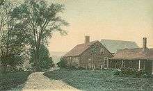
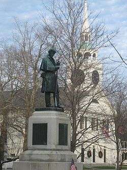 Amherst Town Common in 2006 | ||
| ||
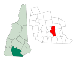 Location in Hillsborough County, New Hampshire | ||
| Coordinates: 42°51′41″N 71°37′31″W / 42.86139°N 71.62528°WCoordinates: 42°51′41″N 71°37′31″W / 42.86139°N 71.62528°W | ||
| Country | United States | |
| State | New Hampshire | |
| County | Hillsborough | |
| Incorporated | 1760 | |
| Government | ||
| • Board of Selectmen |
Dwight Brew, Chair Peter Lyon Reed Panasiti John D'Angelo Tom Grella | |
| • Town Administrator | James M. O'Mara, Jr. | |
| Area | ||
| • Total | 34.7 sq mi (89.9 km2) | |
| • Land | 34.2 sq mi (88.5 km2) | |
| • Water | 0.6 sq mi (1.5 km2) 1.51% | |
| Elevation | 259 ft (79 m) | |
| Population (2010) | ||
| • Total | 11,201 | |
| • Density | 328/sq mi (126.5/km2) | |
| Time zone | UTC−5 (Eastern) | |
| • Summer (DST) | UTC−4 (Eastern) | |
| ZIP code | 03031 | |
| Area code | 603 | |
| FIPS code | 33-01300 | |
| GNIS feature ID | 0873531 | |
| Website |
www | |
Amherst is a town in Hillsborough County, New Hampshire, United States. The population was 11,201 at the 2010 census.[1] Amherst is home to Ponemah Bog Wildlife Sanctuary, Hodgman State Forest, the Joe English Reservation and Baboosic Lake.
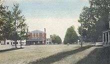
The town center village, where 613 people resided at the 2010 census,[2] is defined as the Amherst census-designated place. The village is also listed on the National Register of Historic Places as Amherst Village Historic District.
History
Like many New England towns, Amherst was the result of a land grant given to soldiers – in this case, to soldiers in 1728 who had participated in King Philip's War. Settled about 1733, it was first called "Narragansett Number 3", and then later "Souhegan Number 3". In 1741, settlers formed the Congregational church and hired the first minister. Chartered on 18 January 1760[3] by Colonial Governor Benning Wentworth, the town was named for General Lord Amherst,[4] who commanded British forces in North America during the French and Indian War. Lord Jeffrey Amherst is also infamous for initiating the practice of giving smallpox blankets to Native Americans in a genocidal effort "to Extirpate this Execrable Race" (as quoted from his letter to Colonel Henry Bouquet on July 16, 1763).
In 1770, Amherst became the county seat of Hillsborough County, due largely to its location on the county's major east-west road. It continued to prosper through the Revolutionary War and afterwards. In 1790, the southwestern section broke off and became the town of Milford, and in 1803, the northwest section departed to become Mont Vernon. The development of water-powered mills allowed Milford to grow at Amherst's expense, and the county seat was moved to Milford in 1866.
The town population remained relatively stagnant until after World War II, when Amherst and many surrounding towns saw an influx of newcomers as they became part of the greater Boston region.
Franklin Pierce, who later become the 14th President of United States of America, studied under Judge Edmund Parker in Amherst. He wed Jane Means Appleton, the daughter of a former president of Bowdoin College, in a house on the town green.
The Nashua and Wilton Railroad passed through Amherst.[4]
Geography
According to the United States Census Bureau, the town has a total area of 34.7 square miles (89.9 km2), of which 34.2 square miles (88.5 km2) is land and 0.54 square miles (1.4 km2) is water, comprising 1.51% of the town.[5] Located on the Souhegan River, Amherst is drained by Beaver, Bloody, and Joe English brooks. Amherst's highest point is on Chestnut Hill at the town's northern border, where the elevation reaches 865 feet (264 m) above sea level. Amherst lies fully within the Merrimack River watershed.[6]
Amherst is bordered by Mont Vernon and New Boston to the northwest, Bedford to the northeast, Merrimack to the east, Hollis to the south, and Milford to the southwest.
Demographics
| Historical population | |||
|---|---|---|---|
| Census | Pop. | %± | |
| 1790 | 2,369 | — | |
| 1800 | 1,470 | −37.9% | |
| 1810 | 1,554 | 5.7% | |
| 1820 | 1,622 | 4.4% | |
| 1830 | 1,657 | 2.2% | |
| 1840 | 1,565 | −5.6% | |
| 1850 | 1,613 | 3.1% | |
| 1860 | 1,598 | −0.9% | |
| 1870 | 1,353 | −15.3% | |
| 1880 | 1,225 | −9.5% | |
| 1890 | 1,053 | −14.0% | |
| 1900 | 1,231 | 16.9% | |
| 1910 | 1,060 | −13.9% | |
| 1920 | 868 | −18.1% | |
| 1930 | 1,115 | 28.5% | |
| 1940 | 1,174 | 5.3% | |
| 1950 | 1,461 | 24.4% | |
| 1960 | 2,051 | 40.4% | |
| 1970 | 4,605 | 124.5% | |
| 1980 | 8,243 | 79.0% | |
| 1990 | 9,068 | 10.0% | |
| 2000 | 10,769 | 18.8% | |
| 2010 | 11,201 | 4.0% | |
| Est. 2015 | 11,261 | [7] | 0.5% |
| U.S. Decennial Census[8] | |||
As of the census of 2010, there were 11,201 people, 4,063 households, and 3,322 families residing in the town. The population density was 327.5 people per square mile (126.5/km²). There were 4,280 housing units at an average density of 125.1 per square mile (48.4/km²). The racial makeup of the town was 95.8% White, 0.5% African American, 0.1% Native American, 1.7% Asian, 0.04% Pacific Islander, 0.4% some other race, and 1.5% from two or more races. Hispanic or Latino of any race were 1.9% of the population.[9]
There were 4,063 households, out of which 37.7% had children under the age of 18 living with them, 72.2% were headed by married couples living together, 6.7% had a female householder with no husband present, and 18.2% were non-families. 14.5% of all households were made up of individuals, and 6.0% were someone living alone who was 65 years of age or older. The average household size was 2.76, and the average family size was 3.06.[9]
In the town, the age distribution of the population was 26.0% under the age of 18, 5.6% from 18 to 24, 19.4% from 25 to 44, 36.5% from 45 to 64, and 12.5% who were 65 years of age or older. The median age was 44.4 years. For every 100 females, there were 97.0 males. For every 100 females age 18 and over, there were 96.5 males.[5]
For the period 2011-2015, the estimated median annual income for a household in the town was $121,349, and the median income for a family was $130,278. Male full-time workers had a median income of $102,869, versus $51,473 for females. The per capita income for the town was $49,190. About 1.8% of families and 2.9% of the population were below the poverty line, including 3.4% of those under age 18 and 2.6% of those age 65 or over.[10]
Public education
Amherst is home to Clark and Wilkins elementary schools, Amherst Middle School and Souhegan High School. The elementary schools handle children from Amherst only. Seventh and eighth graders from neighboring Mont Vernon attend the middle school on a tuition basis, while Amherst and Mont Vernon jointly own Souhegan High School, which serves both towns.[11]
Notable people
- Charles G. Atherton (1804–1853), U.S. congressman and senator[12]
- Charles Humphrey Atherton (1773–1853), U.S. congressman[13]
- Courtney Banghart (b. 1978), head women's basketball coach at Princeton University. (Souhegan High School, '95)[14]
- John S. Barry (1802–1870), fourth and eighth Governor of Michigan[15]
- Samuel Bell, 14th Governor of New Hampshire[16]
- Moses Billings (1809–1884), portrait artist[17]
- Ainsworth Blunt (1800–1865), missionary to the Cherokee in Georgia
- Hubert Buchanan (b 1941), prisoner of war in Vietnam[18]
- Clifton Clagett (1762–1829), U.S. congressman[19]
- Jonathan Fisk (1778–1832), U.S. congressman from New York[20]
- Horace Greeley (1811–1872), editor, founder of the Liberal Republican Party[21]
- Jon "maddog" Hall (b. 1950), programmer, computer scientist, free software advocate[22]
- Neal Huntington (b. 1969), General Manager of the Pittsburgh Pirates (2007–present)[23]
- Moses Nichols (1740–1790), physician, Revolutionary War era soldier and statesman[24]
- Jane Means (Appleton) Pierce (1806–1863), first lady, wife of Franklin Pierce[25]
- Frank Selee (1859–1909), manager for the Boston Beaneaters and Chicago Orphans, member of Baseball Hall of Fame[26]
Trivia
- The town song of Amherst, Amherst is my Home, was composed by James Durst on a grant from the New Hampshire State Council on the Arts/NEA.[27]
References
- ↑ "Amherst, New Hampshire". American FactFinder – 2010 Demographic Profile. U.S. Census Bureau. Retrieved 2017-01-07.
- ↑ United States Census Bureau, American FactFinder, 2010 Census figures. Retrieved March 23, 2011.
- ↑ Hayward's New England Gazetteer (1839)
- 1 2 Statistics and Gazetteer of New-Hampshire (1875)
- 1 2 "Geographic Identifiers: 2010 Demographic Profile Data (G001): Amherst town, Hillsborough County, New Hampshire". U.S. Census Bureau, American Factfinder. Retrieved February 7, 2017.
- ↑ Foster, Debra H.; Batorfalvy, Tatianna N.; Medalie, Laura (1995). Water Use in New Hampshire: An Activities Guide for Teachers. U.S. Department of the Interior and U.S. Geological Survey.
- ↑ "Annual Estimates of the Resident Population for Incorporated Places: April 1, 2010 to July 1, 2015". Retrieved July 2, 2016.
- ↑ "Census of Population and Housing". Census.gov. Archived from the original on May 12, 2015. Retrieved June 4, 2016.
- 1 2 "Profile of General Population and Housing Characteristics: 2010 Census Summary File 1 (DP-1): Amherst town, Hillsborough County, New Hampshire". U.S. Census Bureau, American Factfinder. Retrieved February 7, 2017.
- ↑ "Selected Economic Characteristics: 2011-2015 American Community Survey 5-Year Estimates (DP03): Amherst town, Hillsborough County, New Hampshire". U.S. Census Bureau, American Factfinder. Retrieved February 7, 2017.
- ↑ "School Administrative Unit 39". Retrieved 2017-02-07.
- ↑ "ATHERTON, Charles Gordon, (1804 - 1853)". Biographical Directory of the United States Congress. Retrieved January 19, 2014.
- ↑ "ATHERTON, Charles Humphrey, (1773–1853)". Biographical Directory of the United States Congress. Retrieved January 19, 2014.
- ↑ "U.S.A. Basketball". May 1, 2017.
- ↑ PORTRAIT AND BIOGRAPHICAL ALBUM OF Barry and Eaton Counties, Mich. 1891. p. 113.
- ↑ "BELL, Samuel, (1770 - 1850)". Biographical Directory of the United States Congress. Retrieved January 14, 2014.
- ↑ "Best Face Forward Portraits from the Society's Collection April through September 2009". The Stamford Historical Society. Retrieved January 19, 2014.
- ↑ "Buchanan, Hubert Elliot". POW Network. Retrieved November 13, 2015.
- ↑ "CLAGETT, Clifton, (1762 - 1829)". Biographical Directory of the United States Congress. Retrieved January 19, 2014.
- ↑ "FISK, Jonathan, (1778 - 1832)". Biographical Directory of the United States Congress. Retrieved January 19, 2014.
- ↑ "Horace Greeley". Encyclopædia Britannica. Retrieved January 19, 2014.
- ↑ Brooks, David (November 25, 2013). "Amherst's Jon 'Maddog' Hall is still leading the Linux legions, from do-it-yourselfers to supercomputers". Nashua Telegraph. Retrieved January 19, 2014.
- ↑ "Major League Overhaul". Amherst College. Retrieved January 19, 2014.
- ↑ "Amherst N.H." Hayward's New England Gazetteer (1839) page 28. Retrieved January 19, 2014.
- ↑ "The President's Wife, Jane Means Appleton Pierce: A Woman of Her Time" (PDF). NH History.org. Archived from the original (PDF) on February 1, 2014. Retrieved January 19, 2014.
- ↑ "Selee, Frank". National Baseball Hal of Fame Museum. Retrieved January 19, 2014.
- ↑
External links
| Wikivoyage has a travel guide for Amherst (New Hampshire). |
| Wikimedia Commons has media related to Amherst, New Hampshire. |
- Hayward’s New England Gazetteer (1839)
- Statistics and Gazetteer of New-Hampshire (1875)
- Town of Amherst official website
- Amherst Historical Society
- Amherst Town Library
- New Hampshire Economic and Labor Market Information Bureau Profile
- Peabody Mill Environmental Center
Places adjacent to Amherst, New Hampshire | |
|---|---|
Municipalities and communities of Hillsborough County, New Hampshire, United States | ||
|---|---|---|
| Cities | 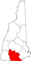 | |
| Towns | ||
| CDPs | ||
| Other villages | ||