Boscawen, New Hampshire
| Boscawen, New Hampshire | |
|---|---|
| Town | |
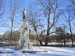 Hannah Duston statue | |
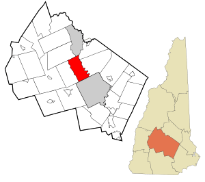 Location in Merrimack County and the state of New Hampshire. | |
| Coordinates: 43°18′54″N 71°37′15″W / 43.31500°N 71.62083°WCoordinates: 43°18′54″N 71°37′15″W / 43.31500°N 71.62083°W | |
| Country | United States |
| State | New Hampshire |
| County | Merrimack |
| Incorporated | 1760 |
| Government | |
| • Board of Selectmen |
Mark E. Varney, Chair Roger W. Sanborn Edward J. Cherian Jr. |
| Area | |
| • Total | 25.4 sq mi (65.8 km2) |
| • Land | 24.7 sq mi (64.1 km2) |
| • Water | 0.7 sq mi (1.8 km2) 2.68% |
| Elevation | 319 ft (97 m) |
| Population (2010) | |
| • Total | 3,965 |
| • Density | 160/sq mi (60/km2) |
| Time zone | UTC-5 (Eastern) |
| • Summer (DST) | UTC-4 (Eastern) |
| ZIP code | 03303 |
| Area code(s) | 603 |
| FIPS code | 33-06260 |
| GNIS feature ID | 0873547 |
| Website | www.townofboscawen.org |
Boscawen is a town in Merrimack County, New Hampshire, United States. The population was 3,965 at the 2010 census.
History
The native Pennacook tribe called the area Contoocook, meaning "place of the river near pines." On June 6, 1733, Governor Jonathan Belcher granted it to John Coffin and 90 others, most from Newbury, Massachusetts. Settled in 1734, it soon had a meetinghouse, sawmill, gristmill and ferry across the Merrimack River. A garrison offered protection, but raiding parties during the French and Indian Wars left some dead or carried into captivity.[1]
On April 22, 1760, Contoocook Plantation was incorporated as a town by Governor Benning Wentworth, who named it for Edward Boscawen, the British admiral who distinguished himself at the 1758 Siege of Louisbourg. With a generally level surface, the town provided good farmland, and became noted for its apple, pear and cherry orchards. Bounded by the Merrimack and Contoocook rivers, it had abundant sources of water power for mills.
Industries soon included a cotton mill, a woolen factory, nine sawmills, a gristmill, a saw manufacturer and machine shop, and a chair and match factory. A mill town village developed at Fisherville (now Penacook), which straddled the river border with Concord.[1] In 1846, the Northern Railroad was built through Boscawen, opening the following winter.[2]
Sometime around 1846, the town's postmaster became one of about a dozen in the country to issue provisional postage stamps before the official issue came out in 1847. The stamps were an adaptation of a postmark, simply reading PAID / 5 / CENTS, typeset in blue on a yellowish paper. These are extremely rare; in 2003, the estimated price at auction was US$225,000.[3]
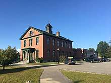
The 1915 Boscawen Public Library was designed by noted Boston architect Guy Lowell.
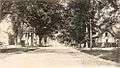 Street view c. 1905
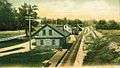 B. & M. Station in 1908
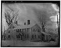 The Penacook House
Geography
According to the United States Census Bureau, the town has a total area of 25.4 square miles (66 km2), of which 24.7 sq mi (64 km2) is land and 0.7 sq mi (1.8 km2) is water, comprising 2.68% of the town. The highest point in Boscawen is an unnamed summit at Raleigh Farm near the town's northern border, where the elevation reaches approximately 930 feet (280 m) above sea level. Boscawen lies fully within the Merrimack River watershed.[4] It is drained by the Merrimack River and Contoocook River.
The town is served by U.S. Route 3 and U.S. Route 4.
Demographics
| Historical population | |||
|---|---|---|---|
| Census | Pop. | %± | |
| 1790 | 1,108 | — | |
| 1800 | 1,414 | 27.6% | |
| 1810 | 1,829 | 29.3% | |
| 1820 | 2,113 | 15.5% | |
| 1830 | 2,093 | −0.9% | |
| 1840 | 1,965 | −6.1% | |
| 1850 | 2,063 | 5.0% | |
| 1860 | 2,274 | 10.2% | |
| 1870 | 1,637 | −28.0% | |
| 1880 | 1,381 | −15.6% | |
| 1890 | 1,487 | 7.7% | |
| 1900 | 1,455 | −2.2% | |
| 1910 | 1,240 | −14.8% | |
| 1920 | 1,260 | 1.6% | |
| 1930 | 1,359 | 7.9% | |
| 1940 | 1,663 | 22.4% | |
| 1950 | 1,857 | 11.7% | |
| 1960 | 2,181 | 17.4% | |
| 1970 | 3,162 | 45.0% | |
| 1980 | 3,435 | 8.6% | |
| 1990 | 3,586 | 4.4% | |
| 2000 | 3,672 | 2.4% | |
| 2010 | 3,965 | 8.0% | |
| Est. 2015 | 3,952 | [5] | −0.3% |
| U.S. Decennial Census[6] | |||
As of the census[7] of 2000, there were 3,672 people, 1,260 households, and 913 families residing in the town. The population density was 148.5 people per square mile (57.3/km²). There were 1,295 housing units at an average density of 52.4 per square mile (20.2/km²). The racial makeup of the town was 97.74% White, 0.57% African American, 0.30% Native American, 0.46% Asian, 0.16% from other races, and 0.76% from two or more races. Hispanic or Latino of any race were 0.82% of the population.
There were 1,260 households out of which 35.1% had children under the age of 18 living with them, 55.0% were married couples living together, 12.7% had a female householder with no husband present, and 27.5% were non-families. 21.3% of all households were made up of individuals and 7.9% had someone living alone who was 65 years of age or older. The average household size was 2.57 and the average family size was 2.97.
In the town, the population was spread out with 22.9% under the age of 18, 7.7% from 18 to 24, 29.2% from 25 to 44, 21.7% from 45 to 64, and 18.5% who were 65 years of age or older. The median age was 39 years. For every 100 females, there were 92.2 males. For every 100 females age 18 and over, there were 89.4 males.
The median income for a household in the town was $42,524, and the median income for a family was $45,850. Males had a median income of $31,350 versus $23,375 for females. The per capita income for the town was $18,732. About 5.4% of families and 7.5% of the population were below the poverty line, including 9.8% of those under age 18 and 10.7% of those age 65 or over.
Elektrisola Incorporated is the largest source of employment for Boscawen-area residents.
Sites of interest
Notable people
- Moody Currier, 40th governor of New Hampshire
- John Adams Dix, New York City Postmaster, 24th governor of New York, Major General in the US Civil War
- Marion Dix Sullivan, songwriter and composer
- Moses G. Farmer, electrical engineer and inventor
- William P. Fessenden, US senator and Secretary of the Treasury
- Charles Gordon Greene, journalist
- Nathaniel Greene, journalist
- Lucia Ames Mead, pacifist, feminist author and educator
- Lyndon A. Smith, politician and Minnesota attorney general
- Bradford N. Stevens, US congressman
- Daniel Webster, US congressman, senator, and Secretary of State; unsuccessful presidential candidate
References
- 1 2 Coolidge, Austin J.; John B. Mansfield (1859). A History and Description of New England. Boston, Massachusetts. pp. 424–426.
- ↑ Charles Carleton Coffin, The History of Boscawen and Webster from 1733 to 1878; Concord, New Hampshire 1878
- ↑ Boscawen provisional postage stamps Archived March 3, 2009, at the Wayback Machine.
- ↑ Foster, Debra H.; Batorfalvy, Tatianna N.; Medalie, Laura (1995). Water Use in New Hampshire: An Activities Guide for Teachers. U.S. Department of the Interior and U.S. Geological Survey.
- ↑ "Annual Estimates of the Resident Population for Incorporated Places: April 1, 2010 to July 1, 2015". Retrieved July 2, 2016.
- ↑ "Census of Population and Housing". Census.gov. Archived from the original on May 12, 2015. Retrieved June 4, 2016.
- ↑ "American FactFinder". United States Census Bureau. Archived from the original on 2013-09-11. Retrieved 2008-01-31.
External links
| Wikimedia Commons has media related to Boscawen, New Hampshire. |
- Town of Boscawen official website
- Boscawen Public Library
- New Hampshire Economic and Labor Market Information Bureau Profile
Places adjacent to Boscawen, New Hampshire | |
|---|---|
Municipalities and communities of Merrimack County, New Hampshire, United States | ||
|---|---|---|
| Cities | 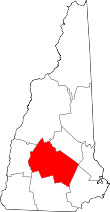 | |
| Towns | ||
| CDPs | ||
| Other unincorporated communities | ||
| Footnotes | ‡This populated place also has portions in an adjacent county or counties | |