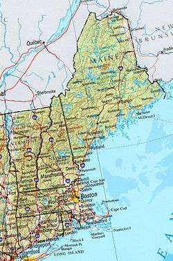
Geology of New England
New England is a region in the North Eastern United States consisting of the states Rhode Island, Connecticut, Massachusetts, New Hampshire, Vermont, and Maine. Most of New England consists geologically of volcanic island arcs that accreted onto the eastern edge of the Laurentian Craton in prehistoric times. Much of the bedrock found in New England is heavily metamorphosed due to the numerous mountain building events that occurred in the region. These events culminated in the formation of Pangaea; the coastline as it exists today was created by rifting during the Jurassic and Cretaceous periods. The most recent rock layers are glacial conglomerates.
Chronology
Overview
The bedrock geology of New England was heavily influenced by various tectonic events that have occurred since the Paleozoic Era including the accretion of land masses that formed various continental terranes to the Mesozoic rifting of the Hartford Basin.
Archean and Proterozoic eons
In the Archean Eon Western Massachusetts and Vermont were the eastern edge of Laurentia (now the Canadian Shield). Laurentia is believed to have originated at the end of the Hadean, making it one of the oldest regions with continental crust, as evidenced by the discovery of Acasta Gneiss in Canada. At the end of the Hadean massive eruptions of felsic lava became cool enough to form permanent crust. The felsic nature of Laurentia allowed it to float over the denser ocean basins that surrounded it, so it was not submerged under the then-forming oceans. During the Archean Eon the surface of New England was a coastal desert covered by silica-rich sediments with outcroppings of granite bedrock.
Paleozoic Era
Starting in the Paleozoic Era the supercontinent Pannotia began to break up, forming smaller continents including Laurentia (North America and Greenland), Gondwana, Baltica, and Siberia. At the same time sea levels were rising, which resulted in the flooding of most of the continents with shallow epicontinental seas. This was followed by three periods of extensive orogeny.[1] Much of the geology in New England is based on formation of the Appalachian Mountains through a series of Paleozoic accretion episodes to the terminal collision between Laurentia (proto–North America) and Gondwana (proto–Africa–South America) at ca. 300 Ma.[2]
Ordovician Period
During the Middle Ordovician, during the Taconic orogeny, volcanic island arcs collided with the east coast of North America causing extensive metamorphism, faulting, and uplift, the result of which was the Taconic Mountains on the border of New York and New England.[3] After the Taconic orogeny, the Humber seaway was on its way to closure and Dashwoods microcontinent accreted to Laurentia. This then led to the accretion of oceanic terranes including the Bay of Islands in Newfoundland and Thetford Mines Ophiolites in Quebec. Additionally, the Late-Ordovician-Early Silurian Mélange was present, which consisted of blueschists and deepwater deposits, and indicates that subduction continued during this time.
Silurian Period
Closure of the Tetagouche-Exploits back-arc in the Early Silurian (430 Ma) accreted the bulk of Ganderia to Laurentia. This event is known as the Salinic Orogeny and was responsible for most of the bedrock that is found in New Brunswick, Newfoundland, and Maine.[4] Examples include the Rangeley sequence found in the Presidential Range that consists of Silurian and Devonian Turbidite sequences, Early Silurian Rangeley Formation, the Middle to Late Silurian Perry Mountain, Smalls Falls, and Madrid Formations.
Devonian Period
The Acadian orogeny took place during the middle to late Devonian. Following the subduction of the Iapetus Ocean floor, the microcontinent Avalonia slammed into eastern North America, which caused another period of metamorphism, faulting, and mountain building. Evidence for these events can be found within the Littleton Formation on the summits of the Presidential Range in northern New Hampshire and southern Maine. The Littleton Formation was deposited in the Early Devonian, approximately 409 million years ago with a Gander and/or Avalon Terrane source.[5] The lower part of this formation is found proximal to the Bronson Hill Island Arc and consists of basaltic and rhyolitic volcanic rocks along with low grade metamorphic shale while the upper part of this formation consists of the youngest rocks of the Presidential Range. This area has experienced extensive deformation which is expressed as pre-metamorphic faults, various folds, thrust faults, and doming. Evidence for igneous activity include the early-Devonian (408 Ma) diorites, early to mid-Devonian (390–400 Ma) granites, and the Carboniferous (360–350 Ma) granites.[5]
Carboniferous and Permian periods
The Alleghenian Orogeny occurred during the late Paleozoic and was the result of the collision of Africa with North America during the formation of Pangea. The collision events produced tremendous occurrences of thrust faults, folding, and metamorphism. As a result of this collision event a huge mountain belt formed that ran up the east coast of North America into Canada and Baltica, which had collided with Greenland and northern North America.[1] Rocks were newly deformed and folded from the coast to as far as the Allegheny Plateau and the Adirondack Mountains of New York.[6] Although the modern-day Appalachian Mountains have been heavily weathered over time, they were thought to once rival the Himalayas in size.[7]
Mesozoic Era
Jurassic Period
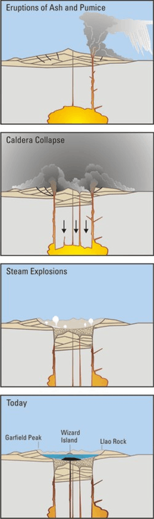
New England, like the rest of the eastern United States, does not contain any active volcanoes in the present era. However, the White Mountains region of New Hampshire contains strong evidence of volcanic activity approximately 145 million years ago.[8] Volcanic formation in the White Mountains has been estimated to have occurred between the late Jurassic and early Cretaceous periods, and would have coincided with the separation of Pangaea.[8] As Pangaea broke apart and land masses were shifting, large features like the White Mountains were formed; at the same time, as this multitude of cracks was occurring, magma rose up and filled many of these voids.[8] In this manner calderas were formed throughout the White Mountains as magma receded; these calderas then subsequently erupted on a scale dwarfing the 1980 eruption of Mount St. Helens.[8] The results of these massive eruptions can be found in such places as the Ossipee Mountains, which are located proximal to the White Mountains. The Ossipee Mountains contain substantial amounts of volcanic rock, and the many ring dikes across the region indicate that there was once an active volcano on the site.[9][10] Volcanic rocks can also be found throughout the White Mountains beyond the Ossipee region, further confirming that eruptions occurred across the area millions of years ago.
Cenozoic Era
Quaternary Period
Much of the geomorphology and surficial deposits of New England are a result of glaciation in the Quaternary period. The scoured New England landscape reveals evidence of the Wisconsin Glacial Period.
Surficial deposits
The continental ice sheet over New England was more than a mile thick in some places.[11] Grinding and plucking over the landscape created wore down topography and created poorly sorted to well sorted surficial deposits. Large terminal moraines composed of poorly sorted till are present along coasts and can be identified by their thin, patchy, and stony texture.[11] Maine is bordered by moraines that identify the terminus margins of the past ice bodies. The Waldoboro terminal moraine sits on the southeastern coast, while the Highland front moraine parallels the northwestern border. Large continental ice sheets (see Laurentide Ice Sheet) most likely created the large moraines, as it takes time for the long, lumpy ridges to form at a massive scale.[12]
New England is best known for its high density of erratics, which are displaced rocks that differ from the immediate bedrock composition of the region and range from the size of pebbles to boulders. Their surfaces are generally rounded and polished due to rasping.[13] While the bedrock of the area is largely igneous granite, the erratics are sandstone and slate blocks.[12] Sedimentary erratics are visible across the highest peak in Maine, Mount Katahdin.
Glacial outwash that is well sorted and stratified due to the systematic nature of Stoke’s Law is visible in gravel pits in Maine's Grafton Notch State Park Outwash plains are composed of alternating layers of sand and gravel that have been deposited in deltas of glacial lakes and alluvial fans.
Erosional processes
The slow and grinding movement of continental ice sheets and alpine glaciers across the landscape creates erosional landforms. Abrasion, plucking, and freeze-thaw action creates the U-shaped valley unique to glacial erosion.
The intense pressure from the ice causes abrasion. This process carves striations, or grooves, into the bedrock as the glacier moves down a slope. Glacial striations help determine the direction of a glacier; visible outcrops in the White Mountains, for instance, indicate ice flow toward the south-southeast.[14] Abrasion also produces rock flour which is visible in glacial outwash plains across New England.
Maine has some of the longest eskers in the world.[12] As the climate began to warm, the glaciers began to melt and drainage from meltwater under the glacier formed huge torrents of sediment that, when compacted, left a long and sinuous ridge or kame. Moose Cave in Grafton Notch is speculated to have been formed in part by a subglacial river.[15] Abol esker in Baxter State Park is a notable serpentine kame.
Kame and kettle topography is commonplace across Maine. Hummocky morphology includes kettle ponds and kettle lakes that are “steep-sided, bowl-shaped depressions in glacial drift deposits” [12] where large blocks of ice melted as the glacier recessed.
Other notable glacial features include Cirques. Mt. Katahdin and the Bigelow Range have circular divets indicative of glacial erosion.
Holocene Epoch
Following the glacial melting of the Laurentide Ice Sheet, new vegetation and warmer climate caused new New England to become inhabitable by early human settlers. This new climate, combined with an ample supply of hard volcanic rock and other natural features, created an ideal area for human settlement. These settlers fashioned tools, such as arrowheads, from surficial rhyolite deposits they found near what could have been their river valley settlements.

The melting of the Laurentide Ice Sheet (beginning by 18,000 cal yr BP), which covered what is currently the New England landscape up until the late Pleistocene era, caused significant ecological and climatic change in the region.[16] Except for a number of abrupt climate reversals, the most extreme being the cold reversal of the Younger Dryas, the climate of the region generally experienced a rise in temperature (of up to 2˚ Celsius) during the early Holocene.[17] Fossil pollen findings indicate that the increased temperature in the region paralleled new vegetation patterns, such as the rise of hemlock and white pine in New Hampshire and the White Mountains.[17] These vegetation shifts created ecological environments in the region where habitation by migratory caribou, which were hunted by early human settlers, was possible.[18] These settlers could have moved to recently formed dune fields, which were produced by wind erosion of glacial outwash deposits, such as those found in the Ohio Valley, in the Hudson and Connecticut River valleys, and in the Israel River valley.[18] Early human settlers could have populated these river valleys in order to observe the caribou migrating northeast along the newly formed rivers.[19]
References
- 1 2 Marshank, Stephen, 2009, Essentials of Geology, Third Edition, Norton, p. 306-308.
- ↑ Hatcher, R. D., 2010, The Appalachian orogen: A brief summary: Geological Society of America Memoirs, v. 206, p. 1-19.
- ↑ Raymo, Chet and Raymo, Maureen E. (1989). Written in Stone: A Geologic History of the Northeastern United States. Chester, Connecticut: Globe Pequot.
- ↑ Van Staal, C., 2005, The Northern Appalachians: Encyclopedia of geology, v. 4, p. 81-91.
- 1 2 Eusden J. D. Jr., Guzofski, C. A., Robinson, A. C., and Tucker, R. D., 2000, Timing of the Acadian Orogeny in Northern New Hampshire, Journal of Geology, v. 108. p. 219-232.
- ↑ Van Diver, Bradford (1987). Roadside Geology of Vermont and New Hampshire. Montana: Mountain Press Publishing Company. pp. 29–31. ISBN 978-0878422036.
- ↑ http://www.priweb.org/ed/TFGuide/SE/se_geohist/se_geohist_pdfs/appalachians.pdf
- 1 2 3 4 "Geology of the White Mountains Part 2: The Mountain Building Events - AMC Outdoors". AMC Outdoors. 2009-02-03. Retrieved 2017-10-20.
- ↑ News, A. B. C. (2006-01-07). "Tourists Venture Inside a Volcano in New Hampshire". ABC News. Retrieved 2017-10-20.
- ↑ "Ossipee Mountains in Volcanoes in New Hampshire - Plymouth Portfolio". www.plymouth.edu. Retrieved 2017-10-20.
- 1 2 B., VanDiver, Bradford (1987). Roadside geology of Vermont and New Hampshire. Missoula: Mountain Press Pub. Co. ISBN 9780878422036. OCLC 15315645.
- 1 2 3 4 Caldwell, Dabney (1998). Caldwell, D.W., 1998, “Roadside Geology of Maine,” Mountain Press Publishing Company, Missoula MT. Mountain Press Publishing Company.
- ↑ Marshak, Stephen (2015-07-21). Earth: Portrait of a Planet (5 ed.). W. W. Norton & Company. ISBN 9780393281491.
- ↑ Department of Agriculture, Conservation & Forestry, 2002, Glacial and Postglacial Geology Highlights in the White Mountain National Forest, Western Maine: http://digitalmaine.com/cgi/viewcontent.cgi?article=1359&context=mgs_publications
- ↑ Doughty, A.M., Thompson, W.B., Grafton Notch State Park: Glacial Gorges and Streams under Pressure in the Mahoosic Range, Maine.
- ↑ Dyke, Arthur S.; Prest, Victor K. (1987). "Late Wisconsinan and Holocene History of the Laurentide Ice Sheet". Géographie physique et Quaternaire. 41 (2): 237. doi:10.7202/032681ar. ISSN 0705-7199.
- 1 2 Davis, Margaret B.; Spear, Ray W.; Shane, Linda C. K. (1980). "Holocene Climate of New England". Quaternary Research. 14 (2): 240–250. Bibcode:1980QuRes..14..240D. doi:10.1016/0033-5894(80)90051-4. ISSN 0033-5894.
- 1 2 Lothrop, Jonathan C.; Lowery, Darrin L.; Spiess, Arthur E.; Ellis, Christopher J. (2016-07-02). "Early Human Settlement of Northeastern North America". PaleoAmerica. 2 (3): 192–251. doi:10.1080/20555563.2016.1212178. ISSN 2055-5563.
- ↑ Baker, Sarah; Survey, New Hampshire Geological; Richard, Boisvert; Eusden, J. Dykstra; Hamilton, Nathan; Pollock, Stephen; Resources, New Hampshire Division of Historical; College, Bates; Maine, University of Southern (2017). "The New Hampshire Spherulitic Rhyolites: Rocks of Importance to Prehistoric Native Americans". New England Intercollegiate Geological Conference 2017. Bates College: 305. doi:10.26780/2017.001.0017.