Tuftonboro, New Hampshire
| Tuftonboro, New Hampshire | |
|---|---|
| Town | |
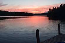
 Melvin Village from Lake Winnipesaukee c. 1906 | |
| Motto(s): "The Diamond in the Heart of New Hampshire" | |
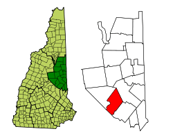 Location in Carroll County, New Hampshire | |
| Coordinates: 43°41′46″N 71°13′21″W / 43.69611°N 71.22250°WCoordinates: 43°41′46″N 71°13′21″W / 43.69611°N 71.22250°W | |
| Country | United States |
| State | New Hampshire |
| County | Carroll |
| Incorporated | 1795 |
| Villages |
Center Tuftonboro Melvin Village Mirror Lake Tuftonboro Corner Union Wharf |
| Government | |
| • Board of Selectmen |
Lloyd Wood, Chair William J. Marcussen William "Chip" Albee |
| Area | |
| • Total | 50.0 sq mi (129.5 km2) |
| • Land | 41.0 sq mi (106.1 km2) |
| • Water | 9.0 sq mi (23.4 km2) 18.07% |
| Elevation | 988 ft (301 m) |
| Population (2010) | |
| • Total | 2,387 |
| • Density | 48/sq mi (18/km2) |
| Time zone | UTC-5 (Eastern) |
| • Summer (DST) | UTC-4 (Eastern) |
| ZIP codes | 03816, 03850, 03853, 03894 |
| Area code(s) | 603 |
| FIPS code | 33-77620 |
| GNIS feature ID | 0873741 |
| Website |
www |
Tuftonboro is a town in Carroll County, New Hampshire, United States. The population was 2,387 at the 2010 census.[1] Bounded on the southwest by Lake Winnipesaukee, Tuftonboro includes the villages of Tuftonboro Corner, Center Tuftonboro, Melvin Village and Mirror Lake.
History

Tuftonboro was the only incorporated place in New Hampshire owned by just one man, John Tufton Mason, for whom the town was named. Following the 1741 separation of New Hampshire from Massachusetts, Mason was heir to the Masonian Claim, the undivided lands of northern New Hampshire. He sold them in 1746 to a group of Portsmouth merchants, thereafter known as the Masonian Proprietors. They disposed of the land via grants to prospective settlers prior to the Revolution.
The town was granted as Tuftonborough in 1750 by Colonial Governor Benning Wentworth, and first settled about 1780. It was incorporated by the legislature on December 17, 1795. By 1859, when the population was 1,305, the principal occupation was raising cattle and sheep across the hilly terrain. Other industries included 2 sawmills, one sash, blind and door factory, one carriage factory, and 2 gristmills.[2]
Geography
According to the United States Census Bureau, the town has a total area of 50.0 square miles (129 km2), of which 41.0 square miles (106 km2) is land and 9.0 square miles (23 km2) is water, comprising 18.07% of the town.[1] Tuftonboro is drained by the Melvin River and Beech River. Mirror Lake is in the south, and Dan Hole Pond is in the north. The highest point in Tuftonboro is the south peak of Mount Shaw, elevation 2,930 feet (890 m) above sea level, on the town's northwest boundary.
The northern portion of Tuftonboro is occupied by the Ossipee Mountains. New Hampshire routes 171, 109, and 109A cross the town, all generally in a northwest to southeast direction.
Melvin Village, a village of Tuftonboro, is a summer vacation spot on Melvin Bay of Lake Winnipesaukee. It has a marina and many lakeside homes and cottages that are for rent. It is also a popular spot for antique shopping. Melvin Village is in the western part of Tuftonboro, near the town of Moultonborough.
Also part of Tuftonboro are several islands in Lake Winnipesaukee, including Little Bear Island and Cow Island among others.
Demographics
| Historical population | |||
|---|---|---|---|
| Census | Pop. | %± | |
| 1790 | 109 | — | |
| 1800 | 357 | 227.5% | |
| 1810 | 709 | 98.6% | |
| 1820 | 1,232 | 73.8% | |
| 1830 | 1,375 | 11.6% | |
| 1840 | 1,281 | −6.8% | |
| 1850 | 1,305 | 1.9% | |
| 1860 | 1,186 | −9.1% | |
| 1870 | 949 | −20.0% | |
| 1880 | 923 | −2.7% | |
| 1890 | 767 | −16.9% | |
| 1900 | 663 | −13.6% | |
| 1910 | 612 | −7.7% | |
| 1920 | 311 | −49.2% | |
| 1930 | 505 | 62.4% | |
| 1940 | 586 | 16.0% | |
| 1950 | 697 | 18.9% | |
| 1960 | 678 | −2.7% | |
| 1970 | 910 | 34.2% | |
| 1980 | 1,500 | 64.8% | |
| 1990 | 1,842 | 22.8% | |
| 2000 | 2,148 | 16.6% | |
| 2010 | 2,387 | 11.1% | |
| Est. 2016 | 2,098 | [3] | −12.1% |
| U.S. Decennial Census[4] | |||
2010 census
As of the census of 2010,[5] there were 2,387 people and 736 families in the town. The population density was 58.2 people per square mile (22.4/km²). There were 2,435 housing units at an average density of 49.1 per square mile (22.9/km²). The racial makeup of the town was 98.1% White, 0.2% African American, 0.1% Native American, 0.3% Asian, 0.1% some other race, and 1.3% from two or more races. Hispanic or Latino of any race were 0.5% of the population.
There were 1,029 households out of which 26.0% had children under the age of 18 living with them, 61.0% were married couples living together, 6.8% had a female householder with no husband present, 3.7% had a male householder with no wife present, and 28.5% were non-families. 22.8% of all households were made up of individuals, and 11.1% were someone living alone who was 65 years of age or older. The average household size was 2.32, and the average family size was 2.68.[5]

In the town, the population was spread out with 18.9% under the age of 18, 4.3% from 18 to 24, 18.1% from 25 to 44, 35.0% from 45 to 64, and 23.7% who were 65 years of age or older. The median age was 50.8 years. For every 100 females, there were 101.09 males. For every 100 females age 18 and over, there were 99.17 males in the same age group.[5]
For the period 2012-16, the estimated median annual income for a household in the town was $54,770, and the median income for a family was $64,479. Male full-time workers had a median income of $46,346 versus $39,219 for females. The per capita income for the town was $29,554. About 5.0% of families and 6.8% of the population were below the poverty line, including 2.5% of those under age 18 and 6.5% of those age 65 or over.[6]
2000 census
As of the census of 2000, there were 2,148 people, 926 households, and 665 families residing in the town. The population density was 52.2 people per square mile (20.2/km²). There were 2,019 housing units at an average density of 49.1 per square mile (19.0/km²). The racial makeup of the town was 98.32% White, 0.23% Native American, 0.23% Asian, 0.05% from other races, and 1.16% from two or more races. Hispanic or Latinoof any race were 0.42% of the population.
There were 926 households out of which 23.9% had children under the age of 18 living with them, 62.9% were married couples living together, 5.3% had a female householder with no husband present, and 28.1% were non-families. 22.9% of all households were made up of individuals and 9.6% had someone living alone who was 65 years of age or older. The average household size was 2.32 and the average family size was 2.68.
In the town, the population was spread out with 19.8% under the age of 18, 3.8% from 18 to 24, 22.5% from 25 to 44, 31.8% from 45 to 64, and 22.1% who were 65 years of age or older. The median age was 48 years. For every 100 females, there were 97.2 males. For every 100 females age 18 and over, there were 97.4 males.
The median income for a household in the town was $45,729, and the median income for a family was $51,875. Males had a median income of $36,181 versus $27,109 for females. The per capita income for the town was $25,070. About 4.4% of families and 6.4% of the population were below the poverty line, including 7.1% of those under age 18 and 6.1% of those age 65 or over.
Site of interest
Notable people
- Edward H. Brooks, US Army lieutenant general
- Charles D. Griffin, US Navy admiral
- Thomas Dreier, resident, an American editor, writer, and publisher who in the early twentieth century was the first editor of New Hampshire Troubadour,[7] who wrote the 1933 book Sunny Meadows about his family's life in Melvin Village,[8] and who had a column in the Nashua Telegraph[9]
References
- 1 2 "Geographic Identifiers: 2010 Demographic Profile Data (G001): Tuftonboro town, Carroll County, New Hampshire". U.S. Census Bureau, American Factfinder. Retrieved March 12, 2018.
- ↑ A. J. Coolidge & J. B. Mansfield, A History and Description of New England; Boston, Massachusetts 1859
- ↑ "A 2012-2016 American Community Survey 5-Year Estimates". Retrieved March 11, 2018.
- ↑ "Census of Population and Housing". Census.gov. Retrieved June 4, 2016.
- 1 2 3 "Profile of General Population and Housing Characteristics: 2010 Census Summary File 1 (DP-1): Tuftonboro town, Carroll County, New Hampshire". U.S. Census Bureau, American Factfinder. Retrieved March 12, 2018.
- ↑ "Selected Economic Characteristics: 2012-2016 American Community Survey 5-Year Estimates (DP03): Tuftonboro town, Carroll County, New Hampshire". U.S. Census Bureau, American Factfinder. Retrieved March 12, 2018.
- ↑ "Carlson Shows Oils, Water Colors; Whitman Pencil Paintings Also at Public Library Now". Nashua Telegraph. 64 (235). Nashua, New Hampshire. 1932-12-07. p. 5. OCLC 22532489.
- ↑ Murdock, Kenneth B. (1934). "Sunny Meadows by Thomas Dreier; The White Hills: Mountain New Hampshire, Winnepesaukee to Washington by Cornelius Weygandt". The New England Quarterly. MIT Press. 7 (3): 583–585. ISSN 0028-4866. JSTOR 359679.
- ↑ "Sunny Meadows Farm Philosophy". Nashua Telegraph. 63 (256). Nashua, New Hampshire. 1932-01-04. p. 4. OCLC 22532489.
External links
- Town of Tuftonboro official website
- Tuftonboro Free Library
- New Hampshire Economic and Labor Market Information Bureau Profile
Places adjacent to Tuftonboro, New Hampshire | ||||||||||
|---|---|---|---|---|---|---|---|---|---|---|
| ||||||||||
Municipalities and communities of Carroll County, New Hampshire, United States | ||
|---|---|---|
| Towns | 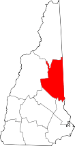 | |
| Township | ||
| CDPs | ||
| Other villages | ||