Plymouth County, Massachusetts
| Plymouth County, Massachusetts | ||
|---|---|---|
| County of Massachusetts | ||
| County of Plymouth | ||
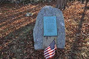 First Church Site marker, Men of Kent Cemetery, Meetinghouse Lane, Scituate, Massachusetts | ||
| ||
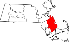 Location in the U.S. state of Massachusetts | ||
 Massachusetts's location in the U.S. | ||
| Founded | 1685 | |
| Seat | Plymouth and Brockton | |
| Largest city | Brockton | |
| Area | ||
| • Total | 1,093 sq mi (2,831 km2) | |
| • Land | 659 sq mi (1,707 km2) | |
| • Water | 434 sq mi (1,124 km2), 40% | |
| Population | ||
| • (2010) | 494,919 | |
| • Density | 751/sq mi (290/km2) | |
| Congressional districts | 4th, 8th, 9th | |
| Time zone | Eastern: UTC−5/−4 | |
| Website |
www | |

Plymouth County is a county in the U.S. state of Massachusetts. As of the 2010 census, the population was 494,919.[1] Its county seats[2] are Plymouth and Brockton.[3] In 1685 the County was created by the Plymouth General Court, the legislature of Plymouth Colony, predating its annexation by the Massachusetts Bay Colony.
Plymouth County is part of the Boston-Cambridge-Newton, MA-NH Metropolitan Statistical Area.
Geography
According to the U.S. Census Bureau, the county has a total area of 1,093 square miles (2,830 km2), of which 659 square miles (1,710 km2) is land and 434 square miles (1,120 km2) (40%) is water.[4] It is the third-largest county in Massachusetts by total area.
Adjacent counties
The towns of Hingham and Hull in Plymouth County extend north of Norfolk County and face onto Massachusetts Bay, sharing a northern water boundary with Suffolk County.
- Norfolk County (north)
- Barnstable County (southeast)
- Bristol County (west)
National protected area
Demographics
| Historical population | |||
|---|---|---|---|
| Census | Pop. | %± | |
| 1790 | 29,512 | — | |
| 1800 | 30,073 | 1.9% | |
| 1810 | 35,169 | 16.9% | |
| 1820 | 38,136 | 8.4% | |
| 1830 | 43,044 | 12.9% | |
| 1840 | 47,373 | 10.1% | |
| 1850 | 55,697 | 17.6% | |
| 1860 | 64,768 | 16.3% | |
| 1870 | 65,365 | 0.9% | |
| 1880 | 74,018 | 13.2% | |
| 1890 | 92,700 | 25.2% | |
| 1900 | 113,985 | 23.0% | |
| 1910 | 144,337 | 26.6% | |
| 1920 | 156,968 | 8.8% | |
| 1930 | 162,311 | 3.4% | |
| 1940 | 168,824 | 4.0% | |
| 1950 | 189,468 | 12.2% | |
| 1960 | 248,449 | 31.1% | |
| 1970 | 333,314 | 34.2% | |
| 1980 | 405,437 | 21.6% | |
| 1990 | 435,276 | 7.4% | |
| 2000 | 472,822 | 8.6% | |
| 2010 | 494,919 | 4.7% | |
| Est. 2016 | 513,565 | [5] | 3.8% |
| U.S. Decennial Census[6] 1790–1960[7] 1900–1990[8] 1990–2000[9] 2010–2013[1] | |||
2000 census
As of the census[10] of 2000, there were 472,822 people, 168,361 households, and 122,398 families residing in the county. The population density was 716 people per square mile (276/km²). There were 181,524 housing units at an average density of 275 per square mile (106/km²). The racial makeup of the county was 88.70% White, 4.56% Black or African American, 0.21% Native American, 0.92% Asian, 0.02% Pacific Islander, 3.06% from other races, and 2.52% from two or more races. 2.44% of the population were Hispanic or Latino of any race. 28.0% were of Irish, 12.8% Italian, 10.6% English and 5.1% American ancestry according to Census 2000. 90.1% spoke English, 2.5% Spanish, 2.3% Portuguese, 1.5% French Creole and 1.0% French as their first language.
There were 168,361 households out of which 36.30% had children under the age of 18 living with them, 57.00% were married couples living together, 11.90% had a female householder with no husband present, and 27.30% were non-families. 22.20% of all households were made up of individuals and 9.00% had someone living alone who was 65 years of age or older. The average household size was 2.74 and the average family size was 3.23.
In the county, the population was spread out with 26.80% under the age of 18, 7.20% from 18 to 24, 30.40% from 25 to 44, 23.90% from 45 to 64, and 11.80% who were 65 years of age or older. The median age was 37 years. For every 100 females, there were 95.00 males. For every 100 females age 18 and over, there were 91.30 males.
The median income for a household in the county was $55,615, and the median income for a family was $65,554 (these figures had risen to $70,335 and $82,560 respectively as of a 2007 estimate[11]). Males had a median income of $45,535 versus $31,389 for females. The per capita income for the county was $24,789. About 4.90% of families and 6.60% of the population were below the poverty line, including 8.30% of those under age 18 and 7.90% of those age 65 or over.
The leading ancestry group in Plymouth County is Irish, with 31%. Plymouth County, along with Norfolk County, Massachusetts, claims the highest percentage of people with Irish ancestry in the United States.[12]
2010 census
As of the 2010 United States Census, there were 494,919 people, 181,126 households, and 127,925 families residing in the county.[13] The population density was 750.9 inhabitants per square mile (289.9/km2). There were 200,161 housing units at an average density of 303.7 per square mile (117.3/km2).[14] The racial makeup of the county was 85.5% white, 7.2% black or African American, 1.2% Asian, 0.2% American Indian, 3.2% from other races, and 2.6% from two or more races. Those of Hispanic or Latino origin made up 3.2% of the population.[13] In terms of ancestry, 33.7% were Irish, 15.8% were Italian, 15.3% were English, 7.3% were German, and 3.7% were American.[15]
Of the 181,126 households, 35.1% had children under the age of 18 living with them, 53.6% were married couples living together, 12.6% had a female householder with no husband present, 29.4% were non-families, and 23.8% of all households were made up of individuals. The average household size was 2.67 and the average family size was 3.18. The median age was 41.1 years.[13]
The median income for a household in the county was $73,131 and the median income for a family was $86,251. Males had a median income of $60,303 versus $43,837 for females. The per capita income for the county was $33,333. About 5.0% of families and 7.0% of the population were below the poverty line, including 8.3% of those under age 18 and 7.0% of those age 65 or over.[16]
Demographic breakdown by town
Income
The ranking of unincorporated communities that are included on the list are reflective if the census designated locations and villages were included as cities or towns. Data is from the 2007–2011 American Community Survey 5-Year Estimates.[17][18][19]
| Rank | Town | Per capita income |
Median household income |
Median family income |
Population | Number of households | |
|---|---|---|---|---|---|---|---|
| Duxbury | CDP | $80,077 | $113,672 | $218,542 | 1,459 | 555 | |
| South Duxbury | CDP | $68,911 | $139,712 | $169,671 | 3,435 | 1,260 | |
| Hingham | CDP | $61,486 | $104,926 | $134,637 | 5,856 | 2,117 | |
| The Pinehills | CDP | $58,507 | $91,875 | $115,819 | 922 | 488 | |
| 1 | Hingham | Town | $56,671 | $99,318 | $132,744 | 21,916 | 8,046 |
| 2 | Duxbury | Town | $55,510 | $122,396 | $139,873 | 14,978 | 5,256 |
| 3 | Norwell | Town | $48,440 | $109,167 | $118,679 | 10,430 | 3,468 |
| Green Harbor | CDP | $47,993 | $128,828 | $134,157 | 2,245 | 876 | |
| Marshfield Hills | CDP | $47,593 | $102,344 | $135,396 | 2,485 | 916 | |
| 4 | Scituate | Town | $47,122 | $89,485 | $111,893 | 18,115 | 6,957 |
| Marion Center | CDP | $45,404 | $83,413 | $97,102 | 1,081 | 435 | |
| 5 | Marion | Town | $43,383 | $87,793 | $90,536 | 4,926 | 1,873 |
| 6 | Hull | Town | $43,290 | $72,036 | $95,964 | 10,391 | 4,672 |
| North Scituate | CDP | $43,214 | $84,712 | $107,606 | 5,394 | 1,955 | |
| Ocean Bluff-Brant Rock | CDP | $42,296 | $77,245 | $89,940 | 4,705 | 1,920 | |
| 7 | Marshfield | Town | $42,269 | $93,743 | $110,756 | 25,059 | 9,322 |
| Scituate | CDP | $40,337 | $69,388 | $107,647 | 5,201 | 2,169 | |
| 8 | Hanover | Town | $39,631 | $100,982 | $114,484 | 13,813 | 4,729 |
| North Lakeville | CDP | $39,363 | $67,361 | $103,456 | 2,174 | 840 | |
| 9 | Mattapoisett | Town | $39,312 | $82,065 | $95,568 | 6,073 | 2,436 |
| 10 | Kingston | Town | $37,783 | $77,288 | $86,489 | 12,556 | 4,624 |
| 11 | Plympton | Town | $37,755 | $93,882 | $102,773 | 2,799 | 991 |
| Kingston | CDP | $36,335 | $67,292 | $75,671 | 5,695 | 2,250 | |
| Marshfield | CDP | $36,112 | $71,938 | $100,855 | 4,501 | 1,838 | |
| 12 | Pembroke | Town | $35,228 | $82,064 | $98,156 | 17,740 | 6,291 |
| Massachusetts | State | $35,051 | $65,981 | $83,371 | 6,512,227 | 2,522,409 | |
| 13 | Lakeville | Town | $35,010 | $93,260 | $104,416 | 10,533 | 3,586 |
| Plymouth Center | CDP | $34,997 | $51,463 | $80,924 | 6,900 | 3,177 | |
| 14 | Rochester | Town | $34,994 | $98,728 | $104,496 | 5,159 | 1,699 |
| 15 | Halifax | Town | $34,880 | $83,522 | $89,456 | 7,516 | 2,798 |
| Mattapoisett Center | CDP | $34,877 | $65,034 | $85,758 | 2,898 | 1,223 | |
| Plymouth County | County | $34,285 | $74,698 | $88,110 | 492,934 | 178,996 | |
| 16 | Plymouth | Town | $33,891 | $76,631 | $90,764 | 56,011 | 20,946 |
| 17 | West Bridgewater | Town | $33,590 | $80,729 | $95,182 | 6,896 | 2,432 |
| 18 | Abington | Town | $33,386 | $81,677 | $92,839 | 15,841 | 5,962 |
| 19 | Hanson | Town | $32,864 | $89,000 | $96,705 | 10,148 | 3,436 |
| North Pembroke | CDP | $32,239 | $74,866 | $80,776 | 3,090 | 1,180 | |
| 20 | East Bridgewater | Town | $31,802 | $79,676 | $98,113 | 13,704 | 4,682 |
| 21 | Whitman | Town | $31,378 | $74,610 | $87,713 | 14,430 | 5,192 |
| 22 | Middleborough | Town | $31,179 | $73,490 | $85,769 | 22,807 | 8,059 |
| West Wareham | CDP | $31,166 | $43,029 | $63,452 | 2,178 | 963 | |
| Hanson | CDP | $30,630 | $88,750 | $95,085 | 1,932 | 666 | |
| 23 | Rockland | Town | $30,325 | $63,896 | $74,203 | 17,515 | 6,912 |
| 24 | Bridgewater | Town | $29,460 | $88,697 | $101,641 | 26,508 | 7,927 |
| 25 | Carver | Town | $29,176 | $70,608 | $85,996 | 11,481 | 4,286 |
| 26 | Wareham | Town | $28,066 | $52,556 | $64,891 | 21,673 | 9,176 |
| United States | Country | $27,915 | $52,762 | $64,293 | 306,603,772 | 114,761,359 | |
| Weweantic | CDP | $27,543 | $45,833 | $51,563 | 2,008 | 870 | |
| North Plymouth | CDP | $27,533 | $54,000 | $77,952 | 3,740 | 1,452 | |
| Onset | CDP | $27,391 | $41,458 | $44,507 | 1,026 | 605 | |
| Wareham Center | CDP | $27,391 | $45,392 | $54,357 | 3,122 | 1,533 | |
| Middleborough Center | CDP | $26,763 | $59,112 | $76,111 | 6,593 | 2,407 | |
| White Island Shores | CDP | $25,656 | $88,519 | $91,250 | 2,186 | 680 | |
| Bridgewater | CDP | $22,994 | $60,744 | $79,621 | 7,724 | 2,359 | |
| 27 | Brockton | City | $22,312 | $49,848 | $57,228 | 93,916 | 33,238 |
Government and politics
From the late 19th to late 20th century, Plymouth County was a Republican stronghold in presidential elections. From 1876 to 1988, only three Democrats carried the county: Lyndon Johnson, Hubert Humphrey, and Jimmy Carter. Since 1992, however, it has trended Democratic.
| Year | Republican | Democratic | Third parties |
|---|---|---|---|
| 2016 | 42.5% 115,369 | 50.0% 135,513 | 7.5% 20,295 |
| 2012 | 47.2% 121,086 | 51.4% 131,845 | 1.4% 3,600 |
| 2008 | 45.2% 112,904 | 52.8% 131,817 | 2.0% 5,096 |
| 2004 | 45.3% 105,603 | 53.7% 125,178 | 1.1% 2,516 |
| 2000 | 39.1% 82,751 | 54.5% 115,376 | 6.4% 13,450 |
| 1996 | 33.3% 64,626 | 54.7% 106,072 | 12.0% 23,313 |
| 1992 | 33.5% 69,514 | 38.1% 79,160 | 28.4% 59,036 |
| 1988 | 54.6% 105,684 | 43.7% 84,587 | 1.7% 3,209 |
| 1984 | 60.2% 105,230 | 39.4% 68,923 | 0.4% 618 |
| 1980 | 49.4% 85,593 | 33.9% 58,772 | 16.7% 28,883 |
| 1976 | 45.4% 74,684 | 50.9% 83,663 | 3.7% 6,086 |
| 1972 | 52.1% 76,062 | 47.3% 69,124 | 0.6% 878 |
| 1968 | 42.7% 54,644 | 53.0% 67,771 | 4.3% 5,562 |
| 1964 | 31.5% 37,941 | 68.2% 82,007 | 0.3% 387 |
| 1960 | 51.5% 60,977 | 48.3% 57,175 | 0.2% 197 |
| 1956 | 71.2% 75,575 | 28.6% 30,377 | 0.2% 209 |
| 1952 | 67.2% 67,922 | 32.5% 32,815 | 0.3% 305 |
| 1948 | 57.5% 48,925 | 40.8% 34,765 | 1.7% 1,456 |
| 1944 | 59.3% 47,245 | 40.5% 32,290 | 0.2% 174 |
| 1940 | 58.2% 48,617 | 41.2% 34,481 | 0.6% 508 |
| 1936 | 53.8% 41,942 | 39.1% 30,466 | 7.2% 5,602 |
| 1932 | 57.4% 37,729 | 39.8% 26,137 | 2.9% 1,878 |
| 1928 | 62.0% 41,362 | 37.3% 24,887 | 0.8% 517 |
| 1924 | 69.0% 34,728 | 17.6% 8,863 | 13.4% 6,764 |
| 1920 | 73.5% 33,582 | 20.5% 9,373 | 5.9% 2,708 |
| 1916 | 52.5% 13,515 | 42.8% 11,009 | 4.8% 1,228 |
| 1912 | 23.6% 5,590 | 29.6% 6,991 | 46.8% 11,072 |
| 1908 | 62.4% 13,236 | 25.0% 5,295 | 12.6% 2,674 |
| 1904 | 60.9% 12,671 | 27.6% 5,746 | 11.5% 2,392 |
| 1900 | 60.7% 10,813 | 26.2% 4,665 | 13.2% 2,343 |
| 1896 | 76.5% 13,405 | 19.4% 3,396 | 4.1% 716 |
| 1892 | 57.0% 10,501 | 39.6% 7,296 | 3.5% 637 |
| 1888 | 58.3% 9,366 | 37.9% 6,086 | 3.9% 618 |
| 1884 | 52.7% 7,653 | 30.7% 4,455 | 16.6% 2,410 |
| 1880 | 64.1% 8,942 | 33.4% 4,659 | 2.5% 355 |
| 1876 | 64.7% 8,310 | 35.2% 4,518 | 0.2% 19 |
The executive authority of the County government is vested in the County Commissioners. The current Commissioners are Chairman Sandra M. Wright[21][22] (R- Bridgewater), Gregory M. Hanley[23][21] (D- Pembroke), and Daniel A. Pallotta[23][21] (R- Hanover). Register of Deeds John R. Buckley, Jr.[24] (D- Brockton), Sheriff Joseph D. McDonald[25] (R- Kingston), County Treasurer Thomas J. O'Brien[26] (D- Kingston), and Clerk of Courts Robert S. Creedon. Jr.[27] (D- Brockton), also serve as elected officials of the county of Plymouth.
County seal
The seal was adopted by the Plymouth County Commissioners on March 31, 1931 under the authority of the General Laws, Chapter 34, Section 14, and was designed by Frederic T. Bailey of North Scituate who was, at that time and for many years, Chairman of the county commissioners.
| Voter registration and party enrollment as of October 15, 2008[28] | |||||
|---|---|---|---|---|---|
| Party | Number of voters | Percentage | |||
| Democratic | 97,233 | 29.61% | |||
| Republican | 45,832 | 13.96% | |||
| Unenrolled | 183,244 | 55.80% | |||
| Minor Parties | 2,092 | 0.64% | |||
| Total | 328,401 | 100% | |||
Media
For television, the city is served by the Boston and the Providence media markets; no television stations are located within the county.
Radio stations located in Plymouth County include:
| Call sign | Frequency | City of license[29][30] | Licensee[30][31] | Format |
|---|---|---|---|---|
| WATD-FM | 95.9 FM | Marshfield | Marshfield Broadcasting Co., Inc. | Adult Contemporary |
| WBIM-FM | 91.5 FM | Bridgewater | Bridgewater State University | College Radio, Alternative |
| WKAF | 97.7 FM | Brockton | Entercom Boston License, LLC | Active Rock |
| WPLM | 1390 AM | Plymouth | Plymouth Rock Broadcasting Co., Inc. | Various |
| WPLM-FM | 99.1 FM | Plymouth | Plymouth Rock Broadcasting Co., Inc. | Adult contemporary |
| WRPS | 88.3 FM | Rockland | Rockland Public Schools | High school radio |
| WSMA | 90.5 FM | Scituate | Calvary Chapel of Twin Falls, Inc. | Religious |
| WVBF | 1530 AM | Middleborough Center | Steven J. Callahan | Talking Information Center |
| WWTA | 88.5 FM | Marion | Tabor Academy | High school radio |
| WATD | 1460 AM | Brockton | BTR Boston, Inc. | News/talk |
| WZBR | 1410 AM | Dedham | Kingdom Church | Contemporary Christian music |
The first radio broadcast in history was made in 1906, from the Brant Rock neighborhood in the town of Marshfield.
The Brockton Enterprise is the only daily newspaper published in the county, although the Quincy Patriot Ledger has extensive coverage of the South Shore of Massachusetts generally and Plymouth County in particular.
There are numerous weekly newspapers published in the county, including:
- Abington Mariner[32] – Abington
- Bridgewater Independent – Bridgewater
- Carver Reporter – Carver
- Duxbury Clipper[33] – Duxbury
- Duxbury Reporter[34] – Duxbury
- Halifax-Plympton Reporter[35] – Halifax
- Hanson Town Crier – Hanson
- The Hingham Journal[36] – Hingham
- Kingston Reporter – Kingston
- Marshfield Mariner -[37] – Marshfield
- Old Colony Memorial[38] – Plymouth
- Pembroke Express[39] – Pembroke
- Pembroke Mariner & Reporter[40] – Pembroke
- Rockland Standard – Rockland
- Scituate Mariner[41] – Scituate
- The Sentinel – Marion and Rochester
- The Wanderer[42] – Mattapoisett
- West Bridgewater Times – West Bridgewater
- Whitman Times – Whitman
Many were operated by the Memorial Press Group, based in Plymouth, until the chain was sold to GateHouse Media in 2006. The flagship of the group was the Old Colony Memorial, the oldest continually published weekly newspaper in New England, first published in 1822.
Communities
Cities
- Bridgewater
- Brockton (traditional county seat)
Towns
Census-designated places
- Bridgewater
- Duxbury
- Green Harbor-Cedar Crest
- Hanson
- Kingston
- Marion Center
- Marshfield
- Marshfield Hills
- Mattapoisett Center
- Middleborough Center
- North Lakeville
- North Pembroke
- North Plymouth
- North Scituate
- Ocean Bluff-Brant Rock
- Onset
- Plymouth ("Plymouth Center")
- Scituate
- South Duxbury
- Southfield
- The Pinehills
- Wareham Center
- West Wareham
- Weweantic
- White Island Shores
Other villages
- Bryantville
- Cedarville
- Chiltonville
- Ellisville
- Elmwood
- Greenbush
- Manomet
- Micajah Heights
- Monponsett
- North Middleborough
- North Rochester
- Plymouth Beach
- Priscilla Beach
- Rock Village
- Saquish
- South Carver
- South Middleborough
- South Plymouth
- South Pond
- Vallerville
- Wellingsley
- West Plymouth
- West Wind Shores
- White Horse Beach
See also
Footnotes
- 1 2 "State & County QuickFacts". United States Census Bureau. Retrieved August 26, 2013.
- ↑ The term shire town is the statutory term for the Massachusetts town having a county court and administration offices, but county seat is the standard term used in general communications by the Massachusetts government. See, for example: Secretary of the Commonwealth: A Listing of Counties and the Cities and Towns Within http://www.sec.state.ma.us/cis/cisctlist/ctlistcoun.htm.
- ↑ "Find a County". National Association of Counties. Retrieved June 7, 2011.
- ↑ "2010 Census Gazetteer Files". United States Census Bureau. August 22, 2012. Archived from the original on September 14, 2014. Retrieved September 16, 2014.
- ↑ "Population and Housing Unit Estimates". Retrieved June 9, 2017.
- ↑ "U.S. Decennial Census". United States Census Bureau. Retrieved September 16, 2014.
- ↑ "Historical Census Browser". University of Virginia Library. Retrieved September 16, 2014.
- ↑ "Population of Counties by Decennial Census: 1900 to 1990". United States Census Bureau. Retrieved September 16, 2014.
- ↑ "Census 2000 PHC-T-4. Ranking Tables for Counties: 1990 and 2000" (PDF). United States Census Bureau. Retrieved September 16, 2014.
- ↑ "American FactFinder". United States Census Bureau. Retrieved January 31, 2008.
- ↑ Bureau, U.S. Census. "American FactFinder - Community Facts". factfinder.census.gov.
- ↑ "Archived copy". Archived from the original on May 5, 2010. Retrieved December 5, 2017.
- 1 2 3 "DP-1 Profile of General Population and Housing Characteristics: 2010 Demographic Profile Data". United States Census Bureau. Retrieved January 12, 2016.
- ↑ "Population, Housing Units, Area, and Density: 2010 – County". United States Census Bureau. Retrieved January 12, 2016.
- ↑ "DP02 SELECTED SOCIAL CHARACTERISTICS IN THE UNITED STATES – 2006–2010 American Community Survey 5-Year Estimates". United States Census Bureau. Retrieved January 12, 2016.
- ↑ "DP03 SELECTED ECONOMIC CHARACTERISTICS – 2006–2010 American Community Survey 5-Year Estimates". United States Census Bureau. Retrieved January 12, 2016.
- ↑ "SELECTED ECONOMIC CHARACTERISTICS 2007–2011 American Community Survey 5-Year Estimates". U.S. Census Bureau. Retrieved January 26, 2013.
- ↑ "ACS DEMOGRAPHIC AND HOUSING ESTIMATES 2007–2011 American Community Survey 5-Year Estimates". U.S. Census Bureau. Retrieved January 26, 2013.
- ↑ "HOUSEHOLDS AND FAMILIES 2007–2011 American Community Survey 5-Year Estimates". U.S. Census Bureau. Retrieved January 26, 2013.
- ↑ Leip, David. "Dave Leip's Atlas of U.S. Presidential Elections". uselectionatlas.org.
- 1 2 3 "Archived copy". Archived from the original on November 23, 2014. Retrieved October 8, 2013.
- ↑ http://www.patriotledger.com/answerbook/plymouth/x4795421/Wright-ousts-McMullen-from-Plymouth-County-board%5Bpermanent+dead+link%5D
- 1 2 Feijo, Sara. "Hanley, Pallotta win Plymouth County Commissioner seat". patriotledger.com.
- ↑ "Archived copy". Archived from the original on August 20, 2011. Retrieved August 13, 2011.
- ↑ "Archived copy". Archived from the original on July 26, 2011. Retrieved March 15, 2011.
- ↑ "Home Page - Plymouth County Retirement Association". www.pcr-ma.org.
- ↑ "Massachusetts Court System". Mass.gov.
- ↑ "Registration and Party Enrollment Statistics as of October 15, 2008" (PDF). Massachusetts Elections Division. Retrieved May 8, 2010.
- ↑ FM Query – FM Radio Technical Information – Audio Division (FCC) USA Archived August 25, 2009, at the Wayback Machine.
- 1 2 AM Query – AM Radio Technical Information – Audio Division (FCC) USA Archived August 25, 2009, at the Wayback Machine.
- ↑ FM Query – FM Radio Technical Information – Audio Division (FCC) USA Archived August 25, 2009, at the Wayback Machine.
- ↑ "Abington Mariner: Local & World News, Sports & Entertainment in Abington, MA". Abington Mariner.
- ↑ "June 13, 2018 - Duxbury Clipper: Your Hometown Newspaper since 1950". www.duxburyclipper.com.
- ↑ "Wicked Local Duxbury: Local & World News, Sports & Entertainment in Duxbury, MA". Wicked Local Duxbury.
- ↑ "Halifax-Plympton Reporter: Local & World News, Sports & Entertainment in Halifax, MA". Halifax.
- ↑ "The Hingham Journal: Local & World News, Sports & Entertainment in Hingham, MA". The Hingham Journal.
- ↑ "Marshfield Mariner: Local & World News, Sports & Entertainment in Marshfield, MA". Marshfield Mariner.
- ↑ "Wicked Local Plymouth: Local & World News, Sports & Entertainment in Plymouth, MA". Wicked Local Plymouth.
- ↑ "Archived copy". Archived from the original on December 5, 2011. Retrieved August 29, 2016.
- ↑ "Pembroke Mariner & Express: Local & World News, Sports & Entertainment in Pembroke, MA". Pembroke Mariner & Express.
- ↑ "Scituate Mariner: Local & World News, Sports & Entertainment in Scituate, MA". Scituate Mariner.
- ↑ "The Wanderer". www.wanderer.com.
Further reading
- Dean Dudley, Historical Sketches of Towns in Plymouth and Barnstable Counties, Massachusetts. Boston: D. Dudley and Co., 1873.
- D. Hamilton Hurd, History of Plymouth County, Massachusetts: With Biographical Sketches of Many of its Pioneers and Prominent Men. In Two Volumes. Philadelphia: J.W. Lewis and Co., 1884. Volume 1 | Volume 2
- Biographical Review Volume 18, Containing Life Sketches of Leading Citizens of Plymouth County, Massachusetts. Boston: Biographical Review Publishing Company, 1897.
External links

- Plymouth County Commissioners
- Map of cities and towns of Massachusetts
- Plymouth Registry of Deeds
- Brockton Registry of Deeds Satellite Office
- Plymouth County Retirement Association
- Plymouth County Retirement Association
- Plymouth County Sheriff's Office
- Wall & Gray. 1871 Atlas of Massachusetts. Map of Massachusetts. USA. New England.
- Counties – Berkshire, Franklin, Hampshire and Hampden, Worcester, Middlesex, Essex and Norfolk, Boston – Suffolk,
- Plymouth, Bristol, Barnstable, Dukes, and Nantucket (Cape Cod).
- Cities – Springfield, Worcester, Lowell, Lawrence, Haverhill, Newburyport, Salem, Lynn, Taunton, Fall River. New Bedford. These 1871 maps of the Counties and Cities are useful to see the roads and rail lines.
- Beers,D.G. 1872 Atlas of Essex County Map of Massachusetts Plate 5. Click on the map for a very large image.
Places adjacent to Plymouth County, Massachusetts | ||||||||||
|---|---|---|---|---|---|---|---|---|---|---|
| ||||||||||