Bedford, New Hampshire
| Bedford, New Hampshire | ||
|---|---|---|
| Town | ||
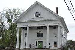 Town Hall | ||
| ||
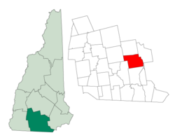 Location in Hillsborough County, New Hampshire | ||
| Coordinates: 42°56′47″N 71°30′57″W / 42.94639°N 71.51583°WCoordinates: 42°56′47″N 71°30′57″W / 42.94639°N 71.51583°W | ||
| Country | United States | |
| State | New Hampshire | |
| County | Hillsborough | |
| Incorporated | 1750 | |
| Government | ||
| • Town Council |
Bill Duschatko, Chair Melissa Stevens Chris Bandazian Kelleigh Murphy David Gilbert Catherine Rombeau Phil Greazzo | |
| • Town Manager | Rick Sawyer[1] | |
| Area | ||
| • Total | 33.1 sq mi (85.8 km2) | |
| • Land | 32.8 sq mi (85.0 km2) | |
| • Water | 0.3 sq mi (0.7 km2) 0.85% | |
| Elevation | 308 ft (94 m) | |
| Population (2010) | ||
| • Total | 21,203 | |
| • Density | 640/sq mi (250/km2) | |
| Time zone | UTC−5 (Eastern) | |
| • Summer (DST) | UTC−4 (Eastern) | |
| ZIP code | 03110 | |
| Area code | 603 | |
| FIPS code | 33-04500 | |
| GNIS feature ID | 0873541 | |
| Website |
www | |
Bedford is a town in Hillsborough County, New Hampshire, United States. The population was 21,203 at the 2010 census.[2] Bedford is a suburb of Manchester, the largest city in the state of New Hampshire.
History
In 1733, Massachusetts established Bedford as "Narragansett, No. 5" for the benefit of soldiers who fought against the Narragansett Indians in Rhode Island.[3] The area was also known as "Souhegan East". The settlement was incorporated as Bedford in 1750,[4] and was named for Lord Russell, the Fourth Duke of Bedford.[5] Lord Russell was the Secretary of State for the Southern Department from 1748-1751 and a close friend of Governor Benning Wentworth, whose first wife, Diana Spencer, was cousin to the Duke of Marlborough.[6]
The first settlers in Bedford were Robert and James Walker III. A monument dated 1737 stands on what is now known as Station Road (adjacent to Hawthorne Drive), marking the first settlement. Bedford's first moderator was Mayor John Goffe, son of Colonel John Goffe, for whom Goffstown was named.
In 1874, Bedford was served by Concord Railroad, and service by the Manchester and Ashburnham Railroad was being planned.[7]
Like much of southeastern New Hampshire, Bedford has grown rapidly over the last fifty years. The 2000 population of 18,274 was over eight times the population in 1950 of 2,176. Every decade has had a substantial rate of growth, ranging from 33 percent between 1980–1990 to a 67 percent increase between 1950-60. The 2005 population estimate by the New Hampshire Office of Energy and Planning was 20,738 residents,[8] which ranked 13th among New Hampshire's incorporated cities and towns.
Geography
According to the United States Census Bureau, the town has a total area of 33.1 square miles (86 km2), of which 32.8 sq mi (85 km2) is land and 0.3 sq mi (0.78 km2) is water, comprising 0.85% of the town. The largest body of water other than the Merrimack River is Sebbins Pond, which is connected to smaller, neighboring bodies of water by Sebbins Brook. Bedford is bordered by the town of Goffstown and the city of Manchester to the north, by Manchester to the east across the Merrimack River, by the town of Merrimack to the south, and by the towns of Amherst and New Boston to the west.
A rock formation called Pulpit Rock (originally the Devil's Pulpit) is located in the northwest part of the town on New Boston Road and is the feature of the town-owned Pulpit Rock Conservation Area. The highest point in Bedford is Holbrook Hill, at 845 feet (258 m) above sea level, located in the extreme northwest corner of town. Bedford lies fully within the Merrimack River watershed.[9]
Transportation
Two major highways run through Bedford. The Everett Turnpike runs north-south, and Route 101 runs east-west. The segment of the Everett Turnpike north of NH 101 and the segment of NH 101 east of the Everett Turnpike are designated Interstate 293; I-293 turns at this interchange.
The portion of Route 101 in eastern Bedford is a freeway, while the majority of the route through Bedford and to the west is a surface road. US 3 and Route 114 also run through Bedford.
Manchester-Boston Regional Airport is one town away, in Manchester.
Demographics
| Historical population | |||
|---|---|---|---|
| Census | Pop. | %± | |
| 1790 | 898 | — | |
| 1800 | 1,182 | 31.6% | |
| 1810 | 1,296 | 9.6% | |
| 1820 | 1,375 | 6.1% | |
| 1830 | 1,554 | 13.0% | |
| 1840 | 1,549 | −0.3% | |
| 1850 | 1,914 | 23.6% | |
| 1860 | 1,172 | −38.8% | |
| 1870 | 1,221 | 4.2% | |
| 1880 | 1,204 | −1.4% | |
| 1890 | 1,102 | −8.5% | |
| 1900 | 1,148 | 4.2% | |
| 1910 | 1,110 | −3.3% | |
| 1920 | 1,118 | 0.7% | |
| 1930 | 1,326 | 18.6% | |
| 1940 | 1,561 | 17.7% | |
| 1950 | 2,176 | 39.4% | |
| 1960 | 3,636 | 67.1% | |
| 1970 | 5,859 | 61.1% | |
| 1980 | 9,481 | 61.8% | |
| 1990 | 12,563 | 32.5% | |
| 2000 | 18,274 | 45.5% | |
| 2010 | 21,203 | 16.0% | |
| Est. 2015 | 22,204 | [10] | 4.7% |
| U.S. Decennial Census | |||
As of the census of 2010, there were 21,203 people, 7,364 households, and 5,834 families residing in the town. The population density was 646.4 people per square mile (249.4/km²). There were 7,634 housing units at an average density of 232.7 per square mile (89.8/km²). The racial makeup of the town was 94.5% White, 0.6% African American, 0.1% Native American, 2.9% Asian, 0.01% Pacific Islander, 0.4% from some other race, and 1.4% from two or more races. Hispanic or Latino of any race were 1.7% of the population.
There were 7,364 households out of which 40.9% had children under the age of 18 living with them, 69.8% were headed by married couples living together, 6.5% had a female householder with no husband present, and 20.8% were non-families. 16.5% of all households were made up of individuals, and 7.6% were someone living alone who was 65 years of age or older. The average household size was 2.81 and the average family size was 3.19.
In the town, the age distribution of the population shows 28.6% under the age of 18, 4.7% from 18 to 24, 21.4% from 25 to 44, 31.7% from 45 to 64, and 13.5% who were 65 years of age or older. The median age was 42.3 years. For every 100 females, there were 95.7 males. For every 100 females age 18 and over, there were 92.1 males.[2]
For the period 2006–2010, the median income for a household in the town was $116,299 (in 2010 dollars), and the median income for a family was $127,589. Full-time male workers had median earnings of $99,366 versus $53,286 for females. The per capita income for the town was $50,952. About 2.7% of families and 3.4% of the population were below the poverty line, including 4.2% of those under age 18 and 1.0% of those age 65 or over.[11] Bedford had the fifth highest average personal income in the state between 2006 and 2010.[12]
Education
There are six schools in Bedford: Memorial (National Blue Ribbon School awardee in 2012) , Peter Woodbury and Riddle Brook (National Blue Ribbon School awardee in 2017) are neighborhood elementary schools and accommodate grades K through 4. McKelvie Intermediate School accommodates grades 5 and 6. In 2007, Ross A. Lurgio Middle School (grades 7 and 8) and Bedford High School (grades 9 through 12) opened.
Ross A. Lurgio Middle School and Bedford High School comprise one 300,000 sq ft (28,000 m2) building. This was done to support economies of scale (shared kitchen, auditorium, security), but they operate as separate schools with different entrances, bus schedules, start times and end times. Additionally, key-controlled access is required to move between schools.
A small number of athletic fields on the campus of Saint Anselm College are located in Bedford.
Notable people
- Silas Aiken (1799–1869), minister and author[13]
- David Atwood (1815–1889), newspaperman and U.S. congressman from Wisconsin; born in Bedford[14]
- Chris Carpenter, pitcher with the St. Louis Cardinals[15]
- Zachariah Chandler (1813-1879), U.S. Secretary of the Interior 1875-77 and U.S. Senator of Michigan; born in Bedford[16]
- John Goffe, colonial soldier[17]
- Carrie Jones (1971–), bestselling author of young adult novels; born in Bedford[18]
- Dean Kamen, inventor of the Segway HT and the iBOT; owner of Manchester-based DEKA Corporation[19]
- Josh Meyers, actor and comedian[20]
- Seth Meyers, comedian and talk-show host, (Saturday Night Live, Late Night with Seth Meyers)[21]
- Mace Moulton, U.S. congressman[22]
- Patricia Racette, opera singer[23]
- Laura Silverman, actress[24]
- Sarah Silverman, comedian[25]
- John E. Sununu, U.S. senator (2003–09)[26]
- Peter Woodbury, judge of the United States Court of Appeals for the First Circuit[27]
References
- ↑ Boufford, Dawn. "TOWN OF BEDFORD TOWN COUNCIL MEETING April 13, 2016" (PDF). Town of Bedford. Town of Bedford. Retrieved 4 May 2016.
- 1 2 "Profile of General Population and Housing Characteristics: 2010 Demographic Profile Data, Bedford town, Hillsborough County, New Hampshire (DP-1)". American Factfinder. U.S. Census Bureau. Retrieved 2012-11-27.
- ↑ "Bedford". Statistics and Gazetteer of New-Hampshire, 1875. Retrieved December 19, 2013.
- ↑ "Bedford, New Hampshire". City-Data.com. Retrieved December 19, 2013.
- ↑ "Profile for Bedford, New Hampshire, NH". ePodunk. Retrieved December 19, 2013.
- ↑ Laybourn, Keith (2001). British Political Leaders: A Biographical Dictionary. Keith. p. 29. ISBN 9781576070437.
- ↑ "Bedford". Statistics and Gazetteer of New-Hampshire, 1875. Retrieved December 19, 2013.
- ↑ "2005 Population Estimates of New Hampshire Cities and Towns" (PDF). New Hampshire Office of Energy and Planning. July 2006. Archived from the original (PDF) on 2007-07-11. Retrieved 2012-12-01.
- ↑ Foster, Debra H.; Batorfalvy, Tatianna N.; Medalie, Laura (1995). Water Use in New Hampshire: An Activities Guide for Teachers. U.S. Department of the Interior and U.S. Geological Survey.
- ↑ "Annual Estimates of the Resident Population for Incorporated Places: April 1, 2010 to July 1, 2015". Retrieved July 2, 2016.
- ↑ "SELECTED ECONOMIC CHARACTERISTICS: 2006–2010 American Community Survey 5-Year Estimates (DP-3) – Bedford town, Hillsborough County, New Hampshire (DP-3)". American Factfinder. U.S. Census Bureau. Retrieved 2012-11-27.
- ↑ "SELECTED ECONOMIC CHARACTERISTICS: 2006–2010 American Community Survey 5-Year Estimates (DP-3) – All Towns, New Hampshire". American Factfinder. U.S. Census Bureau. Retrieved 2012-11-27.
- ↑ Kingsbury, John Dennison (1870). Sketch of Rev. Silas Aiken. Welch, Bigelow and Company. p. 3.
- ↑ "ATWOOD, David (1815 - 1889)". Biographical Directory of the United States Congress. United States Congress. Retrieved February 21, 2018.
- ↑ "Chris Carpenter". New Hampshire.com. Retrieved December 19, 2013.
- ↑ "Zachariah Chandler - American politician". britannica.com. Retrieved 26 March 2018.
- ↑ Daughters of the American Revolution (1905). Lineage Book – National Society of the Daughters of the American Revolution, Volume 19. Daughters of the American Revolution. p. 225.
- ↑ "An Interview with Carrie Jones". The Fictionistas. September 25, 2008. Retrieved February 21, 2018.
- ↑ "Dean Kamen's House Rivals Best Industrial Museums". Design News. Retrieved December 19, 2013.
- ↑ "For Seth Meyers, you can go home again". Bedford Journal. Retrieved December 19, 2013.
- ↑ Dobbs, Katelyn. "For Seth Meyers, you can go home again". Bedford Journal. Retrieved 2012-07-14.
- ↑ "Biography of HON. MACE MOULTON of Manchester NH". GENEALOGY AND HISTORY OF MANCHESTER NEW HAMPSHIRE TRANSCRIBED BY JANICE BROWN. Retrieved December 19, 2013.
- ↑ "A Soprano's Hat Trick: Puccini Triple Bill". The New York Times. Retrieved December 19, 2013.
- ↑ "Hollywood sisters say farewell to Granite State roots - New Hampshire". newhampshire.com. Retrieved 26 March 2018.
- ↑ Willis, John and Monush, Barry (2010). Screen World 2006. Hal Leonard Corporation. p. 404.
- ↑ "Candidate Profile from Congressional Quarterly: John E. Sununu (R) of Bedford". CNN.com. Retrieved February 21, 2018.
- ↑ "Woodbury, Peter". Biographical Directory of Article III Federal Judges, 1789-present. Federal Judicial Center. Retrieved February 21, 2018.
External links
| Wikimedia Commons has media related to Bedford, New Hampshire. |
- Town of Bedford official website
- Bedford Historical Society
- New Hampshire Economic and Labor Market Information Bureau Profile
- Bedford Men's Club official website
Places adjacent to Bedford, New Hampshire | |
|---|---|
Municipalities and communities of Hillsborough County, New Hampshire, United States | ||
|---|---|---|
| Cities |  | |
| Towns | ||
| CDPs | ||
| Other villages | ||